10,000-Year-Old Rock Paintings Depict UFOs And Aliens
The State Department of Archaeology and Culture in Chhattisgarh, India, is seeking assistance from the Indian Space Research Organisation to research a set of ancient rock paintings found inside caves near the town of Charama in Kanker district, in the tribal Bastar region, according to a news report in the Times of India.
According to one archaeologist, the art reflects the belief among ancient humans that we are not alone in the universe.
The Indian state of Chhattisgarh has an abundance of ancient rock paintings, according to their website. Many sites have paintings of humans and animals in everyday scenes.
However, some researchers have referred to more unusual paintings, such as those depicting what appear to be kangaroos and giraffes, which are not native to the country, as well as human-fish hybrid creatures. Now, it is claimed that aliens and UFOs can be added to this collection.
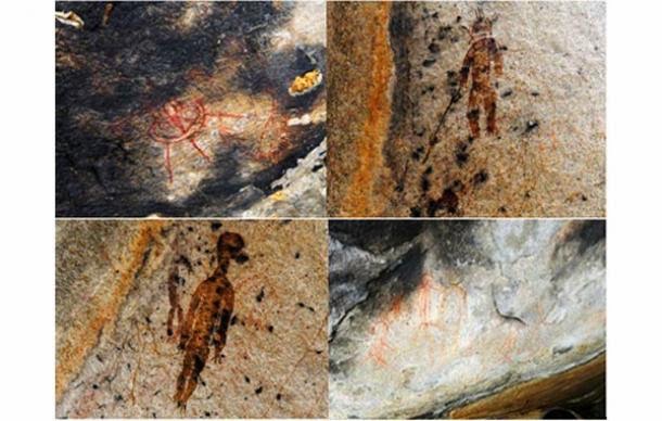
“The paintings are done in natural colours that have hardly faded despite the years. The strangely carved figures are seen holding weapon-like objects and do not have clear features. Especially, the nose and mouth are missing. In a few pictures, they are even shown wearing space suits,” said archaeologist JR Bhagat.
Bhagat, who has studied rock art, claims that the newly-discovered depictions date back some 10,000 years, although the dating method has not been clarified.
Bhagat suggests that the images may depict extra-terrestrials and UFOs as the paintings include large, humanoid beings descending from the sky, some wearing what looks like a helmet or antennae, as well as a disc-shaped craft with three rays (or legs) coming from its base.
“The findings suggest that humans in prehistoric times may have seen or imagined beings from other planets which still creates curiosity among people and researchers.
“Extensive research is needed for further findings. Chhattisgarh presently doesn’t have any such expert who could give clarity on the subject,” Bhagat told the Times of India.
One of the ancient rock paintings
Bhagat explained that there are several beliefs among locals from the area.
While few worship the paintings, others narrate stories they have heard from ancestors about “rohela people”, which translates to “the small sized ones”.
According to legend, the rohela people used to land in the sky in a round-shaped flying object and take away one or two persons of the village who never returned. However, Bhagat does concede,
“We can’t refute the possibility of imagination by prehistoric men.”
Bhagat has not made reference to the fact that the paintings in question depict what, in other contexts, archaeologists typically identify as shamanic images of humans, human-animal hybrids, and geometric forms. Images of figures with antlers, antennae, or spirit rays are familiar, and in fact quite common, in shamanic art.
The research on the rock paintings is ongoing, and Bhagat says more archaeologists will be consulted to help identify the mysterious creatures and objects in the ancient artwork.
Rare Roman coin bearing Cancer zodiac sign found off Israeli Coast
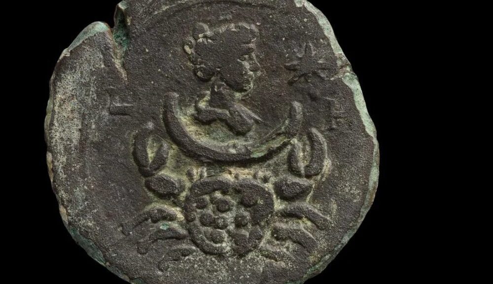
A nearly 2,000-year-old Roman coin, etched with a symbol of the zodiac, was fished from the waters around Haifa in northern Israel, reports the Agence France-Presse (AFP).
The coin depicts Luna, the goddess of the moon, and the zodiac sign for Cancer.
Archaeologists with the Israel Antiquities Authority (IAA) made the discovery while conducting an underwater archaeological survey.
The bronze coin was minted in Alexandria, Egypt, during the reign of the Roman emperor Antoninus Pius, and it was found in “an exceptional state of preservation,” according to a statement from the Israeli prime minister’s office, per Google Translate.
One side of the coin features an image of Luna, the Roman goddess of the moon, and an image of the zodiac sign for Cancer; the other side depicts Antoninus Pius.
The coin also bears the inscription “Year Eight,” indicating that it was produced during the eighth year of Pius’ rule, which spanned from 138 to 161 C.E.
This ancient relic belonged to a series of 13 coins, portraying the 12 signs of the zodiac and the complete zodiac wheel, per a statement from IAA. It is the first such coin that has been discovered off the coast of Israel.
Astrology, which originated in Mesopotamia circa the third millennium B.C.E., was deeply entrenched in Roman culture.
Though sometimes viewed with suspicion and hostility by emperors, who understood that astrological predictions could be used to subvert their authority, astrology was a popular practice among all classes of Roman society.
“Astrology was only one of a wider number of divinatory practices in the empire,” writes Matthew Bunson in the Encyclopedia of the Roman Empire. “But for capturing the public interest and imagination, all paled alongside astrology.”
Pius led the empire through one of its most peaceful eras. Before this period, hostilities abounded in what is now Israel—particularly in the years after 70 C.E., when Roman forces destroyed the Second Temple in Jerusalem.
In 130 C.E., the emperor Hadrian initiated plans to build a Roman metropolis in Jerusalem. He also outlawed circumcision, a core practice in Judaism.
Shortly afterwards, Jews launched a rebellion against Roman rulers known as the Bar Kochba Revolt. Roman forces ultimately quashed the rebellion after three years of fighting and “enormous losses” on both sides.
Conversely, Pius, who succeeded Hadrian, was “not a military man,” writes the Washington Post’s Rachel Pannett. He helped cool relations with the empire’s Jews by allowing them to resume the practice of circumcision.
The bronze coin depicting Pius was found near a “small hoard” of other coins, indicating that it fell into the sea during a shipwreck, Jacob Sharvit, head of the IAA’s marine archaeology unit, tells the AFP.
“Along the shores of the Mediterranean Sea in the State of Israel, and in its maritime space, there are many archaeological sites and findings, which tell of connections that existed here in ancient times between the ports of the Mediterranean Sea and the countries along it,” Sharvit says in the statement from the prime minister’s office.
These ancient sites must be safeguarded “in the light of diverse development interests” along Israel’s coasts, says Eli Eskosido, the IAA’s general director, in the IAA statement.
“Rather than simply defining the country’s border,” he adds, “the sea is now recognized as an integral part of our cultural heritage.”
8,000-Year-Old Neolithic Temple Discovered at Saudi Port Town
The Saudi Heritage Commission has unveiled the archaeological discoveries made by a Saudi-international scientific team at the site of Al-Faw, located on the edge of Al-Rub’ Al-Khali (the Empty Quarter), south-west of Riyadh.
Visitors walk outside the tombs at the Madain Saleh antiquities site, al-Ula, Saudi Arabia February 10, 2019. Stephen Kalin, Reuters
A Saudi-led multinational team of archaeologists conducted a comprehensive survey of the site using state-of-the-art technology.
The study leveraged high-quality aerial photography; guided drone footage utilizing ground control points; a topographic survey; remote sensing, ground-penetrating radar; laser scanning; and geophysical survey, as well as extensive walkover surveys and sondages throughout the site, reported Saudi Press Agency (SPA).
Experts used photography, drone topographic surveying and geophysical surveying to discover the findings.
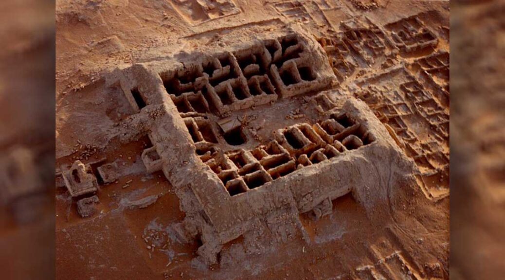
The survey has yielded several discoveries, the most significant of which are the remains of a stone temple and parts of an altar, where the locals of Al-Faw would have practised their rituals and ceremonies.
The rock-cut temple sits on the edge of Mount Tuwaiq, known as Khashem Qaryah, east of Al-Faw.
Rock drawings found etched on Tuwaiq Mountain depict daily activities, including hunting, travelling, and fighting.
Moreover, the remains of 8,000-year-old Neolithic human settlements have been discovered along with 2,807 graves of different periods dotted throughout the site, which have been documented and classified into six groups.
Several devotional inscriptions were found throughout the grounds, enriching our understanding of the religious belief system of the community that inhabited the site. Among these is the inscription in the Jabal Lahaq sanctuary addressed to the god Kahal, the deity of Al-Faw.
The significance of the inscription lies in its attribution to a family from the city of Al-Jarha and referring to the ancient name of the place where the sanctuary was built (Mount Tuwaiq).
The inscription indicates a relationship between the cities of Al-Faw and Al-Jarha – most likely commercial considering Al-Faw’s location on the ancient trade route. It may also imply either religious tolerance between residents of the two cities, or the worship of Al-Faw’s deity, Kahal, by some of the residents of Al-Jarha.
Though Al-Jarha was known for its wealth and economic power, its location has not yet been definitively identified, and several scholars associate it with the site of Thaj.
The discovery offers valuable data regarding the geographical distribution of Al-Faw’s sanctuaries, as well as revealing the foundations of four monumental buildings, some with corner towers. Their architecture, internal plans, and open-air courtyards suggest their use as resting places for trade caravans.
The archaeological study further uncovered a complex irrigation system, including canals, water cisterns, and hundreds of pits, dug by the residents of Al-Faw to bring rainwater to the agricultural areas. This may explain how the inhabitants of these lands overcame and adapted to the arid climate and minimal rainfall of one of the world’s harshest desert environments.
Extensive surveys and remote-sensing images have revealed several agricultural fields used to grow various crops to sustain residents.
Discoveries include a series of rock art and inscriptions carved on the face of Mount Tuwaiq, narrating the story of a man named Madhekar bin Muneim, and illustrating daily scenes of hunting, travel, and battle.
Fieldwork at Al-Faw had first been initiated by King Saud University in the 1970s in a study supervised by Prof. Abdulrahman Al-Ansari, lasting for over 40 years. The study uncovered many cultural aspects of the site, notably the residential and market areas, temples, and tombs. The results of these archaeological activities were later published in seven book volumes.
The new findings are a result of the Heritage Commission’s ongoing efforts to study, protect and preserve the nation’s cultural heritage sites. Research at the site will continue to build a greater understanding of the cultural landscape of Al-Faw archaeological area.
Human skeletons, and relics found in Pingtung date back 4,000 years: Archaeologists
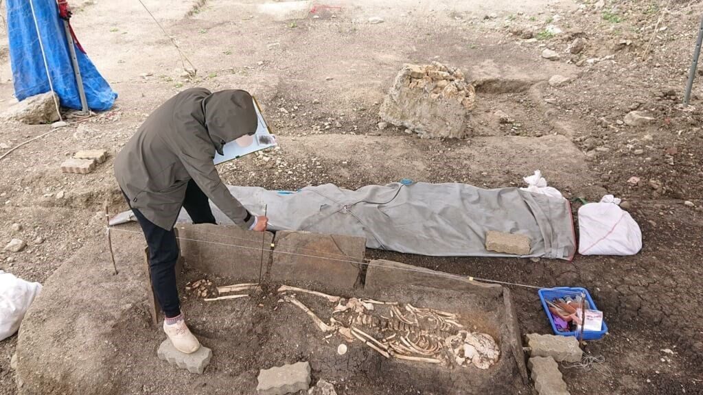
Taipei, July 27 (CNA) Archaeologists in Taiwan confirmed Wednesday that a large number of human skeletons and shell tools unearthed in Pingtung County are about 4,000 years old, which makes the shell tool site the oldest in the Pacific region.
Human skeletons, and relics found in Pingtung date back 4,000 years: Archaeologists
Chiu Hung-lin (邱鴻霖), an associate professor at National Tsing Hua University’s (NTHU) Institute of Anthropology, said he and his team had learned about the site in Eluanbi Park on the southern tip of Taiwan in 2017, when work began on a project to convert the dilapidated shops in the area into green structures.
The project was halted when the contractor found shell tools, human skeletal remains and slate coffins in a shallow site in the park, Chiu told CNA.
He said the Kenting National Park Headquarters then commissioned the NTHU team, led by him and Professor Li Kuang-ti (李匡悌), to excavate the site.
Between 2019 and 2021, the team unearthed a large number of relics and artefacts, including 51 skeletons, 10 of which were buried in slate coffins with coral funeral objects, Chiu said.
Fishing hooks are found among the shell tools. Source: National Tsing Hua University’s Facebook page @nthu.tw
Among the findings were several finished and unfinished shell tools, as well as relics that indicated it was a site for making those tools, which provided proof that the early inhabitants of Eluanbi used “unique” shell-crafting techniques, Chiu said.
The site also offered insights into the funeral customs of the people in those times, he said, adding that anthropologists could also make new discoveries by studying the human remains found at the site.
The skeletal remains and shell tools date back about 4,000 years, which means it is the oldest shell tool site found on any island in the Pacific region, Chiu said, adding that it was also the largest.
Meanwhile, the discovery of an archaeological site on a commercial project has negatively affected the livelihood of the local residents, Chiu said, calling on authorities to find a balance between development and the preservation of cultural heritage sites.
He also urged the local government to address the issue of proper facilities for the exhibition of the artefacts so that people can learn about the archaeological and historical value of the findings.
Coupled with the renovation of the shops, this would help to boost Pingtung’s tourism and the income of its residents, Chiu said.
Earthquake Detector Invented 2,000 Years Ago In China
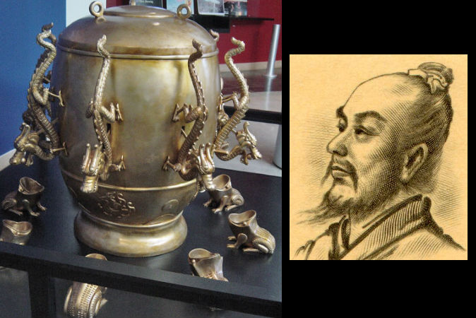
Although we still cannot accurately predict earthquakes, we have come a long way in detecting, recording, and measuring seismic shocks. Many don’t realize that this process began nearly 2,000 years ago, with the invention of the first seismoscope in 132 AD by a Chinese inventor called Zhang (‘Chang’) Heng.
The device was remarkably accurate in detecting earthquakes from afar and did not rely on shaking or movement in the location where the device was situated.
The ancient Chinese did not understand that earthquakes were caused by the shifting of tectonic plates in the Earth’s crust; instead, the people explained them as disturbances with cosmic yin and yang, along with the heavens’ displeasure with acts committed (or the common peoples’ grievances ignored) by the currently ruling dynasty.
Considering the ancient Chinese believed seismic events were important signs from heaven, it was important for the Chinese leaders to be alerted to earthquakes occurring anywhere in their kingdom.
Zhang Cheng was an astronomer, mathematician, engineer, geographer and inventor, who lived during the Han Dynasty (25 – 220 AD). He is credited with developing the world’s first earthquake detector. Zhang’s seismoscope was a giant bronze vessel, resembling a samovar almost 6 feet in diameter.
Eight dragons snaked face-down along the outside of the barrel, marking the primary compass directions. In each dragon’s mouth was a small bronze ball. Beneath the dragons sat eight bronze toads, with their broad mouths gaping to receive the balls.
The exact mechanism that caused a ball to drop in the event of an earthquake is still unknown. One theory is that a thin stick was set loosely down the centre of the barrel.
An earthquake would cause the stick to topple over in the direction of the seismic shock, triggering one of the dragons to open its mouth and release the bronze ball.
The sound of the ball striking one of the eight toads would alert observers to the earthquake and would give a rough indication of the earthquake’s direction of origin.
In 138 AD, the sound of the bronze ball dropping caused a stir among all the imperial officials in the palace. No one believed that the invention actually worked.
According to the direction in which the dragon that dropped the ball was oriented, it was determined that the quake had occurred to the west of Luoyang, the capital city. Since no one had sensed anything in Luoyang proper, people were sceptical.
However, a few days later, a messenger from the western Long region (today, southwest Gansu province), which was west of Luoyang, reported that there had been an earthquake there. As it happened exactly the same time that the seismometer was triggered, people were greatly impressed by Zhang Heng’s instrument.
In 2005, scientists in Zhengzhou, China (which was also Zhang’s hometown) managed to replicate Zhang’s seismoscope and used it to detect simulated earthquakes based on waves from four different real-life earthquakes in China and Vietnam.
The seismoscope detected all of them. As a matter of fact, the data gathered from the tests corresponded accurately with that gathered by modern-day seismometers!
Today, from an advanced modern science and technology point of view, the seismometer Zhang Heng invented is still considered amazingly refined and remarkable and way ahead of its time.
Oopart (out of place artefact) is a term applied to dozens of prehistoric objects found in various places around the world that seem to show a level of technological advancement incongruous with the times in which they were made.
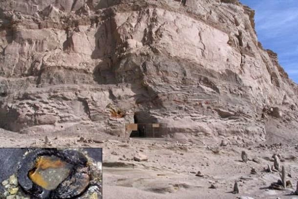
Ooparts often frustrate conventional scientists, delight adventurous investigators open to alternative theories, and spark debate. In a mysterious pyramid in China’s Qinghai Province near Mount Baigong are three caves filled with pipes leading to a nearby salt-water lake. There are also pipes under the lake bed and on the shore.
The iron pipes range in size, with some smaller than a toothpick. The strangest part is that they may be about 150,000 years old.
Dating done by the Beijing Institute of Geology determined these iron pipes were smelted about 150,000 years ago, if they were indeed made by humans, according to Brian Dunning of Skeptoid.com.
And if they were made by humans, history, as it is commonly viewed, would have to be re-evaluated.
The dating was done using thermoluminescence, a technique that determines how long ago crystalline mineral was exposed to sunlight or heated. Humans are only thought to have inhabited the region for the past 30,000 years.
Even within the known history of the area, the only humans to inhabit the region were nomads whose lifestyle would not leave any such structures behind.
The state-run news agency Xinhua in China reported on the pyramid, the pipes, and the research began by a team of scientists sent to investigate in 2002.
Though some have since tried to explain the pipes as a natural phenomenon, Yang Ji, a research fellow at the Chinese Academy of Social Sciences, told Xinhua the pyramid may have been built by intelligent beings.
He did not dismiss the theory that ancient extraterrestrials may be responsible, saying this theory is:
“understandable and worth looking into… but scientific means must be employed to prove whether or not it is true.”
Another theory is that it was built by prehistoric humans with techniques lost to humans of a later period.
The pipes lead into a salty lake, though a twin lake nearby contains freshwater. The surrounding landscape is strewn with what Xinhua described as “strangely shaped stones.” Rocks protrude from the ground like broken pillars.
The head of the publicity department at the local Delingha government told Xinhua the pipes were analyzed at a local smeltery and 8 per cent of the material could not be identified. The rest was made up of ferric oxide, silicon dioxide, and calcium oxide.
The silicon dioxide and calcium oxide are products of long interaction between the iron and surrounding sandstone, showing the ancient age of the pipes. Liu Shaolin, the engineer who did the analysis, told Xinhua:
“This result has made the site even more mysterious. Nature is harsh here,” he said. “There are no residents let alone modern industry in the area, only a few migrant herdsmen to the north of the mountain.”
To further add to the mystery, Zheng Jiandong, a geology research fellow from the China Earthquake Administration told the state-run newspaper People’s Daily in 2007 that some of the pipes were found to be highly radioactive.
Other Theories
Jiandong said iron-rich magma may have risen from deep in the Earth, bringing the iron into fissures where it would solidify into tubes. Though he admitted,
“There is indeed something mysterious about these pipes.”
He cited radioactivity as an example of the strange qualities of the pipes. Others have said iron sediments may have washed into the fissures, carried with water during floods.
Though Xinhua and other publications in China have referred to a pyramid or even a mysterious pyramid in which the pipes were found, some have said it was a pyramid-shaped natural formation. Another theory is that the pipes are fossilized tree roots. Xinmin Weekly reported in 2003 that scientists found plant matter in an analysis of the pipes, and they also found what looked like tree rings.
The article related the finding to a geological theory that in certain temperatures and under certain chemical conditions, tree roots can undergo diagenesis (transformation of soil into rock) and other processes that can produce iron formations.
Reports on the tree-root explanation for the so-called Baigong pipes often lead back to this Xinmin Weekly article or lack citation. It’s unclear exactly how well-supported this theory is in relation to the Baigong pipes.
An article published in the Journal of Sedimentary Research in 1993 describes fossilized tree roots in South Louisiana in the United States.
The Mysterious 1,300-Year-Old Siberian Lake Fortress
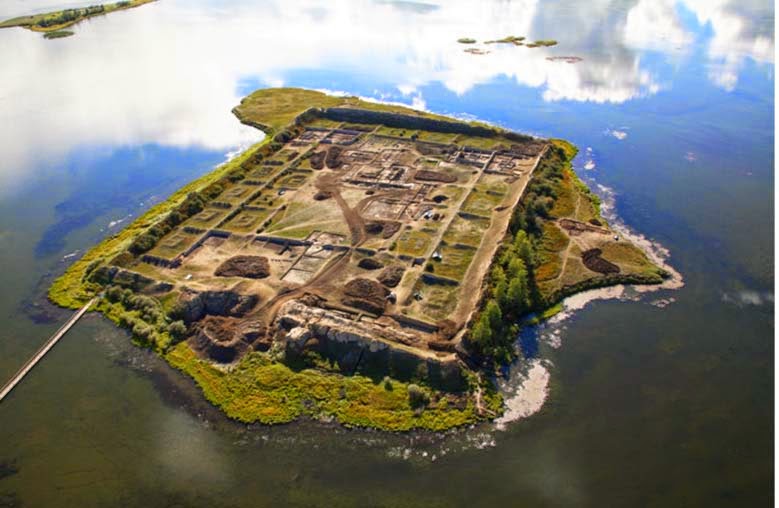
It is one of the most mysterious archaeological sites in Russia – an ancient complex engulfing a small island in the centre of a remote lake in the mountains of southern Siberia. At first glance, it appears to be an ancient fortress, its perimeter of high walls constructed to keep out enemies.
However, others have proposed the 1,300-year-old structure may have been a summer palace, monastery, memorial complex, ritual centre, or astronomical observatory.
According to the Siberian Times, more than a century after its rediscovery, experts are no closer to understanding the secrets of these enigmatic ruins.
The archaeological site is known as Por Bajin (also spelt Por-Bazhyn), meaning ‘clay house’. It is located on an island in the middle of Tere-Khol Lake in Tuva, Siberia, just 20 miles (32 km) from the Mongolian border.
First explored in 1891, the site was not excavated until 1957-1963. However, it was not until 2007-2008 that the first large-scale research was undertaken, carried out by the Por Bajin Cultural Foundation.
What they discovered presented a conundrum – the structure is located in a very remote place on the outskirts of what was the Uighur nomad empire, built with Chinese features, but with no sign of permanent habitation, and abandoned after only a short period of use.
Why was it built? How was it used? And why was it abandoned? These are the questions that have continued to both fascinate and frustrate experts ever since its discovery.
Inside the complex of Por Bajin.
The Construction of Por Bajin
Believed to have been constructed in 757 AD, the ancient complex has outer walls that still rise to 40 feet (12 meters) in height and inner walls of 3-5 feet (1 – 1.5 meters), some still covered with lime plaster painted with horizontal red stripes. The main gate was discovered, opening into two successive courtyards connected by another gate.
The walls enclose an area of about seven acres containing the remains of more than 30 buildings, but with a two-part central structure linked by a covered walkway, which once had a tiled roof and was supported by 36 wooden columns resting on stone bases.
Laser mapping of the site prior to the first major excavation in 2007 helped experts build a 3D model of what the complex might have looked like.
Por-Bajin reconstruction seen from the east.
Only a small number of artefacts were ever recovered from the site – if it had been permanently inhabited one would expect to find a much greater number of items. There was also no evidence of any kind of heating system, which would have made it impossible to stay there, at 2,300 meters above sea level, in winter conditions.
The main finds include clay tablets of human feet, faded coloured drawings, fragments of burnt wood, roof tiles, an iron dagger, a stone chalice, one silver earring, and iron construction nails. None of the artefacts provides a definitive answer as to why the structure was built, and how it was used.
One of the tiles was found at Por Bajin.
Since the end of the 19th century, Por-Bajin has been linked to the Uighur Khaganate nomadic empire (744 – 840 AD), composed of nomadic Turkic-speaking people held together by forces of warriors on horseback. The empire spanned Mongolia and southern Siberia, however, the location of Por Bajin was still well away from settlements and trade routes.
Why would they build in such a remote location? Could it have been the site of a palace or a memorial for a ruler? The unique layout, more ornate than that of other Uighur fortresses of the period, has led some scholars to suggest that it might have had a ritual role.
Still, there are some other puzzling features. The architecture reflects a distinctive Chinese style, as evidenced by the use of Chinese building materials, such as certain types of roof tiles, and the use of Chinese construction methods.
The layout, with its axial planning, dominant central building, and residential quarters is consistent with styles seen in other Buddhist monasteries. But Por-Bajin shows no evidence of religious practice.
Small yards (left) running along Por-Bajin’s walls each had a building in the centre. A digital reconstruction (right) based on excavations shows that each building could have functioned as a dwelling, perhaps for monks if the site were a monastery.
Why was it abandoned?
Not only has Por Bajin presented a mystery regarding its purpose, but archaeological evidence suggests it was abandoned after only a short period of use.
No evidence has been found to suggest the complex came under attack from an opposing force. Political changes in the region may offer one possible explanation, although nothing concrete has been presented to support this theory.
According to Dmitriy Subetto, from the Department of Physical Geography RGPU, the structure may have been abandoned prior to completion due to the builders’ lack of familiarity with the permafrost.
For now, Por Bajin remains one of Russia’s enduring mysteries.
The Mysterious Man-Made Caves Of Longyou: 10 Unanswered Questions
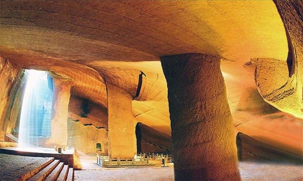
Located near the village of Shiyan Beicun in Zhejiang province, China lies the Longyou caves – an extensive, magnificent and rare ancient underground world considered in China as ‘the ninth wonder of the ancient world’.
The Longyou grottoes, which are thought to date back at least 2,000 years, represent one of the largest underground excavations of ancient times and are an enduring mystery that has perplexed experts from every discipline that has examined them. Scientists from around the world in the fields of archaeology, architecture, engineering, and geology have absolutely no idea how they were built, by whom, and why. First discovered in 1992 by a local villager, 36 grottoes have now been discovered covering a massive 30,000 square metres. Carved into solid siltstone, each grotto descends around 30 metres underground and contains stone rooms, bridges, gutters and pools.
There are pillars evenly distributed throughout the caves which are supporting the ceiling, and the walls, ceiling and stone columns are uniformly decorated with chisel marks in a series of parallel lines. Only one of the caves has been opened for tourism, chosen because of the stone carvings found inside which depict a horse, fish and bird. The Longyou caves truly are an enigma and here we will explore ten mysteries that are still unexplained despite more than two decades of research.
1. How were they constructed?
A rough estimation of the workload involved in building these five caves is awe-inspiring. The quantity of rock that would have been removed in the overall excavation of the grottoes is estimated to be nearly 1,000,000 cubic meters. Taking into account the average digging rate per day per person, scientists have calculated that it would take 1,000 people working day and night for six years to complete. These calculations are based purely on hard labour, but what they haven’t taken into account is the incredible care and precision of the sculptors, meaning that the actual workload would far surpass the theoretical estimation. As for how they were constructed and what tools were used, it is still unknown. No tools have been found in the area, and, as we will explore later, scientists still don’t know how they achieved such symmetry, precision, and similarity between the different caves.
2. No traces of construction
Despite their size and the effort involved in creating them, so far no trace of their construction or even their existence has been located in the historic record. Although the overall excavation involved almost a million cubic metres of stone, there is no archaeological evidence revealing where that quantity of stone went, and no evidence of the work. Moreover, there is not a single historic document that refers to them, which is highly unusual considering the sheer scale of the project. Their origin is a complete and utter mystery.
3. Why were the walls chiselled?
Every single one of the caves is covered, from floor to ceiling, in parallel lines that have been chiselled into virtually every surface.
The effect is a uniform pattern throughout the caves, which would have required immense manpower and endless hours to create. The question is why? Was such labour-intensive work purely for decoration?
Are the lines or patterns symbolic in some way? All that is currently known is that the markings are similar to those found on pottery housed in a nearby museum, which is dated between 500 and 800 BC.
4. Lack of fish
When the caves were first discovered, they were filled with water, which presumably had been there for a long period of time. They had to be pumped out in order to realise that these were not just like the other ‘bottomless ponds’ found within the area, but man-made structures. Most villages in southern China contain very deep ponds, which have been called “bottomless ponds” by generations of villagers. These ponds teem with fish, which are easily caught. However, after the first cave was pumped dry, not a single fish was to be seen, or any other sign of life.
5. How did the caves remain so well preserved?
One of the most interesting and challenging questions is how the caves have been able to keep their structural integrity for more than 2000 years. There are no signs of collapse, no piles of rubble, and no damage despite the fact that in some areas the walls are only 50 centimetres thick. Over the centuries, the area has gone through numerous floods, calamities and wars, the mountains have changed their appearance and exposed stones have been weathered, but inside the caves, the form, patterns and markings are still clear and precise – it is as though they were built yesterday.
6. How did the builders work in the dark?
Due to the great depths of the caves, some areas at the bottom, which are not exposed to the opening above, are pitch-black. Yet even those dark areas are decorated with thousands of parallel lines on the walls, columns, and ceiling. So how did the ancient people work in the dark?
According to Jia Gang, a Tongji University professor specializing in civil engineering:
“There should be lamps, because the cave’s mouth is very small, and the sunbeam could only shine in the cave at a certain angle during a certain period of time. As one goes deeper into the cave, the light becomes dimmer. At the cave’s bottom, which is usually dozen of meters from the mouth, one could hardly see anything.”
However, this was at least two millennia ago and nothing that could have been used for lighting has been found.
7. Were the caves meant to be connected?
All of the 36 grottoes are distributed across an area of only one square kilometre. Considering such a high density, one cannot help asking whether some grottoes were meant to be connected. What would be the purpose of making so many separate caves in such a tight area without connecting them?
In many areas, the walls between the caves are very thin, only 50 centimetres, but they were never linked so it appears they were intentionally kept apart. What’s more, many of the caves are almost identical to each other.
8. Who built them?
Nobody has any idea who built the caves. Some scientists have claimed that it was not possible or logical for such as mammoth job to have been undertaken by regular village people.
Only the emperor and the leaders could have organised such a huge project, like the construction of the Great Wall, which was built to defend against invasion from the outside. But if it was commissioned by an Emperor, why are there no historical records of its construction?
9. How did they achieve such precision?
The scale of the Longyou Grottoes is magnificent and momentous, the design was delicate and scientific, the construction was sophisticated, and the precision is indicative of superior craftsmanship. The model, pattern and style of each cave are extremely similar. Every grotto is like a grand hall. One side is steep and another side is 45% inclined. The four walls are straight; the edges and corners are clearly demarcated. The chiselling marks are uniform and precise. According to Yang Hongxun, an expert at the Archaeological Institute of the Chinese Academy of Social Sciences,
“At the bottom of each cave, the ancient [builders] wouldn’t be able to see what the others were doing in the next grotto. But the inside of each cave had to be parallel with that of the other, or else the wall would be holed through. Thus the measuring apparatus should have been very advanced. There must have been some layout about the sizes, locations, and the distances between the caves beforehand.”
With the help of modern equipment and methods, the investigators measured the sizes of the walls and surprisingly found that the overall construction is extremely accurate. The walls between the caves are of the same thickness in different sections. So how did they achieve this precision? What were their methods?
10. What were they used for?
Following extensive investigations and study, scientists and scholars have attempted to put forward explanations for the grottoes, but none so far provide a convincing explanation for why they were built and what they were used for. Some archaeologists have suggested that the grottoes were the tombs of old emperors, emperor halls, or places for storage. But this interpretation is far-fetched. No funeral objects or tombs have been found and no artefacts left behind. If it were used like an emperor’s palace, the grottoes would have been designed differently with separate rooms for different purposes like entertaining, meeting, and sleeping, but no evidence can be found of this and no traces of habitation have been found.
Another hypothesis is that it was used for mining and extracting some type of mineral resource. However, mining operations would have required equipment and apparatus to extract the rocks and transport them. Again, no traces of this have been found, nor any evidence of where the rocks were taken. And of course, if the caves were just for mining, why create such intricate decorations on the walls, columns and ceilings?
Finally, some have suggested that the grottoes were the places for troops to be stationed and that an emperor of the past wanted to keep his soldiers out of view in order to keep his war preparations secret. However, these caves could not have been built in a short period of time. They would have taken many, many years to build so it is unlikely to have been done in preparation for war, which tends to come about much more quickly. Furthermore, there are no signs of people having stayed in the caves. Despite decades of research, very few answers have emerged to explain the enigma of the Longyou caves. Our ancient ancestors have achieved many wondrous things, but this truly is an unexplained mystery.