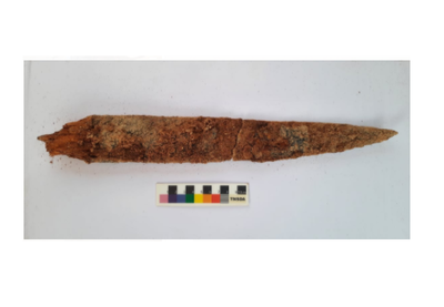
Iron dagger with wooden handle, skeletal remains found at Konthagai, India
The 40-cm-long weapon with a 6-cm-long wooden handle was found at a depth of 77 cm.
The sample will be sent to Beta Analytical Lab, Florida, USA, for exact dating.
An iron dagger with a wooden handle was found inside a burial urn unearthed at Konthagai village, which is part of the Keeladi cluster where the seventh phase of excavation is in full swing to establish the existence of urban civilisation in the Sangam era.
The second season of digging started in February at Konthagai where 25 burial urns have been unearthed so far and 11 of them have been opened, according to R. Kaviya, one of the four Site Archaeology Officers.
These urns measure 95 to 105 cm in height with a circumference of 80 cm. Some of the urns contained iron weapons, shaped like knives, and spears and small terracotta vessels.
The latest, a 40-cm-long iron dagger with a 6-cm-long wooden handle was found at a depth of 77 cm. The urn filled with soil sediment had the five-cm-thick dagger, associated with femur bones, a skull and an offering pot.
It is a type used by warriors belonging to the Sangam period, contemporary to Keeladi dating, according to R. Sivanandam, Director of Keeladi Excavations.
This was the first time that they had stumbled upon a weapon with a wooden handle, and it would be very useful for exact dating of the evidence found so far, he said.
Though extremely fragile, the wooden handle was preserved in rare natural phenomena and collected carefully in foil covers. The sample would be sent to Beta Analytical Lab, Florida, the USA, for an exact dating, added Mr. Sivanandam, who is also the Commissioner (FAC), Department of Archaeology.
25 burial urns have been unearthed so far in Keeladi
The skeleton samples were handed over to experts at Madurai Kamaraj University, where a DNA testing laboratory is coming up.
Ms. Kaviya said the urn was found with a disturbed lid. The broken portion of the lid was retrieved inside the urn at a depth of 80 cm.
There was a possibility that the broken portion of the urn lid fell on the iron dagger, as two urn lid pieces were found on either side of the dagger, which was also damaged.
The Keeladi excavations are being carried out by the Archaeological Survey of India under the supervision of Minister for Industries Thangam Thennarasu and B. Chandramohan, Principal Secretary, Tourism, Culture & Religious Endowments Department.
Scientists Present 20,000-Year-Old Woolly Rhinoceros Unearthed in Siberia, Report Says
Aided by melting permafrost, long-extinct creatures such as the woolly rhino are being uncovered and casting new light on prehistoric eras. Around 20,000 years ago, a young woolly rhinoceros went about its day like usual in the icy region of what is now northern Siberia.
Foraging for food, something likely went fatally wrong for the young animal as it drowned in the Tirekhtyakh River or a nearby area of water.
Fast forward a few millennia and that woolly rhino’s tragic fate that day has become a pathologist’s dream come true. Aided by the melting permafrost from a trend of rising temperatures, long-extinct creatures such as the woolly rhino are being uncovered and casting new light on unknown, prehistoric eras.
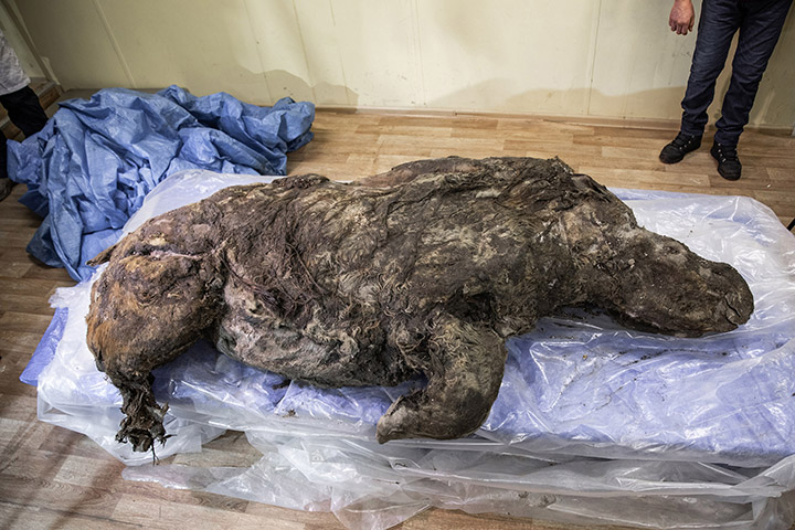
An exceptionally well-preserved woolly rhino with its last meal still intact found in Arctic Yakutia. The juvenile rhino with thick hazel-coloured coat was 3 to 4 four years old when it died at least 20,000 years ago; its horn was found next to the carcass
Permafrost is a permanently frozen layer of soil that has been frozen for a long period of time, sometimes several thousand years.
The ancient carcass was discovered by a local farmer in Yakutia, Siberia, in August 2020, about 15,000 years after the wooly rhinoceros is believed to have gone extinct. The fossil was found with a fully intact fur coat, hooves, and internal organs, giving scientists a crucial puzzle piece on the anatomy, behaviors and life of the creatures.
This photo taken in Aug. 2020 shows the carcass of a woolly rhino, taken in Yakutia, The well-preserved carcass with most of its internal organs still intact was released by permafrost in August and scientists hope to transport it to the lab for studies next month.
Video from the fossil excavation was recently shared online by The Siberian Times. As the footage shows, paleontologists took extensive care to keep as much of rhino’s structure preserved. Their successes resulted in 80% of the specimen remaining intact, a breakthrough effort.
“The young rhino was between 3 and 4 years old and lived separately from its mother when it died, most likely by drowning,” paleontologist Valery Plotnikov told The Siberian Times.
Plotnikov, who works with the Russian Academy of Sciences, added that the gender of the wooly rhino is still unknown and radiocarbon analysis is needed to confirm the general time range when the rhino likely lived.
Found next to the rhino carcass was the young animal’s horn, an exceptional find, according to Plotnikov, because of how quickly the cartilage usually decomposes. Markings on the horn, he said, also shed more light on how the species used it for food.
The recently found frozen creature isn’t the first woolly rhino to be discovered in the area, as another ice-preserved specimen was unearthed in 2015. That rhino, nicknamed Sasha, was the first baby woolly rhino ever discovered and is believed to have roamed the region around 34,000 years ago.
Like the recently discovered rhino, Sasha was found with a fully-intact coat of wool and was also believed to have drowned. However, unlike the recent rhino, Sasha’s fur was strawberry blonde and the carcass lacked the front horn.
Historically high temperatures in the normally icy region have revealed perfectl -preserved fossils that had previously been buried under thousands of years of thick ice. This past summer, shortly before the remains were found, record-high temperatures were recorded in towns around the Arctic Circle.
“Temperatures soared 10 degrees Celsius (18 degrees Fahrenheit) above average last month in Siberia, home to much of Earth’s permafrost, as the world experienced its warmest May on record,” according to the European Union’s climate monitoring network.
AccuWeather Meteorologist Maura Kelly wrote in June that the prolonged period of heat triggered the melting of permafrost across northern Siberia.
“The record-high temperatures in May followed a record-breaking start to 2020 across Russia,” she wrote at the time in a story for AccuWeather.com. “Temperatures from January to April across the country averaged about 6 degrees Celsius (11 degrees Fahrenheit) above normal.”
Recently, the new woolly rhino fossil was transported to scientists for further tests thanks to newly built ice roads in Yakutia. In the coming years, the slowly receding ice layer is sure to unveil even more frozen puzzle pieces, continually assembling the jigsaw of our ancestors and generations of previously hidden life.
Archaeologists unearth 1st Jerusalem evidence of quake from Bible’s Book of Amos
Books of Amos and Zechariah in the Old Testament describe an earthquake that rocked the city of Jerusalem about 2,800 years ago and archaeologists have now found the first evidence of the biblical event.
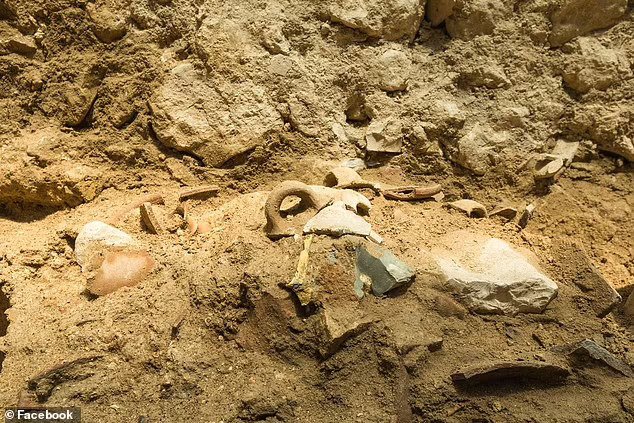
The Israel Antiquities Authority’s (IAA) excavations in the City of David National Park uncovered a layer of destruction during excavations, which consists of collapsed walls, broken pottery and bits and pieces of other goods.
Researchers say that since there was no signs of fire or an ancient conquest the destruction had to have been caused by an earthquake that hit Israel during the 8th century BC.
The Israel Antiquities Authority’s (IAA) excavations in the City of David National Park uncovered a layer of destruction during excavations, which consisted of collapsed walls, broken pottery and bits and pieces of other goods
Some evidence of the event has been found in surrounding areas, but this is the first time archaeologists can prove it hit the major city.
In the book of Amos, the passage reads: ‘The words of Amos, a sheep breeder from Tekoa, who prophesied concerning Israel in the reigns of Kings Uzziah of Judah and Jeroboam son of Joash of Israel, two years before the earthquake.
‘And the Valley in the Hills shall be stopped up, for the Valley of the Hills shall reach only to Azal; it shall be stopped up as it was stopped up as a result of the earthquake in the days of King Uzziah of Judah,’ reads another passage in Zechariah, recalling the event some 200 years later, to suggest how strong of a collective memory it left.’
Among the artefacts, archaeologists found were fragments of pottery, some nearly intact that they could be put back together, and small tables, The Jerusalem Post reports.
Since the artefacts were discovered deep into the excavation site, experts say residents had to have built on top of the ruins following the earthquake, which preserved traces of the event that occurred.
Researchers say that since there was no signs of fire or an ancient conquest the destruction had to have been caused by an earthquake that hit Israel during the 8th century BC. Pictured are collapsed walls that ruin of the event
Among the artefacts, archaeologists found were fragments of pottery, some nearly intact that they could be put back together, and small tables
IAA excavation directors Dr. Joe Uziel and Ortal Chalaf said in a statement: ‘When we excavated the structure and uncovered an 8th century BCE layer of destruction, we were very surprised because we know that Jerusalem continued to exist in succession until the Babylonian destruction, which occurred about 200 years later.
‘We asked ourselves what could have caused that dramatic layer of destruction we uncovered.
‘Examining the excavation findings, we tried to check if there is a reference to it in the biblical text.
‘Interestingly, the earthquake that appears in the Bible, in the books of Amos and Zechariah, occurred at the time when the building we excavated in the City of David collapsed.’
Another biblical find was discovered in Israel last month – a pottery fragment unearthed in Israel bears the name of the biblical judge ‘Jerubbaal,’ which was inked on the artefact 3,100 years ago
Another biblical find was discovered in Israel last month – a pottery fragment unearthed in Israel bears the name of the biblical judge ‘Jerubbaal,’ which was inked on the artefact 3,100 years ago.
Mentioned in the Hebrew bible, Jerubbaal was a military leader, judge and prophet whose story is recounted in chapters 6 to 8 of the Book of Judges.
The ceramic artefact was discovered in an archaeological excavation at Horbat al-Ra’i, near Kiryat Gat in Israel, which experts say was part of a small jug that carried precious liquids.
‘The name is written on the jug, Yarubaal, may allude to biblical Jerubbaal, also known as the judge Gideon ben (son of) Yoash, but we cannot be sure if he owned the inscribed vessel,’ the Israel Antiquities Authority shared in a statement.
World’s oldest-known coin mint identified in China
A team of researchers from Zhengzhou University, the Modern Analysis and Computer Center of Zhengzhou University and Peking University, all in China, has found evidence of what appears to be the oldest coin-minting operation ever uncovered.
Spatial distribution of the minting remains in the foundry’s excavation area: red dots: deposit with clay molds; green dots: deposits with fragments of finished spade coins (drone photograph by Z. Qu; figure by H. Zhao).
In their paper published on the Cambridge University site Antiquity, the group describes their discovery and study of coins and minting molds found at a dig site in Henan Province, China, and what they have learned about it.
Up until now, researchers have believed that the use of coins as a form of currency was first developed in Greece or Turkey.
Coins dug up in what is now modern Turkey, created and used by people of the Lydian Empire, have been dated as far back as 630 B.C. But there is still debate as to their true age due to the dating techniques used.
In this new effort, the researchers found coins in China in the same location as a minting facility, which left behind ashes that could be used for carbon dating—a very accurate means of dating the minting operation.
The coins and molds were found at a site identified as the ancient city of Guanzhuang, which was founded around 800 B.C.
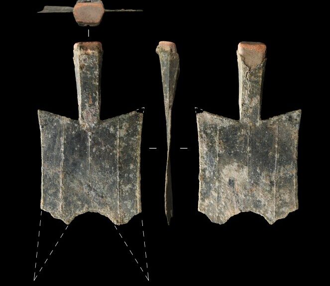
Items found by the researchers included multiple bronze, spade-shaped coins and the clay molds that were used to make them.
Testing of the ashes left by the fires used to melt the metal showed them to be approximately 2,600 years old, which would mean the facility was used to make coins as recently as 550 B.C. and as long ago as 640 B.C., making it the oldest known coin-making facility ever discovered.
Coin SP-1 (pictured) was found in such an excellent state of preservation that its complete shape could be reconstructed. Restored, it has a full length of 143mm, a thickness of 0.9mm, and an original weight of no less than 31g. It bears no inscriptions of its face value or where it was cast – as is typical of the earliest spade coins. Of the second spade coin discovered (Coin SP-2), only the handle and clay core survive.
The researchers suggest the facility was first used to make tools, weapons and other objects as early as 770 B.C. It took another century for the people there to start using their technology to create coins.
They also note that historians have still not agreed on the reason for the creation of currency in the form of coins; some suggest it made buying and selling things easier, while others believe it came about as a way for governments to collect taxes.
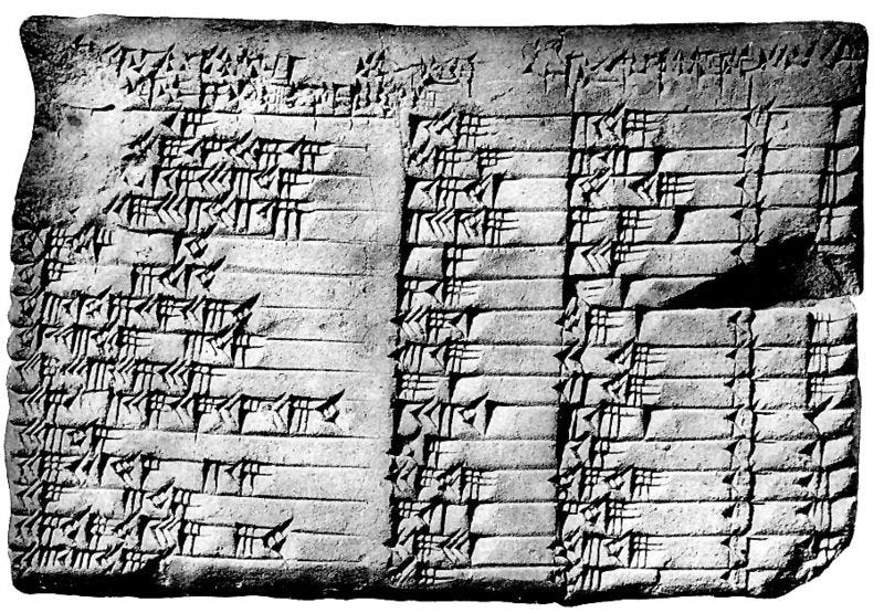
3,700-year-old Babylonian tablet rewrites the history of maths – and shows the Greeks did not develop trigonometry
Tucked away in a seemingly forgotten corner of the Istanbul Archaeology Museum, Daniel Mansfield found what may solve one of ancient math’s biggest questions. First exhumed in 1894 from what is now Baghdad, the circular tablet — broken at the centre with small perpendicular indentations across it — was feared lost to antiquity. But in 2018, a photo of the tablet showed up in Mansfield’s inbox.
Mansfield, a senior lecturer of mathematics at the University of New South Wales Sydney, had suspected the tablet was real. He came across records of its excavation and began the hunt. Word got around about what he was looking for, and then the email came. He knew what he had to do: travel to Turkey and examine it at the museum.
Hidden within this tablet is not only the oldest known display of applied geometry but a new ancient understanding of triangles. It could rewrite what we know about the history of mathematics, Mansfield argues. These findings were published Wednesday in the journal Foundations of Science.
It’s generally thought that trigonometry — a subset of geometry and what’s displayed on the tablet in a crude sense — was developed by ancient Greeks like the philosopher Pythagoras. However, analysis of the tablet suggests it was created 1,000 years before Pythagoras was born. Babylonian mathematics, which already holds a place of renown in the pantheon of ancient math, might’ve been more sophisticated than historians have given it credit for.
“The way we understand trigonometry harks back to ancient Greek astronomers,” Mansfield tells Inverse. “I like to think of the Babylonian understanding of right triangles as an unexpected prequel, which really is an independent story because the Babylonians weren’t using it to measure the stars, they were using it to measure the ground.”
Dr. Mansfield observes the tablet.
WHAT YOU SHOULD KNOW FIRST — Mansfield is no stranger to a pair of white gloves and following his mathematical curiosity. Years before discovering this latest tablet, dubbed Si.427, Mansfield was hot on the trail of another ancient Babylonian “document:” Plimpton 322. While the location of this artefact was known (it’s located at Columbia University) its true purpose was not.
Like Si.427, which dates back to roughly 1900 to 1600 BCE, Plimpton 322 is covered in geometric markings — riddles academics have tried to decipher for years. While the reigning theory was that these markings were a kind of teacher’s cheat code for Babylonian homework problems, Mansfield and colleagues were not convinced. In a 2017 paper, Mansfield and colleagues propose Plimpton 322 might be a kind of proto-trigonometry table of values — suggesting it predates the development of trigonometry as we know it today.
The Plimpton 322 clay tablet: it’s about the size of a postcard.
“A modern analogy would be to say that it contains a mix of elementary school problems alongside the unsolved conjectures of mathematics,” writes Mansfield in the new paper.
WHAT’S NEW — Now, Mansfield argues the discovery of Si.427 could confirm his Plimpton 322 hunch. In essence, Si.427 is argued to be a case study of how this proto-trig could be used in practice.
Si.427 is what’s known as a cadastral document. These are used to document the boundaries of land ownership. There are other examples on record, but Mansfield argues this tablet is the oldest known example from the Old Babylonian period — a range that stretches from 1900 BCE to 1600 BCE. On the tablet are legal and geometry details about a field that was split after some of it were sold.
This research suggests Plimpton 322 was used similarly: It might have been a surveyor’s cheat sheet, instead of a teacher’s. It’s possible Plimpton 322 was the theoretical solution to the practical problems a surveyor using Si.427 might have encountered.
“It’s a discovery that has come to us far outside our mathematical culture,” Mansfield says. “It seems new and fresh to us, even though it’s almost 4,000 years old.”
Using the principles of right triangles and perpendicular lines, ancient surveyors could evenly divide the land to avoid disputing neighbours.
WHY IT MATTERS — While these tablets are the kind of thing you might easily walk past on display in a museum, Mansfield said this discovery could actually have a huge implication for how we understand these ancient mathematics. Namely, it means mathematicians were working with so-called Pythagorean triples (trios of numbers that satisfy the infamous a^2+b^2 = c^2 equation) long before Pythagoras himself was even born. It also helps answer a slightly less academic question: How do you evenly divide up disputed land?
“This is from a period where land is starting to become private — people started thinking about the land in terms of ‘my land and your land,’ wanting to establish a proper boundary to have positive neighbourly relationships,” Mansfield explains in a statement.
“And this is what this tablet immediately says. It’s a field being split, and new boundaries are made.”
HOW DOES IT WORK? — As for how triangles sketched in clay translate to farmer’s fields, it all comes down to perpendicular lines. Essentially, surveyors would choose two Pythagorean triples (which were inherently right triangles) and extend the boundary line of the resultant rectangle by eye to create true perpendicular lines that spread across the entire field.
“This proves that our Babylonian surveyor had a solid theoretical understanding of the geometry of rectangles and right triangles and used it to solve practical problems,” Mansfield says in the video.
Extending the boundary of these triangles allowed surveyors to create incredibly straight lines without manually measuring or laying them out beforehand.
There are also instances of resizing these triangles to better fit the physical shape of the field at hand, which surveyors would’ve liked done by referencing a table of trig values like Plimpton 322, the study suggests. This table would’ve been a comprehensive list of Pythagorean triples and the steps to resizing them.
WHAT’S NEXT — This discovery may have laid to rest one ancient math mystery, there’s still plenty more where that came from, Mansfield says.
“Ancient mathematics is not as sophisticated as modern mathematics,” he says. “But sometimes you want to simple answers instead of sophisticated ones.”
He’s not “just talking about how mathematics students want their exams to be.” The advantage of a simple approach is its quickness — and Mansfield wants to examine whether or not this approach has any real-world applications.
“This approach might be of benefit in computer graphics or any application where speed is more important than precision,” he says.
Abstract: Plimpton 322 is one of the most sophisticated and interesting mathematical objects from antiquity. It is often regarded as teacher’s list of school problems, however new analysis suggests that it relates to a particular geometric problem in contemporary surveying.
Iraq says the US returning 17,000 looted ancient treasures
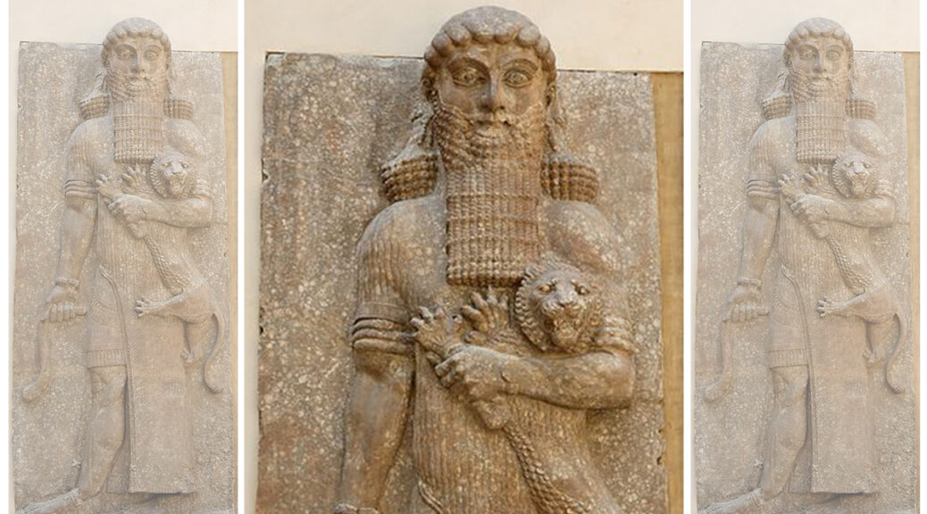
Gilgamesh was a major hero in ancient Mesopotamian mythology and the protagonist of the Epic of Gilgamesh
Next month, museum-goers in Iraq are in for a surprise. Eighteen years after it was looted from the city, a clay tablet bearing the Epic of Gilgamesh, regarded as one of the world’s oldest surviving pieces of literature, is set to return to the place of its birth.
Iraq Tuesday reclaimed more than 17,000 ancient artefacts looted and smuggled out of the country after the US invasion in 2003, reported The New York Times.
About 12,000 of the returned artifacts had been housed in the Museum of the Bible in Washington DC and 5,381 had been held by Cornell University. Both institutions have been pulled up by US authorities in the past for holding artifacts that were not acquired through appropriate means.
Artifacts seized by the U.S. government and returned to Iraq are displayed at the Ministry of Foreign Affairs in Baghdad, Iraq August 3, 2021.
Iraqi culture and foreign ministries disclosed to the NYT that US authorities had reached an agreement with Iraq to return items seized from dealers and museums in the US. Iraqi Prime Minister Mustafa al-Kadhimi brought back the artifacts on his plane, after making an official visit to the US last week.
After 1991, when the Iraqi government lost control of parts of southern Iraq following the first Gulf War, widespread looting occurred at historical sites. The looting continued after the US-led invasion in 2003 — the year that also witnessed the end of the Saddam Hussein regime.
Many artefacts were also smuggled or destroyed by the Islamic State of Iraq and Syria (ISIS) militants during the period between 2014 and 2017 when it controlled some parts of Iraq.
The Gilgamesh tablet
The Gilgamesh tablet is a prized and much-anticipated retrieval.
The 3,500-year-old clay tablet bearing the Epic of Gilgamesh is considered one of the world’s first pieces of notable literature. The epic is believed to predate Homer’s Iliad by 1,500 years and is one of the beloved tales of Mesopotamia — present-day Iraq.
The Epic of Gilgamesh is a 3,500-year-old Sumerian tale considered one of the world’s first pieces of literature
The epic is based on the many adventures of the handsome athletic king of Uruk, Gilgamesh (2900–2350 BC).
Many of the other clay tablets and seals that have been returned by the US also are linked to Mesopotamia — one of the world’s earliest civilisations — and even to Irisagrig, a lost ancient city.
The tablet will return to Iraq in September after legal procedures are wrapped up, Iraq’s Culture Minister Hassan Nadhem told Reuters. Speaking on the cultural value of the artifacts, he told The New York Times: “This is not just about thousands of tablets coming back to Iraq again — it is about the Iraqi people.”
Back to places of origin
In 2013, the US Justice Department urged Cornell University to give back thousands of ancient tablets believed to have been looted from Iraq in the 1990s, according to the Los Angeles Times.
In 2019, US authorities seized the Gilgamesh tablet displayed at the Washington museum after it was revealed to have been smuggled, auctioned and sold to an art dealer in Oklahoma.
An American antiquities dealer had bought the tablet from a London-based dealer in 2003, the US Department of Justice said in a statement last week.
Australia, too, in a statement last week, announced it would return 14 works of art, worth a combined $3 million, to the Indian government.
Has the ‘Lost City of the Gospels Finally Been Found?
Excavations this summer on the northeastern shore of the Sea of Galilee have uncovered what may be evidence of the ancient city, Bethsaida-Julias, home to three of Jesus’ apostles: Peter, Andrew, and Philip (John 1:44; 12:21). It was also a location for Jesus’ ministry (Mark 8:22) and is near the land where Luke’s gospel reports the miracle of Jesus feeding five thousand people with only five loaves of bread and two fish (Luke 9:10-17).
The excavations were conducted under the auspices of the Kinneret Institute for Galilean Archaeology at Kinneret College (Israel) and directed by Dr. Mordechai Aviam together with Dr. R. Steven Notley from Nyack College (New York), who is the excavation’s academic director. Students and faculty from Nyack College joined volunteers from the U.S. and Hong Kong to excavate for two weeks in July.
Because of its importance in the Christian tradition, scholars have tried to identify the site. Historical sources suggest that it was located near the Jordan River, in the large valley between Galilee and the Golan Heights.
For the last 30 years, popular opinion identified Bethsaida with the site of et-Tel where archaeologists found a settlement in the late Hellenistic (2nd cent. BCE) and Roman periods (1st-2nd cent. CE), including two private houses. However, traces of the Greco-Roman developments reported by historical reports are lacking.
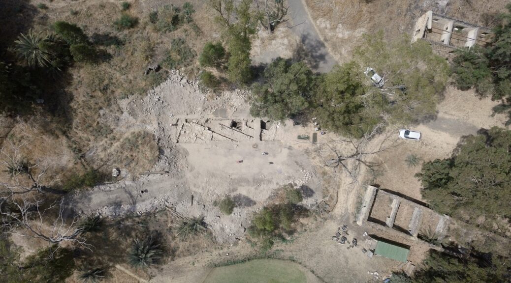
Now evidence has been discovered indicating that Bethsaida-Julias was located at another site, El Araj in the nature reserve of the Beteiha Valley on the shore of the Sea of Galilee.
Aerial of el-Araj showing the southern, western and northern walls of the Byzantine Church of the Apostles and inundated squares of previous seasons with Roman period remains.
Flavius Josephus, the first-century historian tells us that in 31 CE, Herod Philip, son of Herod the Great, transformed the Jewish fishing village of Bethsaida on the Kinneret Lake (Sea of Galilee) into a Greco-Roman polis (Ant. 18:28). As governor of the region, he renamed the city Julias, after Julia Augusta (née Livia Drusilla), mother of Roman Emperor Tiberius. Decades later, Josephus himself was responsible for fortifying the city’s defenses in preparation for the Jewish Revolt against Rome (66-70 CE). In 68 CE he was wounded in battle on the swampy marshlands near Julias (Life 399-403).
The Byzantine (4th-7th centuries CE) and Roman (1st-3rd centuries CE) period remains both point to el-Araj as the site of the city of Bethsaida-Julias. Under the Byzantine floor of a structure discovered during the first season were 30 coins that date to the 5th century CE.
It is possible that these walls are the remains of a monastery which was built around a church. Combined with the many gilded glass tesserae (stone or glass cubes that are used for mosaics) that were found in the first and second season, they indicate the existence of a wealthy and important church.
A Byzantine eyewitness, Willibald, the bishop of Eichstätt in Bavaria, visited the Holy Land in 725 CE, and describes a visit to a church at Bethsaida that was built over the house of Peter and Andrew. It may be that the current excavations have unearthed remains from that church.
Roman pottery that dates between the 1st – 3rd centuries was uncovered under the Byzantine level. A bronze coin of the late 2nd century CE and a beautiful silver denarius of the emperor Nero from the year 65-66 CE that reads “Nero, Caesar Augustus” were also found.
This alone could disprove speculation that there was no human presence at el-Araj in the Roman period. Furthermore, a Roman wall was discovered at a depth nearly 693 feet (211.16m) below sea level.
Adjacent to this wall was a large portion of mosaic flooring with a white and black meander pattern still attached to its original plaster and similar to other mosaics known from first-century sites around the lake.
Along with the discovery of clay bricks and ceramic vents (tubuli), which are typical to Roman bathhouses, these finds are evidence of urbanization.
Another important contribution from this season is the elevation of the remains. Most scholars agree today, following the excavators of Magdala that the level of the lake was 209 meters below sea level, and so they assume that the site of el-Araj was underwater until the Byzantine period.
The current excavations have demonstrated that the level of the lake was much lower than previously thought, and el-Araj most certainly was not underwater in the first century CE. Two geologists, Professor Noam Greenbaum from Haifa University and Dr. Nati Bergman from the Yigal Alon Kinneret Limnological Laboratory studied the layers of the site and pointed out that there are layers of soil which indicate that the site was covered with mud and clay that were carried by the Jordan River in the late Roman period, and which corresponds to a gap in material remains from about 250 CE to 350 CE, but in the Byzantine period, the site was resettled.
The El-Araj Excavations Project was made possible through the generous support of the Center for the Study of Ancient Judaism and Christian Origins, Nyack College, the Assemblies of God, and HaDavar Yeshiva (Hong Kong).
The excavations will continue next year, June 17-July 12, 2018 with the expectation to uncover more evidence for the Roman period settlement and the lost city of Jesus’ apostles!
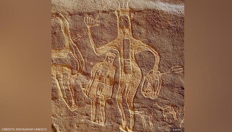
Saudi Arabia’s Hima cultural site added to UNESCO world heritage list
Hima, in the Gulf state’s southwest, is home to one of the largest rock art complexes in the world.
Najran, Saudi Arabia:
The sixth site in Saudi Arabia has been added to UNESCO’s world heritage list, the UN organisation announced on Saturday.
Hima, in the Gulf state’s southwest, is home to one of the largest rock art complexes in the world.
“New site inscribed on the UNESCO World Heritage List: cultural area of Hima, Saudi Arabia. Mabrouk (congratulations)!” UNESCO announced.
Hima features more than 34 separate sites including rock inscriptions and wells along the route of the ancient Arabian caravans.
The Bir Hima Saudi rock art region is famous for inscriptions like this written in languages ranging from ancient Greek and Aramaic-Nabatean to Thamudic, and South-Arabian
The kingdom has a “rich heritage (of) human civilisations. Efforts have borne fruit in making it known to the world,” it quoted him as saying.
SPA said Hima was a conduit for caravans on the trade and hajj routes to and from the southern parts of Arabia.
“People who passed through the area between pre-and post-historic times have left behind a substantial collection of rock art depicting hunting, wildlife, plants, symbols, and tools used at the time, as well as thousands of inscriptions,” the news agency said.
The site covers 557 square kilometres (215 square miles).
SPA said the wells in the area are more than 3,000 years old and were considered a vital source of fresh water in the vast desert of Najran province.
“They still serve freshwater to this day,” it added.
Other UNESCO sites in Saudi Arabia include rock art in the Hail region and historic Jeddah.
In 2019, Riyadh announced that for the first time it would grant tourist visas for those wishing to visit Saudi Arabia.
Previously, the country was open only to businessmen and Muslim pilgrims visiting the holy cities of Mecca and Medina.