Rare Ancient Child Burial Reveals 8,000-Year-Old Secrets of the Dead
Humanity has done a pretty good job of recording its collective history over the past two or three thousand years. Earlier time periods, though, are still very much shrouded in mystery. Now, a groundbreaking new archaeological discovery in Indonesia is revealing secrets from 8,000 years ago.
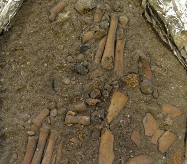
Entrance to Makpan cave, Alor Island, where the burial was discovered.
Archaeologists from The Australian National University have discovered an ancient child burial site located on Alor Island, Indonesia. While a funeral for a child is no doubt a morose and depressing event in any century, this unearthing is providing some invaluable insight on early mid-Holocene era cultural and burial practices.
Stunning burial practices unearthed
Articulated left foot (bottom left) and right foot (center) excavated in the ANU laboratory.
According to lead researcher Dr Sofia Samper Carro, it’s clear that the child was laid to rest with a formal ceremony of some kind. The research team estimates the child was between four and eight-years-old at the time of death.
“Ochre pigment was applied to the cheeks and forehead and an ochre-coloured cobblestone was placed under the child’s head when they were buried,” she says in a university release. “Child burials are very rare and this complete burial is the only one from this time period,”
“From 3,000 years ago to modern times, we start seeing more child burials and these are very well studied. But, with nothing from the early Holocene period, we just don’t know how people of this era treated their dead children. This find will change that.”
Of particular note is the fact that the child’s arms and legs appear to have been removed and stored elsewhere before the rest of the body was buried. This sounds rather odd from a modern perspective, but researchers say it isn’t wholly unprecedented.
“The lack of long bones is a practice that has been documented in several other burials from a similar time period in Java, Borneo and Flores, but this is the first time we have seen it in a child’s burial,” Dr Carro adds.
Why did ancient cultures remove arms and legs before burials?
The answer is probably lost to the sands of time, but researchers theorize some form of religion or spiritual belief is a likely explanation.
“We don’t know why long bone removal was practised, but it’s likely some aspect of the belief system of the people who lived at this time,” Carro adds.
While teeth examinations project the child as being around six to eight-years-old, the full skeleton appears to be closer to four or five-years-old.
“We want to do some further paleo-health research to find out if this smaller skeleton is related to diet or the environment or possibly to being genetically isolated on an island,” the lead researcher comments. “My earlier work from Alor showed adult skulls were also small.
These hunter-gatherers had a mainly marine diet and there is evidence to suggest protein saturation from a single food source can cause symptoms of mal-nourishment, which affects growth. However, they could have been eating other terrestrial resources such as tubers.”
“By comparing other adult burials we have found from the same time period with this child burial in a future project, we hope to build a chronology and general view of burial practices in this region from between 12,000 to 7,000 years ago which at the moment is still scant.”
The first-ever portrait of Jesus Christ in Israel Discovered, 70 ancient books hidden in a cave for nearly 2,000 years
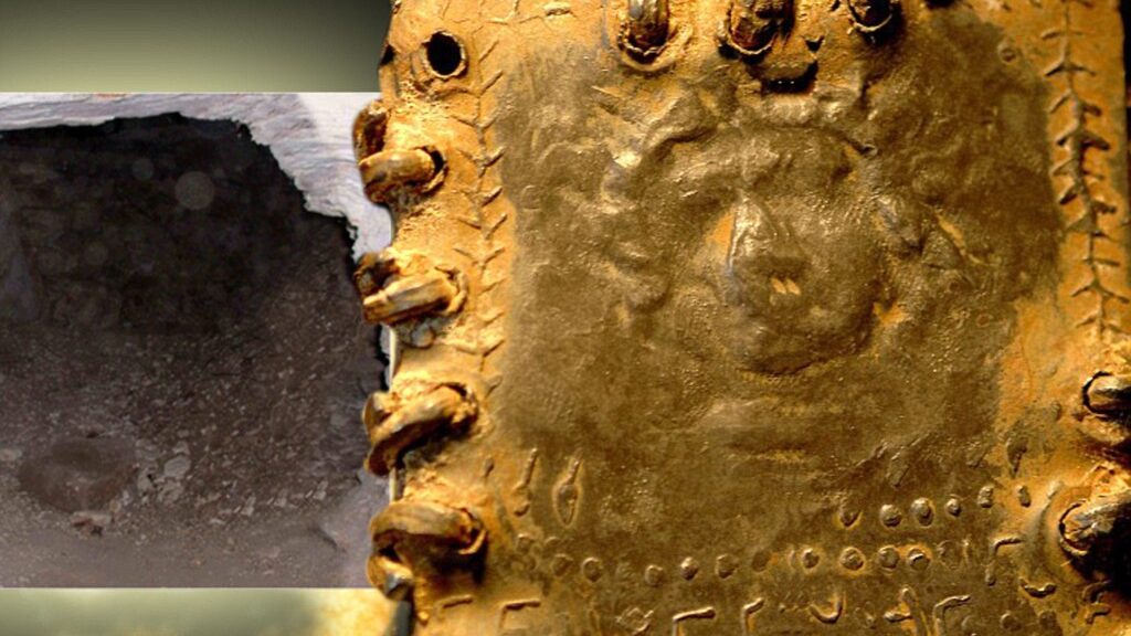
The image is eerily familiar: a bearded young man with flowing curly hair. After lying for nearly 2,000 years hidden in a cave in the Holy Land, the fine detail is difficult to determine. But in a certain light, it is not difficult to interpret the marks around the figure’s brow as a crown of thorns.
The extraordinary picture of one of the recently discovered hoards of up to 70 lead codices – booklets – found in a cave in the hills overlooking the Sea of Galilee is one reason Bible historians are clamouring to get their hands on the ancient artefacts.
If genuine, this could be the first-ever portrait of Jesus Christ, possibly even created in the lifetime of those who knew him.
Discovery: The impression on this booklet cover shows what could be the earliest image of Christ
The tiny booklet, a little smaller than a modern credit card, is sealed on all sides and has a three-dimensional representation of a human head on both the front and the back. One appears to have a beard and the other is without. Even the maker’s fingerprint can be seen in the lead impression. Beneath both figures is a line of as-yet undeciphered text in an ancient Hebrew script.
Astonishingly, one of the booklets appears to bear the words ‘Saviour of Israel’ – one of the few phrases so far translated.
The owner of the cache is Bedouin trucker Hassan Saida who lives in the Arab village of Umm al-Ghanim, Shibli. He has refused to sell the booklets but two samples were sent to England and Switzerland for testing.
An investigation has revealed that the artefacts were originally found in a cave in the village of Saham in Jordan, close to where Israel, Jordan and Syria’s Golan Heights converge – and within three miles of the Israeli spa and hot springs of Hamat Gader, a religious site for thousands of years.
Precious: This booklet shows what scholars believe to be the map of Christian Jerusalem
According to sources in Saham, they were discovered five years ago after a flash flood scoured away the dusty mountain soil to reveal what looked like a large capstone. When this was levered aside, a cave was discovered with a large number of small niches set into the walls. Each of these niches contained a booklet. There were also other objects, including some metal plates and rolled lead scrolls.
The area is renowned as an age-old refuge for ancient Jews fleeing the bloody aftermath of a series of revolts against the Roman empire in the First and early Second Century AD.
The cave is less than 100 miles from Qumran, where the Dead Sea Scrolls were discovered, and around 60 miles from Masada, scene of the last stand and mass suicide of an extremist Zealot sect in the face of a Roman Army siege in 72AD – two years after the destruction of the Second Temple in Jerusalem.
It is also close to caves that have been used as sanctuaries by refugees from the Bar Kokhba revolt, the third and final Jewish revolt against the Roman Empire in 132AD.
The era is of critical importance to Biblical scholars because it encompasses the political, social and religious upheavals that led to the split between Judaism and Christianity.
It ended with the triumph of Christianity over its rivals as the dominant new religion first for dissident Jews and then for Gentiles.
In this context, it is important that while the Dead Sea Scrolls are rolled pieces of parchment or papyrus containing the earliest-known versions of books of the Hebrew Bible and other texts – the traditional Jewish format for written work – these lead discoveries are in book, or codex, a form which has long been associated with the rise of Christianity.
The codices seen range in size from smaller than 3in x 2in to around 10in x 8in. They each contain an average of eight or nine pages and appear to be cast, rather than inscribed, with images on both sides and bound with lead-ring bindings. Many of them were severely corroded when they were first discovered, although it has been possible to open them with care.
The codex showing what may be the face of Christ is not thought to have been opened yet. Some codices show signs of having been buried – although this could simply be the detritus resulting from lying in a cave for hundreds of years.
Unlike the Dead Sea Scrolls, the lead codices appear to consist of stylised pictures, rather than text, with a relatively small amount of script that appears to be in a Phoenician language, although the exact dialect is yet to be identified. At the time these codices were created, the Holy Land was populated by different sects, including Essenes, Samaritans, Pharisees, Sadducees, Dositheans and Nazoreans.
One lucky owner: Hassan Saida with some of the artefacts that he says he inherited
There was no common script and considerable intermingling of language and writing systems between groups. Which means it could take years of detailed scholarship to accurately interpret the codices.
Many of the books are sealed on all sides with metal rings, suggesting they were not intended to be opened. This could be because they contained holy words which should never be read.
A Scientist Thinks These Ancient Roman Nails May Have Been Used To Crucify Jesus Christ
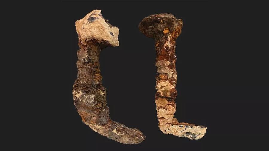
According to a new analysis, two corroded Roman-era iron nails which some have claimed pinned Jesus to the cross seem to have been used in an ancient crucifixion. The controversy about the origin of the nails was reignited by this study.
The two Roman-era iron nails are from an unmarked box delivered to Tel Aviv University; new research suggests they could be the two nails lost from the tomb of the Jewish high priest Caiaphas, who presided over the condemnation of Jesus.
The latest research indicates that the nails of the tomb of the Jewish high priest Caiaphas, who supposedly handed Jesus over for execution to the Romans for execution. Slivers of wood and bone fragments suggest they may have been used in a crucifixion.
The connection to Caiaphas and the new evidence did not completely show that the nails were used to crucify Jesus in Jerusalem in A.D. 33, Geologist Aryeh Shimron, the lead author of the study published in the journal Archaeological Discovery.
“I certainly do not want to say that these nails are from the crucifixion of Jesus of Nazareth,” Shimron told Live Science. “But are they nails from a crucifixion? Very likely, yes.”
Where did the nails originate?
One of the nails was purportedly found in one of the 12 ossuaries within Caiaphas’ tomb, while the other was found on the ground nearby.
Israel Hershkovitz, a renowned anthropologist at Tel Aviv University, received the nails in an unmarked box from the collection of Nicu Haas, an Israeli anthropologist who died in 1986. According to the Israel Antiquities Authority (IAA), Haas obtained them from a tomb excavated in the 1970s, decades before the Caiaphas tomb was discovered, according to Haaretz.
But the IAA doesn’t know which tomb the nails came from, and no records of their provenance have ever been found. In a controversial 2011 documentary called “The Nails of the Cross,” however, filmmaker and journalist Simcha Jacobovici suggested the nails were those lost from the Caiaphas tomb — and that the high priest may have been so overcome with guilt about the crucifixion of Jesus that he kept the nails as a memento.
Haaretz reported that some scholars, though no names were given, have called the latest research highly speculative. But Shimron, a geologist based in Jerusalem who’s retired from the Israel Geological Survey, said the new study gave weight to the documentary’s ideas. Shimron has not studied the two nails that are the subject of Jacobovici’s 2011 documentary before now, though he was involved in a 2015 study tied to another of Jacobovici’s controversial documentaries on the archaeology of Jesus.
The nails are long enough to have been driven through a person’s palms — and the fact that they are bent upward is consistent with crucifixion.
Workers widening a road discovered the first-century “Caiaphas” tomb in 1990 in a neighbourhood in the southeast of Jerusalem. The tomb contained 12 ossuaries —– one marked with the name “Qayafa” and another, ornately decorated with motifs of flowers, marked with the Aramaic name “Yehosef Bar Qayafa,” or “Joseph son of Caiaphas” in English. Most archaeologists now accept that the tomb was used to bury the first-century high priest Caiaphas and his family, the study said.
Caiaphas, who is is mentioned several times in both the Christian New Testament and history of the Jews written in the late first century by Flavius Josephus, presided over a sham trial of Jesus for blasphemy, after which Jesus was handed over to the Roman governor Pontius Pilate for execution, according to the Gospel of Matthew. The execution was reportedly carried out on Friday, April 3, 33, when Jesus was nailed to the cross — a common Roman method of capital punishment.
The two nails discovered at Tel Aviv University match the chemical signature of the ossuaries in the Caiaphas tomb and have traces of an unusual fungus found there.
Jerusalem tomb
In the latest study, Shimron and his co-authors compared samples from the two nails with sediments from the ossuaries in the Caiaphas tombstone chests used to hold the bones of people after they had decayed for about a year on a rock shelf. It found that not only did the physical and chemical signatures of the nails and the ossuaries match, but they also seemed to be unique.
For example, the ratios of isotopes of carbon and oxygen — variants of these elements — in both sets of samples suggested they both came from an abnormally humid environment, and they both had significant “flowstone deposits” —– layers of calcite carbonate formed by flowing water.
These findings match the conditions in the Caiaphas tomb, which is located near an ancient aqueduct and often would have been flooded by its overflow. The researchers also found evidence on both the nails and the ossuaries of a specific fungus — an unusual type of yeast — that grows only in very damp conditions and has been found in no other tomb in Jerusalem. “I think the nails came from that tomb,” Shimron said.
Their analysis of the nails with an electron microscope also found slivers of wood on the nails, which they recognized as cedar, and tiny fragments of bone —– unfortunately now fossilized. Those discoveries heightened the possibility that the nails came from crucifixion, but they did not prove it, Shimron said.
Electron microscopy confirmed the two nails contained tiny bone fragments.
Mysterious nails
The IAA says their records show that two iron nails were also found in the Caiaphas tomb — one inside an unmarked ossuary and another on the ground near the ornate ossuary, possibly where it fell when it was disturbed by tomb robbers — but they were later lost.
The excavator of that tomb suggested they might have been used to scratch inscriptions on the ossuaries, but that idea was never investigated, Shimron said. The new study indicated the nails from Tel Aviv University were indeed those lost from the Caiaphas tomb, despite the IAA’s denial, he said.
According to the theory presented in Jacobovici’s documentary, they might have been buried with Caiaphas because crucifixion nails were thought to be magical — a belief noted in ancient Jewish writings. And because Caiaphas is only known for his role in the crucifixion of Jesus, it’s possible that the nails are linked with that event — although it can only be a supposition, Shimron said.
Hershkovitz, who still has possession of the two nails, told Live Science he was not convinced by the latest study, but he did not rule out the possibility that the nails came from the Caiaphas tomb. The nails are long enough to have been used on a person’s hands in a crucifixion, and they are bent upward at the end, — perhaps to prevent the hands being lifted off the cross, he said.
But the presence of bone fragments did not prove the nails were from a crucifixion, because bones from the tomb may have stuck to the nails. “Ossuaries are full of human bones,” he said.
Still, “there is a possibility — and we have to keep an open mind for every possibility, as scientists,” Hershkovitz said.
Female warrior was buried in the ‘riding position’ as if on a horse journeying into the afterlife 2,400 years ago
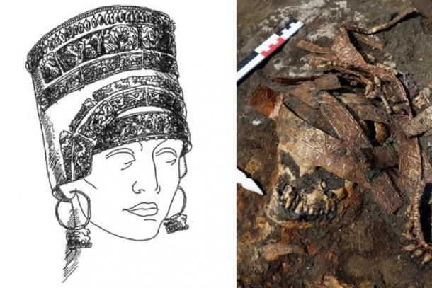
The burial of the Amazon with a headdress made of precious metal dated back to the second half of the 4th century BC was found by the members of the Don expedition of IA RAS during the examination of the cemetery Devitsa V of Voronezh Oblast.
The plate of the head dress (stlengis). The barrow №9 of the cemetery Devitsa V.
This is the first-ever found in Middle Don river, and well preserved ceremonial headdress of a rich Scythian woman, earlier archaeologists found only fragments of such headdresses. Valerii Guliaev, the head of Don expedition, announced the first results of the examination on the 6th of December at the session of Academic Council of IA RAS.
“Such headdresses have been found a bit more than two dozen and they all were in “tzar” or not very rich barrows of the steppe zone of Scythia. We first found such headdress in the barrows of the forest-steppe zone and what is more interesting the headdress was first found in the burial of an Amazon”, says Valerii Guliaev.
Cemetery Devitsa V which was called so after the name of the local village has been known since 2000s. It consists of 19 mounds part of which is almost hidden as this region is an agricultural zone which is currently ploughed. Since 2010 the site has been studied by the specialists of the Don expedition of IA RAS.
By the time of the excavation works the barrow №9 of the cemetery Devitsa V was a small hill of 1 m height and 40 m in diameter. Under the centre of the mound, the archaeologists found the remains of the tomb where the narrow entrance-dromos from the eastern side led to. In ancient times the tomb was covered by oak blocks which were laid crisscross and rested on 11 strong oak piles. The grave pit was surrounded by the clay earthwork taken from the ground during the construction of the grave.
One was a matriarch aged between 45 and 50 who was buried wearing her decorative Scythian ceremonial headdress known as a Kalaf with amphora-shaped pendants
In the barrow four women of different age were buried: two young women of 20-29 years old and 25-35 years old, a teenage girl of 12-13 years old and a woman of 45-50 years old. The burial was made simultaneously as one of the piles supported the floor of the tomb was in the dromos and completely overlaid the entrance so that it would be absolutely impossible to overtake it during next burials.
The burial was robbed in ancient times. The robbers broke into the tomb from the north when the floor had already fallen and the sepulchre was buried i.e. in 100 or 200 years after the barrow was filled. However, only northern and eastern parts of the tomb had been robbed where there were the remains of the teenager and one of the young women.
Apart from the spread remains we found in the northern part of the pit more than 30 iron arrowheads, an iron hook in the shape of a bird, fragments of horse harness, iron hooks for hanging harness, iron knives, fragments of moulded vessels, multiple animals’ bones. In filling the robbers’ passage the broken black lacquer lacythus with red-figure palmette dated back to the second –third quarter of the 4th c BC was found.
At the southern and western wall, there were two untouched skeletons laid on the wooden beds covered by grass beddings. One of them belonged to a young woman buried in a “position of a horseman”. As the researches of the anthropologists have shown to lay her in such way the tendons of her legs had been cut. Under the left shoulder of a “horsewoman”, there was a bronze mirror, on the left, there were two spears and on the left hand, there was a bracelet made of glass beads. In the legs, there were two vessels: a moulded cassolette and a black lacquer one hand cantharos which was made in the second quarter of the 4th c BC.
The 2,400-year-old female warrior was discovered at the Devitsa V ancient necropolis in Russia’s Voronezh region
The second buried was a woman of 45-50 years old. For the Scythian time, it was a respectable age as the life expectancy of a woman was 30-35 years old. She was buried in a ceremonial headdress, calathos, the plates of which were preserved decorated with the floral ornament and the rims with the pendants in the shape of amphorae.
As the researches have shown the jewellery was made from the alloy where approximately 65-70% was gold and the rest is the pollution of copper, silver and a small per cent of iron. This is quite a high percent of the gold for Scythian jewellery which was often made in the workshops of Panticapaeum from electrum, the alloy of gold and silver whereas the gold could be approximate of 30%.
Several vessels were found at the burial site including a black lacquer one-handed kanfar (left), a black lacquer ariballic lekif with red-figured palmette (centre) and a molded incense burner (right)
A giant bronze hand mirror the size of a frying pan (left) and iron spearheads (right) were also found buried at the site
“Found calathos is a unique find. This is the first headdress in the sites of Scythian epoch found on Middle Don and it was found in situ on the location on the skull. Of course, earlier similar headdresses were found in known rich barrows of Scythia. However, only a few were discovered by archaeologists.
They were more often found by the peasants, they were taken by the police, landowners and the finds had been through many hands when they came to the specialists. That is why it is not known how well they have been preserved. Here we can be certain that the find has been well preserved”, noted Valerii Guliaev.
Along with the older woman an iron knife was laid wrapped into a piece of fabrique and an iron arrowhead of quite a rare type, tanged with a forked end. These finds and also many details of the weapon and horse harness allow suggesting that the Amazons, women-warriors whose institution was in the Scythian epoch among Iranian nomadic and semi-nomadic tribes of Eastern Europe, were buried in this barrow. Such horsewomen probably were cattle, belonging and dwelling guardians while the men went to long-term warpaths.
“The Amazons are a common Scythian phenomenon and only on Middle Don during the last decade our expedition has discovered approximately 11 burials of young armed women. Separate barrows were filled for them and all burial rites which were usually made for men were done for them. However, we come across burials with four Amazons of such different age for the first time”, said Valerii Guliaev.
The burial was made in autumn at the end of the warm period. The researches done by paleozoologists of IA RAS helped to figure it out. In the grave pit, the bones of six-eight months old lamb were found which some time ago had been in a bronze cooking pot dag into the ground in the centre of the grave.
The robbers took the pot which was of great value and the bones greened from being rested in a bronze dish for a long time had been thrown away. Since the sheep usually lamb in March-April, it was concluded that the burial which the barrow had been filled for was done not later than November.
The finds in the burial have raised questions for scientists who still do not have any answers.
“We have come across an enigma: we have two women in their prime of life, one is a teenager and another is a woman quite old for the Scythian epoch. It is not clear how they could die at the same moment. They do not have any traces of bones injuries. These women’s bones have been spread. There are some marks of tuberculosis and brucellosis, but these illnesses cannot cause death simultaneously. That is why we still cannot understand what the cause of death was and why four women of different age were buried at the same time”, asks Valerii Guliaev.
Provided by Institute of Archaeology of Russian Academy of Sciences
“Dog is a man’s best friend” is the common saying. For thousands of years, dogs have been our companions for hunting, friendship, war, and many more. Dogs have managed to keep up with us humans and have now become ‘a mans best friend’. This could largely be down to a dog and their diet, which is why dog owners are quite particular when it comes to purchasing food for their companions. It’s become a regular activity for pet owners to get online and view recommended foods, such as pet food exposed, and others before choosing the right food for them! In modern times this has been largely reduced down to friendship and some may say our modern dogs lead a spoilt life of luxury, whether that is getting them decorative collars or procuring an orthopedic bed for dogs to help keep their joints healthy. There has been evidence that dogs have been kept as pets as far back as Ancient Egypt, with the finding of jeweled dog collars. But how far back exactly can the roots of our companionship with dogs be traced?
Science Magazine reports that evolutionary biologist Greger Larson of the University of Oxford, paleogenomicist Pontus Skoglund of the Francis Crick Institute, and their colleagues analyzed the genomes of more than 2,000 dogs who lived in Europe, Siberia, and the Near East as early as 11,000 years ago.
Libyan rock art that may date back 7000 years depicts a hunter and his dog.
“This is a very interesting research,” notes the archaeogeneticist Wolfgang Haak at the Max Planck Institute for Human History Sciences. “We’re finally starting to see how the dog story and the human story match up.”
One of the main enigmas of domestication were dogs. Scientists still have not figured out when or where they appeared, much less how or why they emerged, after decades of studies.
A 2016 study concluded that dogs may have been domesticated twice, once in Asia and once in Europe or the Near East, but critics said there wasn’t enough evidence to be sure.
A few years later, researchers reported signs of dogs in the Americas as early as 10,000 years ago, yet those canines appear to have vanished without a genetic trace. Other studies have found evidence of ancient dogs in Siberia and elsewhere, but scientists don’t know how they got there or how they’re related.
To fill in some of the blanks, two big names in dog and human genetics teamed up: Greger Larson, an evolutionary biologist at the University of Oxford, and Pontus Skoglund, a paleogenomicist at the Francis Crick Institute. Larsen, Skoglund, and colleagues sifted through more than 2000 sets of ancient dog remain dating back nearly 11,000 years from Europe, Siberia, and the Near East. In the process, they added 27 ancient dog genomes to the five already on record. They then compared those with the genomes of 17 humans living in the same places and times as the dogs.
The dog DNA alone revealed some surprises. As early as 11,000 years ago, there were already five distinct dog lineages; these gave rise to canines in the Near East, northern Europe, Siberia, New Guinea, and the Americas, the team reports today in Science. Because dogs had already diversified so much by that time, “domestication had to occur long before then,” Skoglund says. That fits with archaeological evidence: The oldest definitive dog remains come from Germany about 15,000 to 16,000 years ago.
Remarkably, pieces of these ancient lineages are still present in today’s pooches. Chihuahuas can trace some of their ancestries to early American dogs, for example, whereas Huskies sport genetic signatures of ancient Siberian dogs, the team found. “If you see a bunch of different dogs in a dog park,” Skoglund says, “they may all have different ancestries that trace all the way back 11,000 years” (see figure below).
Today’s dogs can trace their ancestry to canines that lived up to 11,000 years ago.
When the researchers compared their dog DNA with modern and ancient wolf DNA, they got another surprise. Most domesticated animals pick up genetic material from their wild relatives-even after domestication-because the two species often live in close proximity and can still mate (think pigs and wild boars). But dogs show no such “gene flow” from wolves. Instead, the wolves gained new DNA from the dogs-a one-way street.
Larson chalks this up to the intimate relationship between dogs and humans. If your pig or chicken becomes a bit wilder thanks to an infusion of feral DNA, it doesn’t matter, because you’re going to eat them anyway, he explains. But dogs that go native make bad guards, hunting companions, and friends. “If you’re a dog and you have a bit of wolf in you, that’s terrible,” Larson says. People will “get rid of the dog.”
The wolf-dog analysis also suggests dogs evolved only once, from a now-extinct wolf population. Still, Larson, who led the 2016 study on multiple domestication events, says more data are needed to seal the deal.
Then the scientists brought humans into the mix. They selected human DNA samples from the same places and eras for which they had ancient canine DNA and traced the genetic history of each. “It’s like you have an ancient text in two different languages, and you’re looking to see how both languages have changed over time,” Skoglund says.
In many places, the team found a strong overlap between human and dog genomes. For example, farmers and their pups in Sweden about 5,000 years ago both trace their ancestry to the Near East. This suggests early farmers took their dogs with them as agriculture spread throughout the continent. “Writ large, as humans moved, they moved with their dogs,” Larson says.
But sometimes the stories didn’t match up. Farmers in Germany about 7000 years ago also came from the Near East and also lived with dogs. But those animals seem more similar to hunter-gatherer pups, which came from Siberia and Europe.
That suggests many early migrants adopted local dogs that were better adapted to their new environment, Haak says. The benefits were many, adds Peter Savolainen, a geneticist at the Royal Institute of Technology and an expert on dog origins. “They were cute. You could use them. You could even eat them.”
Savolainen calls the study “very thorough,” and adds it’s “fantastic” that the researchers were able to bring together so many data. But he has long argued that dogs arose in Southeast Asia and says the work is incomplete without samples from that corner of the globe. “Without those, you could be missing an important part of the picture.”
For now, Larson says his team is analyzing “a ton” of wolf and dog genomes. He and his colleagues have also begun to look at ancient skull shape and genetic markers that could give clues to what early dogs looked like. Whatever he finds, he’s counting on being surprised. “We have to expect the unexpected,” he says, “because that’s all ancient DNA ever gives us.”
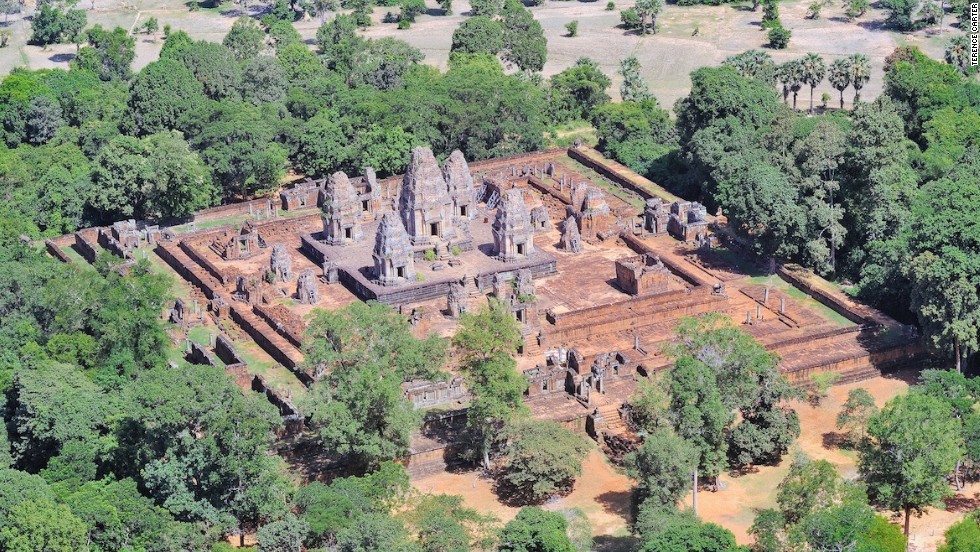
Sprawling Remains of Ancient Cities Discovered Beneath Cambodia’s Jungle
Every year, hundreds of thousands of tourists from around the world flock to visit the famed Angkor Wat temple in Cambodia. However, as exploration has uncovered evidence of mediaeval settlements under the jungle, it suggests that there will soon be new places to explore.
To shed new light on the society behind the world’s largest religious complex, researchers used laser technologies. Although the analysis has been ongoing for many years, the new findings uncover the sheer scale of the Khmer Empire’s urban sprawl and temple complexes to be significantly bigger than was previously thought.
Damian Evans and colleagues say they find evidence of extensive networks circling the colossal stone temple complex at Angkor Wat by using high-tech lasers to search the Cambodian jungle.
In 2012, the airborne Lidar system revealed a long-forgotten urban landscape in the jungle of Cambodia. The new research now reveals the sheer size of the ancient cities
Evans said their findings could further our understanding of Khmer culture and throw into question traditional assumptions about the 15th-century decline of the empire. Evans said a laser technology known as lidar was used to create precise maps of ancient networks that left only vague traces – invisible to the naked eye – in the landscape surrounding the temples.
‘You could be standing in the middle of the forest looking at what appear to be some random lumps and bumps,’ Evans said.
‘But they might actually be evidence of old excavated ponds or built-up roadways,’ he explained. ‘All of these things left traces in the surface of the landscape that wouldn’t make sense to you without a more detailed picture.’
To obtain such details, Evans said his colleagues spent 90 hours in a helicopter directing laser scans into the jungle surrounding Angkor Wat. He said that the resulting images are so intricate ‘you can see objects lying next to a tiny anthill.’
The research was published in the Journal of Archaeological Science. It was the result of a joint project including the French Institute of Asian Studies in Paris, the Cambodian national authority responsible for protecting Angkor Wat and the ministry of culture and fine arts.
New images from the survey show ancient cities near Angkor Wat were much bigger than previously thought. Above, a shaded relief map of the terrain around the central monuments of Sambor Prei Kuk
Angkor Wat, a UNESCO World Heritage site, is considered one of the ancient wonders of the world. It was constructed from the early to mid 1100s by King Suryavarman II at the height of the Khmer Empire’s political and military power and was among the largest pre-industrial cities in the world
For years, experts have assumed that the ancient Khmer civilization collapsed in the 15th century when invading Thai armies sacked Angkor Wat, forcing populations to relocate to southern Cambodia. But Evans said their laser maps showed no evidence of relocated, dense cities in the south and that it wasn’t clear there was any such mass migration.
Chanratana Chen, a Cambodian academic at the University of Sorbonne in Paris, said the new findings had changed his own perception of the Angkor Wat temple complex, which the Cambodian people commonly refer to as ‘the small city.’ Chen was not involved in the new research.
‘The new results (show) us that Cambodia was a much more advanced civilization than we thought, especially about the management plan of the city and irrigation system to improve agriculture in the area,’ Chen wrote in an email.
Among the most noteworthy discoveries, Evans and colleagues had found were proof of medieval sandstone quarries and traces of a royal road between various temple complexes, he said.
In 2012, the team discovered 1,200-year-old statues and temples. This research now builds upon those findings
Evans doubted tourists would soon be flocking to see the unremarkable ‘mounds in the ground’ that the lasers had decoded at Angkor Wat. But said he and colleagues have now pinpointed sites that might be fruitful for further excavation.
He said it was likely there could be similar such discoveries elsewhere in Southeast Asia, possibly in Burma and even the Americas, where archaeologists might unearth more secrets about the remains left behind by the 6th-century Mayan Empire.
Angkor Wat, a UNESCO World Heritage site, is considered one of the ancient wonders of the world. It was constructed from the early to mid-1100s by King Suryavarman II at the height of the Khmer Empire’s political and military power and was among the largest pre-industrial cities in the world.
The new findings build on scans that were made in 2012 that confirmed the existence of Mahendraparvata, an ancient temple city near Angkor Wat. However, until now, the sheer scale of the settlements was unknown.
Mr Chhay Rachna, of Cambodia’s APSARA National Authority, oversees excavations at the geometric features uncovered near Angkor Wat, guided by the lidar imagery
The new findings build on scans that were made in 2012 (pictured) that confirmed the existence of Mahendraparvata, an ancient temple city near Angkor Wat. However, until now, the sheer scale of the settlements has remained unknown
Mr Evans said: ‘What we had was basically a scatter of disconnected points on the map denoting temple sites. Now it’s like having a detailed street map of the entire city.’
Further maps will be published in the coming months. Long Kosal, a spokesman for the Apsara Authority, the government body that manages the Angkor complex, said the lidar had uncovered ‘a lot of information from the past.’
He said: ‘It shows the size and information about people living at those sites in the past,’ but added that further research was now needed to capitalise on the finds. While the Khmer Empire was initially Hindu it increasingly adopted Buddhism and both religions can be seen on display at the complex. Angkor is visited by hundreds of thousands of visitors a year and remains Cambodia’s top tourist attraction.
The information has helped archaeologists to map out the area and will help increase the accuracy of future digs. Pictured above, terrain in the mountains to the north of Angkor.
This digital terrain model of Preah Khan of Kompong Svay in Cambodia was taken using lidar
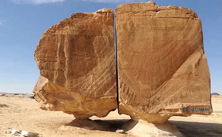
A massive 4,000-year-old monolith split with laser-like precision
Al Naslaa may look like nothing more than a massive rock to some, yet it is one of the most fascinating geological formations in history. The captivating formation is located far inside the Tayma Oasis in Saudi Arabia, where it has puzzled and entranced historians, geologists, and tourists for years. The formation features a huge piece of sandstone (with unique shaping on both sides) balanced on a naturally-formed pedestal. What makes the formation so unique? It’s split!
What makes the Al Naslaa formation famous
Al Naslaa is unique not only because of its shape, location, and age but also due to the precise break that separates one half of the formation from the other. While it may look like a simple crack in the foundation of the sandstone, the break is so exact and straight that it looks as if though someone took a laser to the rock to split it apart. In addition, the two remarkably heavy sides of the formation seem to balance on nothing more than thin pieces of rock, appearing to nearly gravitate in thin air.
In order to assess the nature of how the famed formation came to be, it’s important to recognize its history. The formation has existed since ancient times and has taken centuries to acquire its shape. Al Naslaa is only one of many rocks in the Tayma Oasis that features a unique appearance, as the limestone, shale, and sandstone there have spent centuries culturing into fantastic formations (with the help of a little rain and wind, of course).
Before these formations even developed into the stunning shapes they occupy today, the Tayma Oasis was occupied by everyone from Babylonian royalty to everyday traders on their route. They interacted with the landscapes in various ways, including writing and drawing on the rocks. In addition to its famed formation, Al Naslaa is fortunate enough to feature one of these petroglyphs on its surface: the figure of a horse.
Thanks to the ancient people who interacted with Al Naslaa (in addition to its geological history), we can tell that Al Naslaa has been a primary part of the Tayma Oasis for as long as the landscape has existed. But what does its shape—along with its iconic split—tell us about how the rock formation came into existence?
The scientific theories behind the formation
Across the years, historians have tried to understand the features that set Al Naslaa apart from the thousands of similar sandstone formations in the Saudi Arabian oasis. In addition to its split, one thing that is unique about Al Naslaa is the smoothness of the front of the rock, despite the round/jagged shaping on either side.
If you were to look at the rock from the side rather than the front, the smoothed-out surface concealing the famous crack might make it look as if though someone sanded the front-facing portion of the formation down. And technically, the elements have.
“The standing stones of Al Naslaa truly are a big mystery. Two stones split in half have created confusion among experts ever since their discovery.”
– Charismatic Planet, YouTube
Considering the nature of sandstone, the flat shaping on the front is unsurprising, as wind and rain have beaten away at the smooth sections of rock. However, natural elements can not explain the thin crack separating either side of the massive rock, or how they have managed to stay perfectly balanced on either of their thin platforms. What have scientists theorized about how the great divide came to be?
The likely cause of the split
According to geologists, the likely cause for the split is tectonic motion. The most likely natural cause of the formation is that the ground shifted ever-so-slightly beneath the supporting beam of one half of the rock, and it caused the rock to split into two. This is the most widely supported theory in the scientific world, though others have speculated at other natural (and unnatural) causes for the rock’s separation.
Other scientists theorize that the split is, in fact, a fault line, as the material surrounding faults tends to be weaker and erode more easily at the will of the elements. If this is the case, then the wind is likely what tore away at the weak material of the fault, leaving behind the near-solid remaining halves of the rock.
In addition, there is potential that the split is the result of a joint (fractures formed at weak points in rock formations) that may have been formed by a type of erosion, such as wind, water or ice.
“This rock formation is called Al Naslaa. The uniform slit between the two standing stones and the flat faces are completely natural. Most likely the ground shifted slightly underneath one of the two supports and the rock split. Could be from a volcanic dike of some weaker mineral that solidified there before everything was exhumed.”
– Hashem Al-Ghaili
However, there are still more theorists who believe that the formation is not a natural occurrence at all. Although scientific evidence backs up the idea that Al Naslaa was not man-made, the conflicting opinions of its formation—in addition to its perfect split—have caused some to turn to other sources of explanation…including the supernatural.
The rumours behind the ancient rock
In addition to the potential natural causes of Al Naslaa, many people—from scientists to conspiracy theorists—have other ideas about how the rock gained its unusual shape. One such theory? Aliens. Considering the formation looks as if though it was cut apart by a well-aimed laser, some believe that a U.F.O. descended into the Tayma Oasis and zapped the rock apart with advanced technology not available to humans at its formation.
While this is a more bizarre theory, plenty of people have put their chips into it, believing that the break between the two halves of the rock is too perfect to have been produced by erosion. In addition, there are others who feel that there is a potential that the ancient settlers of the civilization that first came into contact with Al Naslaa were the ones who managed to split the rock apart. Still, their theories about how they pulled this off might be even tougher to believe than the theory about aliens.
Those who feel that ancient civilizations pulled the rock apart don’t believe they did it by sheer man-power, a giant wire, or by tying either end of the rock to a camel carriage. Rather, they feel that there is the potential that advanced humans lived in the Tayma Oasis who were able to successfully craft, aim, and fire a laser to split the rock apart. Considering the precise nature of the crack, it’s understandable why people might feel that there is no way that nature is responsible for the break.
If the Flinstones met the Jetsons, the laser-theory may have been possible, yet most geologists and historians are highly doubtful that this possibility is well-founded. There is no charted technology of that caliber in ancient civilizations. However, with no one there to view the rock’s formation and discredit the more outlandish theories, the chance that the formation was created by superhumans, aliens, or robots remains up for debate.
The current life of Al Naslaa
Today, Al Naslaa is not only a marvel in the scientific community, but is beloved by those who come to visit the formation. People travel from around the world to witness the fascinating and mysterious bit of landscape. Fortunately, the historical rock is open for all to see, touch, and photograph. Reaching the landmark by car on the dirt road is the best route, though some choose to park further back and walk partially through the desert-land to explore other elements of the landscape.
“Sometimes you’ve just got to take a moment out of your day to gaze at an inexplicable petroglyph located in Tayma – about an eight-hour drive out of Riyadh, Saudi Arabia. Take a little time to take in two rocks poised on insubstantial plinths, separated by a thin, perfectly vertical gap.
Appreciate the empty divide. Perfect, as if the rock were geologic Gruyère de Comté to which the [A]lmighty took a wire cheese slicer.”
– smith journal
Al Naslaa is not only relevant in historical and scientific circles, but remains a love of many tourists, photographers, and conspiracy theorists worldwide. The photogenic rock that seems to defy all logic continues to mystify those in academic/scientific circles and those beyond it, all of whom are fascinated by the shape, structure, and appearance of the iconic stone.
While we may never know the true root of the formation’s centuries-long shaping—and the rock is still being shaped in real-time by erosion—the debate doesn’t influence the fact that the fascination and intrigue surrounding the formation will never die down.
Leshan Giant Buddha -largest carved stone Buddha in the world
The Leshan Giant Buddha is a huge statue carved into the side of Lingyun Mountain. Taller by 17 meters than the standing Buddha in Afghanistan, the Leshan Giant Buddha is the tallest and largest Buddha in the world.
Leshan Giant Buddha
There is a local saying: “The mountain is a Buddha and the Buddha is a mountain”. It was included by UNESCO on the list of World Heritage sites.
The Size of the Giant Buddha
The head is 14.7 meters long and 10 meters wide.
The head is 14.7 meters long and 10 meters wide.
The statue depicts a seated Maitreya Buddha with his hands resting on his knees and a smile on his face. The Leshan Giant Buddha is about 71 meters high and 24 meters wide. The head is 14.7 meters long and 10 meters wide with 1,021 buns of hair on it.
His smallest toenail can accommodate a seated person. Each ear is 7 meters long and his nose is 5.6 meters long. Each eyebrow is 5.5 meters long.
The instep, which is 8.5 meters wide, can accommodate 100 people. The toe is large enough to accommodate a dining table.
Giant Sleeping Buddha
Behind the Leshan Giant Buddha, a sleeping Buddha with a body length of more than 4,000 meters “floats” peacefully on the water.
The head, body, and foot of the Buddha are composed of Wuyou Mountain, Lingyun Mountain, and Guicheng Mountain. The best way to observe the sleeping Buddha is taking a trip on a sightseeing boat.
Nine Bends Plank Road
It is a steep plank road with nine turns on the right side of the Leshan Giant Buddha. You can walk along the road from the Buddha’s head to its foot.
The widest part of the road is 1.45 meters and the narrowest part is only 0.6 meter, and there are 217 stone steps in total.
Oriental Buddha Park
It is a Buddhist theme park integrating sculptures, religion, and garden art. The park contains more than 3,000 Buddhist statues, including a 170-meter-long reclining Buddha, which is the largest in the world.
Lingyun Temple
Located next to the Leshan Giant Buddha, Lingyun Temple has a history of over 1,400 years.
Lingyun Temple
It is a quadrangle courtyard composed of the Tianwang Hall, the Daxiong Hall, and Depository of Buddhist Sutras. You can get to the Buddha’s head by crossing through Lingyun Temple.
Construction History
In ancient times, Leshan was at the confluence of the Min River, the Qingyi River, and the Dadu River. The tempestuous waters caused numerous boat accidents and caused people to suffer who earned their living around the area.
A monk called Hai Tong thought that the spirit of the Buddha could suppress the tempestuous waters so he initiated its construction. The project was half done when Hai Tong passed away and two of his disciples continued the work. After a total of 90 years’ hard work, the project was finally completed.
Special Drainage System
The Leshan Giant Buddha has a special drainage system so that it can be well-preserved. Several drainage passages are hidden in the Buddha’s hair, collar, chest, and holes in the back of his ears and chest, preventing the statue from serious erosion and weathering.
The Buddha has been lovingly maintained on a regular basis throughout his 1,200-year history. Moss, however, does grow on the statue.