Category Archives: ENGLAND

387-Year-Old Shopping List Discovered Under Floorboards In Historic English Home

387-Year-Old Shopping List Discovered Under Floorboards In Historic English Home

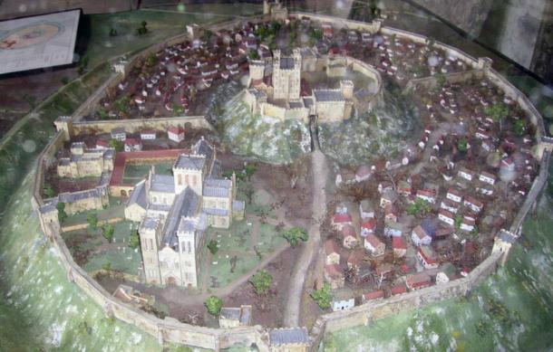
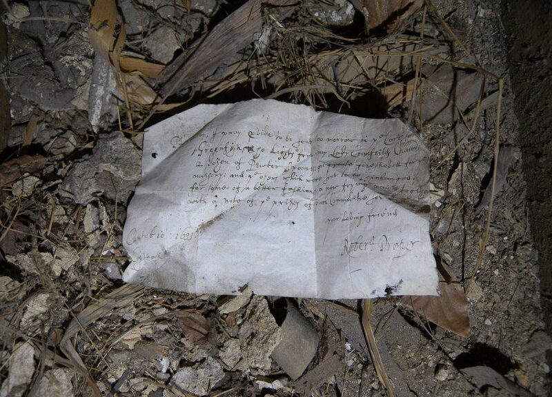
Such must-have items were listed on a shopping list 387 years back, including pewter spoons, frying cups and “greenfish.” Under the floors of Knole, a historic country house in Kent, England, a scrap of paper has recently been discovered.

Among other necessary items, the list includes “greenfish,” a “fireshovel” and two dozen pewter spoons.

Jim Parker, an archeology volunteer at Knole, has found the 1633 note for the restoration of the building, as reported for Kent Live by Oliver Porritt.

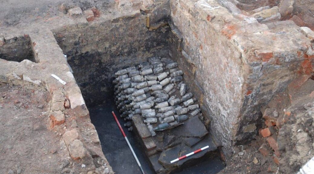
The team also found two other 17th century letters nearby. One, like the shopping list, was located under the attic floorboards; another was stuffed into a ceiling void.

The shopping list was penned by Robert Draper and addressed to one Mr. Bilby.

According to the UK’s  National Trust, the note was “beautifully written,” suggesting that Draper was a high-ranking servant.

In addition to the aforementioned kitchenware and greenfish (unsalted cod), Draper asks Mr. Bilby to send a “fire shovel” and “lights” to Copt Hall (also known as Copped Hall), an estate in Essex. The full text reads:

Mr. Bilby, I pray p[ro]vide to be sent too morrow in ye Cart some Greenfish, The Lights from my Lady Cranfeild[es] Cham[ber] 2 dozen of Pewter spoon[es]: one greate fireshovell for ye nursery; and ye o[t]hers which were sent to be exchanged for some of a better fashion, a new frying pan together with a note of ye prises of such Commoditie for ye rest.

Your loving friend

Robert Draper

Octobre 1633

Copthall

Jim Parker, a volunteer working with the archaeology team at Knole, discovered the 1633 note during a multi-million dollar project to restore the house.

How did this rather mundane domestic letter come to be stashed in an attic at Knole, which is some 36 miles away from Copt Hall?  As the National Trust explains, Copt Hall and Knole merged when Frances Cranfield married Richard Sackville in 1637.

Cranfield was the daughter of the Earl of Middlesex, who owned Copt Hall; Sackville, the 5th Earl of Dorset, had inherited Knole, his family’s home.

Household records indicate that large trunks filled with domestic items—including various papers—were moved from Copt Hall to Knole at the time of the marriage, and subsequently stored in the attic. Draper’s note may have slipped under the floorboards.

The marriage of Cranfield and Sackville was important for Knole, according to the National Trust Collections, because Cranfield inherited a trove of expensive paintings and furniture from her father.

Draper’s letter certainly was not among the more prized items that Cranfield brought to the marriage, but for modern-day historians, it is exceptionally valuable.

“It’s extremely rare to uncover letters dating back to the 17th century, let alone those that give us an insight into the management of the households of the wealthy, and the movement of items from one place to another,” Nathalie Cohen, regional archaeologist for the National Trust, tells Porritt.

She added that the good condition of both the list and the two other letters found at Knole “makes this a particularly exciting discovery.”

Archaeologists Reveal the Hidden Horrors of Only Nazi SS Camp on British Soil

Archaeologists Reveal the Hidden Horrors of Only Nazi SS Camp on British Soil

One of the British Channel Islands has a German concentration camp which has been a location for terrible atrocities, which have been downplayed in official reports after the end of World War II. Now, a new investigation reveals details that were kept hidden from the public for decades. 

Photograph of the Sylt concentration camp taken in 1945.

The only German concentration camps on British soil existed during WWII on the island of Alderney — part of an archipelago in channel waters between France and the United Kingdom

There, inmates endured brutal treatment, including hard labor, beatings, and starvation; but the full extent of what they suffered was not widely known even after the war ended. 

Recently, archaeologists pieced together the story of Alderney’s Sylt camp by examining declassified satellite images and exploring ruined buildings at the site.

They created the first map of the camp, which was built by the Nazis in 1942 and used first as a forced labor camp for political prisoners and then as a concentration camp, researchers reported.

The northernmost of the British Channel Islands, Alderney measures about 3 miles (5 kilometers) long and1.5 miles (2.4 km) wide. Sylt was originally constructed there to house 100 to 200 prisoners, about 20% of which died of poor treatment during the first year, according to a study published online on (March 30) in the journal Antiquity. 

Approximately 1,000 more people were transferred to the camp in 1943 — far more than Sylt was built to accommodate. 

Around that time, prisoner supervision was handed over to a Nazi paramilitary group called “Totenkopfverband” (Death’s Head Unit). Testimonies from Sylt survivors described 12-hour days of heavy construction work and little food, and guards who would beat the prisoners “with everything they could lay their hands on,” according to the study. 

But as Germany’s hold on Europe weakened, the Nazis began systematically destroying their own records regarding Sylt and other concentration camps, to hide the evidence of their crimes.

Sylt closed in 1944, and after the war’s end, British authorities on Alderney and the mainland conducted approximately 3,000 interviews with camp survivors, witnesses, and German officers. Their official report wasn’t released publicly until 1981, and it softened the worst of the details to quell rumors about the “death camp” in the British Channel, the scientists wrote in the study.

Aerial view of the site of the former labor and concentration camp of Sylt, and the memorial plaque installed on the camp gateposts in 2008, by a survivor.

Experts returned to Sylt in 2010 to evaluate the site and create the first reconstructions of the camp using archaeological methods, to better understand the inmates’ living and work conditions.

They visited the island, clearing vegetation and examining the camp’s few remaining structures; they also used a remote-sensing method known as light detection and ranging, or lidar, to survey the former camp from above and map differences in elevation that would indicate where buildings once stood and how they were constructed.

Their maps and 3D digital models showed that the prisoners’ barracks were poorly built and unable to keep out the wind and cold. The buildings would also have provided only about 5 feet (1.5 meters) of living space per person, resulting in severe overcrowding.

These findings corroborate witness testimony about outbreaks of lice and typhus, which would have spread quickly among people who were living in uncomfortably close quarters under unhygienic conditions, the authors said.

By comparison, according to the research, the Nazi guards lived comfortably, in buildings made of reinforced concrete surrounded by stone walls “to protect them from the weather and air raids,” the study authors wrote. 

Images from Sylt: A) The toilet block; B) prisoner kitchen cellar; C) stable block; D) the SS orderly room.

According to Nazi records, only 103 people died at Sylt of “faulty circulation” or “heart failure,” according to preprinted death certificates that the camp provided to Alderney doctors. But the recent discovery of mass graves on the island suggests that at least 700 people perished at Sylt; these new findings will help to ensure that their stories won’t be forgotten, the study authors wrote.

“This work has shed new light on the German occupation of Alderney and, crucially, the experiences of the thousands of forced and slave laborers who were sent there,” said lead study author Caroline Sturdy Colls, a professor of conflict archaeology and genocide investigation at Staffordshire University in the United Kingdom. 

“Historical, forensic and archaeological approaches have finally offered the possibility to uncover new evidence and give a voice to those who suffered and died on Alderney so many years ago,” Colls said in a statement. 

Rare Roman Cavalry Swords And Toys Unearthed Along Hadrian’s Wall

Rare Roman Cavalry Swords And Toys Unearthed Along Hadrian’s Wall

Swords, arrowheads and ballista bolts amongst a cache of artifacts discovered during cavalry barrack excavations at Roman Vindolanda. Archaeologists at the Roman fort of Vindolanda have made one remarkable discovery after another in what has been an exceptional year for the research excavations.

Aerial view of remains of 4th century stone fort at Vindolanda

Test pit excavations, below the stone foundations of the last stone fortress, revealed a layer of black, sweet-smelling and perfectly preserved anaerobic, oxygen-free, soils in an area where they were completely unexpected.

Hidden in this soil were the timber walls and floors, fences, pottery and animal bones, from the abandonment of a Roman cavalry barrack. The excavated rooms included stables for horses, living accommodation, ovens and fireplaces.

While excavating the material from the corner of one of the living rooms a volunteer excavator made an outstanding discovery.

The earth surrounding the object was slowly pulled back under careful supervision to reveal the tip of a thin and sharp iron blade, resting in its wooden scabbard.

As the archaeologists excavated further the shape of a hilt and handle slowly emerged from the black soil and it became immediately clear that the Romans had left behind a complete sword with a bent tip. It was the ancient equivalent of a modern soldier abandoning a malfunctioning rifle.

Dr Andrew Birley recalled the moment as “quite emotional” and went on to say, “you can work as an archaeologist your entire life on Roman military sites and, even at Vindolanda, we never expect or imagine to see such a rare and special object as this.

It felt like the team had won a form of an archaeological lottery.” Rupert Bainbridge, the volunteer who made the initial discovery described the moment as overwhelming, commenting, “I was so excited to excavate such an extraordinary artefact, especially something that resonated so much with the fort setting that we were digging in.”

A few weeks later, Vindolanda archaeologists accompanied by a new team of volunteers were finishing working on a room adjacent to the one in which the sword was discovered.

Here they remarkably discovered a second sword, this time without a wooden handle, pommel or scabbard, but with the blade and tang still complete and sitting on the floor exactly where it had been left thousands of years before.

Cavalry sword unearthed at Vindolanda

Dr. Birley commented, “You don’t expect to have this kind of experience twice in one month so this was both a delightful moment and a historical puzzle. You can imagine the circumstances where you could conceive leaving one sword behind rare as it is…. but two?” Both blades came from separate rooms, and are likely to have belonged to different people. One theory is that the garrison was forced to leave in a hurry, and in their haste, they left not only the swords but also a great number of other perfectly serviceable items that would have had great value in their time.

The swords are truly remarkable, but they form only part of an outstanding collection of artefacts left behind in those cavalry barrack buildings. In another room were two small wooden toy swords, almost exactly the same as those that can be purchased by tourists visiting the Roman Wall today.

Roman ink writing tablets on wood, bath clogs, leather shoes (from men, women, and children), stylus pens, knives, combs, hairpins, brooches and a wide assortment of other weapons including cavalry lances, arrowheads, and ballista bolts were all abandoned on the barrack room floors.

Copper alloy cavalry strap junction

Quite spectacular are the copper-alloy cavalry and horse fitments for saddles, junction straps and harnesses which were also left behind. These remain in such fine condition that they still shine like gold and are almost completely free from corrosion.

The swords and other objects form a remarkable discovery of one of the most comprehensive and important collections of this type of material from a Hadrian’s Wall site.

Visitors to Vindolanda will be able to see this cache of cavalry finds displayed in the site museum this autumn, just as a major Hadrian’s Cavalry exhibition along the line of Hadrian’s Wall comes to a close another has arrived!

Dr Andrew Birley with sword

Historical facts

The Garrison at Vindolanda at this time (cAD120) was made up of a combination of peoples including the 1st Cohort of Tungrians who heralded from modern day Belgium.

They were joined by a detachment of Vardulli Cavalrymen from northern Spain. It is likely that the base held more than 1000 soldiers and probably many thousands more dependants including slaves and freedmen, representing one of the most multicultural and dynamic communities on the Frontier of the Roman Empire at the time.

The new finds give an intimate insight into the lives of people living on the edge of the Roman Empire at a time of rebellion and war before the construction of Hadrian’s Wall in AD122.

Lost Medieval Chapel Unearthed 370 Years After Destruction

Lost Medieval Chapel Unearthed 370 Years After Destruction

The ruins of an old medieval chapel, comparable to some of the greatest in Europe, have been uncovered at Auckland Castle in County Durham, North East England.

Historical documents show that a two-storey chapel, described as ‘sumptuously constructed’ and ‘exceedingly good,’ was built at Auckland Castle, Bishop Auckland in the early 1300s.

It was created for Bishop Antony Bek, (Prince Bishop of Durham 1284-1310), a great warrior and one of the most powerful and influential men in Europe at the time.

Despite it being larger than the king’s own chapel at Westminster, and with pieces of carved stone weighing the same as a small car, the exact location of the 14th-century chapel has remained a mystery since its destruction in the 1650s, following the English Civil War.

Now, following years of archaeological excavations, Bek’s Chapel has finally been discovered and the full extent of its spectacular scale will be revealed to the public in a special exhibition at Auckland Castle.

A new reconstruction image of the medieval building will be on display in the exhibition, alongside finds uncovered by archaeologists from Durham University and The Auckland Project, the charity that owns and manages Auckland Castle.

Archaeologists excavating the Bek’s Chapel site at Auckland Castle.

The foundations of Bek’s Chapel were found during digs over a five-month period, which revealed that the walls of the medieval chapel were 1.5m thick, 12m wide and 40m long internally.

Archaeologists also found huge bases for internal columns, the buttresses along the chapel’s sides and even part of the floor. And over 300 pieces of elaborately carved stone were excavated, from fragments the size of a fist up to those the weight of a small car.

Stained glass from the long-lost Bek’s Chapel. This fragment shows a pelican pecking her own breast – a traditional Christian symbol representing Christ’s self-sacrifice.

The uncovered evidence suggests that the original chapel was a vast structure, reaching towards the size of continental chapels such as Sainte-Chapelle in Paris and featuring a timber ceiling and huge pillars with decorated stonework.

Archaeologists believe the chapel’s size, scale and decoration would have been a statement of the status of Bishop Bek, who as Prince Bishop of Durham held remarkable powers to mint coinage, raise armies and even rule on behalf of the king.

In the months following the discovery of the chapel, archaeologists from The Auckland Project and Durham University have been working with a panel of archaeological experts, including Architectural Historians Tim Tatton-Brown, Tim Ayers and John Crook, to create a reconstruction of Bek’s Chapel, as it would have looked in the 14th century.

The team mapped details from elements of comparable buildings, including kings’ chapels, cathedrals, and minsters, to suggest the kind of glasswork, carved stone and roof construction that would have featured in Bishop Bek’s original chapel.

Stuart Harrison, Archaeologist at York Minster, recorded the geometry of the discovered foundations and stonework to reconstruct the framework of the original building.

And illustrator, Andy Gammon combined the information with his own research to bring the Chapel to life through a colored reconstruction, with a cut-away opening up the chapel’s interior as well as an aerial view from the South West.

Reconstruction of Bek’s Chapel in Auckland Castle

The team of archaeologists from The Auckland Project and Durham University will return to Auckland Castle this summer to continue their excavation of Bishop Bek’s Chapel where they are hoping to uncover more of the south side of the building.

And, some of the uncovered carved stonework will be on display for visitors to examine in an upcoming exhibition Inside Story: Conserving Auckland Castle at the Bishop Trevor Gallery at Auckland Castle.

Oldest Preserved Spider Web dates back to Dinosaurs

Oldest Preserved Spider Web dates back to Dinosaurs

The oldest known spider web in the world has been discovered on a beach in the English city of Sussex, caught inside an ancient amber chunk

 Baltic amber.

In December scientists found the rare amber fossil and have now confirmed that it contains remains of spider silk woven by an ancestor of modern spider weaving spiders some 140 million years ago.

The researchers discovered that ancient silk threads share many common features in modern spider webs, including droplets of sticky glue that are used for holding the web together and catching the prey after cutting the amber into thin sections and examining every piece under the powered microscope.

According to paleobiologist Martin Brasier of Oxford University, the gooey droplets suggest that spiders were starting to spin webs that were better adapted for catching flying insects.

“Interestingly, huge radiation took place in flying insects and bark beetles about 140-130 million years ago,” Brasier wrote in an email to Wired.com. “So we may be seeing a co-evolution of spiders and insects here.”

The new discovery is the first example of an amber fossil from the early Cretaceous period when dinosaurs like spinosaurus and psittocosaurs roamed the Earth.

“Silk is a relatively delicate material and it is rarely preserved in the fossil record, except when entombed in amber,” Brasier and colleagues wrote about the discovery in the upcoming December issue of the Journal of the Geological Society. 

The researchers think pieces of organic material, including the spider silk, became embalmed during a severe wildfire when amber resins seeped out from the charred bark of coniferous trees and were eventually swept away by flooding.

In addition to ancient spider silk, the amber chunk contains well-preserved soil microbes, including the oldest known examples of actinobacteria, a common type of bacteria that plays a major role in soil formation.

19th-century beer bottles found under the staircase in England

19th-century beer bottles found under the staircase in England

WYAS Archeological Services made the finding back in February and subsequently sent out the bottles for analysis.

The team discovered a set of cellar stairs in the ruins of what was the Scarborough Castle Inn after investigating an area within the site of the former Tetley’s Brewery.

Neatly piled on the stairs was a collection of over 600 bottles, initially thought to contain ginger beer.

But it was discovered that the bottles were filled with alcohol and, even more, high concentrations of lead after the samples were sent for review by West Yorkshire Joint Services.

In a social media post, archaeological services WYAS said that the bottles contained 5.07 pH beer with 3% ABV alcohol. However, the liquid contained 0.13mg/l of lead, far above the WHO-recommended safe level in water of around 0.01mg/l.

Researchers analyzed hundreds of old beer bottles discovered in the United Kingdom.

The team said they suspect the high metal content would have come from lead pipes, and that the beer “would have been detrimental to health”.

The bottles themselves hail from a number of different breweries, with the most from ‘J. E. Richardson of Leeds’. The archaeologists hope to complete their work in the area in the next two weeks, after which they will compile a report of their findings.

Speaking to the drinks business, senior project manager at Archaeological Services WYAS, David Williams, said that the team thought the bottles dated to the later 19th century, “perhaps the 1880s”.

He added that the developer, Vastint, intends to keep the bottles and make a feature of them within the new development of the former Tetley’s Brewery.

“This excavation is giving us a great opportunity to uncover a part of Georgian and Victorian Leeds. The results so far are giving a real insight into the daily lives of the former residents of Leeds during this period,” he said.

Tests Underway to Solve Enigma of Naked Cerne Abbas Giant

Tests Underway to Solve Enigma of Naked Cerne Abbas Giant

For the first time, archaeologists attempt to establish the age of the mysterious Cerne Abbas Giant.   The Cerne Abbas Giant is a 55 m nude chalk figure brandishing a giant club overlooking Cerne Abbas village in Dorset, England.

The origins and purpose of Britain’s largest chalk hill figure remain shrouded in mystery.  The giant chalk figure was gifted to the National Trust in 1920 by the Pitt-Rivers family.

The charity and Gloucestershire University also conduct research to determine the age of the giant.   Archeologists have excavated small trenches to enable samples of soil to be extracted from points on the giant’s elbows and feet.

An aerial view of the Cerne Abbas Giant, a hill figure near the village of Cerne Abbas in Dorset
A closer aerial view showing the hillside on which the giant is carved into which was gifted to the National Trust in 1920 by the Pitt-Rivers family. The charity is now researching the giant

Professor Phillip Toms from Gloucestershire University will attempt in the coming weeks to date the samples using a technique called optically stimulated luminescence (OSL).

Martin Papworth, a senior archaeologist at the National Trust, said: ‘The OSL technique is commonly used to determine when mineral grains in the soil were last exposed to sunlight.

‘It was used to discover the age of the Uffington White Horse in Oxfordshire in the 1990s, which was found to be nearly 3,000-years-old – even more ancient than we had expected.

‘We’re expecting the results of the tests in July. It is likely that the tests will give us a date range, rather than a specific age, but we hope they will help us better understand, and care for, this famous landmark.’

Volunteers from the National Trust cleaning and restoring the giant for the first time in 2019
Volunteers working to repair and refresh the Cerne Abbas Giant in Dorset. Archaeologists are attempting to determine for the first time the age of the mysterious Cerne Abbas Giant

Gordon Bishop, chairman of the Cerne Historical Society, said villagers were eagerly awaiting the results.

‘Although there are some who would prefer the giant’s age and origins to remain a mystery, I think the majority would like to know at least whether he is ancient or no more than a few hundred-years-old,’ he said.

‘Whichever may be the case, he is unique.’

In a separate analysis, environmental archaeologist Mike Allen will analyze soil samples containing the microscopic shells of land snails to learn more about the site’s past.

‘There are 118 species of snails in Britain and many of them are habitat-specific, so their preserved shells can help us establish what a landscape was like at a certain time, and to track changes in land use over time,’ he said.

‘They should help us to discover whether the giant was created on a grazed chalk hillside, or whether people purposely cleared scrub to prepare the land for the figure.’

Last year, the giant was refreshed for the first time in 11 years, with a team of volunteers hammering in 17 tonnes of new chalk by hand to counteract weathering and keep the giant visible for miles around. 

Theories as to the purpose of the giant are unclear. Everything from it being an ancient spirituality symbol or likeness of Greco-Roman hero Hercules to a caricature of Oliver Cromwell, with the club a reference to repressive rule and the phallus a mockery of his puritanism, have been put forward as suggestions. 

Local folklore has long held it to be a fertility aid and the earliest recorded mention of the giant dates from 1694.

Archaeologists find vast medieval palace buried under prehistoric fortress at Old Sarum

Archaeologists find vast medieval palace buried under prehistoric fortress at Old Sarum

Old Sarum archeological site in Wiltshire, England has a rich history covering at least 5,000 years. Nevertheless, the site selection of William the Conqueror for his royal castle in the 11th century left the mark on this historic landmark.

An aerial photograph of the site of Old Sarum. The newly discovered probable royal palace is under the grass in the quadrant opposite the foundations of the cathedral. The massive earthworks surrounding the site are from the Iron Age. The earthwork in the center is the medieval castle mound (English Heritage)

Geophysical surveys suggest that what lies beneath the surface can be one of the biggest royal medieval palaces ever discovered, built within the grounds of a vast Iron Age fortress, and hidden beneath fields for more than 700 years.

According to a report in The Independent, the high-tech scans carried out by archaeologists from the University of Southampton, including magnetometry, earth resistance, ground-penetrating radar, and electric resistivity tomography survey, have revealed the foundations of dozens of houses and an enormous, previously unknown complex, measuring 170 ms (558 ft) long and 65 m (214 ft) wide, which is believed to have been a royal palace.

“The prime candidate for constructing it is perhaps Henry I sometime in the early 12th century,” said one of Britain’s leading experts on high-status medieval buildings, Dr. Edward Impey, Director-General of the Royal Armouries.

The complex was arranged around a large courtyard with 3 m (10 ft) wide walls and included a long building, which was probably a grand hall. There is also evidence of towers and multi-storey buildings. If it is indeed a medieval royal palace, it is the largest of its kind ever found in Britain. Up until now, archaeologists were only aware of the much smaller complex on top of the man-made castle mound.

A geophysical ‘x-ray’ image showing the structures which have lain buried in the ground of Old Sarum for more than 700 years

Old Sarum was originally an Iron Age hill fort, built-in 400 BC on a site that had been inhabited since at least 3,000 BC. The site was used by the Romans, becoming the town of Sorviodunum. The Saxons also used the site as a stronghold against marauding Vikings.

In the 11 th century, William the Conqueror, having gained control of England, chose Sarum as the location for a royal castle. The fact that it lay inside a large hill fort meant that defenses could be constructed very quickly.

The castle was built on a motte (raised earthworks) protected by a deep dry moat in 1069, three years after the Norman conquest.

The construction of a cathedral and bishop’s palace occurred between 1075 and 1092. A royal palace was then built within the castle for King Henry I and subsequently used by Plantagenet monarchs.

Reconstruction of Old Sarum in 12 th Century. The model includes the previously known castle of William the Conqueror in the center, and the cathedral, but does not show the newly discovered palace.

By 1219, the limitations of space on the hilltop site had become a cause for concern, with the cathedral and castle in close proximity and their respective chiefs in regular conflict.

The abandonment of Old Sarum by the clergy during the 1220s marked the end of serious royal interest in the castle. The castle continued in use but was largely abandoned by the 16th century.

The new research has enabled archaeologists to piece together the layout of the old Medieval city, shedding new light on the urban planning of a Norman city.

“This is a discovery of immense importance,” said historian, Professor David Bates of the University of East Anglia. “It reveals the monumental scale of building work taking place in the earlier 12th century.”

While the significance of Old Sarum has been known about for some time, only now are archaeologists beginning to piece together the long-vanished city buried beneath the green fields that thousands of tourists visit every year.