2,000-year-old Roman street unearthed in Turkey’s Diyarbakır
A 2,000-year-old street from the Roman period has been discovered in southeastern Turkey. The historic city of Diyarbakır, situated in southeastern Turkey, is home to innumerable ancient wonders and relics from throughout history.
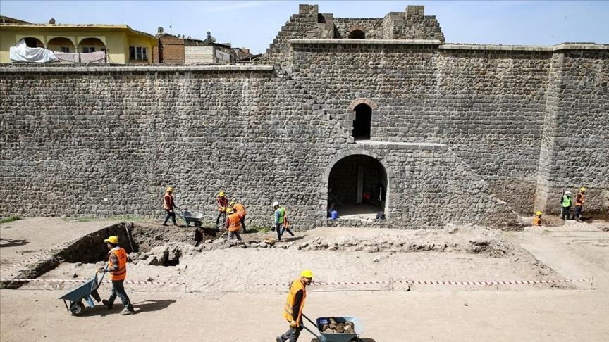
Archaeological workers continue efforts to unearth a Roman-era street at the ancient Amida Höyük site in Diyarbakır, Turkey.
Currently, excavation to unearth the historical Roman street is being carried out in Amida Höyük, a mound known as the heart of Diyarbakır province while also being the historical Roman name of the city, along with Amed which was what it was called in the Assyrian period and modern-day Kurdish.
Professor Irfan Yıldız from Dicle University is leading the excavation amid strict measures against the coronavirus pandemic.
“Very interesting data continues to come from the west side of the mound we excavated. The street texture and structure of the period has started to emerge,” Yıldız said.
Yıldız noted that over the period of a year they expect to unearth many historical artefacts in the excavation.
Yildiz said by 2022 tourists using the Roman street will be able to visit the historical region of Içkale and be able to see streets from the Roman, Ottoman and Republican periods.
Diyarbakır was historically situated around a high plateau by the banks of the Tigris river on which stands the historic Diyarbakır Fortress.
Tigris was one half of the word “Mesopotamia” which translates to “between the rivers” in ancient Greek, a reference to the Tigris and Euphrates rivers that helped humanity thrive but also plunged it into some of the bloodiest wars of history.
Many small and large-scale states and empires were built upon the soil which offered plentiful natural resources essential for survival.
The city was conquered by Muslims in 639, only a few years following the conquest of Mecca in Saudi Arabia, which stands as the holiest city of Islam.
Today, Diyarbakır is home to the Hevsel Gardens which have been used for agricultural purposes for more than 8,000 years, the Great (Ulu) Mosque, one of the oldest mosques of Anatolia and the Malabadi bridge built during the Artuqid period in the 12th century.
Meanwhile, it is also home to the Hasuni Cave city where pre-historic people lived during the early years of Christianity, and the Zerzevan Castle, which is a Roman military facility containing the temple of Mithraism, a mysterious religion.
17th-Century Mourning Ring Unearthed on the Isle of Man
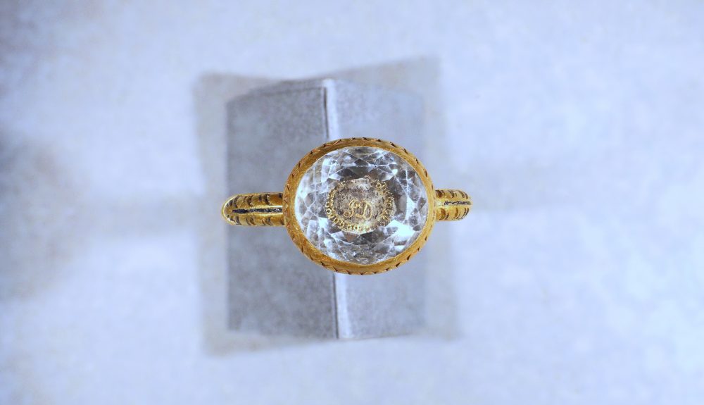
Manx Radio reports that a metal detectorist on the Isle of Man uncovered a piece of jewellery identified as a Stuart-period mourning ring made of crystal and gold inlaid with black enamel at the time of the English Civil Wars (1642–51) and will soon go on view at a local museum.
The accessory, which is inscribed with the initials “JD”—or possibly “ID”—is a mourning ring of the type given out at funerals during the Stuart period (1603–1714). Its sloping sides are adorned with engravings of leaves inlaid with black enamel.
“The ring is small and quite delicate in form, but of a high quality and intact,” says Allison Fox, an archaeologist at Manx National Heritage, in a statement. “The quality suggests that it was made for, or on behalf of, an individual of high status.”
James Stanley supported the Stuart monarchy during the English Civil Wars, which pitted Royalists against Oliver Cromwell’s Parliamentarians.
Though Fox points out that researchers may never be able to definitively determine the ring’s origins, she says that it could have been connected with the Stanley family, which ruled as the Lords of Man for more than 300 years.
“The initials JD may refer to James Stanley, 7th Earl of Derby and Lord of Man, a supporter of the Royalist cause in the Civil War,” adds Fox in the statement. “Letters and documents from the time show that he signed his name as J Derby, so the initials JD would be appropriate for him.”
As the Isle of Man’s legislature, Tynwald, notes on its website, Henry IV granted the island to Sir John Stanley I in 1405.
In exchange for their continued possession of the island, the crown demanded that the Stanleys remain loyal and send two falcons to all future kings of England upon their coronations. John’s grandson Thomas—stepfather to Henry VII, the kingdom’s first Tudor monarch—received the title of Earl of Derby in 1485, and the family continued to rule under that title for centuries.
After James Stanley, 7th Earl of Derby was executed in 1651, his wife, Charlotte, worked to preserve his memory.
James Stanley, who was also known as Baron Strange for part of his life, became a Royalist commander in service of Charles I, and later Charles II, during the English Civil Wars, which pitted supporters of the monarchy against Oliver Cromwell’s Parliamentarian forces.
In 1651, Cromwell’s men captured and executed James. His eldest son, Charles, succeeded him. After James’ death, reports BBC News, his wife, Charlotte, worked to ensure that he was not forgotten.
Metal detectorist Lee Morgan discovered the ring while exploring the south side of the island, which is a British dependency located off the northwest coast of England, last December.
The exact location is being kept secret to protect the site. (That same month, noted BBC News in February, a retired police officer on the Isle of Man unearthed a cache of 1,000-year-old Viking jewellery.)
Morgan, for his part, has previously unearthed two other treasure troves: In 2013, he found a horde of silver coins from the 1300s, and in 2019, he discovered a silver ingot dated to between 950 and 1075, during the island’s Viking period.
The Isle of Man’s coroner of inquests, Jayne Hughes, has declared the Stuart ring treasure under the United Kingdom’s Treasure Act. (Current guidelines define treasure very narrowly, but as Caroline Davies wrote for the Guardian in December 2020, the U.K. government is working to expand these parameters to better protect the country’s national heritage items.)
Per the statement, authorities will display the jewellery at the Manx Museum before sending it to the Treasure Valuation Committee, which meets at the British Museum, for review.
Archaeologists discover a medieval skeleton with his boots still on in London
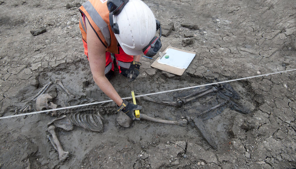
Archaeologists excavating a site along with the Thames Tideway Tunnel—a massive pipeline nicknamed London’s “super sewer”—have revealed the skeleton of a medieval man who literally died with his boots on.
“It’s extremely rare to discover any boots from the late 15th century, let alone a skeleton still wearing them,” says Beth Richardson of the Museum of London Archaeology (MOLA).
“And these are very unusual boots for the period—thigh boots, with the tops, turned down. They would have been expensive, and how this man came to own them is a mystery. Were they secondhand? Did he steal them? We don’t know.”
Unearthing skeletons amid major construction projects is not unusual in London, where throughout the centuries land has been reused countless times and many burial grounds have been built over and forgotten.
However, archaeologists noticed right away that this skeleton was different. The position of the body—face down, right arm over the head, left arm bent back on itself—suggests that the man was not deliberately buried.
It is also unlikely that he would have been laid to rest in leather boots, which were expensive and highly prized. In light of those clues, archaeologists believe the man died accidentally and his body was never recuperated, although the cause of death is unclear.
Perhaps he fell into the river and could not swim. Or possibly he became trapped in the tidal mud and drowned.
Sailor, fisherman, or “mudlarker”?
500 years ago this stretch of the Thames—2 miles or so downstream from the Tower of London—was a bustling maritime neighbourhood of wharves and warehouses, workshops and taverns.
The river was flanked by the Bermondsey Wall, a medieval earthwork about fifteen feet high built to protect riverbank property from tidal surges.
Given the neighbourhood, the booted man may have been a sailor or a fisherman, a possibility reinforced by physical clues.
Pronounced grooves in his teeth may have been caused by repeatedly clenching a rope. Or perhaps he was a “mudlarker,” a slang term for those who scavenge along the Thames muddy shore at low tide.
Grooves in the teeth of the booted man
The man’s wader-like thigh boots would have been ideal for such work.
The boots discovered on the skeleton of a medieval man during Tideway excavations
“We know he was very powerfully built,” says Niamh Carty, an osteologist, or skeletal specialist, at MOLA.
“The muscle attachments on his chest and shoulder are very noticeable. The muscles were built by doing lots of heavy, repetitive work over a long period of time.”
It was work that took a physical toll. Albeit only in his early thirties, the booted man suffered from osteoarthritis, and vertebrae in his back had already begun to fuse as the result of years of bending and lifting.
Wounds to his left hip suggest he walked with a limp, and his nose had been broken at least once. There is evidence of blunt force trauma on his forehead that had healed before he died.
“He did not have an easy life,” says Carty. “Early thirties was middle age back then, but even so, his biological age was older.”
The examination is continuing. Isotope investigation will shed light on where the man grew up, whether he was an immigrant or a native Londoner, and what kind of diet he had.
“His family never had any answers or a grave,” says Carty. “What we are doing is an act of remembrance. We’re allowing his story to finally be told.”
Shackled Skeletons Unearthed in Greece Could Be Remains of Slaughtered Rebels
Phaleron is a small town just four miles south of Athens that most visitors are unaware of. In addition to being a port of Athens in classical times, Phaleron has one of the largest cemeteries ever excavated in Greece, with over 1,500 skeletons. Phaleron, which dates from the 8th to 5th centuries BC, is critical for our understanding of the growth of the Greek city-state. And, in particular, for comprehending the associated brutality and subjugation.
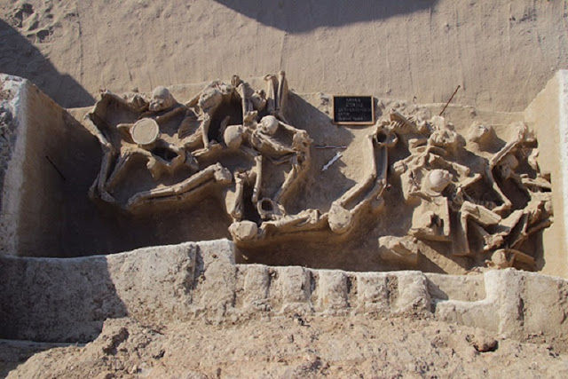
Mass burial of 12 individuals with their hands tied at their backs, from 8th-5th BC Phaleron, Greece
People were forced face-down into a pit with their hands shackled behind their backs in two mass burials at Phaleron. An international team of archaeologists is cleaning, documenting, and examining the Phaleron skeletons to learn more about these deviant burials and their relationship to the Greek state formation.
Excavation at the site began nearly a century ago, with a mass grave – often referred to as containing the “captives of Phaleron” because of the presence of metal handcuffs – excavated by the Greek Archaeological Service.
But large-scale excavation of almost an acre of Phaleron was carried out between 2012-2016 by the Department of Antiquities of the Hellenic Ministry of Culture, led by archaeologist Stella Chrysoulaki.
The modern excavation garnered massive publicity in Greece because of its scale and funding from the Stavros Niarchos Foundation Cultural Center, but little news has trickled out in the English-language media.
An archaeological excavation was careful and detailed, with conservators on-site and with several skeletons removed in blocks for future micro-excavation. Digitization of the archaeological field records, photographs, and maps is done, but this is just the beginning for the skeletons themselves, whose preservation and analysis has to be done by specialists in bioarchaeology and forensic anthropology.
Example of a prone burial from 8th-5th BC Phaleron. The prone position and limb disorder indicate some sort of deviant burial
There is significant variation in how people were buried at Phaleron. Most were interred in simple pit graves, but nearly one-third are infants and children in large jars, about 5% are cremations complete with funeral pyres, and there are a few stone-lined cist graves. One individual was even buried in a wooden boat used as a coffin – the fact that this lasted nearly three millennia shows that preservation at the site is remarkably good.
The shackled skeletons, easily the most compelling remains from Phaleron, have received researchers’ attention for decades, as they are among the very few instances of shackled deaths in the ancient world and could indicate punishment, slavery, or a death sentence. But the study of these “captives” has to take place within the context of the entire cemetery, and analyzing 1,500 skeletons is a massive task.
Taking the lead on the Phaleron Bioarchaeological Project are bioarchaeologist Jane Buikstra, founding director of the Center for Bioarchaeological Research at Arizona State University, and geoarchaeologist Panagiotis Karkanas, director of the Wiener Laboratory at the American School of Classical Studies at Athens. Their immediate goal for the skeletons showcases the crucial link between the excavation of human skeletons and analysis: curation.
Burial in an 8th-5th century BC cemetery at Phaleron, Greece. The burial preserves metal shackles at the wrists, a deviant form of burial
Before the 1,500 skeletons can be made available for researchers to study, each set of remains needs to be cleaned, the bones inventoried, their age-at-death and sex estimated, and basic pathologies recorded. Setting up a database of this magnitude takes time and effort, as does correlating the skeletons with their archaeological context, and it takes significant funding too. That’s where the bottleneck is at the moment. Buikstra has a grant for approximately half the funds for curation of the skeletons but needs a match for the project to move forward.
In the long-term, though, Buikstra is sure that the Phaleron skeletons will give us a window into a critical time in ancient Greek history, just before the rise of the city-state. The research team has four main objectives following the conservation of the skeletons:
Overview of part of the Phaleron cemetery, showing the diversity of burial practices in the 8th-5th c BC
1) To thoroughly investigate the shackled and other deviant burials, including the individuals tossed into mass graves. Are they a casualty of the political upheaval that preceded the rise of Athenian democracy?
2) To study the burials of children, made primarily in pots, to learn more about infancy and childhood in the ancient world. Since children don’t often make it into the historical record, studying their skeletons helps reveal their brief lives.
3) To learn more about people’s diet at this ancient port city, and to find out if its inhabitants succumbed to diseases easily passed through sailors and other travellers from distant lands.
4) To go beyond the analysis of elite individuals buried with elaborate grave goods by focusing on the more simple burials, to shed light on all social classes of ancient Athens.
Buikstra and her team plan to make the project accessible through a website sponsored by the Ephoreia of Piraeus, Western Attica, and the Islands, Ministry of Culture, Greece, and the ASCSA. This website will also include summary blog posts, photos, and preliminary results. Public talks around the U.S. are planned, as well as Wiener Laboratory open-house, school, and museum events in Athens.
Making the database available to researchers around the world is also part of Buikstra’s plan. This will allow bioarchaeologists to use cutting-edge analytical methods, such as ancient DNA and isotope chemistry, in order to tell the important stories of the people of ancient Phaleron.
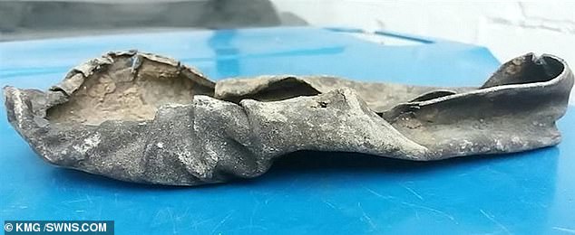
1,000-year-old shoe in the River Thames that was ‘last worn in the run-up to the Battle of Hastings’
A 1,000-year-old shoe has been found intact in the muddy river bed of the River Thames. Steve Tomlinson, 47, was exploring the estuary when he stumbled across the unassuming object protruding from the mudflats. The amateur archaeologist was unaware of its historical significance and was urged by his peers to send it off for expert analysis.
A Scottish institute carefully carbon-dated the shoe and found it be from between 1017 and 1059AD, during the era Anglo-Saxons and Vikings inhabited the British Isles before William the conqueror toppled King Harold at the Battle of Hastings in 1066.
The finding may be one of the last surviving relics from the Viking occupation of Britain before the successful invasion of the French. Results of the laboratory tests found there was a 95.4 per cent probability that the shoe is from between 1017-1059AD.
A Scottish institute carefully carbon dated the shoe (pictured) and found it be be from between 1017 and 1059AD, during the era Anglo-Saxons and Vikings inhabited the British Isles before William the conqueror toppled King Harold at the Battle of Hastings in 1066
Mr Tomlinson, from Birchington, Kent, made the discovery of the leather moccasin in October last year while searching in the estuary and the results have just been returned.
He said: ‘I was out and about just up that area and it was sticking out of a bit of clay mud so I pulled it out.
‘I first thought it was a bit of that but the history of the Thames goes through all the ages so I put the call out to archaeologist and groups and they said ‘oh my God preserve it straight away.’
Mr Tomlinson says he ‘can’t quite believe’ the outcome.
Mr Tomlinson, from Birchington, Kent, made the discovery of the leather moccasin in October last year while searching in the estuary and the results have just been returned. Heel and toe marks are so well preserved they can be seen on the shoe
Steve Tomlinson, 47, (pictured) was exploring the estuary when he stumbled across the unassuming object protruding from the mudflats. The amateur archaeologist was unaware of its historical significance and was urged by his peers to send it off for expert analysis
He added: ‘It is a rare find and amazingly it is still in superb preserved condition, probably due to the fact it was very well preserved in clay along with the sea, keeping it constantly waterlogged.
‘It is so well preserved that the original toe and heel marks can be seen.
‘It just goes to show you never know what lies beneath.
‘I am over the moon with the result.’
The shoes may soon be on display in a museum from a ‘well-known museum’.
When Did Vikings Invade Ireland?
In the 10,000 years since Stone Age cavemen first arrived, the Irish have established distinct cultural regions. Researchers have recently found 23 distinct genetic clusters, separated by geography by comparing mutations from almost 1,000 Irish genomes with over 6,000 from Britain and mainland Europe.
These are most distinct in western Ireland, but less pronounced in the east, where historical migrations have erased the genetic variations. They also detected genes from Europe and calculated the timing of the historical migrations of the Norse-Vikings and the Anglo-Normans to Ireland, yielding dates consistent with historical records.
The Vikings left their genetic footprint in Ireland when they invaded the island, launching their first attack in 795 AD by raiding an island monastery. By the 840s, the Vikings began to establish permanent ship bases along the coastline
The study paints a new and more complex picture of the genetic landscape of Ireland and demonstrates the signatures that historical migrations have left on the modern Irish genome. The Vikings left their genetic footprint in Ireland when they invaded the island, launching their first attack in 795 AD by raiding an island monastery.
The Vikings continued to stage small-scale attacks on unprotected coastal monasteries before sailing to River Shannon in the 830s to steal from inland religious settlements. By the 840s, the Vikings began to establish permanent ship bases along the coastline from which they could plunder all year.
Norse influence in Ireland began to decline by the time of the rise of king Brian Boru (pictured in an imagined depiction)
The Vikings also enslaved some of the Irish people and were able to raid the land by taking advantage of the fact that Ireland was particularly politically fractured.
The Vikings, however, did not conquer the island – by the middle of the 10th century, they failed to control the territory in Ireland. The fractured political system in Ireland worked in the island’s favour – if one ruler was killed, it did not destabilize the entire island.
Norse influence in Ireland began to decline by the time of the rise of king Brian Boru. He sacked the Viking town in Limerick in 968 AD and became the overlord of Cork, Wexford and Waterford. In 1014, the king’s army routed the Vikings and their allies at the Battle of Clontarf outside Dublin, but a small group of Norseman killed the elderly kind as he was praying in his tent after the battle.
The Viking remained in Ireland after agreeing to pay a tribute, but the Viking Age in Ireland didn’t come to a definitive end until the Norman invasion in the 1170s and the last Norse king of Dublin escaped to the Orkney Islands.
500 Year Old Map Was Discovered That Shatters The “Official” History Of The Planet
The past of humanity is a mystery. We know very little, and much of what we believe we know is rapidly changing as new knowledge emerges that challenges our existing paradigm.
Our world is also no stranger to unexplained mysteries, and there are numerous examples of verified phenomena, ancient monuments, books, teachings, understandings, and more that lack any explanation and counter what we’ve already been taught. We are like a race with amnesia, able to put together small bits and pieces of our history yet unable to fit it all together. There are still many missing pieces to the puzzle.
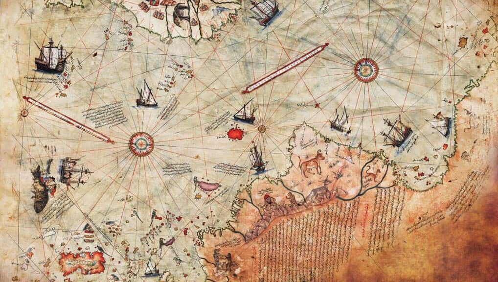
One great example is the Piri Reis map, a genuine document that was copied at Constantinople in AD 1513 from older documents and discovered in 1929. It focuses on the western coast of Africa, the eastern coast of South America, and the northern coast of Antarctica. It was drawn by Admiral Piri Reis of the Ottoman era, a well-known historical figure. He made a copy of the map, which was originally drawn based on documents that date back to at least the fourth century BC, and on information obtained by multiple explorers.
Surviving fragment of the Piri Reis map showing the Central and South American coast. The appended notes say “the map of the western lands drawn by Columbus”
Why the Map Is So Compelling
One of the most compelling facts about the map is that it includes a continent that our history books tell us was not discovered until 1818.
Secondly, the map depicts what is known as “Queen Maud Land,” a 2.7 million-square-kilometre (1 million sq mi) region of Antarctica, as it looked millions of years ago. This region and other regions shown on the map are thought to have been covered completely in ice, but the map tells a different story, showing them free of ice, which suggests they passed through a long ice-free period that may not have ended until around six thousand years ago, conflicting with current research on these areas. Today, geological evidence has confirmed that this area could not have been ice-free until about 4000 BC.
Official science has been saying that the icecap that covers the Antarctic is millions of years old. The Piri Reis map shows that the northern part of that continent had been mapped before the ice did cover it, which means that it was mapped a million years ago — but that’s impossible since mankind did not exist at that time. Quite the conundrum, isn’t it?
Professor Charles Hapgood, who was a university history professor, wrote to the United States Air Force Reconnaissance Technical Squadron (SAC) and they also confirmed that “this indicates the coastline had been mapped before it was covered by the ice-cap.” They also went on to state that “we have no idea how the data on this map can be reconciled with the supposed state of geographical knowledge in 1513.”
Here’s what Hapgood had to say about it in his book Maps of the Ancient Sea Kings:
It appears that accurate information has been passed down from people to people. It appears that the charts must have originated with a people unknown and they were passed on, perhaps by the Minoans and the Phoenicians, who were, for a thousand years and more, the greatest sailors of the ancient world. We have evidence that they were collected and studied in the great library of Alexandria (Egypt) and that compilations of them were made by the geographers that worked there.
Furthermore, the map is very detailed and includes mountain ranges in the Antarctic that were not even discovered until 1952.
“His idea is original, of great simplicity, and – if it continues to prove itself – of great importance to everything that is related to the history of the Earth’s surface.”
– Einstein on Hapgood’s interpretations of the map (From a forward Einstein wrote for Hapgood in one of his books)
Hapgood and mathematician Richard W. Strachan have also provided more mind-boggling information. For example, a comparison with modern-day photographs taken from satellite images shows remarkable similarities; the originals of Piri Reis’ maps might well have been aerial photographs taken from a very high height. I’ll let you think about that for a second. How is that possible for a map that was made millions of years ago?
“A spaceship hovers high above Cairo and points its camera straight downward. When the film is developed, the following picture would emerge: everything that is in a radius of about 5,000 miles of Cairo is reproduced correctly because it lies directly below the lens. But the countries and continents become increasingly distorted the farther we move our eyes from the centre of the picture.
Why is this? Owing to the earth’s spherical shape, the continents away from the centre‘ sink downward.’ South America, for example, appears strangely distorted lengthways, exactly as it does on the Piri Reis maps! And exactly as it does on the photographs taken from the American lunar probes.”
The fact that this ancient map could have been made with some sort of aerial technology is quite a thought, isn’t it? Even if this isn’t an option, who had the technology to undertake such an accurate geographical survey in Antarctica two million years ago? How would they have known to detail the map as if it were taken from above, with knowledge about the Earth’s shape?
It remains a mystery how the Sumerians, Mayans, and others were aware of celestial bodies in space, for instance, that are impossible to detect without modern technology and could make calculations based on that awareness.
This map is another example of just such a mystery and suggests that the existence of some sort of ancient advanced civilization, with all the tools (or possibly more) of modern-day civilization, is indeed plausible.
For more detailed information regarding this truly fascinating map, I suggest you check out Graham Hancock’s Fingerprints of the Gods.
I’d also like to mention that this map is part of a very large body of evidence suggesting that extremely intelligent, very advanced ancient civilizations once inhabited the Earth.
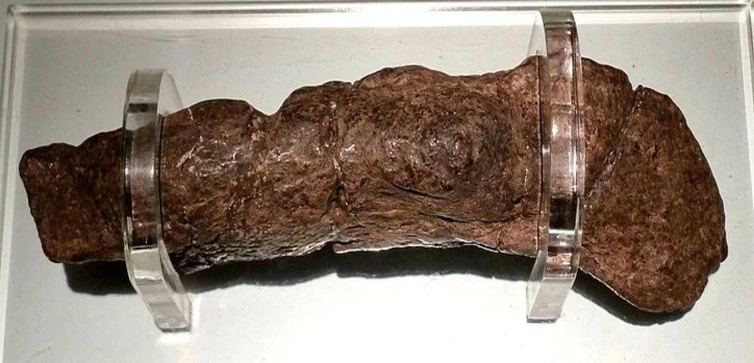
This is the largest fossilized human turd ever found
Sometimes, scientists really are talking sh*t! The proof is in this fossilized excrement, which dates back to the 9th century. It was discovered about 40 years ago, and is famous for being the most expensive poo in the world!
The fossil is known as the Lloyds Bank Coloprite, the word “Coprolite” simply meaning fossilized dung. The rest of its name refers to the fact that it was found in 1972 by construction workers during the building of a Lloyds TSB branch in York, in the northwest of England.
Put simply, this is a fossilized human turd. Not only that but the largest and – bizarrely – most valuable on record.
It dates back to approximately the 9th century and the person responsible is believed to be a Viking. It currently rests at the Jórvík Viking Centre in the city of York, England.
Jórvík was the Viking name for York, with the Center part of an area that has yielded numerous treasures. Whether the Coprolite can be described as treasure is a question for the ages. That said, the details are fascinating.
The reason it’s named after Lloyds Bank isn’t some weird corporate branding exercise. The hefty deposit, measuring 8″ x 2″ (20 cm by 5 cm), was found beneath the site of the famous bank in 1972. And here’s a fun fact for the day – “Coprolite” means fossilized human faeces! Paleofeces is also a term used to describe ancient human droppings found as part of archaeological expeditions.
This is one mighty archaeological achievement. The Australian Academy of Science observed in 2017, “Human coprolites are very rare and tend to only be preserved in either very dry or frozen environments, however, samples have been found that date back to the Late Paleolithic—around 22,000 years ago.”
The Lloyds Bank coprolite: fossilized human faeces dug up from a Viking site in York, England. It contains large amounts of meat, pollen grains, cereal bran, and many eggs of whipworm and maw-worm (intestinal parasites). It is on display at the Jorvik Centre in York.
For a complete specimen to last this long is awe-inspiring, if not exactly need-to-know information. How do they know it came from a Viking? The ingredients that went into the epic production provide some clues.
“He was not a great vegetable eater,” wrote the Guardian in 2003, “instead of living on large amounts of meat and grains such as bran, despite fruit stones, nutshells and other stools containing matter from vegetables such as leeks being found on the same site.”
Human paleofeces from the Neolithic site Çatalhöyük, Turkey.
That all sounds normal enough, however the Viking’s bowels were also packed with creepy crawlies.
In 2016, the website Spangenhelm referred to “the presence of several hundred parasitic eggs (whipworm)”, which “suggests he or she was riddled with intestinal parasite worms (maw-worm).”
These unwanted invaders can cause serious health problems. The BBC describes conditions such as “stomach aches, diarrhoea, and inflammation of the bowel.” Get enough worms and things get worse, as “symptoms may simulate those of gastric and duodenal ulcers.”
Parasites aren’t known for standing still either. Adults “can migrate from the intestine and enter other organs where they can cause serious damage, even moving into such places as the ear and the nose of unfortunate suffers.”
On a more agreeable note, the malodorous museum piece has been valued at an extraordinary $39,000. No less a publication than the Wall Street Journal reported on the coprolite in 1991, with one source claiming it was “as valuable as the Crown Jewels”.
British TV company Channel 4 delved deeper into the desiccated dropping in 2003, giving viewers an insight into what an ancient turd can reveal about the past. According to them, “if we ever succeed in extracting and analyzing DNA from the excrement, it could be possible to determine the kind of flora that this Viking had in his intestines.”
Those thinking that the excrement-based exhibit might lead to a boring existence are wrong. In fact, it’s faced potential disaster. 2003 is a significant year for the Lloyd’s Bank Coprolite, as it had a brush with destruction courtesy of an unsuspecting educator.
A Guardian report from the time writes that “all was well until two weeks ago when its display stand collapsed in the hands of an unfortunate teacher and, crashing to the floor, the rock-like lump broke into three pieces.”
Talk about a potentially sticky situation. What happens when fossilized faeces is damaged? It’s carefully glued back together of course! This saw the turd reconstructed as if it were a Roman vase or Aztec plate.
With careful maintenance, it’s hoped the Lloyds Bank Coprolite will go on for many years to come. For the individual whose historic diet resulted in the artefact, it was simply a bodily function. Centuries on, experts are flushed with their success in discovering it.
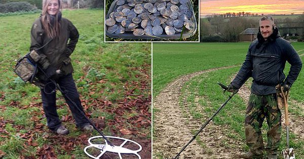
A couple find £5,000,000 in one of biggest ever treasure hoards
In an area in Somerset, in the West of England, a pair of metal detectorists found their existence when they uncovered a hoard of ancient coins worth about 6 million dollars. The historical discovery, which has been deemed to be one of the greatest hidden treasures in the UK, is to be revealed in the British Museum.
These coins could be worth up to £5,000,000 after being dug up in a field in north east Somerset
The 2,571 Anglo-Saxon and Norman coins were unearthed by Adam Staples ‘ and Lisa Grace Treasure hunters when they searched farmland with their trusty metal detectors.
The couples have described the hoard as “stunning” and “absolutely mind-blowing” in an interview with Treasure Hunting Magazine.
Adam Staples and partner Lisa Grace unearthed the ‘once in a lifetime’ find of almost 2,600 ancient coins that date back 1,000 years. Their discovery came on a farm in the northeast of Somerset.
They reported their find to the authorities as required by UK law, and the coins were soon sent to the British Museum for evaluation.
The British Museum has been assessing the find for the past seven months and is due to reveal more information about the coins to the public on Wednesday.
A spokesperson for the institution confirmed to the Daily Mail that the “large hoard” was handed over as possible treasure and that it appears to be “an important discovery.”
Under the UK’s 1996 Treasure Act, if a find is officially declared treasure, it must first be offered for sale to a museum at a price set by the British Museum’s Treasure Valuation Committee. If no museum can raise the money to acquire the coins, they can then be offered for sale at auction.
The owner of the land where the coins were found is entitled to half of the proceeds. The metal detectorists are keeping the exact location of their discovery under wraps, although the trove is called the Chew Valley Hoard after an area in North Somerset.
William the Conqueror (left) and Harold II coins. Photo by Pippa Pearce. Copyright the Trustees of the British Museum.
A coin expert at the London auctioneers Dix Noonan Webb has valued the coins at around £5 million ($6 million).
They include mint-condition silver King Harold II pennies, coins from the reign of William the Conqueror, which could be worth as much as £5,000 ($6,000) each, as well as pieces minted by previously unknown moneyers.
The King Harold II coins are particularly rare due to his short reign. The last Anglo-Saxon king was on the throne for just nine months before he died during the Battle of Hastings in 1066.
The expert said that the hoard may prove too pricey for museums, which might have to launch an appeal for sponsors to raise funds to acquire them.
The coins would have belonged to a wealthy person who probably buried them for safekeeping at some point after the Norman Invasion of 1066 and probably before 1072.
The biggest collection of buried treasure ever discovered in the UK was the Staffordshire Hoard of Anglo-Saxon gold and silver metalwork, but this latest find could worth $1 million more, and have as great or even more historic value.