Category Archives: EUROPE

‘Sunken Atlantis Pyramid’ Discovered off Azores Coast in Portugal

‘Sunken Atlantis Pyramid’ Discovered off Azores Coast in Portugal

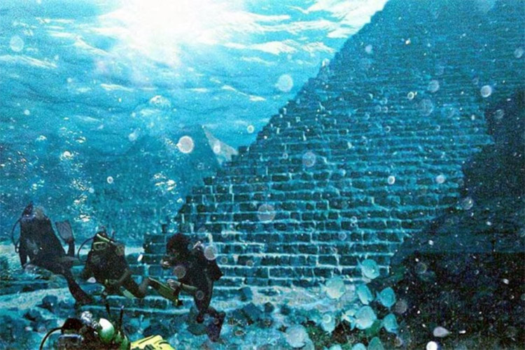
According to an official Portuguese news article, the Portuguese Navy is exploring a massive underwater pyramid close to the Azores. If this is the abandoned city of Atlantis or whether the pyramid is of extra-terrestrial origin is still debated by some people.

Some other more grounded scholars claim this may be part of a larger map incorporating the pyramids found at Giza in Egypt.

A pyramid was accidentally found under the water, close to the Azores when a local sailor was looking for good fishing grounds. He used digital scanning devices to help him locate the Pyramid.

A huge pyramid had been discovered off the Azores islands by Portuguese amateur sailor Diocletian Silva.

The 9 islands that make up the Azorean archipelago we now know as the Azores were discovered uninhabited by the Portuguese in 1427. In recent years archaeologists have discovered ancient rock art on the island of Terceira, which they believe to be many thousands of years old.

They have also discovered a  variety of ancient archaeological remains on all nine islands. They have been identified as an epigraph from Roman times, Carthaginian sanctuaries, cave art, and megalithic structures. It would seem there is a lot more history to these islands that pre-date 1427.

The underwater pyramid was discovered by Diocleciano Silva between the islands of Terceira and São Miguel. It is said that the structure is perfectly square and oriented by the cardinal points.

Using current GPS digital technology it is estimated that the pyramid is around 60 meters high and has a base of nearly 8,000 square meters. That is pretty big!

The Portuguese Hydrographic Institute of the Navy is studying the pyramid data to determine whether it is man-made, naturally occurring, or even something more interesting. Extra-terrestrial perhaps? I wonder if Mulder and Scully are investigating!

The pyramid is found in an area of the Atlantic that has been covered by water for around 20,000 years. That time coincides with the last great ice age of the northern hemisphere where the glaciers started melting 2,000 years earlier. Whoever was living there before the ice age, human or not was probably responsible for building the pyramid.

So far the Portuguese Navy has not determined the origins of the pyramid. It is surprising that this has not been reported before or even discovered before. Was it kept secret or had it sat there for years unnoticed?

What is hard to believe is that the area is heavily studied for its volcanic activity by the NOAA, which studies volcanic behavior. You would have thought that they would have found the pyramid through sonar imaging.  So was it kept secret until Diocleciano Silva found it and went public or is he the first person to actually find this incredible mystery?

Some people even think it might not be real and is instead a hoax but that theory seems unlikely especially as pyramids are evident all across the globe with new ones been discovered every now and then.

This is the actual pyramid as shown as reading from a high-tech scanning device.

Archaeologists from the Portuguese Association of Archaeological Research have found evidence on Pico Island that suggests humans did live in the area many thousands of years before the Portuguese discovered the uninhabited Azores.

This adds support to the idea that an ancient civilization was there at the time to build the huge pyramid. There is still no explanation as to who created the rock art found on the islands or why.

So who did build the underwater pyramid? Was it built by a great ancient civilization that spanned the globe from South America to Africa and the East?

Pyramids are found across many continents, was this one giant civilization? Is this the fabled lost continent of Atlantis that connected the distant civilizations together? Or is it not man-made and perhaps Extra-terrestrial in origin?

'Sunken Atlantis Pyramid' Discovered off Azores Coast in Portugal
Here is the original Portuguese news report along with English subtitles (Not the best I may add) for those who wish to check the validity of the claims and the story.

The Azores themselves are a chain of 9 volcanic islands in three main groups situated 930 miles west of Lisbon. They sit around the fault lines between the tectonic plates of the North American, Eurasian and African continents. The energetic qualities of that area are a great place to have a pyramid. Pyramids are supposed to collect and concentrate energy in positive ways.

This video shows the spot where the pyramid might be along with some discussion about the validity of the claims.

The coordinates of the pyramid have not been released to the public, why? We are not sure maybe it is to prevent tomb robbers and Lara Croft from visiting or maybe there are other important secrets that they need to keep quiet for now. What is believed is that there could be two more pyramids in the area and that there could be a design link with those found in Egypt which forms a land based representation of a star constellation.

Adding to the theory that these pyramids were created by people from the stars or that our ancients knew we were created by aliens in ‘their image’ and not native to this planet. These giant star maps could be the real clue to the history of mankind’s origin.

A interesting video about the underwater pyramid and other possible structures in and around the Azores, the Canary Islands, Antarctica, and the Atlantic sea.

Hoard of silver and gold coins unearthed in central Hungary

Hoard of silver and gold coins unearthed in central Hungary

An attack by the Ottoman Army in the 16th century may have caused panicked Hungarians to bury a stash of precious silver and gold coins. Today, on a modern-day farm in Hungary, archaeologists have discovered this buried treasure.

In 2019, archaeologists discovered 150 ancient coins in Újlengyel, a Hungarian village that’s about 31 miles (50 kilometers) southeast of Budapest.

Spurred by this discovery and equipped with metal detectors, the archaeologists returned to the site at the end of December 2020 to look for other treasures, according to a Facebook post from the Ferenczy Museum in Hungary.

Hoard of silver and gold coins unearthed in central Hungary
Archaeologists discovered thousands of ancient coins buried on a Hungarian farm.

Balázs Nagy, the museum’s numismatist, or coin expert, led the two-day expedition, with help from volunteers with the Community Archaeological Association.

On a nearby hill, the archaeologists dug through a small shaft and unearthed a vessel that was broken in half, likely due to plowing, according to a statement. The vessel had originally held thousands of ancient coins that were found strewn about the shaft.

The newly discovered coin collection consisted of nearly 7,000 silver coins and four gold coins, according to the post.

The discovery in Újlengyel of hidden coins is a spectacular find, comprising seven thousand silver and four gold medieval coins in Hungary.

At the time the coins were probably buried, around 1520, they would have been worth enough to buy seven horses; and by today’s standards, they would be enough to buy a luxury car, according to the post.

The oldest coin is a silver denarius, or a Roman silver coin of Roman emperor Lucius Verus, who ruled from A.D.161 to A.D. 169. The newest coins in the hoard date to the time of Louis II, who ruled Hungary and Bohemia from 1516 to 1526.

The four gold coins, which were issued during the reign of Matthias I, the king of Hungary from 1458 to 1490, were hidden under a piece of fabric in the lining of the vessel, according to the statement.

Other finds included a rare coin issued by Pope Pius who ruled from 1458 to 1464 and silver coins issued during the reigns of several other 15th and 16th century rulers.

It’s unknown why people buried these coins, but the archaeologists hypothesize that Hungarians may have buried them during an attack from the Ottoman Empire in 1526.

“Treasures of this magnitude related to the Turkish devastation following the battle of Mohács are rare in Hungary,” according to a Facebook post.

(The Ottoman Empire, led by Suleiman the Magnificent, defeated Hungary and its allies in the Battle of Mohács on Aug. 29, 1526; this battle marked the end of the Hungarian monarchy and opened the way for Turkish and Habsburg rule of the region, according to Britannica.)

The museum is planning to continue to explore this site in search of other historical treasures.

The Extraordinary Discovery of a 1,000-Year-Old Chinese Coin in the UK May Give Proof of a Global Medieval Trade Route

The Extraordinary Discovery of a 1,000-Year-Old Chinese Coin in the UK May Give Proof of a Global Medieval Trade Route

A newly discovered medieval Chinese coin, the second ever found in England, points to the possible existence of a vast medieval trade route spanning much of the Eastern hemisphere.

Discovered via a metal detector in a field in Hampshire, the copper-alloy coin dates to the Northern Song dynasty, between 1008 and 1016, and would have likely circulated through the 14th century, according to the Times.

The find follows the discovery of a similar coin, dated from 1068 and 1077, in Cheshire in 2018.

The Extraordinary Discovery of a 1,000-Year-Old Chinese Coin in the UK May Give Proof of a Global Medieval Trade Route
A copper-alloy Chinese coin of the Northern Song emperor Zhenzong, dated 1008–16, found near Petersfield, Hampshire.

“If they did arrive at some point in the medieval period, then they would help illustrate the existence of very long-distance, indirect trading networks and contacts in this era,” Cambridge historian and archaeologist Caitlin Green, who wrote a blog post about the find, told Artnet News in an email.

When the Chinese coin first turned up, researchers at the British Museum wrote that “it is doubtful that this is a genuine medieval find (i.e. present in the country due to trade and lost accidentally) but more likely a more recent loss from a curated collection.”

The distribution of archaeological and textual evidence for the presence of medieval Chinese pottery (black open circles) and coins (blue dots) west of India, set against the maximum extent of the Mongol Empire in the late thirteenth century in red; the map is based on Whitehouse 1972, Cribb and Potts 1996, Vigano 2011, Vigano 2014, Zhao 2015, Meicun and Zhang 2017, Василев 2017.

But now that there’s been a second discovery of a similar nature, Green believes that conclusion has been called into question, and that the case for medieval trade links between China and the UK has become much more convincing—especially since both coins turned up in areas where medieval and early post-medieval material has previously been discovered.

“We have only a handful of finds of material from East Asia from pre-modern England,” Green said. “But interestingly, one of the other pieces is a piece of imported Chinese pottery from a 14th-century excavated context at Winchester, which is only 20 miles from the new coin find.”

A Northern Song dynasty coin from China, minted during the Xining reign between 1068 and 1077, found in Cheshire.

And Green has found other evidence of exchange between the two distant lands. There are historical accounts of Englishmen in the Mongol empire in the 13th century, and of Mongol envoys visiting England in 1264. Antique Chinese artifacts have also been found in other parts of Europe, Africa, and the Middle East.

Nevertheless, Green cautioned that these discoveries may have made their way to the UK in more recent times, especially since these were “metal-detected finds and not excavated from sealed archaeological contexts.”

“If there’s no other context, I’d suggest it’s just a random coin-find,” Helen Wang, who identified the coin for the UK’s Portable Antiquities Scheme, told the organization.

“Chinese coins were taken on ships from China to [southeast] Asia, South Asia, the Middle East, so this coin could have come that way (at any date after 1008) or fallen out of a pocket not so long ago.”

Sultan’s Grave Discovered in Eastern Turkey

Sultan’s Grave Discovered in Eastern Turkey

The graves of the SeljukThe Anadolu Agency reports that the grave of Kilij Arslan I, a Seljuk sultan who reigned from A.D. 1092 to 1107, was discovered during investigations ahead of construction work in eastern Turkey by a team of researchers from Dicle University.

The team members also found the grave of the sultan’s daughter, Saide Hatun.

Sultan of Rum Kılıç Arslan I and his daughter Saide Hatun were uncovered in southeastern Diyarbakır province following a nine-day excavation.

The archaeological site of the graves of Seljuk Sultan of Rum Kılıç Arslan I and his daughter Saide Hatun in Diyarbakır, southeastern Turkey.

After conducting archival research, Dicle University (DÜ) established a commission to find Kılıç Arslan I’s grave in Diyarbakır. Headed by the vice-rector of DÜ, professor Ahmet Tanyıldız, the commission included professor Irfan Yıldız, associate professor Oktay Bozan, associate professor Aytaç Çoşkun and academic Salih Erpolat.

Taking into consideration all graveyards in the Silvan district of Diyarbakır, the commission focused its work on two gravesites in Orta Çeşme Park in line with the data obtained from their research. After nine days of work, the team uncovered the Seljuk sultan’s final resting place on Tuesday.

Speaking to reporters, DÜ Rector Mehmet Karakoç said they had been unable to pinpoint the exact location of the grave in the past but knew it was somewhere in the Silvan district.

“The discovery of the grave will bring a different perspective to historical events in terms of both Silvan and Diyarbakır’s history,” Karakoç said.

Coşkun noted that the team dug 2 meters deep (6.6 feet) across a 35-square-meter (42-square-yard) area during their work to find the grave.

“The area on which we work featured the grave of the most important ruler of the Sultanate of Rum. Therefore, we studiously sustained our work day and night,” he added.

Kılıç Arslan I succeeded Suleiman ibn Qutulmish, who founded the sultanate in 1092. As the second Anatolian Seljuk sultan, he was also the first Muslim commander to fight against the Crusaders. He defeated the Crusaders in three battles during the Crusade of 1101 and went on to conquer much of eastern Anatolia from the Danishmends.

4,000 Years old Anglo-Saxon Settlement and Cemetery Unearthed in England

4,000 Years old Anglo-Saxon Settlement and Cemetery Unearthed in England

The Northampton Chronicle & Echo reports that an Anglo-Saxon settlement and cemetery, and Bronze Age barrows and burials, were discovered in England’s East Midlands during an archaeological investigation conducted by researchers from the Museum of London Archaeology ahead of a development project.

Traces of more than 20 structures were unearthed at the Anglo-Saxon settlement site. Weapons, cosmetic kits, combs, thousands of beads, some 150 brooches, 75 wrist clasps, and 15 chatelaines were recovered from the more than 150 Anglo-Saxon burials. 

The site was excavated as part of pre-construction planning requirements at Overstone Farm where Barratt and David Wilson homes intend to build two to five-bedroom homes, a school and amenities, as part of a new housing development.

Archaeologists uncovered the site during pre-construction planning requirements.

Jewellery, weapons and more were found.

An archaeology firm – Museum of London Archaeology (Mola) – was appointed and over the course of 12 months, the archaeologists undertook detailed excavation and recording across a total of 15 hectares.

The work revealed 154 Anglo-Saxon burials, many containing grave goods including weapons, beads and brooches. Simon Markus, project manager at MoLA, said: “The Overstone site contains by far the biggest Anglo-Saxon cemetery ever found in Northamptonshire.

Jewellery, weapons and more were found.

“It is also rare to find both an Anglo-Saxon settlement and a cemetery in a single excavation.

An overview of the site in Overstone.

4,000 Years old Anglo-Saxon Settlement and Cemetery Unearthed in England
An overview of the site in Overstone.

“The excavations will help us understand the way people lived in both the Anglo- Saxon period, around 1,500 years ago as well as the Bronze Age, nearly 4,000 years ago.

“The human remains will tell us about diet, health and even the origins of the people themselves whilst their buildings can teach us what their day-to-day lives were like and how they utilised the local landscape in these two different periods.”

Jewellery found on the site included roughly 150 brooches, 15 rings, 2,000 beads, 75 wrist clasps and 15 chatelaines – decorative belt hooks.

Other findings included weapons such as spears and shields and everyday items like cosmetic kits and combs.

The site also contains a previously unknown Anglo-Saxon settlement of 22 structures, with 20 more Anglo-Saxon buildings scattered around the site, together with earlier prehistoric evidence including three Bronze Age round barrows, 46 prehistoric burials, and four Bronze Age buildings.

John Dillion, managing director at Barratt and David Wilson Homes South Midlands, said: “We’re blown away by the findings at our site in Overstone and have enjoyed learning more about what the land was previously used for.

“It is amazing to think that settlers have been building homes on this site for around 4,000 years, and we hope to continue this long-standing tradition with our new and already flourishing community.”

All of the findings from the excavations have been removed from the site and are now being analysed by MOLA’s specialist teams.

The Unique Architectural Heritage Of Icelandic Turf Houses that Hidden In The Landscape

The Unique Architectural Heritage Of Icelandic Turf Houses that Hidden In The Landscape

Memorable, popular, and rumored to be the inspiration for Tolkien’s hobbit holes, turf houses are a rare form of home for the people who live in difficult climates.

For millennia, they have existed, and although layouts and materials may have changed, the basic format remains the same wood and stone frames surrounded by the Icelandic landscape’s most plentiful material: turf. In Iceland, where turf houses were the most common housing as late as the 1960s, the structures were practical and well-suited for the difficult weather and lack of timber.

The people responsible for bringing the knowledge of turf houses were the very first settlers and themselves from another cold, difficult climate – the Vikings.

When the Vikings arrived in Iceland in 874 AD, it wasn’t as barren as it appears today – in fact, 25-40% of the island was covered in forest, mainly birch trees, though they were on the short side due to lack of light and low temperatures. 

But the new inhabitants cleared the forests for sheep grazing, agriculture, shelter, and firewood. Tree regeneration was inhibited by all the grazing and thus, the Vikings deforested Iceland.  So where did they get the wood for their houses after they used up the forest? Driftwood and shipwrecks made up the deficit.

The Vikings built communal longhouses, often sharing one large room with dozens of people and occasionally, animals.  Body heat was a very important tool for not freezing to death during the long dark winter, so inhabitants slept all in the same room with two or more per bed. 

Turf longhouses varied in size depending on the wealth of the farmer or clan, and occasionally outbuildings like sheds and privies were also built.

The building method is genius.

First, a hole was dug a few feet down to where the ground doesn’t freeze.  Then a stone footprint was laid using the flattest stones possible – this kept the wood from touching the damp ground and helped prevent rot. 

A wooden frame was then erected on top of the stone footprint; the posts and beams were held together using notches and pegs, and a mat of small branches was laid over the roof beams to create airflow between the beams and the turf. 

The turf was cut directly out of the ground using special tools and laid out to dry; then the turf “bricks” – held together by the root mass of the plants therein – were laid in two courses around the wood frame, with dirt and gravel compacted between the layers. 

Turf bricks also covered the roof at a steep angle to facilitate water runoff.  The resulting walls were extremely thick and provided excellent insulation and surprising water-tightness.

Viking houses included some very interesting features, like elaborate carved front doors with complex locks and holes for shooting arrows at attackers, and a sleeping closet for the master of the house and his wife that locked from the inside for extra protection against invaders. 

Archaeological evidence suggests that more than the longhouse was communal – the turf outhouses featured group seating!

While the Viking turf houses undoubtedly fared well against Iceland’s notorious cold, damp, and dark weather, they did have some downsides. 

Mice and lice often lived in the turf, and very bad storms could sometimes peel up the roofs.  Turf houses also required a lot of maintenance, and depending on the severity of the winter needed to be re-turfed every 20 or so years.

By the 14th century, Viking style longhouses had given way to smaller, specialized buildings that were connected by tunnels to conserve heat.  By the late 18th century, the burstabær style was the most popular, introducing wooden ends, or a wooden face with the back built into the side of a hill. 

Many houses in this style still stand and have become the iconic Icelandic turf house.  They remained the most common form of housing in Iceland until the 20th century when urbanization and modernization took the country by storm.  Within 30 years, Icelanders had made the change to modern houses and city living, and the last full-time residents of turf houses moved out in the 1960s.

Today you can visit several turf houses, most of which have been restored and incorporated into the National Museum of Iceland, though some families have privately restored their ancestral homes.

Once a common skill, knowledge of turf house construction is now relegated to a handful of specialized craftsmen doing restoration and educational work. 

But the influence of turf houses lives on: architecture firms in Iceland and abroad are rediscovering the appeal of the original “green” buildings, with their insulating properties and use of local materials.  Besides being strong and practical, turf houses are cute – especially when the roofs are in bloom.

Manchester Victorian baths uncovered under the car park

Manchester Victorian baths uncovered under the car park

Remnants from one of the earliest Victorian bathhouses have been unearthed beneath a car park. The “stunning” remains of Mayfield Baths, where mill workers took baths and washed their clothes, were found by archaeologists in Manchester.

The ornate tiles of the Mayfield baths, whose pools measured nearly 20 meters, were found in “stunning” condition beneath a car park 164 years after it opened.

The building, a grand Italianate design set in the heart of Manchester’s booming “Cottonopolis” district, was demolished after being bombed in the second world war but the remains of its swimming pools have been discovered by archaeologists from the University of Salford.

Manchester Victorian baths uncovered under the car park
Archaeologist Steve Tamburello inspects segments of tiles from one of the pools that were part of Mayfield baths.

The bathhouse, which opened in 1857, was a vital public amenity that served generations of Mancunians, most of whom worked in the surrounding print and textiles factories.

The area behind Manchester Piccadilly station has mainly been derelict for years but is undergoing redevelopment as part of plans to build 1,500 homes, retail, leisure and office space, as well as a 6.5-acre park – the first in the city for 100 years. The redevelopment will also include a few new car parks to make up for the one that has been demolished, the plan is to have a bigger car park but only one of them that would serve the majority of the facilities in close proximity. It’s safe to say there are going to be many new line paint machines procured ready for the development of the new car park.

Graham Mottershead, the project manager at Salford Archaeology, said: “The Mayfield bathhouse is a fascinating example of the social and public health advancements that came about during the Industrial Revolution.

“As the city’s population boomed with factory workers, crowded and substandard living conditions gave rise to the spread of cholera and typhoid. For those living and working around Mayfield, the Mayfield baths would have been a vital source of cleanliness and hygiene.

The ornate tiles from the Mayfield baths will be preserved for future use, developers said.

“The sheer pace of change and innovation during the Industrial Revolution means many advancements were not recorded.

Excavations like this help us to learn a great deal about what is arguably the most important period of human history and, in the case of Mayfield, a location that is so very relevant to the heritage of the people of Manchester.”

The Mayfield Partnership, the public-private company behind the redevelopment, said it would preserve the ornate tiles from the bathhouse and use them in future.

It plans to name one of the new commercial buildings after George Poulton, who became famous in the 1850s as a promoter of public health at the Mayfield baths.

The remains, which were uncovered by painstaking hand-digging as well as machine excavation, will be used to form a detailed record of the bathhouse by combining the findings with historical documents and digital drawings.

300,000-Year-Old Wooden Throwing Stick Found in Germany

300,000-Year-Old Wooden Throwing Stick Found in Germany

In Germany, a 300,000-year-old hunting stick able to kill big predators has been discovered. Used by the extinct human subspecies Homo heidelbergensis, the wooden throwing stick was capable of killing waterbirds and horses during the Ice Age.

It was achieved by conducting trials and looking at what would strike the target at full height, with the length of the throwing stick being 25 inches, and the speed of 98 feet (30 metres) per second.

German researchers have said the weapon was thrown like a boomerang, with one sharp side and one flat side, and spun powerfully around a centre of gravity. 

300,000-Year-Old Wooden Throwing Stick Found in Germany
The new throwing stick in situ at the time of discovery. The maker of the throwing stick used stone tools to cut the branches flush and then to smooth the surface of the artefact

But when in flight, the weapon, also referred to as ‘rabbit stick’ or ‘killing stick’, did not return to the thrower.

Instead, the rotation helped to maintain a straight, accurate trajectory which increased the likeliness of striking prey.    

Picture of throwing stick from Schöningen, Lower Saxony, Germany, with four views and engravings

‘They are effective weapons over different distances, among other things when hunting water birds,’ said Dr Jordi Serangeli, professor at the Institute for Prehistory, Early History and Medieval Archaeology at the University of Tübingen in Germany. 

‘Bones of swans and ducks are well documented from the find layer. 

‘In addition, it is likely that larger mammals, such as horses that were often hunted on the shores of Lake Schöningen, were startled and driven in a certain direction with the throwing stick.’ 

Hunters on the Schöningen lakeshore likely used the throwing stick to hunt waterbirds

Researchers uncovered the weapon during an archaeological excavation at the Schöningen mine in Lower Saxony, northern Germany. Schöningen has yielded by far the largest and most important record of wooden tools and hunting equipment from the Paleolithic,’ said Professor Nicholas Conard, founding director of the Institute of Archaeological Sciences at the University of Tübingen.

Detailed analysis by the researchers showed how the maker of this type of throwing stick used stone tools to cut the branches flush and then smooth the surface. The stick, carved from spruce wood, is around 25 inches (64.5cm) long, just over 1 inch (2.9cm) in diameter and weighs 264 grams.

This weapon also had fractures and damage consistent with that found on similar experimental examples.

For the first time, researchers say the study provides clear evidence of the function of such a weapon.

Late Lower Palaeolithic hominins in Northern Europe were ‘highly effective hunters’ with a wide array of wooden weapons that are rarely preserved, they say.

‘300,000 years ago, hunters had used different high-quality weapons such as throwing sticks, javelins and thrust lances in combination,’ said Professor Conard.

Researchers attribute the discovery to the ‘outstanding’ preservation of wooden artefacts in the water-saturated lakeside sediments in Schöningen.

‘The chances of finding Paleolithic artefacts made of wood are normally zero.

‘Only thanks to the fabulously good conservation conditions in water-saturated lakeside sediments in Schöningen can we document the evolution of hunting and the varied use of wooden tools.’  The discovery has been detailed further in Nature Ecology & Evolution.