Missing for 400 years: Archaeologists discover missing 17th-century warship
The Copenhagen Post reports that the wreckage of the Delmenhorst, one of the first ships constructed from drawings, was found some 500 feet off the coast of Denmark during offshore construction work.
The warship, konow almost completely buried in the seabed, was grounded in 1644 during the Battle of Fehmarn, fought between the Danes and a Swedish and Dutch fleet as part of a brief conflict called the Torstenson War.
It is the last Danish sunken ship missing from the fateful battle, which turned out to be the final battle of the King Christian IV era – he lost his right eye in battle four months earlier.
Realising that the battle had been lost, the ‘Delmenhorst’ was intentionally grounded near Rødbyhavn in the final hours of the battle to a joint Swedish/Dutch fleet because the Danes hoped to defend it using a massive cannon in the harbour town.
However, the crafty Swedes sacrificed one of their own ships by setting it ablaze and sailing it into the ‘Delmenhorst’, which consequently caught fire and sank.
The Delmenhorst will remain on the seafloor for now
End of Danish power
The battle was waged as part of the Torstenson War, which signalled the end of Denmark’s time as a European power. After the loss, Sweden replaced Denmark as the leading power in the Nordic region.
The Delmenhorst, located about 150 metres off the Danish shore, is unique because it is one of the first ships constructed from drawings.
The wreck was discovered as part of the work on the Fehmarn Bridge connecting Denmark and Germany.
Because the wreck is almost completely buried in the seabed, archaeologists will leave it in the hope that experts will have the technology to glean information from it in the future.
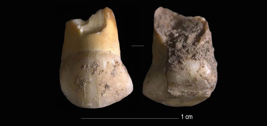
A 48,000 years old tooth that belonged to one of the last Neanderthals in Northern Italy
A milk tooth belonging to one of Italy’s last Neanderthal children has been found near Venice. The canine tooth belonged to a pre-teen, likely 11 or 12 years old, and dates back 45,000 years.
Neanderthals went extinct around 40,000 years ago after being out-competed for food and shelter by the more intelligent Homo sapiens. The tooth would have been in the upper row of teeth on the right-hand side of the child’s mouth.
It was discovered in a rock shelter at an archaeological site called ‘Riparo del Broion’ on the Berici Hills in the Veneto region, near Venice. The tooth is the first-ever human remain to be found at the site.
Genetic analysis of mitochondrial DNA preserved inside the tooth, as well as analysis of the enamel and shape, reveal it is from a Neanderthal and not a Homo sapien.
Matteo Romandini, lead author of the study at the University of Bologna says: ‘High-resolution prehistoric field-archaeology allowed us to find the tooth, then we employed virtual approaches to the analyses of its shape, genome, taphonomy and of its radiometric profile.
An upper canine milk-tooth (pictured) that belonged to a Neanderthal child, aged 11 or 12, that lived between 48,000 and 45,000 years ago was found in Northern Italy
Neanderthals (pictured, artist’s impression) went extinct around 40,000 years ago after millennia of struggling to compete with the superior intelligence of Homo sapiens which had recently arrived in Europe.
‘Following this process, we could identify this tooth as belonging to a child that was one of the last Neanderthals in Italy.’
Mitochondrial DNA is similar to normal DNA, except it is smaller and stored in the mitochondria, the powerhouses of human cells, not the nucleus.
The milk tooth was discovered in a rock shelter at an archaeological site called ‘Riparo del Broion’ on the Berici Hills in the Veneto region, near Venice. The tooth is the first-ever human remain to be found at the site
It is also inherited only from the mother and therefore paints a picture of maternal heredity. The owner of this tooth had a mother who was descended from Neanderthals that had lived in Belgium, the DNA revealed.
‘This small tooth is extremely important’, says Stefano Benazzi, professor at the University of Bologna and research coordinator.
‘This is even more relevant if we consider that, when this child who lived in Veneto lost their tooth, Homo Sapiens communities were already present a thousand kilometers away in Bulgaria’.
The early findings are published in the Journal of Human Evolution and researchers are still delving through the other findings the archaeological site has revealed.
For example, there are many signs of hunting and that the site was used to butcher large animals.
‘The manufacturing of tools, mainly made of flint, shows Neanderthals’ great adaptability and their systematic and specialized exploitation of the raw materials available in this area’, adds Marco Peresanti, a professor of the University of Ferrara who contributed to the study.
Neanderthals first arrived in Europe around 350,000 years ago and lived without rivals until around 45,000 years ago, when Homo sapiens first ventured into Eurasia.
When Homo sapiens — modern humans — moved into Europe they hunted the same animals and sought the same plants to survive a Neanderthals.
This proximity led to mingling and even interbreeding, Neanderthal DNA can be found in modern-day humans to this day.
It is believed the two species managed to co-exist for around 8,000 years, but the competition over limited resources led Neanderthals to extinction at some point between 43 to 38 thousand years ago.
A map showing the relative dates at which humans arrived in different Continents, including Europe 45,000 years ago. Humans and Neanderthals co-existed for about 8,000 years before Neanderthals went extinct
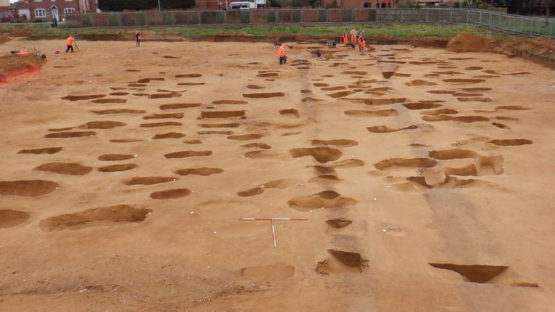
Anglo-Saxon Cemetery Excavated in the East of England
BBC News reports that an Anglo-Saxon cemetery that may date to the sixth century A.D has been found at a site slated for residential development in the East of England, within the border of the Kingdom of the East Angles.
The Anglo-Saxon cemetery is believed to date back to the same period as the famous Sutton Hoo burial site near Woodbridge
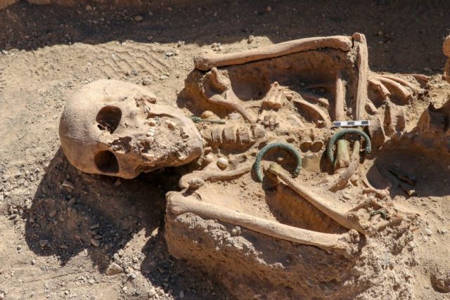
Brooches, pottery, small iron knives, wrist clasps, amber and glass beads, and silver pennies were uncovered among the more than 200 burials.
The grave included the bones of men , women and children and objects including brooches, small iron knives and silver pennies. Suffolk’s Archaeological Service said studies would help establish the graveyard’s links to other local sites
A spokesman said the site “lies within the Kingdom of the East Angles, made famous by the royal burial ground at nearby Sutton Hoo”.
Sutton Hoo, discovered in 1939, included two cemeteries from the 6th to 7th centuries and a ship burial full of treasures believed to be the final resting place of King Raedwald.
Artefacts which also include wrist clasps, strings of amber and glass beads, should eventually be available for public display.
Many of the skeletons are only visible as “sand-silhouettes”, a delicate form of preservation.
The site appears to contain several generations of a small farming community and the county council’s archaeological service said the excavation of such cemeteries in their entirety was rare in England, which made it “nationally significant”.
“It is important we oversee and record this work so that we can understand the community buried here and its connections to other finds in Oulton and the nearby settlements and cemeteries at Carlton Colville and Flixton,” said the spokesman.
Artefacts including copper-alloy brooches, wrist clasps, strings of amber and glass beads, small iron knives and silver pennies were discovered
Andrew Peachey, of Archaeological Solutions Ltd, which carried out the excavations, said the remains of 17 cremations and 191 burials were “painstakingly excavated”.
“Due to the highly acidic soil the skeletons had mostly vanished and were luckily preserved as fragile shapes and shadows in the sand,” he said.
Mr Peachey added many of the artefacts were so fragile they had “to be block-lifted for micro-excavation in the labs at Norfolk Museum Service”.
Remains found at the site had to be “painstakingly excavated” and fragments of wooden coffins were found
The remains have now been fully excavated ahead of the Persimmon Homes Anglia housing development.
They will undergo specialist analysis and eventually go on public display.
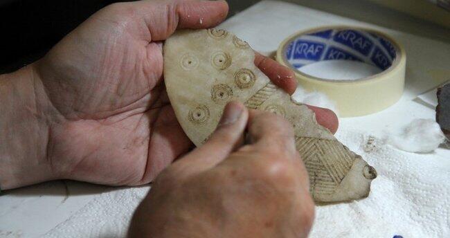
4,300-Year-Old Figurines Unearthed in Central Anatolia
Hurriyet Daily News reports that a team of researchers led by Fikri Kulakoğlu of Ankara University uncovered more than a dozen 4,300-year-old figurines thought to depict gods and goddesses at the Kültepe mound in central Anatolia. Previous excavation at the site uncovered 35 similar figurines in one room of the same building.
Due to its ashy soil that is some 25 kilometres from the city centre of Kayseri and has continued ever since excavations began 72 years ago in the region called “Kültepe.”
This year, statues of God and Goddess from 4,300 years of age, assumed by Anatolians, were found during the excavations. The figurines will be on display in the temporary exhibition at the Kayseri Museum.
Archaeologists work at the Kültepe archaeological site, Kayseri, central Turkey, Sept. 14, 2020.
Some of the statuettes found recently at the Kültepe archaeological site, Kayseri, central Turkey, Sept. 10, 2020.
Ankara University Faculty of Language and History-Geography member and the head of Kültepe excavations, Professor Fikri Kulakoğlu, told the state-run Anadolu Agency that one of the two tablets taken out of Kültepe in the late 1800s and sold to an antique shop in Istanbul had gone to the British Museum and the other to the Louvre Museum.
Stating that scientists, who were curious about the city mentioned in the tablets, came to Turkey but could not find any tablets, Kulakoğlu said: “There was a Czech scientist named Bedrich Hrozny.
This scientist is the first person in the world to solve the Hittite language. This person came to Kültepe in Kayseri to find out where the city of Kaniş mentioned on the tablets is.
He destroyed one-third of the palace that we call ‘Warşama Palace.’ He dug a hole like a crater according to the excavation techniques of that time.”
“He was disappointed that he could not find a tablet. He drew the attention of his coachman, who asked, ‘What happened to my master?’ He answered that he could not find a tablet.
The coachman said, ‘You dug the wrong place, the tablets are not there, but in Mehmet Ağa’s field.’ He went back and started excavations in the place we call Karum, but he could not find many tablets,” he added.
“Meanwhile, there was an epidemic of malaria in the region. Hrozny, who was a former soldier, brought a quinine tablet against malaria with him. People came to him because of the epidemic, they wanted medicine.
He gave them a quinine tablet in return for a cuneiform tablet. Thus, he collected tablets from the villagers. Thanks to the tablets that he collected, which proved that Kültepe was the city of ‘Kaniş’ mentioned in the first tablets.
He took the tablets to his country and returned them to Turkey in 1936. The tablets in the Istanbul Archeology Museum are the ones he studied and returned later,” the professor said.
Kulakoğlu stated that they have been looking for an answer to the question, “What was Anatolia like in the Ancient Bronze Age, the period before the Assyrian merchants came to Anatolia?” since 2009, and said that they have continued excavations in the area of Kaniş, which is called the “upper city.”
Reminding that they found 35 god and goddess figurines collectively in the excavations carried out in the room of a building in 2017, Kulakoğlu said: “We found 15 more idols [statuettes] this year. Excavations continue in this area.
The building we excavated is probably an official, religious, a very large and unique place in Anatolia. The idols extracted from here are the works that depict the beliefs of the Anatolian people and the beings they worshipped 4,500 years ago.”
“Some of them are sitting on the throne and some are made schematically. These are works that are not available anywhere but Kültepe. You find a work worshipped by a person 4,500 years ago and bring it to light; this is exciting.”
He added that they were planning to exhibit them at the Kayseri Museum with a temporary exhibition.
Urartian noblewoman buried with the jewelry found in the 2,750-year-old necropolis of Çavuştepe castle
Greek archaeologists have discovered a virtually intact grave of an ancient noblewoman buried with her golden jewellery at a Roman burial monument on the island of Sikinos.
Her name, according to a burial inscription, was Neko – or using the Greek alphabet.
The box-shaped grave was found untouched in the vault of the Episkopi monument, a rare burial memorial of the Roman era, which was later turned into a Byzantine church and a monastery.
Greek archaeologists have discovered a virtually intact grave of an ancient noblewoman buried with her golden jewellery at a Roman burial monument on the island of Sikinos. Her name, according to a burial inscription, was Neko
Golden wristbands, rings, a long golden necklace, a female figure carved cameo buckle, glass, and metal vases, and fragments of the dead woman’s clothes were found in the grave.
The well-preserved mausoleum on the tiny island, in the Cycladic group southeast of Athens, was likely to have been constructed to shelter the grave, archaeologists said.
‘We were unexpectedly lucky,’ Director of the Ephorate of Antiquities of Cyclades Dimitris Athanassoulis told Reuters on Monday. ‘This is Neko’s mausoleum.’
‘It’s very rare. A monument, one of the Aegean’s most impressive, has got an identity.
The box-shaped grave was found untouched in the vault of the Episkopi monument, a rare burial memorial of the Roman era, which was later turned into a Byzantine church and a monastery
‘We now have the person for whom the building was built, we have her remains, her name.’
Despite attacks by grave robbers in ancient times and the building’s various uses through the centuries, Neko’s grave was found intact mainly because it was well hidden in a blind spot between two walls in the basement of the building, Athanassoulis said.
He said that experts thought Neko had links to the island but it was not clear whether she was actually from Sikinos.
‘We are now trying to find out more about her,’ he said. ‘We are still at the beginning.’
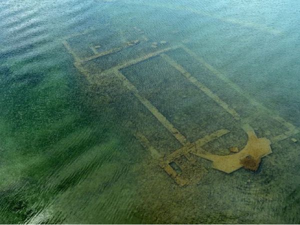
A 1,600-year-old basilica re-emerged due to the withdrawal of waters from lake iznik
The 1600-year-old basilica found under Lake Iznik in crystal clear water shows breathtaking aerial images. Archeologists, and art historians believe that after an earthquake in 740, the religious structure collapsed during an earthquake in 740, before sinking further into the lake.
The underwater building lies between 1.5 and 2 meters below the sea and can be clearly seen for the first time, as the coronavirus lockdown has resulted in less water pollution.
The local authority recently flew a drone over the site to take stunning images, revealing the basilica’s walls and structure just below the lake surface.
In 2014, when it was first found by experts, the Archaeological Institute of America named the basilica as one of the top 10 discoveries of the year. It was discovered while photographing the area from the air for an inventory of historic sites and cultural artifacts.
Five years ago the Doğan News Agency reported that the submerged structure was set to become an underwater museum. Experts believe it was built in AD 390, to honor St. Neophytos, who was among the saints and devout Christians martyred during the time of Roman emperors Diocletian and Galerius.
Neophytos was killed by Roman soldiers in A.D. 303, a decade before an official proclamation permanently established religious toleration for Christianity within the Roman Empire, they say.
I thought to myself, ‘How did nobody notice these ruins before?’ said Prof Mustafa Sahin
Uludag University Head of Archaeology Department Prof Mustafa Sahin told the agency in 2015 the church was built in tribute to him, at the place that he was killed.
He said: “We think that the church was built in the 4th century or a later date.
“It is interesting that we have engravings from the Middle Ages depicting this killing. We see Neophytos being killed on the lake coast.” Ancient resources show that Christians definitely stopped by Iznik in the Middle Ages while making their pilgrimage to visit the church.
“Rumour has it that people in Iznik were asking for help from the body of Neophytos when they were in difficulty,” Sahin said.
The researcher told Live Science that he been carrying out field surveys in Iznik since 2006, and “I hadn’t discovered such a magnificent structure like that.
“When I first saw the images of the lake, I was quite surprised to see a church structure that clearly.”
He also told the Archaeological Institute of America: “I did not believe my eyes when I saw it under the helicopter.
“I thought to myself, ‘How did nobody notice these ruins before?’”
PAGAN TEMPLE?
And, there might be a pagan temple beneath the church, reports The Weather Channel. Researchers have uncovered fragments of an ancient lamp and early coins from the reign of the emperor Antoninus Pius – indicating a more historic structure buried under the church.
Early coins found at the submerged basilica
Sahin said he believed the basilica could have been built on top of a temple to Apollo. The information shows there is a connection with the Roman emperor Commodus – to a similar temple at Iznik, then known as Nicea, outside city walls.
“Could this temple have been underneath the basilica remains?” Sahin asked of the church, which is to be transformed into an underwater archaeological museum.
The early Byzantine-era basilica has architectural elements from the early period of Christianity and is situated 20 meters from the banks of Lake Iznik in the north-western Turkish province of Bursa.
Archaeological finds excavated since 2015 include the memorial stamp of the Scottish knights, who were believed to have been among the first foreign visitors to the basilica, reports Daily Sabah.
World-first Perfectly Preserved Ice age bear found in Russia
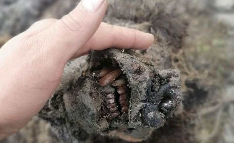
In the Russian Arctic, the fully preserved remains of an Ice Age cave bear were discovered – the first specimen of the animal that has ever been identified with soft tissues.
The remarkable discovery was found in the Lyakhovsky Islands in the Far North of Russia Part of the Modern Siberian Islands, find was made by reindeer herders
Previously only the bones of the cave bears had been found, but this specimen even had its nose intact, according to a team of scientists from the North-Eastern Federal University (NEFU) in Yakutsk, Siberia.
A head of an Ice Age cave bear found on Bolshoy Lyakhovsky Island, or Great Lyakhovsky, the largest of the Lyakhovsky Islands belonging to the New Siberian Islands archipelago between the Laptev Sea and the East Siberian Sea in northern Russia. Reindeer herders in a Russian Arctic archipelago have found an immaculately preserved carcass of an Ice Age cave bear revealed by the melting permafrost, which has all its internal organs, teeth, and even its nose intact.
The discovery is of “world importance,” a leading Russian expert on extinct Ice Age species said.
In a statement released by the university, scientist Lena Grigorieva said: “Today this is the first and only find of its kind — a whole bear carcass with soft tissues. It is completely preserved, with all internal organs in place including even its nose.
The Ice Age-era bear was found on the Lyakhovsky Islands in north-east Russia
“Previously, only skulls and bones were found. This find is of great importance for the whole world.”
The adult animal was found by a group of reindeer herders, who then transferred the right to research the specimen to the NEFU, which is at the forefront of research into extinct woolly mammoths and rhinos.
According to the team, the cave bear (Ursus spelaeus) is a prehistoric species or sub-species that lived in Eurasia in the Middle and Late Pleistocene period and became extinct some 15,000 years ago. Preliminary analysis suggests the bear is between 22,000 and 39,500 years old.
Maxim Cheprasov, the senior researcher from the Mammoth Museum laboratory in Yakutsk, said in the statement: “It is necessary to carry out radiocarbon analysis to determine the precise age of the bear.”
Scientists have not yet been able to visit the site of the discovery — the ancient carcass was found a long way from Yakutsk, which itself is more than 5,000 miles from Moscow.
Significant discoveries, including mammoths, woolly rhinos, Ice Age foal, several puppies, and cave lion cubs, have been made in Siberia in recent years as the permafrost melts.
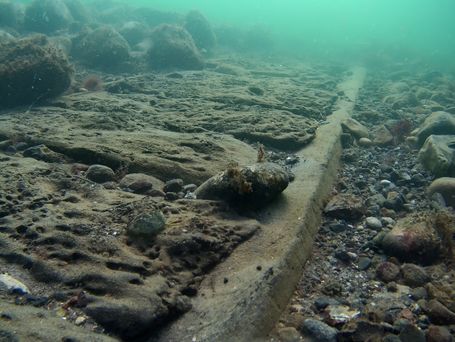
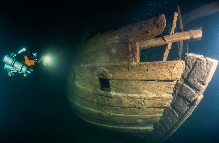
A well-preserved 400-year old ship has been found in the Baltic Sea
Although the company reported wrecks of some so-called 1st or 2nd World War wrecks at the mouth of the Gulf of Finland, Badewanne divers descended on one of the biggest surprises during their long career of diving the wrecks of this eastern extension of the Baltic Sea.
The Baltic Sea has been an exceedingly important trading itinerary since the Middle Ages, as the navies of Holland and England needed endless supplies of wood, tar, and hemp, all of which were available around the Baltic.
The Hanseatic League dominated the trade from the 13th century but the highly powerful merchant fleet of the Dutch Republic acquired dominance of the trade during the 17th century.
Port side hull view of the stern of the wreck. Decorated stern cabin window holes are visible.
This trade received a significant boost in importance and profitability after Czar Peter the Great founded his new capital St. Petersburg at the estuary of Neva river, in the easternmost part of GoF.
One ship type rises above others and becomes the mainstay of this trade: the Dutch “Fluit” ship, a three-masted ship with very capacious hull design, carrying no guns, and allowing a very large cargo capacity.
In addition, the Fluit ships utilized a very novel and advanced rigging using cleverly designed pulley and tackle systems for hoisting the yards and sails and controlling them.
These advanced technical features facilitated a much smaller crew than earlier ship types, making the trade more profitable. Another totally novel feature onboard the Fluit ships were that the entire crew lived “abaft of the mainmast” – Master, mates, bosun, cook, and all ratings, all occupied the same space ‘tween decks and ate at the same table.
This was very unusual in contemporary society, let alone in the highly hierarchic maritime world. Fluit ships were dominant in the Baltic trade between the late 16th to the mid-18th centuries. However, very few of these once common ships have survived, even as wrecks.
Therefore, it was to our great surprise when descending on a wreck at 85 meters depth, expecting to see an early WW1 minesweeper or a schooner sunk during WW2, we realized that we are looking at an almost completely preserved Dutch Fluit ship! She rests on even keel on the seabed, with most of her rigging scattered around her.
There is only slight damage from a pelagic trawl. The trawl seems to have swept her from a bow towards the aft, dislocating the stem, damaging the poop deck, and the topmost part of the typical Fluit transom somewhat.
Apart from these damages, the wreck is intact, holds are full, and all side planking is firmly in place. Even the damaged parts and components of the transom decorations, such as the “Hoekmen”, or the “Strongmen” may be found on the bottom behind the stern. Luckily, only very small bits of the trawl netting remain on the wreck.
Anchor windlass in the bow, viewed from the starboard side.
It is only in rare places around the world, including the Baltic Sea, where wooden wrecks can survive for centuries without being destroyed by chemical, biochemical and biological decaying processes.
Due to low salinity, absolute darkness, and very low temperatures all year round these processes are very slow in the Baltic. Perhaps most importantly, wood-boring organisms such as shipworm cannot live in such an environment. Even in temperate seas, all wooden wrecks vanish in decades, unless buried in sediments.
This find, a practically intact and complete Dutch Fluit ship, the Queen of the Baltic trade from almost 400 years back, is a good example of the importance of the Baltic Sea, and especially the Gulf of Finland as a special cellar of the sea.
Only here the environment preserves the wrecks, which are plentiful due to the sea being a very important trade route and battleground for many wars during centuries.
And all of these wrecks are within the range of modern technical diving methods! Badewanne team will continue documenting and investigating this significant wreck in co-operation with the Finnish Heritage Agency of Antiquities and other partners, Including Associate Professor Dr. Niklas Eriksson, Maritime Archaeologist, Univ. of Stockholm, Sweden:
“The wreck reveals many of the characteristics of the fluit but also some unique features, not least the construction of the stern. It might be that this is an early example of the design. The wreck thus offers a unique opportunity to investigate the development of a ship type that sailed all over the world and became the tool that laid the foundation for early modern globalization,” says Dr. Eriksson.