Medieval “plague” mass grave discovered in north Dublin
According to an Irish Central report, walkers in North County Dublin spotted bones eroding out of the surface of the ground during a period of drought this spring.
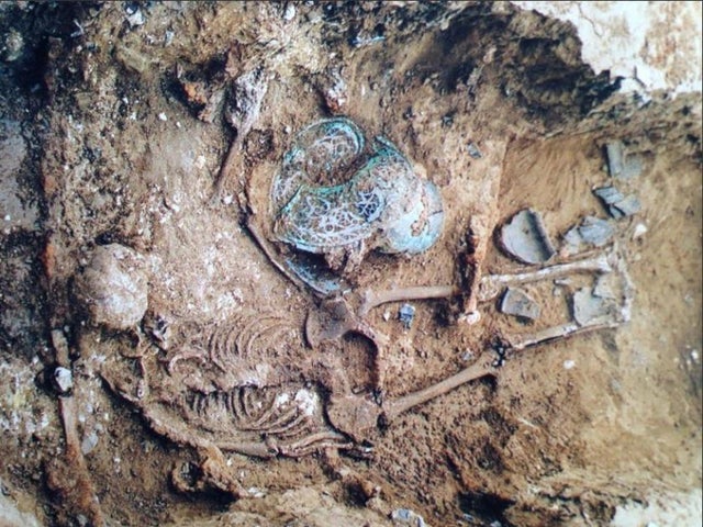
Examination of the bones by osteoarchaeologist Maeve McCormick revealed they belonged to a boy who was about 12 years of age at the time of his death.
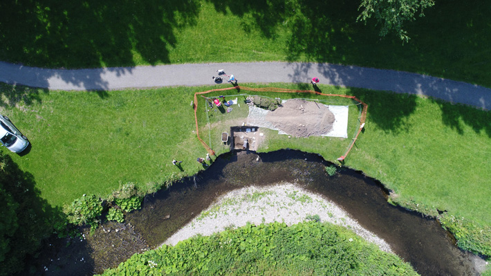
The 12-year – old skeletal remains were found in River Valley Park, Swords, North County Dublin in April 2020. The bones that have now been extracted from the test area date back to the 15th century.
The skeletal remains of a 12-year-old, found in Swords, earlier this year are believed to be part of a plague burial ground.
Experts at the National Museum of Ireland said the bones became exposed due to the unseasonably dry weather in March and April.
Sadly, due to COVID-19 restrictions, the site could not be excavated. However, Fingal County Council told the Irish Times that with the easing of restrictions the examination has begun.
The site where the remains were found by walkers is a recorded archaeological monument, where archaeologists from the National Monuments Service excavated six skeletons in 1999.
They said the bones “were medieval in date and as the burials were deposited in an irregular fashion within a flood plain it was thought they may reflect some form of communal hasty burial of victims of plague or other trauma.”
The excavation was undertaken by Maeve McCormick, of Archer Heritage Planning Ltd, under license from the Department of Culture, Heritage and the Gaeltacht in consultation with the National Museum.
McCormick, an osteoarchaeologist, indicated that the latest skeleton unearthed was a juvenile, probably between ten and 12 years of age and that these remains are part of a burial site excavated in the area, in 1999.
Radiocarbon dating of the animal and human remains will allow them to get a precise timeline for the site.
Fingal County Council’s Heritage Officer Christine Baker says this analysis will “add to the story of this burial ground”.
“We are also investigating the most appropriate means to suspend the erosion of the site and will continue to work with the National Monuments Service and the National Museum of Ireland to protect this archaeological monument,” she said.
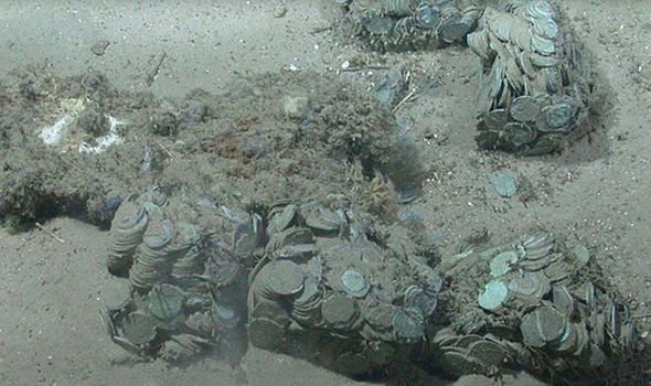
A hidden hoard of more than 6,000 silver coins found in a forest in Poland
This year a forest ranger in eastern central Poland came up with a lifetime discovery — he had found a treasure hidden in a wooded area near the village of Guzów, which included thousands of silver coins.
A hidden hoard of more than 6,000 silver coins found in a forest in Poland
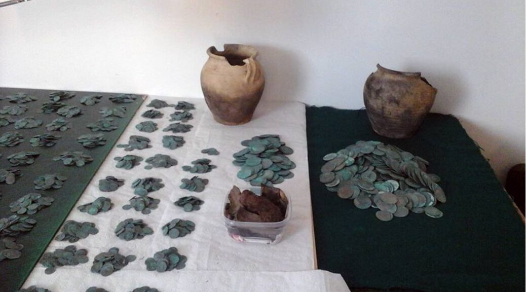
Forest worker Bogusław Szwichtenberg spotted two clay pots along the wooded road in April this year. A cache of more than 6,000 silver coins was discovered as he opened them. He turned the find over to the Archaeological Museum of the Middle Oder in Zielona Góra, where conservation experts are now attempting to restore the coins, reports the museum’s Facebook page.
According to Polish news site Science & Scholarship in Poland (PAP), the silver coins have been provisionally dated to the sixteenth and seventeenth centuries. They were recovered in fairly good condition but were tarnished and stuck together in lumps.
The tarnished coins found in clay jars by a forester in Poland.
Barbara Bielinis-Kopeć, the Lubuskie Provincial Conservator of Monuments and specialists in the field of archaeological preservation has pointed out that not all of the coins have yet been cleaned, so dating could change. So far, the oldest coin was minted in 1516, and the newest in 1612.
In total there were 5,370 smaller coins (denarii), and 787 larger ones (Prague groschen).
“For now, they are easily separated, but only at the end of the conservation work we will see if we can separate all of them without damage,” Bielinis-Kopeć told PAP.
Silver coins found in a forest in Poland, as cleaned by archaeological restorers.
The area where the coins were found has been marked as an archaeological study location. The site was hidden by the side of an old road that connected two small towns.
By all measures, the silver coins are an excellent find, and yet other remarkable coin hoards have been discovered in Poland, including what is known as the “Treasure of Głogów”. One of the largest treasure finds in Poland, the famous medieval cache was uncovered in 1987 by locals.
Archaeologists finally counted more than 20,000 silver coins in all, as well as thousands of coin fragments, and seven bars of silver.
The coins dated back to the 11th and 12th centuries. They were thought to have been owned by a wealthy cleric or knight, as Głogów was a vital center for the church and state at the time.
It has been a busy year for archaeology in Poland as researchers have located an 18th-century sex toy in latrines in Gdańsk, a Scythian treasure site at a ceremonial spring, and a huge Roman-era burial site including ‘princely graves’.
Bielinis-Kopeć said of the recent coin find, “This is the greatest discovery of this kind made in today’s province Lubuskie.”
More details are expected to be announced by officials as the coins are restored. The silver treasure is a lucky find that adds to the picture of the early modern era Poland.
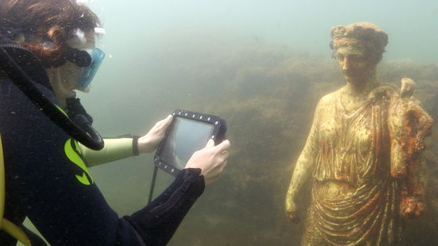
The underwater statues at Baiae are replicas but still feel “ghostly and sublime”. “You’re sure I can cross?” I had to almost shout to be heard. Wooden slats dotted the ground before me.
About 30m to my right, steam rose into the sky in thick grey-white clouds. And somewhere between where I stood now, and there, the earth turned from solid and cool to boiling and viscous. Wherever that exact change happened, I wanted to make sure I was none too close. It’s very dangerous here “ Sì, sì, ” said volcanologist Enzo Morra, my guide for the day. He was already climbing the hill on the other side of the wooden slats before me.
I edged one foot onto one piece of wood, then the next. The ground felt firm. As I reached the far side and climbed the hilltop, I could see the source of the steam: a bubbling pool of dull gunmetal-grey mud, ominous as the contents of a witch’s cauldron and a great deal louder. The air smelled of sulphur.
“It’s very dangerous here,” Morra welcomed me when I arrived. “More dangerous than Vesuvius.” Campi Flegrei is one of 20 known “supervolcanos” on the planet I laughed nervously. “I wish you’d told me that when we were over there. Why are you telling me that when we’re here ?”
We were overlooking one of the fumaroles of Campi Flegrei, known in English as the Phlegraean Fields. One of 20 known “supervolcanoes” on the planet – capable of erupting with a volume thousands of times stronger than an average volcano – Campi Flegrei commands less notoriety than Mt Vesuvius, just 30km to the west.
But that is largely down to luck. If Campi Flegrei were to blow at maximum capacity today, it would make the 79AD eruption of Mt Vesuvius that destroyed Pompeii look like a puppy’s sneeze. Fortunately, Campi Flegrei hasn’t had a full-force eruption in thousands of years.
That isn’t to say it’s impossible. Researchers call the supervolcano “restless”, and there are concerns it is becoming more so. In 2012, the alert level was raised from green to yellow, indicating a need for more monitoring. Most recently, a “seismic swarm” in April 2020 saw 34 different earthquakes.
Campi Flegrei is more than a (fitfully) snoozing menace. It’s why the ancient Romans built one of the most magnificent resort towns on the Italian peninsula here: Baiae, famed for its hot springs and bad behavior.
It’s also why at least half of the town, with its precious marbles, mosaics, and sculptures, sank beneath the Mediterranean over the following centuries. Now, this “restless” supervolcano is the reason why much of this archaeological site is at risk today – both indirectly, thanks to the sea’s effect on the artifacts, and directly, in terms of the threat of earthquakes or another volcanic eruption.
The underwater statues at Baiae are replicas but still feel “ghostly and sublime”
The Romans had few ways of knowing when an eruption or earthquake was coming. They were all but helpless when it came to protecting their town against the encroaching sea. But that’s no longer true. Today, a team of archaeologists and engineers are developing some surprising new technologies to protect the underwater site for future generations. And that’s what I’ve come here to learn more about. Lured by the volcano’s hot springs, the Romans built the magnificent resort town of Baiae here (Credit: Amanda Ruggeri) Over its full 13km radius, the supervolcano, almost all of it at ground level or beneath the sea, has 24 craters and more than 150 pools of boiling mud. It’s easy to see how the ancient Greeks, who settled here first, came up with the name: “Phlegraean Fields” is from the early Greek verb phlégō (“to burn”).
This underwater mosaic was once part of a floor of a magnificent villa
The danger of Campi Flegrei isn’t just its size and strength, but its randomness. When a volcano-like Vesuvius erupts, you know where the eruption will come from the cone at its peak. Not here.
“The activity isn’t ever in the same place. Every eruption has its own story and place of emission,” Morra said. “Therefore, we obviously don’t know when the eruption will happen. But we also don’t know where the next eruption will happen, if there is one.”
Another danger is the type of activity: more than 90% of the activity Campi Flegrei is explosive, not effusive. In other words, when it blows, it won’t leak lava over the ground; it will punch a column of rock and lava into the air. When the detritus lands, the ash will blacken the sky and thicken the air, making both seeing and breathing near-impossible. The column’s collapse causes a pyroclastic flow: extreme heat of up to 700C that vaporises everything in its path.
That, at least, is what happened 39,000 years ago, the date of Campi Flegrei’s largest eruption. Molten rock spewed 70km high. Ashes were found as far away as Siberia. The explosion was so powerful, the volcano collapsed into a caldera. The cooling that occurred in the ensuing years may even have helped bring about the end of the Neanderthals.
Volcanic vents made the water warm — and look almost oily
Fifteen thousand years ago, Campi Flegrei erupted again. The eruption wasn’t as large, but it threw significant volumes of yellow tufa into the air – enough to give Naples its colour today. People carved through and built with the local stone, giving the palazzi, churches, and even underground tunnels their golden colour. The last significant eruption was in 1538. Compared to these previous two events, it was tiny. It was also big enough to throw ash and pumice 5.5km high. As the column collapsed, it created a “new mountain” (dubbed, quite literally, Monte Nuovo), measuring 123m high – and burying a village beneath it. If this happened today, in the vicinity of Italy’s third-most-populous city, Naples, the damage would be severe.
So what is the possibility of such an eruption happening in our lifetimes?
“Obviously we can’t make estimates,” Morra said, almost languidly. “We know that an active volcano, an active volcano, can erupt. Clearly, in our heart – we hope not.” I looked worried. “Have courage!” he said. “Like Vesuvius, Campi Flegrei is continuously monitored by colleagues at the Vesuvian Observatory, the oldest volcano observatory in the world. This can make us feel more tranquil.”
Close monitoring means an eruption can be predicted months in advance. With enough warning, the hope is that the metropolitan area can be safely evacuated.
Signs of a pending eruption aren’t the only data that volcanologists collect. The Vesuvian Observatory was also the first to discover, and chart, a phenomenon known as “bradyseism”: the slow rising, and sinking, of land over time. As the magma in Campi Flegrei’s massive magma chamber moves 3km below ground, so does the land above – sometimes significantly. Over the last 15,000 years, the movement of the magma has pushed the land above it upward by some 90m. At the same time, other parts of the caldera have fallen.
Researchers left ‘speechless’ by ‘magical’ Iron Age treasure
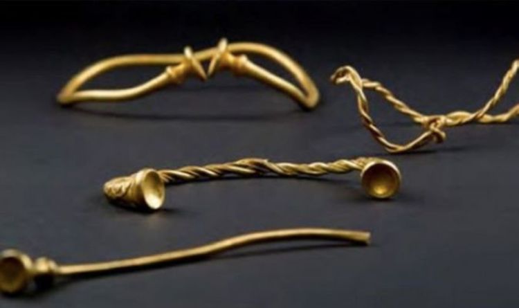
Archaeologists were stunned when they unearthed Iron Age treasure owned by extremely wealthy figures from the time period. The amazing discovery was made in 2016 as two treasure hunters – Mark Hambleton and Joe Kania – found the earliest example of Iron Age gold ever found in Britain.
The collection included four twisted metal neckbands, called torcs and a bracelet. Experts concluded the jewellery would have been owned by wealthy powerful women who probably moved from continental Europe to marry rich Iron Age chiefs.
Mr. Hambleton was also delighted when he and his partner were told the find could be worth hundreds of thousands of pounds. Mr. Hambleton said at the time: “We weren’t expecting to find anything. I was just about ready to give up for the day when Joe said he thought he had found something.
The jewellery was worth over £300,000
“We both looked at it and were speechless.”
Mr. Kania added: “We have found the odd Victorian coin, but mostly it has just been junk.
“So I couldn’t believe it when I picked out this mud-covered item and on cleaning it off, I thought this might actually be gold.”
Mr. Hambleton also told of how he slept with the jewellery before taking it to the Portable Antiquities Scheme at Birmingham.
He added: “I kept the gold right next to my bed to make sure it was safe until we could hand them into the experts.
“I used to go metal detecting with my dad when I was young and he said to me ‘why are you bothering fishing? You should be back in those fields.’
“I am so glad we took his advice and pleased, of course, that he got the chance to see these amazing pieces and prove he was right all along.”
Dr. Julia Farley, Curator of British & European Iron Age Collections for the British Museum lauded the find.
She said: “This unique find is of international importance.
“It dates to around 400–250 BC and is probably the earliest Iron Age gold work ever discovered in Britain.
“The torcs were probably worn by wealthy and powerful women, perhaps people from the continent who had married into the local community.
David Booth, metal detector enthusiast poses with his hoard of Iron Age Gold
The torcs were buried nested together and archaeologists believe they may have been buried for safekeeping. Others claimed they could have been buried as an offering to a God, or even as an act of remembrance for someone who had died.
The find was made about 45 miles north of Hammerwich, near Lichfield – the site of the 2009 Anglo-Saxon Staffordshire Hoard find, which was officially valued at £3.2 million.
Researchers stunned by ‘perfect’ £300million shipwreck treasure
The fortune of the Nuestra Senora de las Mercedes, which sunk in a fight near Portugal’s Cape St Marie in 1804, was raised in an American court after a US salvage company took 594,000 gold and silver coins worth £308 million from the site in 2007.
The curator of Spain’s National Museum of Underwater Archeology, Mr. Ivan Negueruela, said: “The finds are of inestimable scientific and historic value.”
It is believed that the ship was shot down before Spain joined the Napoleonic Wars against Britain. When the Amiens Peace of 1802 broke down, Britain declared war on France in an uneasy peace with Spain.
In 2007 some of the cargo was retrieved by the Odyssey Marine Exploration company, which had it flown to Tampa, Florida. A court in 2012, however, forced the treasure hunters to return the haul to Spain.
The items found had been listed in the ship’s manifest, including cutlery inscribed with a passenger’s name. An archaeological report said: “Mention should be made of the perfection with which the documentary sources coincide with archaeological evidence in this case.”
Elisa de Cabo, the Spanish Culture Ministry’s deputy director of national heritage said in 2012 the find was “invaluable”.
She added: “How would you put a price on the Mona Lisa?”
The treasure was worth £300million
The vessel was downed in battle
A similar find could be made this year as researchers from both Spain and Mexico hope to unearth a historic Spanish galleon that fell to the bottom of the Gulf of Mexico in October 1631.
The ship is called the Nuestra Senora del Juncal (Our Lady of Juncal) and sank to the depths while carrying gold, silver, and jewels that could be worth billions today. The vessel and its sailors were hit by vicious storms as they made their way to Spain, and even before the challenging weather, the crew was stripped of its commander due to illness.
With the ship slowly becoming flooded with water, and repair desperately needed, the Nuestra Senora del Juncal plugged away through two weeks of relentless storms.
Coins rescued from the Frigate Mercedes
Dr. Iván Negueruela, the director of Spain’s National Museum of Underwater Archaeology, has claimed the chances of locating and finding the ship are looking good.
He said: “Because the cargo was so valuable – it was carrying lots of ingots – the authorities had a detailed inventory.
“The survivors were also questioned in-depth and their statements help us to reconstruct what happened with quite a high degree of accuracy, so we have a fairly good idea of where the ship sank.”
Posh grave of Iron Age ‘warrior’ buried 2,000 years ago in Roman Britain uncovered
UCL archaeologists have uncovered a richly furnished grave belonging to an Iron Age ‘ warrior ‘ found 2,000 years ago in West Sussex.
Iron Age warrior grave excavated in West Sussex
In the grave were placed iron weapons, including a sword in a highly decorated scabbard and a spear. The burial was discovered during an excavation commissioned by Linden Homes, who are developing a site on the outskirts of Walberton, near Chichester, to create 175 new homes.
The team that made the discovery were from Archaeology South-East (ASE), the commercial branch of UCL’s Institute of Archaeology.
ASE archaeologist Jim Stevenson, who is managing the post-excavation investigations into the burial, said: “There has been much discussion generally as to who the people buried in the ‘warrior’ tradition may have been in life.
Were they really warriors, or just buried with the trappings of one?
Sword midway through conservation and its X-rays
“Although the soil conditions destroyed the skeleton, the items discovered within the grave suggest that the occupant had been an important individual.”
The grave is dated to the late Iron Age/ early Roman period (1st century BC – AD 50). It is incredibly rare, as only a handful are known to exist in the South of England.
X-rays and initial conservation of the sword and scabbard reveal beautiful copper-alloy decoration at the scabbard mouth, which would have been highly visible when the sword was worn in life.
Dotted lines on the X-ray may be the remains of a studded garment worn by the occupant when buried. This is particularly exciting for archaeologists as evidence of clothing rarely survives.
Ceramic jar found in the grave
The grave also held the remains of a wooden container, preserved as a dark stain, likely used to lower the individual into the grave.
Four ceramic vessels were placed outside of this container, but still within the grave. The vessels are jars made from local clays and would usually have been used for food preparation, cooking and storage.
It is likely that they were placed in the grave as containers for funerary offerings, perhaps intended to provide sustenance for the deceased in the afterlife.
Archaeologists are continuing to investigate this new discovery. By looking at other burials with weapons from the same time, they hope to find out more about the identity and social status of this individual, and the local area and landscape around that time.
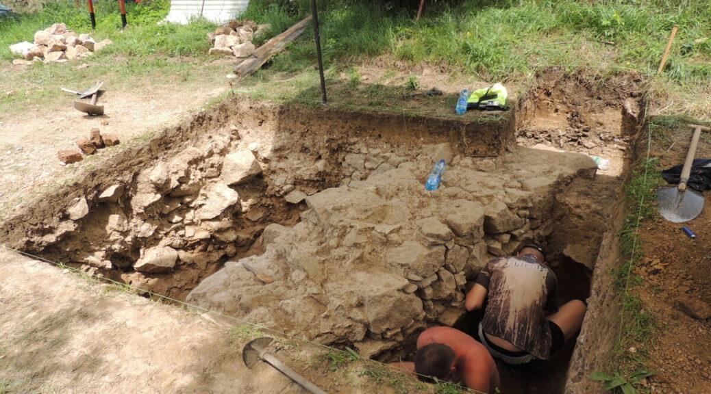
Site of 18th-Century Steam Engine Uncovered in Slovakia
In recent day’s Nová Baňa, approximately 40 volunteers have worked under the expert supervision of archeologists to unleash a special Potter atmospheric steam engine, the first one of its kind on the continent of Europe.
In the Althandel shaft, the atmospheric steam engine was built and was used in the 18th century. Enthusiasts from the mining group Novobanský had decided a while ago to reveal this treasure to the public, hidden in the garden of one house.
Matej Styk, an expert assistant from the Department of Archaeology of the Constantine the Philosopher University in Nitra, said that two-week research followed last year’s findings of the archaeologists. Its aim was to research the discovered construction and the discovered features, proving mining activity in the 18th century.
“In two weeks, we succeeded in uncovering the entire measurement of the Potter engine room, about eight and 14 meters,” he said, as quoted by the TASR newswire. He added that the masonry is compact, undamaged, located about 30 to 40 centimeters under the ground surface.
Bigger than anticipated
Thanks to research, they can prove that activities were ongoing not only in the 18th but also in the 19th century. In the interior of the engine room, the bases of another construction were found, about which there was no knowledge until now.
“There were many tiles from a stove inside,” Styk noted for TASR. “We think that the building was wooden. It has a stone foundation wall and inside another production activity was ongoing.”
Styk noted that the measures of the engine room itself were surprising. The building was bigger than they anticipated.
They succeeded in finding several interesting objects during the research, a mining button from probably the 19th century, a pipe or various iron nails, and components.
Mining failed
The steam engine served to drainage of water from mine. The head of the Slovak mining archive in Banská Štiavnica, Peter Konečný, said that it was built by Isaac Potter in the Althandel shaft in the years 1721-1722.
“Isaac Potter operated this machine alongside his colleagues within the mining industry, which received the right to mine local ores,” Konečný noted, as quoted by TASR.
However, mining was not successful, over in a few years and the machine put out of the operation, Konečný said. Potter remained for several years, but the state, which paid the construction, offered the opportunity to shift it to another private miner, to Hodruša.
“There we lost its traces because the supposed shift to Banská Štiavnica did not happen,” said Konečný for TASR, adding that this assumption is not proven.
The remains of the unique machine should be accessible to the public in the future. The association would like to build an open-air folk museum at the site. They succeeded in persuading the municipality in purchasing the house with the garden where the engine room was discovered.
Museum and replica planned
The head of the association, Zoltán Vén, said that the original owners did not have a clue as to the treasure in the ground. The association was behind the finding, which discovered it inaccessible documents.
Vén noted that they have big plans with the compound. They would like to build a replica of the machine and they have some ideas on how to use the house as well. It should be the headquarters of the mining association and a museum exhibition.
Vén said that last year, British Ambassador Andrew Garth, who is leaving Bratislava at the end of July, also visited the place.
“We would like to have contact with him to be able to go to the UK, as they have one museum piece working. We would like to see it,” Vén summed up, as quoted by TASR.
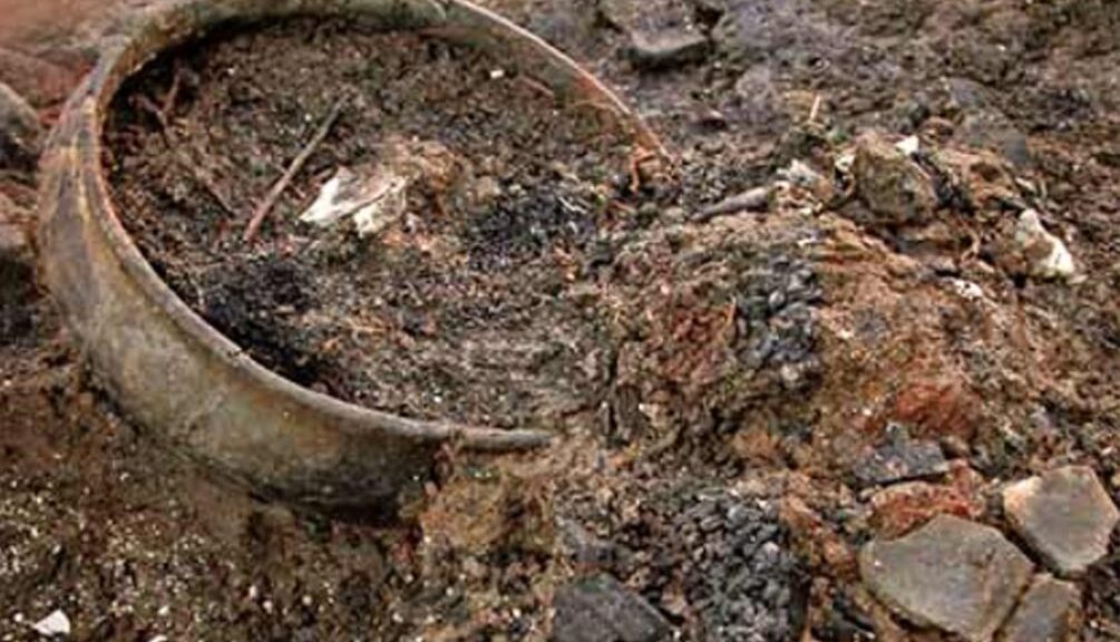
Bronze Age time capsule: 3,000-year-old vitrified food found in jars in England
The life of the prosperous people of Bronze Age Britain could be “extraordinary proof” that remains under the ground of a 1,100-square meter site destroyed by the fire 3,000 years ago. They suggest that archeologists are about to dig in a brick pit near Peterborough.
Archaeologists found food from between 800-1000 BC in a set of pots, textiles and other material at a Cambridgeshire settlement destroyed by fire during the Bronze Age
Must Farm – part of the Flag Fen Basin, and the site where nine pristine log boats were famously unearthed in 2011 – was protected by a ring of wooden posts before a dramatic fire at the end of the Bronze Age caused the dwelling to collapse into the river.
Its submergence preserved its contents, creating what experts are describing as a “time capsule” of “exceptional” decorated tiles made from lime tree bark.
An Early Iron Age logboat found in the palaeochannel
Rare small pots, jars complete with 1,200-year-old meals, and “sophisticated” exotic glass beads are expected to provide a complete picture of prehistoric life during the nine-month excavation, which is part of a four-year, £1.1 million project at the site.
“We think those living in the settlement were forced to leave everything behind when it caught on fire,” says Kasia Gdaniec, Cambridgeshire County Council’s Senior Archaeologist.
“An extraordinarily rich range of goods and objects are present in the river deposits, some of which were found during an evaluation in 2006.
A Late Iron Age baldric ring with La Tène style decoration, probably part of a shoulder belt for carrying a sword, found in the peat which formed in the Must Farm palaeochannel when then the watercourse became entirely choked by sediment at the end of the first millennium BC
“Among the items was a charred pot with vitrified food inside it and a partially charred spoon, suggesting that the site had been abandoned quickly.
“We anticipate that more of the timber structure, a range of organic remains and fishing equipment and the whole gamut of personal, work, and settlement paraphernalia will be found.
“But we are hoping not to find remains of people that may have suffered the impact of the fire, though this possibility cannot be ruled out.
“It’s an exciting excavation. The finds are well preserved due to the waterlogged sediments within this former river channel. The footprints of the settlement’s former residents still stand, although more discoveries are not expected to emerge until late summer.
The mass of preserved timbers was originally discovered during an excavation in 2006
“Usually at a Later Bronze Age period site you get pits, post-holes and maybe one or two really exciting metal finds,” says David Gibson, the Archaeological Manager at the Cambridge Archaeological Unit.
“Convincing people that such places were once thriving settlements takes some imagination. But this time so much more has been preserved.
“It’s a fantastic chance to find out how people in the Late Bronze Age lived their daily lives, including how they dressed and what meals they ate.”
The location of the site, at the edge of the quarry, meant attempts to preserve it in situ after it was discovered in 2006 proved unviable as a long-term historic record.
“The combination of sudden abandonment followed by exceptional preservation means that there is a real possibility of further exciting discoveries,” says Duncan Wilson, of Historic England.
“This could represent a moment of time from the Late Bronze Age comparable to the connection with the past made by the objects found with the Mary Rose.
“This site is internationally important and gives a fascinating insight into the lives of our ancestors.”
A rapier and sword were found at the clay quarry, now run by a building company, in 1969. The new discoveries will be displayed at the Peterborough Museum and other local venues.