Turkey: 3rd-century statue unearthed in the ancient city
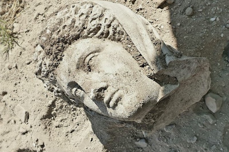
Archeologists have unearthed a 1,700-year-old statue of a female from the Hellenistic period in the ancient city of Perge, now in Turkey’s Mediterranean Antalya province.
ANTALYA, TURKEY—The Anadolu Agency reports that a third-century A.D. sculpture of a woman has been unearthed at the ancient Greek city of Perge on the southwest coast of modern-day Turkey.
A team led by Istanbul University archaeologist Sedef Cokay Kepce also discovered the broken head that belongs to the figure, which is depicted in full-length robes.
The statue of a female discovered on July 27 in Perge, Antalya, Turkey.
Believed to have been made around the year 300 AD, during the time of the Roman Empire, the exquisite piece of sculpture portrays a woman in floor-length robes. Her head has been broken off but it survives.
The ancient city was known to have had females in its administration. It is unknown, however, at this point, just who is depicted in the sculpture.
The Turkish Ministry of Culture and Tourism’s excavation department triumphantly announced the amazing find yesterday, stating “First sculpture of 2020 found in Perge excavations,” in a tweet.
According to the Ministry, Sedef Cokay Kepçe, an archaeology professor at Istanbul University, is heading up the excavations which unearthed the stunning find.
The plans are currently to display the third-century statue in the Antalya Museum when all the necessary cleaning on the piece has been completed. The area has always been known for its wealth of sculpture, according to UNESCO.
The ancient Greek city of Perge has been the site of systematic excavations beginning in 1946; the area was included on UNESCO’s Tentative Heritage list in 2009 for its great historical significance.
The Medieval Book That Emerged from a Bog After 1200 Years
The book that emerged from a bog after 1200 years
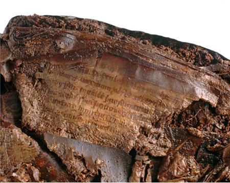
This is the remarkable story of a medieval book that spent 1200 years in the mud. Around 800 someones had a Book of Psalms made, a portable copy fitted with a leather satchel.
The book consisted of sixty sheets of parchment that were carefully filled with handwritten words. Somehow the book ended up in a remote bog at Faddan More in north Tipperary, close to the town of Birr, Ireland.
Dropped, perhaps, by the owner? Was he walking and reading at the same time? Did he himself also end up in the bog?
Fast-forward to 2006. Eddie Fogarty, the operator of a turf digger, noticed an object with faint lettering in the bucket of his machine.
Thanks to the conservation properties of turf, many pages of the book were still intact, as was its leather satchel the only surviving specimen from this early period.
Faddan More Psalter, c. 800: when it was found.
There it was again, our Book of Psalms! At this point, it resembled something from an Aliens movie (pic 2), but that changed quickly after it went to the restoration lab.
Faddan More Psalter, c. 800: before the start of restoration
Thanks to the conservation properties of turf, many pages were still intact, as was its leather satchel (pic 3), the only surviving specimen from this early period.
Faddan More Psalter, c. 800: restored cover
Remarkably, among the damaged pages were some that had let go of the words: kept together merely by ink, the words were floating around by themselves – like some sort of medieval Scrabble (pic 4). It’s the most remarkable bookish survival story I know.
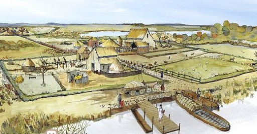
One of the discoveries of archeological work in Waterbeach Barracks was Roman pottery and coins, along with Bronze Age PalStave ax-head. Before work starts on the first phase of the new town development, Oxford Archaeology East has been working with developer Urban & Civic and Cambridgeshire County Council’s historic environment team at the site.
Comprehensive research was undertaken and three areas of Roman settlement, two areas of Roman industry and several parts of a medieval field system – called a ridge and a furrow – were uncovered
The land is at the junction of two important Roman regional transport links: the Car Dyke (Old Tillage) Roman canal which is one of the greatest engineering feats carried out by Romans in Britain – and the Roman road known as Akeman Street, which connects Ermine Street near Wimpole Hall and runs along the alignment of Mere Way joining the broad route of the A10 up to the north Norfolk coast.
Oxford Archaeology East working at the Waterbeach Barracks.
The archaeology team has been investigating the site since 2016, and following desk-based research and geographical surveys of the key areas, they have opened nearly 140 archaeological trial trenches across the entire site to explore what has survived the more recent agricultural and military uses.
Over the last few weeks, approximately seven hectares – the size of 10 football pitches – have been dug in the northern corner of the airfield, with early evaluation identifying a potential Roman settlement.
Having stripped the topsoil with excavators, the team was able to delve deeper with hand tools to explore and interpret the layers of history beneath. This included a complex system of ditches, dating to the latest Iron Age and early Roman period (about 2,000 years old) as well as a lot of artifacts: from Roman pottery and coins to an amazing Bronze Age palstave axe-head.
A number of pottery kilns were also found that would have produced pottery during the Roman period.
Oxford Archaeology East working at the Waterbeach Barracks.
Stephen Macaulay, deputy regional manager of Oxford Archaeology East, said: “Waterbeach Barracks is a fascinating site and the new development gives us a unique opportunity to capture the essence of its foundations and an understanding of how our ancestors lived and worked the land.
“The site is in a unique location and the historic role of Car Dyke and Akeman Street Roman road (the modern A10) and water connections need more celebration within Cambridgeshire. Hopefully, the approach at Waterbeach is the start of making that happen.”
Further archaeological excavations will take place in advance of each phase of development at Waterbeach. The first phase covers 1,600 homes, while 6,500 will be built in total on the site by Urban & Civic.
Rebecca Britton, of Urban & Civic, said: “Waterbeach Barracks is a historic place with rich layers of heritage that span millennia.
While the recent military past is something that we are all familiar with, this work enables us to dig deeper into the past, find out more about how our predecessors lived and what they did here.
“This is not only incredibly useful in informing our understanding of the past, but also provides a rich seam of inspiration for the future development: whether it’s street or park names, the design of public art, or part of connecting future residents with the history literally under their feet.
“History is a great way of establishing connections between people and is part of our wider commitment to working with Denny Abbey, the Tithe Barn at Landbeach, Wicken Fen, and other important local heritage assets to engage people with and celebrate the amazing history.”
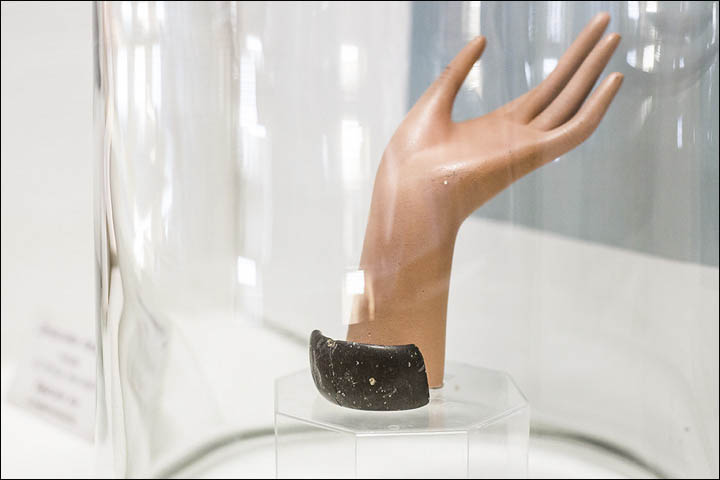
The 7,000-year-old stone bracelet is oldest ever found in the world
A Paleolithic man’s stone bracelet claimed to revolutionize our understanding of early human development. Scientific analysis suggests that the enchanting find is a 65,000 to 70,000 years old.
It’s the oldest piece of jewelry of its kind in the world that experts believe to be made by an extinct group of early people named Denisovan.
The community is closely related to Homo sapiens and Neanderthals, If confirmed, it would push back the date of its creation by around 30,000 years and show that technology used in its creation was available much earlier than thought.
While bracelets have been found pre-dating this discovery, Russian experts say this is the oldest known jewellery of its kind made of stone.
Scientists from the universities of Oxford and Wollongong in Australia are due to meet this month with Russian colleagues. The academics will analyze and interpret data from tests on the age of the soil layer in which the bracelet and other artifacts, including a pre-historic needle, were found.
At an exhibition in France this year the green-hued chlorite bracelet, unearthed in a Siberian cave, was listed as 50,000 years old. It was earlier reported as originating from 40,000 years ago and made for an ancient woman by a Paleolithic craftsman.
But Russian researchers have suggested the jewellery item comes from a time long before early man was believed to have the skills or know-how to make such objects. Maksim Kozlikin, a researcher from the institute of archaeology and ethnography, in Novosibirsk, said: ‘Preliminary results have been received to date stratum 11 where the bracelet was found to 65,000 to 70,000 years.
‘So it all goes towards changing the dating of the finds to more ancient.’
Institute director Professor Mikhail Shunkov acknowledged that at 50,000 years old, the bracelet was already ‘a world-level phenomenon’ because its existence challenged the known ‘level of technologies. For example, the bracelet has a hole made by drilling and rasping devices. Our colleagues from Australia and Oxford are coming here in August, we will be discussing the dating then,’ he said, adding that some data was ‘ambiguous’ and required clarification.
Polished zone of intensive contact with some soft organic material. General reconstruction of the view of the bracelet and comparison with the modern bracelet.
The manufacturing technology used in the bracelet is seen as being more typical of a later period, for example, the Neolithic era, which began around 12,000 years ago. This image shows a hole that was drilled in the bracelet with a high-rotation drill
Made of chlorite (pictured) imported from more than 150 miles away, the exceptionally rare bracelet would have belonged to a high-ranking member of the society
‘Until then, I will refrain from saying anything.’
A consensus on the age will be announced after the experts had discussed the dating, and a major scientific journal report was expected, The Siberian Times reported. The bracelet was found in 2008 in a layer that contained Denisovan, homo altaiensis, rather than Homo sapien or Neanderthal remains, although all these groupings shared the cave at various times and interbred.
‘The bracelet is stunning in bright sunlight it reflects the sun rays, at night by the fire it casts a deep shade of green,’ said Professor Anatoly Derevyanko, the institute’s former director.
‘It is unlikely it was used as an everyday jewellery piece. I believe this beautiful and very fragile bracelet was worn only for some exceptional moments,’ he said.
The manufacturing technology used in the bracelet is seen as being more typical of a later period, for example, the Neolithic era, which began around 12,000 years ago. Dr. Derevyanko said: ‘Two fragments of the bracelet of a width of 2.7cm and a thickness of 0.9 cm were found.
‘The estimated diameter of the find was 7cm.
‘Near one of the cracks was a drilled hole with a diameter of about 0.8 cm. Studying them, scientists found out that the speed of rotation of the drill was rather high, fluctuations minimal, and that was there was applied to drill with an implement, technology that is common for more recent times. The ancient master was skilled in techniques previously considered not characteristic for the Palaeolithic era, such as drilling with an implement, boring tool type rasp, grinding, and polishing with a leather and skins of varying degrees of tanning.
‘Next to the hole on the outer surface of the bracelet can be seen clearly a limited polished zone of intensive contact with some soft organic material,’ said Dr Derevyanko. Scientists have suggested that it was a leather strap with some charm, and this charm was rather heavy.
The needle was one of humankind’s first tools. It is distinctive of the Upper Paleolithic period, which began 40,000 years ago. The three-inch (7.6cm) needle (pictured) is crafted from ancient bird bone
The location of the polished section made it possible to identify the ‘top’ and ‘bottom’ of the bracelet and to establish that it was worn on the right hand. Among the remains of 66 different types of mammal found in the cave were those of extinct woolly mammoths.
In 2000 a tooth from a young adult was found in the cave and in 2008, archaeologists discovered the finger bone of a juvenile Denisovan hominin, dubbed ‘X woman’.
Further examination of the site found other artifacts dating as far back as 125,000 years. Dr. Shunkov has suggested that the bracelet indicates the Denisovans were more advanced than Homo sapiens and Neanderthals.
The Denisova Cave (pictured), in Siberia, is named after Denis, a Russian hermit who lived there in the 18th century. It is the only location where the remains of Denisovans have been discovered and has been repeatedly used by them, Neanderthals and Homo sapiens
The entrance to the Denisova cave and the archaeological excavations inside.
‘These finds were made using technological methods, boring stone, drilling with an implement, grinding, that are traditionally considered typical for a later time, and nowhere in the world, they were used so early, in the paleolithic era.
‘At first, we connected the finds with a progressive form of the modern human, and now it turned out that this was fundamentally wrong.
‘Obviously it was Denisovans, who left these things.’
The Russian scientists say they examined the idea that the bracelet could have been buried underground in the cave by a later generation, perhaps in Neolithic times. But they say the soil around the bracelet was ‘uncontaminated by human interference from a later period’.
The soil around the bracelet was also dated using oxygen isotopic analysis. Redating of the bracelet would also mean a needle now held to be 50,000 years old is also even more ancient. The needle is also seen as the work of Denisovans.
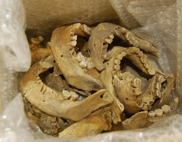
Evidence for prehistoric human dismemberment found at Carrowkeel, Ireland
The ancient people of Ireland have provided new insights into the death rites. And they’re a bit disgusting. A little disgusting. The New Zealand University of Otago ‘s Anatomy Department has studied ancient Irish funerals. The results were published in the Bioarchaeology International journal.
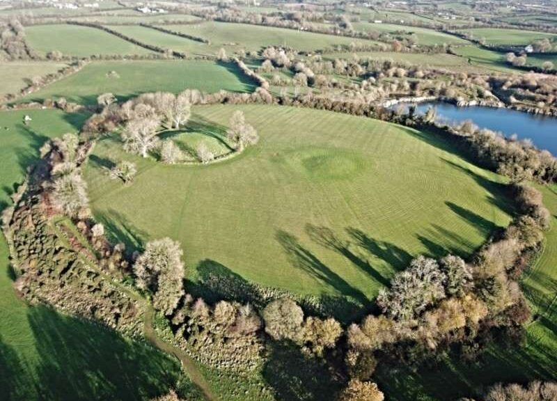
Dr. Jonny Geber, the lead author of the new paper, focuses on the Passage Tomb Complex, which is 5,000 years old at Carrowkeel in County Sligo in northwestern Ireland.
This place is one of Europe’s most remarkable ritual landscapes. But despite that, is relatively unknown.
Cairn K – Part of a 5000-year-old Passage Tomb Complex at Carrowkeel in County Sligo in the north-west of Ireland. This site is one of the most impressive Neolithic ritual landscapes in Europe, but despite that, is relatively unknown.
The research team analyzed bones from up to seven passage tombs that included both unburnt and cremated human remains from around 40 individuals. Much remains unknown about these Stone Age people.
Dr. Geber says he and his colleagues determined that the unburnt bone displayed evidence of dismemberment.
“We found indications of cut marks caused by stone tools at the site of tendon and ligament attachments around the major joints, such as the shoulder, elbow, hip, and ankle,” he says.
Cut marks on some of the human remains which were discovered at Carrowkeel Cut marks, marked in white (above) and magnified (below), observed on a left humerus (upper arm) from Cairn K (a), the ilium of a left coxae (part of the pelvis) from Cairn K (b), and a right femur (upper leg) from Cairn K (c)
One of the 18 boxes re-discovered in the Duckworth Laboratory at the Leverhulme Centre for Human Evolutionary Studies, University of Cambridge, England.
Dr. Geber says the new evidence suggests that a complex burial rite was undertaken at Carrowkeel, which involved a funerary rite that placed a particular focus on the “deconstruction” of the body.
“This appears to entail the bodies of the dead being ‘processed’ by their kin and community in various ways, including cremation and dismemberment.
It was probably done with the goal to help the souls of the dead to reach the next stages of their existence.”
This study has been able to show that the Carrowkeel complex was most likely a highly significant place in Neolithic society in Ireland and one which allowed for interaction and a spiritual connection with the ancestors.
The evidence suggests that the people of Neolithic Ireland may have shared similar beliefs and ideologies concerning the treatment of the dead with communities beyond the Irish Sea, according to the researchers, Dr. Geber says.
So if an Irish relative proposes dismembering you after death, don’t be offended, they are just following original Irish burial rites. Ick!
Evidence of Iron Age temples uncovered at Navan Fort
During an examination of the Navan Forts in Co Armagh, Queen’s boffins uncovered evidence of a huge temple complex. The discovery at Ulster’s mythical capital, known as Emain Macha, could date back as far as the Iron Age.
The research was worked together by scholars from Queen’s, the University of Aberdeen, and the German Archaeological Institute, Frankfurt.
They believe it evidences a vast temple complex and ceremonial center of prehistoric Europe, as well as the first evidence of continued medieval activity when Navan Fort was associated with the kingship of Ulster.
Dr Patrick Gleeson, Senior Lecturer in Archaeology at the School of Natural and Built Environment at Queen’s, said: “Excavation in the 1960s uncovered one of the most spectacular series of buildings of any region of prehistoric Europe, including a series of figure-of-8 buildings of the Early Iron Age and a 40m timber-ringed structure constructed c.95 BC.
“Upon the latter’s construction, it was immediately filled with stones and burnt to the ground in order to create a massive mound that now dominates the site.
“Our discoveries add significant additional data, hinting that the buildings uncovered in the 1960s were not domestic structures lived in by kings, but a series of massive temples, some of the largest and most complex ritual arena of any region of later prehistoric and pre-Roman Northern Europe.”
The survey’s findings will be published in the Oxford Journey of Archaeology.
Navan Fort was one of Ireland’s so-called Royal sites – a group of five ceremonial centers of prehistoric origins that were documented in medieval times as the capitals of the five fifths that divided Ireland.
It is hoped this work to uncover what was once at Navan will “add rich discoveries to the iconic site of Navan Fort”.
But these efforts, which are part of the Comparative Kingship project funded by the Leverhulme Trust, and supported by Historic Environment Division of the Department of Communities, are in their initial stages.
Dr. John O’Keeffe, Principal Inspector of Historic Monuments in the Department for Communities, said: “We were pleased to facilitate the survey work at Navan Fort, which is owned by the Department for Communities and is one of 190 State Care Monuments in Northern Ireland managed by the Department for Communities.
“The work has shone new light on the monument and will inform further research as we explore what Navan Fort meant to our forebears and how they used the site, for years to come.
“It provides additional insights that inform visits to this enigmatic monument and landscape today.”
Navan Fort is one of Ireland’s most ancient landscapes because it is the seat of legendary kings, like Chonchobhar and mac Nessa, and provides the backdrop to the exploits of warriors like Cú Chulainn, Conal Cernach and others in the great epic saga Táin Bó Cuailainge, or the Cattle Raid of Colley.
In addition to identifying residences of early medieval kings of Ulster, activity at Navan Fort is contemporary with the foundation of Armagh by St Patrick only 1km to the east. Some of the buildings uncovered are likely to be identifiable with the house built by Níall ÓG Ua Neill for all the poets of Ireland in 1387.
It also appears that activity continued at Navan after the coming of Christianity and the foundation of Armagh, the primatial see of the Church in Ireland, is particularly significant.
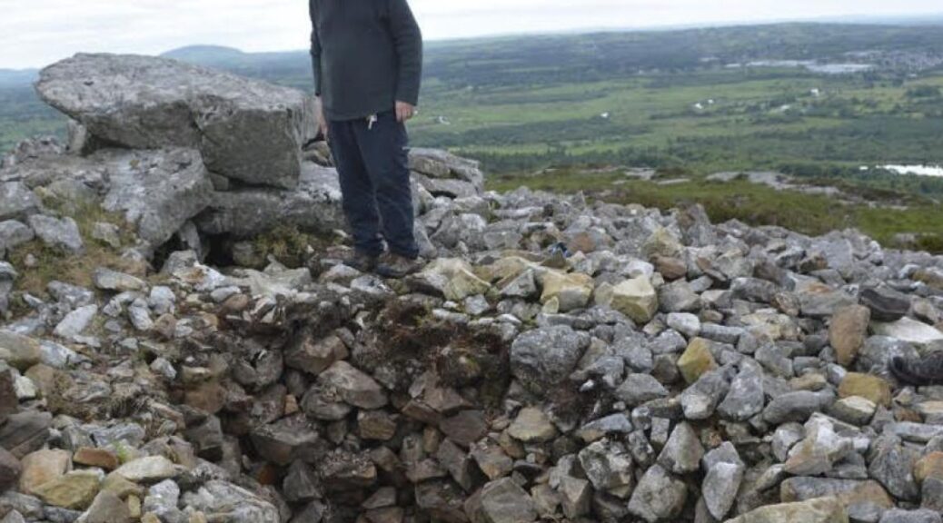
5,000-year-old Sligo tombs being destroyed by vandals, say archaeologists
Five-thousand-year-old Neolithic tombs in Co Sligo are suffering damage and vandalism “on a scale never seen before” and will not survive unless action is taken immediately, archaeological experts have warned.
There are 75 passage tombs in Co Sligo, almost one-third of the estimated 240 in the State, according to the Sligo Neolithic Landscapes Group, which is pressing for the county’s Neolithic heritage to be deemed a World Heritage Site by Unesco.
In County Sligo, almost a one-third of all Neolithic tombs in the Republic of Ireland are found with a total of 75 tombs.
A Megalithic passage tomb in Carrowkeel is one of several that has been damaged in recent weeks.
The Sligo Neolithic Landscapes Group said that so much material had been taken from one passage tomb – Teach Cailleach a’ Bheara (the House of the Witch) – that there is now a hole large enough for an adult to lie in.
Dr. Robert Hensey, a neolithic expert, said that people are walking on top of some cairns so frequently that there is now a fear that they will be lost during this generation.
“Not only is there a fear that they won’t be there for future generations, but they may also be lost to this generation,” Hensey told the Irish Times.
The Sligo Neolithic Landscapes Group is advocating for the county’s neolithic heritage to be deemed a Unesco World Heritage Site and warned that the landscape is “very fragile” and under an “existential threat.”
Increased footfall has additionally damaged one of Sligo’s best-known landmarks, Dr. Hensey warned. Queen Maebdh’s cairn on the top of Knocknarea has suffered walking scars, according to Hensey, due to the increased traffic.
The megalithic passage grave at Carrowkeel has also been plagued by graffiti, with several people scratching their names into the stones, potentially damaging the megalithic art.
Hensey additionally said that some people have been stealing quartz from some tombs to sell online, while others are looking for secret passages at tombs in the hope of finding undiscovered chambers containing treasures of gold or bronze.
Martin Kenny, a Sinn Féin TD for Sligo, Leitrim, North Roscommon, and South Donegal, is calling on Michael Malcolm Noon, the Minister for State for Heritage. to take action against the vandalism and to support the Sligo Neolithic Landscape Group in their bid to make the landscape a World Heritage Site.
He said that he has also invited the Minister of State to visit Sligo and see the tombs for himself.
“I have invited the minister of state to visit Sligo and see the sites for himself and he assures me that he will take action, immediately, to protect the tombs,” Kenny told the Leitrim Observer.
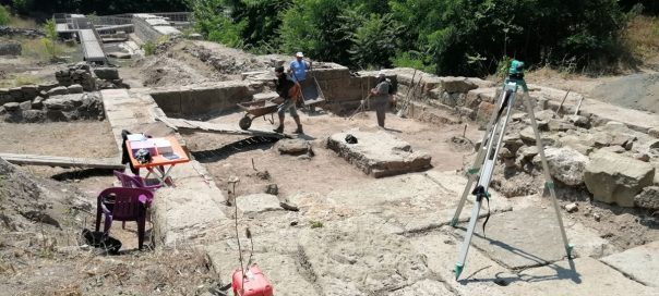
Roman-Era Coins Unearthed at Spa Complex in Bulgaria
More than 40 ancient coins, most of which from the 4th century CE, have been discovered since the excavations were started in the summer of 2020 on the site Aquae Calidae near Bourgas on the southern Bulgarian Black Sea coast.
This was announced by the head of the archaeological dig, Associate Professor Dimcho Momchilov. During the current archaeological season, excavations are being carried out in the north-eastern sector of the complex.
“The idea is, if possible, to complete the northeastern apoditerium (vestibule) of the ancient, early Byzantine and medieval bath this year,” Momchilov said.
This will be followed by partial conservation and restoration. Among the interesting new finds from the current archaeological season is a monumental step that bore a roof structure.
Momchilov said that remnants of construction from the Roman period, and the Roman period, had been found. Apart from the coins, other items from the fourth century CE had been found.
“Our desire is to explore the shaft we found east of the building. It is from an early period and is very interesting. There are partially preserved water pipes and we will try to open it this year.
It had a variety of materials, but only after when I open it, I can say how long it has been for sure. In any case, for me, this shaft is connected with the early Roman bath, and the construction of the whole early Byzantine bath was in accordance with this shaft,” he said.
Excavations at the Aquae Calidae archeological complex are scheduled to continue until the end of July. Aquae Calidae Thermopolis originated around the warm Bourgas mineral springs in Thracian times, in the first millennium BCE.
The Thracians turned the hot spring into a revered sanctuary of the Three Nymphs. The spa complex has an area of six acres. In the north-south direction, its length is 86 meters.
In the late Middle Ages, Aquae Calidae became known as Therma or Thermopolis. By the sixth century, the settlement already had expanded baths and fortress walls.
In the 16th century, Ottoman ruler Sultan Suleiman the Magnificent built a contemporary Turkish bath at the site.