Geologists Map Secret Tunnel And Chamber Found Beneath Aztec Pyramid
“Teotihuacan, translated from the Aztec language as “birthplace of the gods,” or “a place where gods were born,” was a very important religious and cultural center during the Aztec empire.
Less than a decade ago, archaeologists uncovered an almost 60-foot Vertical shaft under the Avenue of the Dead.
Excavation of the tunnels beneath the Avenue was not possible, but in 2017 a team of geologists used electrical resistivity mapping to map the underground beneath the Avenue of the Dead.
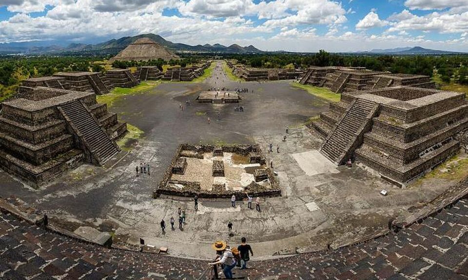
Panoramic view from the summit of the Pyramid of the Moon, with the “Avenue of the Dead”, in Teotihuacan.
This archaeological site in modern-day Mexico is famous for its broad central “Avenue of the Dead,” surrounded by a dozen pyramids and platforms. The 150 feet high Pyramid of the Moon was built in successive phases and construction completed between 200 and 250 CE. The nearby Pyramid of the Sun is even higher at 216 feet.
Excavation revealed a system of tunnels and chambers. Human remains and diverse objects made from green obsidian, a type of volcanic rock used in religious rituals, were recovered.
A worker removes dirt from a tunnel discovered under the Pyramid of the Plumed Serpent. So far, 70,000 objects of interest have been found there.
The extent of this tunnel-system remains uncertain to this day. Archaeologists suspected that the tunnels follow the pattern of the streets and pyramids on the surface.
As excavation of the complete site was not possible, in 2017 a team of geologists used electrical resistivity imaging to map the underground beneath the Avenue of the Dead.
Electrical resistivity imaging is a geophysical technique used also on other archaeological sites to map the composition of the underground, revealing large subterranean cavities or the presence of groundwater.
The researchers discovered a tunnel at a depth of 26 feet, that starting from the center of the avenue runs to 49 feet in diameter large cavity hidden beneath the Pyramid of the Moon.
Electrical resistivity data visualization under the Pyramid of the Moon.
The age and the use of this network of tunnels and chambers remain uncertain. The walls of the excavated tunnels were covered with pyrite powder.
Visitors would see the grains of this yellow mineral glitter in the light of torches, an effect resembling the stars of the celestial sphere. It was suggested that the tunnel-system acted as a symbolic gateway, connecting the sky with the underworld, and played an important role in religious rites.
The origin of the tunnel-system – and the city – are still being studied. Centuries later, the Aztecs built some towns on the site of the ancient city, but it’s not yet clear if they used the preexisting tunnel-system.
Around 300 CE, the tunnels appear to have been sealed off and nobody knows why or what the chamber may hide.
The Rome of America: What Lies Under Teotihuacan? – The Real City of the Gods
It was one of the first large cities in the Western Hemisphere, the Huge. And its origins are a mystery. About a thousand years before the gradual arrival in central Mexico of the Nahuatl-speaking Aztec, it was built by hand. But it was the Aztec, descending on the abandoned site, no doubt falling awestruck by what they saw, who gave its current name: Teotihuacan.
According to George Cowgill, an archaeologist at Arizona State University and a National Geographic Society grantee—Teotihuacan, a famous archaeological site less than 30 miles (50 kilometres) from Mexico City, Teotihuacan reached its zenith about 100 B.C. And A.D. 650.
It covered 8 square miles (21 square kilometres) and supported a population of a hundred thousand.
“It was the largest city anywhere in the Western Hemisphere before the 1400s,” Cowgill says. “It had thousands of residential compounds and scores of pyramid-temples … comparable to the largest pyramids of Egypt.”
Oddly, Teotihuacan, which contains a massive central road (the Street of the Dead) and buildings including the Temple of the Sun and the Temple of the Moon, has no military structures—though experts say the military and cultural wake of Teotihuacan was heavily felt throughout the region.
Who Built It?
Cowgill says the site’s visible surface remains have all been mapped in detail. But only some portions have been excavated.
Scholars once pointed to the Toltec culture. Others note that the Toltec peaked far later than Teotihuacan’s zenith, undermining that theory. Some scholars say the Totonac culture was responsible.
No matter its principal builders, evidence shows that Teotihuacan hosted a patchwork of cultures including the Maya, Mixtec, and Zapotec.
One theory says an erupting volcano forced a wave of immigrants into the Teotihuacan valley and that those refugees either built or bolstered the city.
The main excavations, performed by Professors Saburo Sugiyama of Aichi Prefectural University in Japan and Rubén Cabrera, a Mexican archaeologist, have been at the Pyramid of the Moon.
It was there, beneath layers of dirt and stone, that researchers realized the awe-inspiring craftsmanship of Teotihuacan’s architects was matched by a cultural penchant for brutality and human and animal sacrifice.
Inside the temple, researchers found buried animals and bodies, with heads that had been lobbed off, all thought to be offerings to gods or sanctification for successive layers of the pyramid as it was built.
Since 2003, archaeologist Sergio Gomez has been working to access new parts of the complex and has only recently reached the end of a tunnel that could hold a king’s tomb.
It’s unclear why Teotihuacan collapsed; one theory is that poorer classes carried out an internal uprising against the elite.
For Cowgill, who says more studies are needed to understand the lives of the poorer classes that inhabited Teotihuacan, the mystery lies not as much in who built the city or in why it fell.
“Rather than asking why Teotihuacan collapsed, it is more interesting to ask why it lasted so long,” he says. “What were the social, political, and religious practices that provided such stability?”
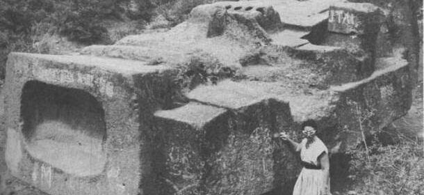
Megalithic stone blocks scattered in the vicinity of the pyramid of the Feathered Serpents at Teotihuacan.
Megalithic stone head from the earlier layer of construction.
Megalithic stone blocks scattered in the vicinity of the pyramid of the Feathered Serpents at Teotihuacan.
Megalithic stone blocks scattered in the vicinity of the pyramid of the Feathered Serpents at Teotihuacan.
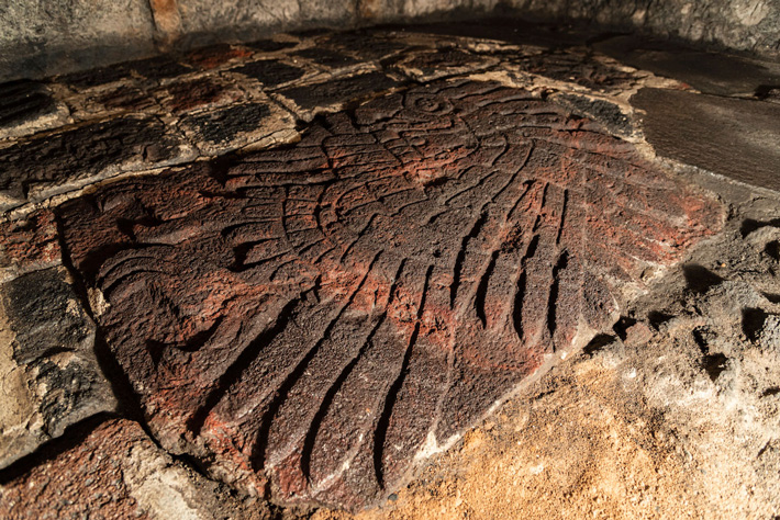
According to a statement released by Mexico’s National Institute of Anthropology and History (INAH), archaeologists led by Rodolfo Aguilar Tapia have uncovered a bas-relief sculpture of a golden eagle in the floor of the Aztec chapel dedicated to Huitzilopochtli at the Templo Mayor.
The well-preserved floor surface was covered during an expansion of the temple before the arrival of the Spanish in Tenochtitlan in the sixteenth century, Tapia explained.
“From what we have seen through photographs, it is a very beautiful piece that shows the great secrets that the Templo Mayor of Mexico Tenochtitlan has yet to reveal to us. I want to extend my appreciation to the INAH archaeologists who collaborate in this space, since, thanks to their effort and dedication, we can continue to recover our history and our memory.
Due to the health contingency, the fieldwork has had to be postponed, however, it is clear that there is also an important work of research and academic reflection that has not stopped “, said the Secretary of Culture, Alejandra Frausto Guerrero, about this notable finding.
Although it was in February 2020 when a multidisciplinary team concluded the release and cleaning of this itzcuauhtli , a Nahua voice that means “obsidian eagle”, and with which the Mexica referred to the golden eagle ( Aquila chrysaetos canadensis ), it is now, when his investigation in the cabinet has been deepened, the finding is made known.
Carved on red tezontle and with dimensions of 1.06 meters long by 70 centimetres wide, this bas-relief is the largest in a set of 67 similar elements found so far in the Templo Mayor.
According to specialists, the relevance of the sculpture is denoted not only by its size and finish but also by its location, at the foot of the most important building for the Mexica and in the central axis that crosses the ‘chapel’ of Huitzilopochtli and the monumental sculpture of the goddess Coyolxauhqui. It is also close to Cuauhxicalco, a circular building whose name translates as “place of the eagle’s gourd”, where, according to 16th-century documents, the ritual cremations of the Tenochca rulers were carried out.
At 1.06 meters long and 70 centimeters wide, it is the largest of the set of similar sculptural pieces found so far. It was located at the foot of the Templo Mayor, in the central axis of the ‘chapel’ dedicated to Huitzilopochtli; would correspond to the government of Motecuhzoma Ilhuicamina (1440-1469 AD)
Regarding the discovery of the bas-relief, the archaeologist assigned to the PTM, Rodolfo Aguilar Tapia, who investigated the piece together with the interns in archaeology Mary Laidy Hernández Ramírez and Karina López Hernández; and in physical anthropology, Jacqueline Castro Irineo, from the National School of Anthropology and History, reported that it was verified during the ninth field season of the PTM.
This season, directed by the head of the Project, the archaeologist Leonardo López Luján, has focused on exploring under the ‘liga bridge’ that connects the streets of Guatemala and Argentina, wherein pre-Hispanic times the west plaza of the Sacred Precinct was located of Mexico-Tenochtitlan. The sculptural carving was part of a floor of that space, which would have been in use during the government of Motecuhzoma Ilhuicamina, between the years 1440 and 1469 of our era.
“This floor is unique in the entire Templo Mayor as it contains bas-reliefs that allude to the dual conception of the building. On the south side, where we are exploring, there are elements like this eagle, linked to the mythical cycle of the birth of Huitzilopochtli; while to the north, the bas-reliefs located earlier —the first in 1900 by Leopoldo Batres, and the later by the PTM and the Urban Archeology Program (PAU) – contain representations associated with Tláloc, the water cycle and the regeneration of corn “.
Aguilar Tapia specifies that thanks to the work carried out by archaeologists Eduardo Matos Moctezuma and Leonardo López Luján, today there is a defined stratigraphic correspondence, which allows researchers to know in which construction stage of the Templo Mayor the findings are located, and at what time belong the same.
Thus, he exemplifies, when the exploration at the aforementioned intersection began, the floor that the archaeologists saw was from Stage VI of the Templo Mayor, corresponding to the government of Ahuítzotl between 1486 and 1502, while now, after meticulous excavations, specialists have managed to reach Stage IV-a, that is, they have gone back in time to the 1440s and to the period of government of Motecuhzoma I.
The aforementioned plaza floor was covered since pre-Hispanic times during the expansion of the Templo Mayor. “That is why it has a good state of conservation,” says the researcher, noting that “it is an element that was never seen by the Spanish.”
The symbolism of the golden eagle
The pause in the fieldwork that the COVID-19 pandemic brought with it, allowed the PTM researchers to carry out the investigation of various elements, including the bas-relief. Among other aspects, the iconographic representations that exist of the golden eagle in historical sources such as the codices were studied, in order to correlate them with the sculpture discovered at the foot of the Templo Mayor.
One of those representations, Aguilar Tapia points out, is in Plate 50 of the Codex Borgia, where a golden eagle is shown posing on top of a mesquite tree, a tree that rises from a stark deity. “The interesting thing is that this image is iconographically very similar to the bas-relief that we find in the field, in both representations the feathers end in the shape of sacrificial knives, which allude to the Nahua name of the bird: obsidian eagle.”
For the Mexica, this bird of prey was closely related to war and sacrifice, while it was considered a nahual of the sun and, therefore, also of its tutelary god, Huitzilopochtli.
In the incoming seasons of the PTM field, the researcher concludes, the actions will focus on completing the exploration of the floor where the bas-relief is located to look for more others and then, with extreme care, temporarily remove them and be able to investigate under them in search of offerings or other architectural elements. “After all this exploratory process, with the support of restoration specialists, we will place each bas-relief in its precise place”, he concludes.
Similar elements could also be found when the excavations around Cuauhxicalco are resumed. The intention of the PTM is that, after its investigation, the bas-reliefs can be shown to the public in their original position: at the west foot of the Templo Mayor.
City Found 360 Feet Below Missouri City, Giant Human Skeleton Found
When coal miners at Moberly, Missouri were drilling a shaft 360 foot deep, broke into a cavern revealing “a wonderful buried city,” multiple sources reported in 1885.
City Found 360 Feet Below Missouri City, Giant Human Skeleton Found Coal miners in the city of Moberly, Missouri mining a shaft 360 feet deep, broke into a cavern revealing “a wonderful buried city,” multiple sources reported in 1885. Incredible rude style masonry and artefacts have been identified.
Masonry and artefacts in extraordinary rude design have been found. Like stone tables, bronze and flint knives, stone and granite hammers, metal statues, metallic saws and a stone fountain that flowed with “perfectly pure water”, which was found to be impregnated with lime.
“Lying beside the fountain where portions of a human being and from the measurement of the bones, it concluded that when alive the figure was three times the size of an ordinary man and possessed of wonderful muscular power and quickness. “, according to the St Paul Daily Globe.
The Semi-Weekly South Kentuckian published the measurements of the giant’s leg, “The bones of the leg were measured, the femur measuring 4 and 1/2 feet, the tibia four feet and three inches. The head bones had separated in two pieces, the sagittal and cornal suturis having been destroyed”
The city was arched in by a hard and thick stratum of lava. The civilization used a regularly laid out road system enclosed by walls to travel around. A hall was discovered wherein were stone benches, tools of all descriptions for mechanical service.
The searching party spent twelve hours in the depths and only gave up explorations because of the oil in their lamps being low. No end to the wonderful discovery was reached.
The statues were not accurately made as those made by the mechanics in the year 1885, however, they demonstrated much skill and evidence of an advanced civilization.
The facts above are vouched for by Mr David Coates, the recorder of the city of Moberly, and Mr George Kealing, City Marshall, who were of the exploring party.
I could find no record of the 2nd exploration. Perhaps in the historic papers on film, in the town of Moberly, information may still exist.
In order to find 8 newspaper stories, I needed to search “stratum of lava” 1884-1886.
In an odd coincidence the terms “cave + Missouri”, “Missouri + cave + coal mine”, “Missouri cave fountain”, “Missouri gaint” and countless other rational terms would not locate these articles on the library of congress website.
It seems you need to be clever in your search terms in order to locate historical articles that are relevant.
Experts find 2,000 ruin sites near the Maya train route project in Mexico
Archaeologists in Mexico have provided a study from specialists that cites have more than 2,000 pre-Hispanic ruins or clusters of artifacts along the planned path of the president’s controversial “Maya Train” project on the Yucatan peninsula.
The discovery of sites using LiDAR elevation mapping technology could slow down the already disputed project, which opponents contend also threatens indigenous communities and water supplies.
The laser elevation data showed a total of 2,187 “archaeological monuments” along 277 miles (366 kilometers) of the proposed route, about one-quarter of the total planned track. Experts already knew about the existence of some of the sites, but some are new.
Tourists walk at the Mayan ruins of Chichen Itza in Mexico’s Yucatan Peninsula. Experts in Mexico said Wednesday, Oct. 14, 2020, that they have detected more than 2,000 pre-Hispanic ruins or clusters of artefacts along the proposed route of the president’s controversial Maya Train project on the Yucatan peninsula, which could slow down the already disputed project
The term “monuments” can mean many things, ranging from the remains of a pre-Hispanic Maya home, or carved stones, all the way up to remains of temple platforms.
It was not clear how many of each type of artifact was detected, but Mexico’s National Institute of Anthropology and History said at least 91 were large-scale structures like plazas, pyramid or temple platforms.
Mayan houses were generally relatively insubstantial, with stone bases topped by thatch and wooden structures of which little remains.
The institute said in a statement that the builders of the train would have to take “specific measures” to avoid damaging the artifacts, but did not say whether that meant parts would have to be re-routed.
In July, President Andres Manuel Lopez Obrador inaugurated the start of construction on the “Maya Train,” a pet project of his that would run some 950 miles (about 1,500 kilometers) in a rough loop around Yucatan.
The train is intended to connect Caribbean beach resorts to the peninsula’s interior, with largely indigenous populations and ruin sites, in a bid to stimulate economic development around its 15 stations. The government says it will cost as much as $6.8 billion, but others say it will be much more.
Critics say Lopez Obrador rammed through the project without adequate study of its effects on the environment, underground sinkhole caves known as cenotes, and ruin sites.
Some stretches of the route already have tracks, and the institute said some artifacts had already been disturbed by railway construction decades ago.
But other stretches are to push through sensitive jungle terrain, though they will parallel existing roads or transmission lines. Even where an old railway line exists, the project would imply updating tracks and building new stations.
Some Mayan communities have filed court challenges against the project, arguing that it will cause environmental damage. They also say they were not adequately consulted about it or they will not share in its benefits.
LiDAR, which stands for Light Detection and Ranging, involves shooting a pulsed laser at the ground to get a high-resolution, detailed image of the surface, even through dense vegetation.
The Mayas formed a sprawling empire of city-states across the Yucatan and Central America between 2,000 B.C. and A.D. 900, and their descendants still live on the peninsula.
Archaeologists Unearthed a 15,800 Year Old Stone Tool In Oregon
Recently, an artifact that was unearthed in Oregon and was identified as an “ ancient Swiss army knife,” may have been the oldest artifact so far found in western North America.
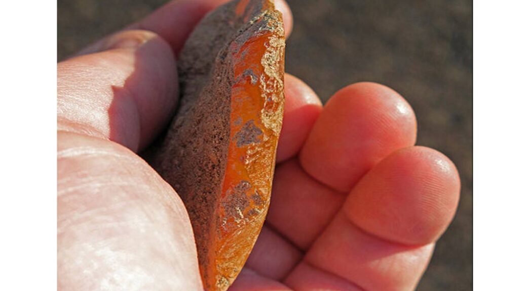
The simple stone tool, hewn from a piece of bright orange agate, was unearthed near a shallow cave that has already turned up evidence of early human occupation — including stone points, tools, and charcoal-stained hearths — dating back as much as 12,000 years. But this artifact was found even deeper in the region’s sandy clay, beneath a layer of volcanic ash that experts have found to be 15,800 years old. If its age is confirmed, the tool would be nearly 3,000 years older than the widespread artifacts of the Clovis culture, once thought to be the continent’s earliest inhabitants.
“This is really exciting,” said Stephen Baker, spokesman for the Oregon office of the U.S. Bureau of Land Management, in an interview. “But of course there’s more research to do.” The hand-sized tool was first unearthed in 2012 by the University of Oregon’s archaeology field school, at a site in south-central Oregon known as Rimrock Draw Rockshelter, on BLM land. The fact that it was found beneath — and was therefore presumably older than — the layer of ancient ash was “fascinating” in itself, Baker said. After a chemical analysis of the artifact revealed that it also contained traces of proteins from bison, confirming that it had been used as a tool.
Ancient bison skeleton from the La Brea tar pits in California
This orange agate stone tool, found buried beneath a layer of 15,800-year-old volcanic ash, may be the oldest artifact yet found in western North America, archaeologists say.
“Getting this bison residue further corroborated the idea that it was a tool, likely used for butchering,” Baker said. Dr. Patrick O’Grady of the University of Oregon, who has been leading the excavations, said that the discovery came about after his field school uncovered debris from an ancient rockfall near the cave.
“Our excavation units had reached a jumbled layer of rockfall that appeared to be the result of a collapse of portions of the rock shelter face,” O’Grady said in an interview.
“We wanted to break that material up and clear a path so we could continue excavating to the bedrock underneath.” Beneath the debris, the team found large fragments of tooth enamel from an extinct species of camel. And beneath those, they hit a sudden, even layer of volcanic ash and rock, called tephra. Experts from Washington State University analyzed the ash, and were able not only to radiocarbon date it to about 15,800 years ago, but were also able to isolate its source: Washington’s Mount St. Helen’s.
Now sagebrush country, the terrain around Rimrock Draw Rockshelter was likely much wetter when the artifacts found there were originally used.
“We found the stone tool 20 centimeters under the Mount St. Helen’s tephra, in dense sandy clay sediment,” O’Grady said. Baker, of the BLM, said researchers quickly identified the object as a tool.
“When they found it, they kind of joked that it was like an ancient swiss army knife,” he said.
“One edge, they believe, was used for scraping animal hide, and another side that’s been worn down over the years they believe was used for carving wood or bone. So, there are a couple of theories, but they think this is kind of a multi-purpose tool.”
The archaeologists were also struck by the tool’s unusual material, he added. It’s this bright orange agate, Baker said. “In that area, there’s a lot of obsidian, but they’d never seen this material in that area before. So it really raises a lot of questions.
“They’re fascinated with, how did this tool get here? Where did it come from? What did they use it for?”
O’Grady agreed that the use of agate is unusual for the region, and potentially significant.
“It is much less common in eastern Oregon sites than obsidian,” he said of the agate.
“My take is that older points tend to be made of [materials like agate] more often than obsidian.” For archaeologists, this new discovery readily invites comparison with a similar find made nearby — at Oregon’s Paisley Caves, just 200 kilometers away, wherein 2008 animal bones and human feces were found that dated to about 14,300 years ago. While those finds, too, remain controversial, both men acknowledge that the Paisley Cave samples gave scientists more to work with than what they have so far at Rimrock Draw.
Sites around the rock shelter have turned up other evidence of early human occupation, including these obsidian stone points, flakes, and hearths dating back as much as 12,000 years.
The comparison with the Paisley Caves is just kind of inevitable, Baker said. Paisley Caves is just a perfect situation because there they found many, many samples. But in this situation [at Rimrock Draw], they have just a couple of pieces of evidence in one particular area that they need to expand and add more evidence too.
“So we’re in the very early stages of this.”
O’Grady agreed, adding that it’s too early to begin finding a place for Rimrock’s ancient orange tool in the timeline of American pre-history. We all know the significance of the Paisley Caves site, with the exquisite fieldwork, the sequence of radiocarbon dating, and well-dated human fecal material that has firmly placed the site among very few in the Americas that are established as pre-Clovis occupations, he said.
In an attempt to find a comparable body of evidence, he added, the coming field season at Rimrock Draw will be devoted largely to identifying the size of the 15,800-year-old layer of volcanic ash, and testing to see if more artifacts await beneath it. Rimrock has to produce strong dateable evidence through either cultural features or stratigraphic time markers to begin any conversation about its place in the realm on pre-Clovis sites,” O’Grady said.
“We have a hint of such a possibility through the association of the orange flake tool 20 centimeters under the Mount St. Helens tephra. But, it is only that — a hint — until we can show that the tephra is widely distributed across the site and that artifacts are found consistently underneath it.
“It is at that point that the work really begins,” he continued, “to verify the relationship in collaboration with other Paleoamerican researchers and conduct vast amounts of geological and archaeological analyses to firmly establish the relationship. It is that next step that must be approached very carefully, to watch warily for the older signs, and we are moving toward it with caution, but also with hopeful optimism.
Did the Celts build “America’s Stonehenge” 4,000 years ago?
Studying the origins of the aptly named Mystery Hill megaliths, also known as America’s Stonehenge, whets one’s curiosity but does not satisfy—unless one is satisfied by the excitement of confounding mystery alone.
A structure at Mystery Hill, also known as America’s Stonehenge. It may not look quite as impressive as the UK’s Stonehenge, but it also hides many alluring secrets.
The site, in North Salem, N.H., includes stone monoliths and chambers spread across 30 acres. The stones are said to have complex astronomical alignments. A 4.5-ton stone slab that seems to be the focal point of the site may have served as an altar for sacrifice. It is grooved with a channel for draining, possibly the blood of a victim.
A variety of characteristics have fueled a theory that America’s Stonehenge was built by Europeans as long ago as 2,000 B.C.—thousands of years before the first evidence of Viking settlement in North America. Archaeologists are divided. Some say the evidence is lacking to support this theory and that the site may have been constructed in relatively recent times.
Many similar sites are found on the stretch from Maine to Connecticut, though none as expansive as Mystery Hill. Here’s a look at the site’s characteristics and the views of various experts.
Why it May Have Been the Celts
1. Glyphs seem to suggest an archaic Irish language, though any deciphering of the glyphs has been controversial.
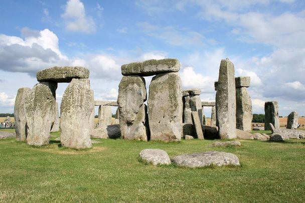
2. It seems from the astronomical alignment that the megaliths mark cross-quarter holidays. These holidays are only celebrated by the Celts, according to astronomer Alan Hill. Some have compared the megaliths to Stonehenge.
3. “Carbon-14 results coincide with the date of a major immigration by Celts,” according to a book by David Goudsward and Robert Stone titled “America’s Stonehenge: The Mystery Hill Story, from Ice Age to Stone Age.” Stone bought the site in the 1950s and opened it to public viewing and to further research. Goudsward and Stone continue: “The Celtiberians [Celtic-speaking people of the Iberian Peninsula] interacted with Carthaginians, a nationality almost certain to have the skill to cross the Atlantic. However, there is not of the ornamentation on the stones that would be indicative of Celts.”
A structure at the Mystery Hill site.
Why it May Have Been the Natives
1. Archaeologists have found Native American artefacts on-site that are more than 1,000 years old.
2. The use of stone-on-stone tools shows workmanship similar to that employed by Native Americans.
Glyphs of the Celts?
An example of Ogham
Ogham is an Irish script used in the fifth to sixth centuries that consists of crosshatches. Glyphs that may be ogham are said to have been found on the stones.
Karen Wright, who wrote an article for Discovery Magazine in 1998 after visiting Mystery Hill, described what she felt to be dubious deciphering: “Various authors [have made interpretations,] consulting languages from ogham to Russian. The most baroque interpretation, a translation based on Iberic/Punic, was ascribed to three evenly spaced parallel grooves in a rust-coloured cast: ‘In Baal, on behalf of the Canaanites this is dedicated,’ read the translation.
“This, I decided, was the archaeological equivalent of the scene from Lassie in which the dog barks once and Jimmy is given to understand that the leg of a six-year-old girl named Sally has been trapped under a fallen tree 30 yards north of the falls on Coldwater Creek near the old mine shaft and oh, by the way, she’s diabetic too, so bring some insulin.”
A structure at the Mystery Hill site.
Carbon Dating
In 1969, archaeologist James Whittall unearthed stone tools at the site, along with charcoal flakes that could be carbon dated. The dating showed the tools’ user was working around 1,000 B.C., according to Goudsward and Stone.
Whittall recovered charcoal from several other locations on-site and carbon dating ranged from 2,000 B.C. to 400 B.C.
Dating Using Astronomical Alignments
Astrological alignments concur. Astronomer Dr. Louis Winkler, the principal site scientist, found the positions of some stones align with where the stars and other celestial objects would have been about 2,000 years ago. He has also done radiocarbon and laser theodolite dating to support a Bronze Age origin (2,000 B.C.–1,500 B.C.).
Anthropologist Bob Goodby of the New Hampshire Archaeological Society (NHAS) said the alignments are “coincidental.”
“With so much stone around, it wouldn’t be that difficult to find some alignments that correspond to celestial things,” Goodby told Boston University publication the Bridge. This isn’t the only “coincidence” cited by critics of the ancient-European-origin theory, nor the only one cited as a little too “coincidental” by supporters of the theory.
For example, critic Richard Boisvert, New Hampshire’s deputy state archaeologist, admitted the structures resemble ancient European megalithic structures, but that it’s a coincidence. He told Discovery that it’s a case of the same form-fitting the same function.
Professor of astronomy at New Hampshire Technical Institute Alan Hill does not see the astronomical alignments as coincidence. He told New York Times that the megaliths mark cross-quarter days, the halfway points between the solstices and equinoxes. Celts are the only ones to celebrate cross-quarter holidays, he said. Hill dismissed the theory that the structures are cellars built in the past few centuries, partly because the doors are not wide enough to admit wheelbarrows. A local lawyer and mystery novelist, David Brody, told the Times there are too many similarly puzzling stones and structures in the region to write it all off as coincidence.
A structure at the Mystery Hill site.
Stone-on-Stone Tools Suggest Primitive Builders
The builders apparently used stone tools, not metal tools. Boisvert’s boss, New Hampshire state archaeologist Gary Hume, told Discovery the stone-on-stone workmanship is similar to that of Native Americans. He was hesitant to say the megaliths could be 4,000 years old, but he seemed to leave the possibility open. He said he wasn’t going to question “the two reputable surveyors who had vouched for the alignments,” wrote Wright.
The Natives and the Celts are not the only groups archaeologists have pinned as the potential builders. Some say it may have been the Phoenicians, the people of an ancient kingdom on the Mediterranean. The standing stones align with the location of the polestar Thuban during Phoenician times, according to Wright.
Jonathan Pattee, a shoemaker and his family lived on the site throughout much of the 19th century, and many say he and his family built the structures. Dennis Stone, Robert Stone’s son who is also currently owner and operator of the site, told Discovery that some of the structures were probably built by Pattee, but certainly not all. Others have also said the intricacies of construction and alignment were not likely carried out by the Pattee family, and the family would have used metal tools, not stone tools.
Goodby and other critics of the ancient-origin theory say archaeologists would have found signs of people living on or near the site, such as burial grounds. He said the sacrificial stone was probably actually a place for inhabitants in more recent history to make soap. Whatever the theories, as Goudsward and Stone write: “There has been so much damage in the last four millennia that no matter who you believe built the site, there is just enough physical evidence to warrant further investigation along that line. This has produced a spectrum of theories as wide and expansive as the skies that may or may not be charted by the ancient monoliths.”
A 9,000-year-old caribou hunting structure beneath Lake Huron
Underwater archaeologists have discovered evidence of prehistoric caribou hunts that provide unprecedented insight into the social and seasonal organization of early peoples in the Great Lakes region.
An article detailing the discovery of a 9,000-year-old caribou hunting drive lane under Lake Huron appears in today’s issue of the Proceedings of the National Academy of Sciences.
“This site and its associated artefacts, along with environmental and simulation studies, suggest that Late Paleoindian/Early Archaic caribou hunters employed distinctly different seasonal approaches,” said John O’Shea, the Emerson F. Greenman Professor of Anthropological Archaeology at the University of Michigan and lead author of the article.
The Drop 45 Drive Lane. (A) A plan showing the major topographic and cultural features associated with the drive lane. Black dots represent the location of placed stones. The hunting blinds incorporated within the main drive lane feature are labelled. The raised cobble surface to the north and west of the drive lane varies from 1 to 2 m higher than the bedrock on which the drive lane stones are located. This plan was produced as an overlay of the acoustic image. (B) An acoustic image of the drive lane produced via a mosaic of scanning sonar images. The scanning unit is the black circular area near the centre of the image, and the red circles surrounding have radii that increase by 15 m. A trace of the second scanning sonar location is visible in the southeast of the image. Light coloured objects are stones that produce a strong acoustic signature, whereas dark areas are acoustic shadows.
Stone tool debris from the Drop 45 Drive Lane. (A) Composite photograph showing the 11 chert flakes recovered from the Drop 45 Drive Lane. (B) The location of archaeological tests on the Drop 45 Drive Lane superimposed on the acoustic image (Fig. 2B). Small white circles represent test locations that did not generate identifiable archaeological debris. Large white circles with black centres represent locations that produced lithic debris. Black centres with adjacent numerals indicate locations that generated multiple lithic remains. North is to the top of the image, and the red circular rings surrounding the scanning sonar placement are incremented in units of 15 m.
Diver and remote operated vehicle collecting samples at Drop 45 Drive Lane in Lake Huron.“In autumn, small groups carried out the caribou hunts, and in spring, larger groups of hunters cooperated.”
According to O’Shea, who is also Curator of U-M’s Great Lakes Division of the Museum of Anthropological Archaeology, the site was discovered on the Alpena-Amberley Ridge, under 121 feet of water, about 35 miles southeast of Alpena, Mich., on what was once a dry land corridor connecting northeast Michigan to southern Ontario.
The main feature, called Drop 45 Drive Lane, is the most complex hunting structure found to date beneath the Great Lakes. Constructed on level limestone bedrock, the stone lane is comprised of two parallel lines of stones leading toward a cul-de-sac formed by the natural cobble pavement.
Three circular hunting blinds are built into the stone lines, with additional stone alignments that may have served as blinds and obstructions for corralling caribou.
Although autumn was the preferred hunting season for caribou, the orientation of Drop 45 shows that it would only have been effective if the animals were moving in a northwesterly direction, which they would have done during the spring migration from modern-day Ontario.
“It is noteworthy that V-shaped hunting blinds located upslope from Drop 45 are oriented to intercept animals moving to the southeast in the autumn,” O’Shea said.
“This concentration of differing types of hunting structures associated with alternative seasons of migration is consistent with caribou herd movement simulation data indicating that the area was a convergence point along different migration routes, where the landform tended to compress the animals in both the spring and autumn.”
The structures in and around Drop 45, and the chipped stone debris for repairing stone tools, provide unambiguous evidence for intentional human construction and use of the feature, O’Shea said. And they also provide important insight into the social and economic organization of the ancient hunters using this area.
Diver and remote operated vehicle collecting samples at Drop 45 Drive Lane in Lake Huron.
“The larger size and multiple parts of the complex drive lanes would have necessitated a larger cooperating group of individuals involved in the hunt,” he said.
“The smaller V-shaped hunting blinds could be operated by very small family groups relying on the natural shape of the landform to channel caribou towards them.”
Co-authors of the article are Ashley Lemke and Elizabeth Sonnenburg of U-M, Robert Reynolds of Wayne State University and Brian Abbot of Nautilus Marine Group International.