FEFU archaeologists have found the oldest burials in Ecuador
Archaeologists of the Far Eastern Federal University (FEFU) found three burials of the ancient inhabitants of South America dated from 6 to 10 thousand years ago.
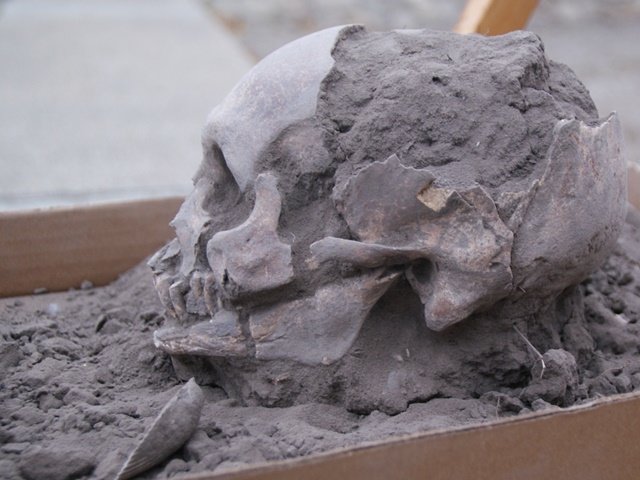
The ancient skull excavated in Loma Atahualpa, Ecuador, 2018, by archaeologists of the Far Eastern Federal University (FEFU)
The excavations were carried out in Atahualpa Anton, Ecuador. The findings belong to the Las Vegas archaeological culture of the Stone Age.
Analysis of artefacts will help scientists understand the development of ancient cultures on the shores of the Pacific Ocean and clarify the origin and development of ancient American civilizations.
Research is being jointly conducted by FEFU and Primorsky Polytechnic University in Guayaquil (ESPOL, Ecuador).
Previously, FEFU scientists investigated the famous Neolithic settlement in Real Alto. In 2018, they decided to study an earlier site in order to trace the development of ancient cultures on the Pacific Coast opposite to the Pacific Coast of Russia (Russian Far East).
“The archaeological site of Loma Atahualpa is more archaic than Real Alto, its materials are transitional from the Mesolithic to the Neolithic.
We excavated three burials that were probably made at different times. This will make it possible to compare their materials and retrieve the new information on the development of ancient cultures in the period from 10 to 6 thousand years ago,” said Alexander Popov, director of the Educational and Scientific Museum of The School of Humanities of FEFU.
Expedition materials are processed by experts from several countries. The stone tools found were examined at Tohoku University (Japan) for traces of mechanical activity in order to understand how they were used. There were also sent samples for radiocarbon dating.
Simultaneously, anthropologists from The Kunstkamera (Peter the Great Museum of Anthropology and Ethnography, St. Petersburg) and the Institute of the Problems of Northern development, Siberian Branch of the Russian Academy of Sciences (Tyumen, Russia) began to study the morphological features of the human remains found.
“In the course of working with Ecuadorian colleagues, we have learned that our research attracted the obvious attention of scientists.
Last year’s symposium, which was organized at the Real Alto Museum, was attended by colleagues from the United States, Canada, Brazil, Japan, Poland and other countries.
We also cooperate with partners from several European countries and the Russian Academy of Sciences,” said Alexander Popov.
5700-year-old child skeleton unearthed in the Turkish city of Malatya
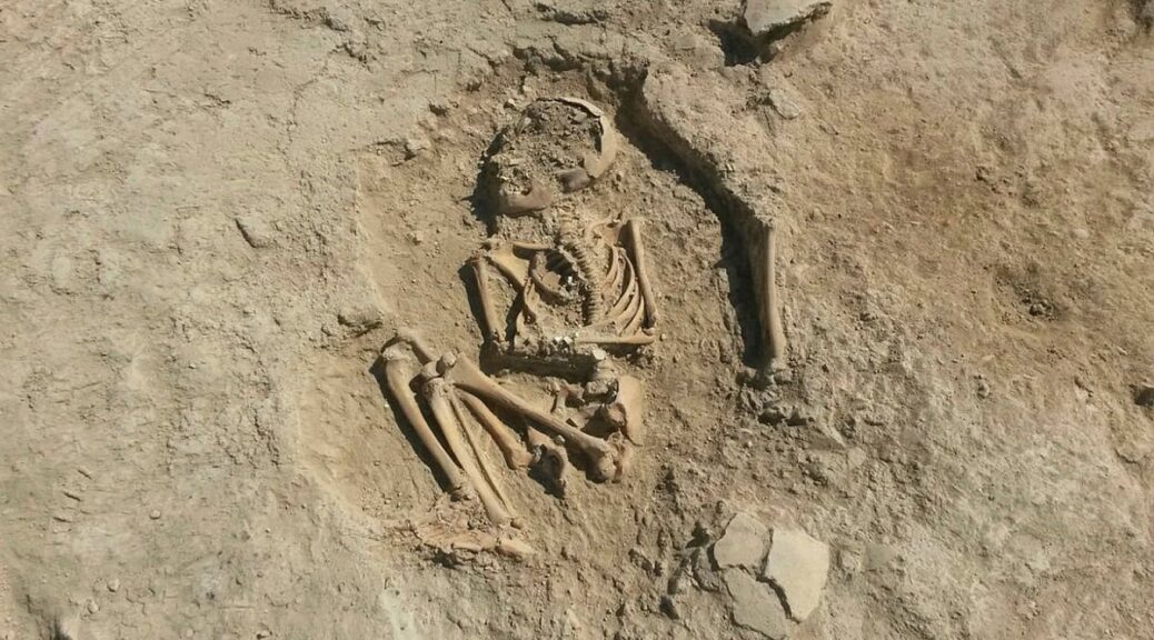
A 5,700-year-old skeleton of a noble-born child has been found buried in the ruins of a Copper Age Turkish house. Anthropologists believe the bones belonged to a six-year-old who most likely died of trauma in the fourth millennium BC.
The skeleton was found in the foetal position and the skull has been smashed, although it’s not immediately clear whether this happened before or after death.
The remains were found in what is believed to be an ancient house during an excavation of the Arslantepe Mound outside Malatya, eastern Turkey.
With its prime position near the west bank of the Euphrates River, this UNESCO World Heritage site boasted a thriving population through the Roman and Byzantine periods owing to its wetlands and agricultural resources.
Yet now it is flocked to by archaeologists who comb through the ruins hoping to learn more about Arslantepe’s rich history.
Anthropologists believe the bones belonged to a six-year-old who most likely died of trauma in the 4th millennium BC
Dr Marcelle Frangipane, of the University of Rome who led the dig, said the bones would be sent for analysis but early estimates suggested the child was very young and died of shock.
She said: ‘We found beads on the arms and neck of the child, which we have not seen before. These beads indicate that the child belonged to a noble family.’
Hailing the skeleton an ‘important find’, she added: ‘The delegation stated that the child is six or seven years old, but they need to work on it further.
‘The child may have died as a result of trauma. Such results will be determined as a result of the analysis.
‘This is a very important find. As a result of the analysis of the skeleton, we will reach more detailed information.’
The remains were found in what is believed to be an ancient house during an excavation of the Arslantepe Mound outside Malatya, eastern Turkey
Dr Frangipane also said that they are waiting for the results of the examination to discover the gender, genetic structure, age and cause of death of the child as well as the diet of the era.
The position of the skeleton suggests the child was frightened and had curled itself into the foetal position, wrapping its arms around its body.
Remarkably, the position which this infant died in has been almost perfectly preserved in the ground, although its skull has been caved in.
Over the past 50 years, since serious excavations of the Arslantepe Mound began, archaeologists are slowly unearthing what they believe to be a fourth millennium BC palace.
Interconnected mud-brick architecture sprawling over 2,000 square metres is suggestive of the first ‘public palace’, according to UNESCO.
The organisation says this ancient structure was ‘composed by two temples, a storeroom complex, administrative areas with thousands of clay-ceilings bearing the impressions of more than 220 beautiful seals, entertainment halls, a monumental gate, corridors and courtyards.
28,000-year-old perfectly preserved cave lion cub found frozen in Siberia, whiskers still intact
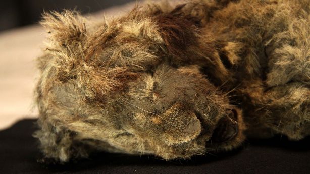
A nearly 28,000-year-old cave lion cub discovered frozen in the Siberian permafrost, is so well preserved, you can still make out each and every one of her whiskers.
A closeup of the head of the female Siberian cave lion cub mummy now known as Sparta.
Researchers in Sweden claim the cub, nicknamed Sparta, is probably the best-preserved Ice Age animal ever uncovered and describe Sparta in Quaternary. Her teeth, skin, and soft tissue have all been mummified by the ice. Even her organs remain intact.
To date, Sparta is the fourth cave lion cub (Panthera spelaea) found buried in the permafrost of Yakutia, which lies in the northeast corner of Russia. She was discovered in 2018 by local resident Boris Berezhnev who was looking for ancient mammoth tusks among the tundra.
As wildlife hunting and trade have become more restricted, ‘tusk hunters’ like Berezhnev have begun to search for ancient ivory in the icy north. With climate change weakening the permafrost and extending the tusk hunting season, we’re finding more ancient remains – and not just from woolly mammoths. In the past few years, residents in Siberia have pulled woolly rhinos, wolves, brown bears, horses, reindeer, and bison out of the permafrost, and some of these carcasses date as far back as 40,000 years.
Clearly, these icy steppes were once home to numerous large mammals. In fact, a year before finding Sparta near the Semyuelyakh River, Berezhnev found another cave lion carcass just 15 meters (49 feet) away. This one, named Boris, showed slightly more damage, possibly from its permafrost cave collapsing, but it was still remarkably intact.
Researchers in Sweden, who have since helped analyze the carcasses, claim both Boris and Sparta are about one to two months old. Yet despite their physical proximity and similar appearances, Boris is thought to be roughly 15,000 years older, give or take a few centuries.
Today, the little we know about cave lions mostly comes from fossils, tracks, and ancient cave art.
Mummified bodies found in permafrost are some of the best evidence we have of their existence. Their frozen carcasses look remarkably similar to modern lions in many ways, just on a much larger scale and with a much warmer coat. But one of the most iconic features of African lions, their mane, seems to be missing on cave lions.
Figure 6 from the Quaternary study: The appearance of the frozen cave lion cub mummies: (a) female Sparta; (b) male Boris. Photos of lion cubs’ heads from the side: (c) Sparta; (d) Boris; (e) Sparta mummy as seen from above; (f) dark brown ‘brush’ of Sparta’s tail.
In fact, early human artwork from the time suggests cave lions rarely sported manes, or if they did, they were extremely discrete. Some Ice Age paintings, for instance, show dark patterns of colouring on the cave lion’s face, but it’s unclear what that represents.
Boris and Sparta are both juvenile cave lions, which means it’s hard to say how their coats would have developed as they aged. Apart from some dark colouring on the backs of their ears, researchers say they are mostly covered in yellowish-brown fur.
If the cubs had a chance to grow up, experts think their fur would probably have turned more of a light grey to help them camouflage in the cold Siberian Arctic.
The presence of a mane is important because it could tell us about the social structures of cave lions. For example, whether they live by themselves or in groups with clear hierarchies.
At the moment, scientists are still debating whether cave lions during the Ice Age roamed the steppes of Siberia on their own or in pride like modern African lions.
There’s one particular painting in France’s Chauvet cave from the Ice Age that depicts nearly a dozen cave lions, both male and female, in the act of hunting bison.
“Hunting in groups can be more effective than solitary hunting when the prey is large, and cave lions would have had many such prey species available in their ecosystem, for example, mammoths and rhinoceros, when there were no other options available to them,” the authors of the recent analysis write.
“In addition, large pride would have helped to protect their kill from the competition and also to protect the cubs and young from predators.”
For now, this is all just guesswork. Even though we have found some astonishingly intact cave lions in recent years, we still don’t have enough information about these extinct predators to reach any conclusions about their social structures.
Perhaps one day, that could change. Maybe we will unearth another cave lion with some hint about their long-lost lives. Or maybe one day, we will successfully bring cave lions back to life.
“There is a very realistic chance to recreate cave lions, and it would be a lot easier than to clone a woolly mammoth,” palaeontologist and one of the study’s authors Albert Protopopov told the Siberian Times.
Some scientists have suggested we do this with woolly mammoths as well, but cave lions are a much younger species. Protopopov suggests that we could supplement their clones with some of the genes from modern African lions, making the work a bit easier. That’s obviously a controversial idea, and the reality of it is probably still a ways off.
For now, the next step is to sequence the entire genome of both Sparta and Boris. Then, we can figure out what to do with the information we collect.
Tragic Loss: 2,500-Year-Old Olive Tree Burned to Ashes in Greek Fires
A 2,500-year-old ancient olive tree on the island of Evia was destroyed today in the ongoing wildfires consuming the region. The ancient tree was located in the olive grove of Rovia and was such an enduring symbol of the landscape that the ancient geographer and philosopher Strabo featured it in his writings.
The tree was large, with a trunk so wide ten people could fit along its diameter. The tree was fertile with olives all the way until it fell victim to the wildfire.
The tragic loss of the Evian tree was posted to Twitter by Apostolis Panagiotou, and the evocative image quickly gained over a thousand likes, with many Greeks leaving responses mourning the impact of the fires.
A historic olive tree on the island of Evia was destroyed by the ongoing wildfires.
The ancient olive tree in Evia is one amongst many losses of the wildfires
The destruction of the treasured tree is just one of many losses experienced by the Greek people in Evia during the course of the wildfires.
In a statement that showcases the desperation and pain of the people of northern Evia, Giannis Kontzias, the mayor of Istiaia – Aidipsos, said that what the people are seeing now is ”the completion of a holocaust.”
”Truth be told, we could have saved much more,” he says. ”I’ve been up on the mountain from Wednesday at 2:30 PM making dramatic calls for more aircraft in the front that we managed to keep back for 30 hours.”
Kontzias described the dramatic turn of events when the wind changed direction and brought the fire to the northwest of Evia.
Evia before the devastation
”The wind turned the fire towards the Municipality of Istiaia Aidipsos, multiplying the fronts,” he explains.
‘”We need more aircraft”
”I’m making a dramatic appeal (to the Greek authorities) to bring aircraft.”
”Very few of them arrived yesterday, but they were inadequate. Today, only seven of them are operating particularly near Artemisio,” the devastated mayor explains.
”One after the other our villages fall. One municipal unit after the other is being destroyed completely. What’s saved has been saved by volunteers and the soul of the residents of this land,” Kontizas noted.
”They remained the last ones to save something from their homes, something from which we’ll be able to hold onto in order to stay and live in this land.”
The day after
“Our children will never see the environment and our land in the same way we saw it,” the mayor stated. The mayor of northern Evia made a grim prediction. He stated that in order for this area of Greece to return to its former status, it will take decades.
”We’ll be struggling for decades to bring northern Evia back to what it used to be,” he says, adding that they owe it to this land to do the best they can.
”The day after will have both financial and environmentally disastrous consequences,” Kontizas notes.
The mayor thanked everybody for their love and assistance and made a pledge for anyone who can assist in any way to do so.
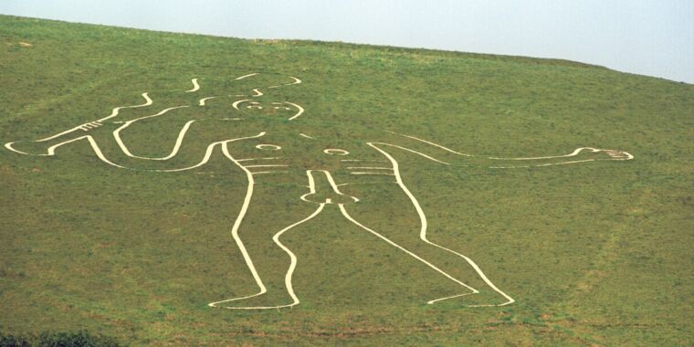
Archaeology breakthrough as ‘flabbergasted’ researchers make Cerne Abbas Giant origin find
Over the centuries the huge, naked, club-wielding giant carved into a steep hillside in Dorset has been thought prehistoric, Celtic, Roman or even a 17th-century lampoon of Oliver Cromwell.
Local lore has that Cerne Abbey was created in 978AD to convert people away from an Anglo-Saxon god.
After 12 months of new, hi-tech sediment analysis, the National Trust has now revealed the probable truth and experts admit they are taken aback. The bizarre, enigmatic Cerne Giant is none of the above, but late Saxon, possibly 10th century.
Martin Papworth, a senior archaeologist at the trust, said he was somewhat “flabbergasted … He’s not prehistoric, he’s not Roman, he’s sort of Saxon, into the medieval period. I was expecting the 17th century.”
The geoarchaeologist Mike Allen, who has been researching microscopic snails in the sediment, agreed. “This is not what was expected,” he said. “Many archaeologists and historians thought he was prehistoric or post-medieval, but not medieval. Everyone was wrong, and that makes these results even more exciting.”
The research has involved studying samples, which show when individual grains of sand in the sediment were last exposed to sunlight. Material from the deepest layer suggests a date range of 700-AD1100.
It was in the middle of that date range, AD978, that Cerne Abbey was founded nearby. Stories talk about the abbey being set up to convert locals away from worshipping an early Anglo-Saxon god called Heil or Heilith, all of which invites the question, is the giant Heilith?
For various reasons, Papworth said that theory did not ring true. The whole story of the giant is made more confusing by there is no mention of the giant in surviving abbey documents. “Why would a rich and famous abbey – just a few yards away – commission, or sanction, a naked man carved in chalk on the hillside?”
Documents from the 16th and 17th centuries also make no reference to the giant, which suggests to Papworth that it was created and then forgotten about, perhaps overgrown with grass until someone noticed the glimmer of an outline.
Gordon Bishop, chair of the Cerne Historical Society, said the conclusions were as intriguing as they were surprising. “What I am personally pleased about is that the results appear to have put an end to the theory that he was created in the 17th century as an insult to Oliver Cromwell. I thought that rather demeaned the giant.”
Bishop said it seemed to him likely the giant had a religious, albeit pagan, significance. “There’s obviously a lot of research for us to do over the next few years.”
More broadly the analysis results shed important light on the phenomenon of chalk hill figures in Britain, said Allen. “Archaeologists have wanted to pigeonhole chalk hill figures into the same period. But carving these figures was not a particular phase – they’re all individual figures, with local significance, each telling us something about that place and time.”
Volunteers rechalking the Cerne Giant’s ribs on 28 August 2019.
At 180ft (55 metres) the Cerne Giant is Britain’s largest, rudest and as a result best-known chalk hill figure. He is also the most mysterious.
Some have said he is Hercules. The more fanciful suggest he was an actual giant slain by villagers as he slept on the hill after a busy day eating their livestock.
Many people doubt that the phallus is original. “If he does date to the time of the abbey then he is more acceptable with trousers on than without,” said Papworth.
Asked for his most likely theory on its origins he admitted he was stumped. “I don’t know. I don’t have one. I can’t get my head around it … you can make up all sorts of stories. I don’t know why he is on the hill, I’ve no idea. I can’t work it out. I never would have guessed he would be the 10th century.”
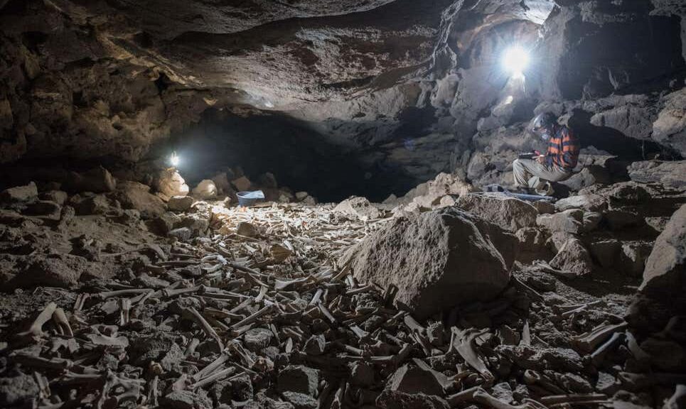
Thousands of human and animal bones hoarded by hyenas in lava tube system, Saudi Arabia
Although hyenas look and hunt like canines, they’re members of the mongoose family and therefore more closely related to a cat. However, just like dogs, hyenas have an affinity for hiding bones — it’s just that they can tend to go a bit overboard.
The Umm Jirsan lava tube in Saudi Arabia.
Case in point, archaeologists were left speechless after they stumbled across a lava tube cavern in northwestern Saudi Arabia that is packed with hundreds of thousands of bones gathered by striped hyenas over the course of 7,000 years.
The ultimate hoarders
The gruesome floor filled with ancient animal bones was found deep in a lava tube system — a network of caverns carved by lava flow. The site, known as Umm Jirsan, was discovered in 2007, but it was only recently that researchers ventured deep into the dark caverns.
Mathew Stewart, a zooarchaeologist at the Max Planck Institute for the Science of Human History in Germany, led a team of researchers who catalogued nearly 2,000 bones and teeth belonging to at least 14 different species, including cattle, horses, camels, rodents, and even humans.
Hundreds of thousands of other bones that are yet to be analyzed still lie on the cavernous floor.
Radiocarbon dating of the samples suggests the animal remains range from 439 to 6,839 years ago, which can only mean these lava tubes had been used as dens for at least 6,000 years.
Images of Saudi Arabia’s Umm Jirsan “hyena cave”: A: Entrance to the western passage and surrounding area. B: Entrance to the western passage. Note the team members on the right-hand wall for scale. C: The back chamber in which the excavation was carried out. D: Plotted sampling square before surface collection and excavation. Credit: Archaeological and Anthropological Sciences.
The striped hyena (Hyaena hyaena) is a bit smaller than spotted and brown hyenas. They have a broad head with dark eyes, a thick muzzle, and large, pointed ears, with a mane of long hair growing along the back.
Their most striking feature is the legs: the front legs are much longer than the hind legs. This gives hyenas their distinctive walk, making them seem like they’re always limping uphill.
Hyenas are nocturnal or crepuscular predators that stay out of sight during the day, preferably in a natural cave or a burrow dug into the hillside. Sometimes they may take over the dens of other creatures where they transport bones to be eaten, fed to the young, or cached for later use.
It’s a well-established fact that hyena dens aren’t tidy at all, being normal to find leftover bones scattered across the floor. However, the lava tube horde stunned even the researchers who were most familiar with the hyenas.
Hyenas will eat an entire human body — except for the skull cap
Although they didn’t find hyenas at the site, the researchers are certain this was one of their dens judging from the cuts, bites, and digestion marks left on the bones.
The presence of human skull fragments was also telling of hyena presence since the animals are known to scavenge through burial grounds in search of food. They normally will consume everything except for the top of the skull.
“The size and composition of the bone accumulation, as well as the presence of hyena skeletal remains and coprolites, suggest that the assemblage was primarily accumulated by striped hyena (Hyaena hyaena),” the authors wrote in a study published in the journal Archaeological and Anthropological Sciences.
Molars and mandibles belonging to wild cows, rabbits, wild goats, camels, and wolves.
It’s highly unlikely that the six skullcaps with gnaw marks on them found at the site belong to humans who were killed by a hyena hunting party.
The mammals are mostly scavengers but when they do hunt they prefer to target hares, birds, and antelopes. However, the possibility that some hunter-gatherers were killed by hyena packs cannot be entirely ruled out.
Today, striped hyenas are a threatened species in Saudia Arabia but thousands of years ago they were common across the Arabian Peninsula.
The current investigation at Umm Jirsan was undertaken as part of the Paleo deserts Project, a large-scale research initiative aimed at tracking environmental and climate change in the Arabian Desert region over the past one million years.
Of particular interest is how human and animal migration in the region waxed and waned with the changing climate. This is a challenging goal since the unforgiving desert climate in the region tends to destroy any exposed organic matter. Luckily, the Umm Jirsan lava tubes create a perfect time capsule that will give scientists material to work with for years to come.
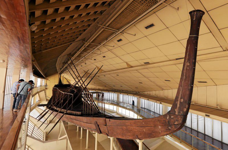
King Khufu’s Boat, an ancient vessel that is the oldest and largest wooden boat discovered in Egypt, has been painstakingly moved from its longstanding home next to the Giza pyramids to a nearby giant museum, officials said on Saturday.
The Solar Boat of Khufu.
The 4,600-year-old vessel, also known as the Solar Boat, was moved to the nearby Grand Egyptian Museum (GEM), due to be inaugurated later this year.
“The aim of the transportation project is to protect and preserve the biggest and oldest organic artefact made of wood in the history of humanity for the future generations,” the tourism and antiquities ministry said in a statement.
It took 48 hours to transport the cedarwood boat, which is 42 metres (138 feet) long and weighs 20 tons, to its new home. It arrived at the GEM in the early hours of Saturday, the ministry said.
The boat was transported as a single piece inside a metal cage carried on a remote-controlled vehicle imported especially for the operation, said Atef Moftah, supervisor general of the GEM project.
It was unearthed in the Great Pyramid in Giza, Greater Cairo, which was itself constructed by King Khufu. This picture shows the Pyramid of Khafre, also in Giza
The vessel, discovered in 1954 at the southern corner of the Great Pyramid, has been exhibited for decades at a museum bearing its name at Giza Plateau.
The Great Boat of King Khufu is more than 4,500 years old and was discovered virtually intact in 1954
Egypt says the Grand Egyptian Museum, which has been under construction intermittently for 17 years, will contain more than 100,000 artefacts when it opens.
Robotic Arms, Solar Winds
The solar boat is not only the oldest but also the largest wooden boat ever discovered in ancient Egypt.
Measuring 42 meters (138 feet) in length, this 20-ton vessel was carved from cedarwood. One of the major concerns for Egyptian authorities, somewhat ironically, was figuring out how to move the ancient vessel.
King Khufu, entombed in the iconic Great Pyramid of Giza
The Egyptian ministry explained in their press release that the primary goal of the transportation project was to “protect and preserve the biggest and oldest organic artefact made of wood in the history of humanity for the future generations.”
It was eventually moved to its new home in Cairo within a secure metal cage, “on a remote-controlled vehicle,” that was custom built for the job in Belgium.
According to the BBC, the Egyptian ministry said the relocation operation began late Friday night and that it took “10 hours” to install the iconic ancient artwork in its new home.
Nothing New Under The Sun?
The Kings of Ancient Egypt were buried within royal burial chambers, and solar boats such as this one were entombed with their ruler and were thought of as functioning, magically-powered devices that were essential for safely transporting that ruler’s soul in the afterlife.
While Egyptian rituals were complex and multi-faceted, changing from one Kingdom to the next, the solar boat represented the fundamental concept that the King “was” the Sun’s actual divine consort on Earth. The cycle of the Sun, therefore, was a highly visible manifestation of the power of the ruler, without which it was feared new plant, animal and human life couldn’t exist.
Carving at the Abydos temple of Pharaoh Seti I, depicting Ra-Horakhty and his sacred solar boat
While this example of a solar boat was commissioned by a Fourth Dynasty monarch who ruled during the Egyptian “Old Kingdom”, the concept of a “Sun vessel” is not unique to that culture. The idea of a “solar barge” or “Sun boat,” carrying the Sun across the sky appears in many polytheistic religions.
And what is perhaps “coolest” about ancient solar boats is that, in a quirk of history which Elon Musk would love, they reflect the modern concept of electrically powered transportation, being powered by clean solar energy.
A New Egyptian Vision
The Grand Egyptian Museum, where the boat is now permanently located alongside many of the ancient king’s artefacts, will be inaugurated later this year after over 17 years in construction.
Planned to contain more than 100,000 artefacts when completed, the GEM, which is located just outside of Cairo on the Giza Plateau, is being hailed as “the new crown jewel of Egypt.”
The Grand Egyptian Museum is due to open by the end of 2021
While the GEM might be a jewel in Egypt’s crown, it also represents the largest and most modern museum experience in the world. Thus, this splendid new structure will hold deep appeal and attract history lovers from all over the planet. When it opens it will, without doubt, become the next “ancient must-see,” and you can learn more about the journey of the GEM, from conception to near completion, here.
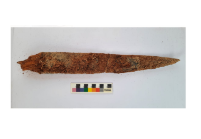
Iron dagger with wooden handle, skeletal remains found at Konthagai, India
The 40-cm-long weapon with a 6-cm-long wooden handle was found at a depth of 77 cm.
The sample will be sent to Beta Analytical Lab, Florida, USA, for exact dating.
An iron dagger with a wooden handle was found inside a burial urn unearthed at Konthagai village, which is part of the Keeladi cluster where the seventh phase of excavation is in full swing to establish the existence of urban civilisation in the Sangam era.
The second season of digging started in February at Konthagai where 25 burial urns have been unearthed so far and 11 of them have been opened, according to R. Kaviya, one of the four Site Archaeology Officers.
These urns measure 95 to 105 cm in height with a circumference of 80 cm. Some of the urns contained iron weapons, shaped like knives, and spears and small terracotta vessels.
The latest, a 40-cm-long iron dagger with a 6-cm-long wooden handle was found at a depth of 77 cm. The urn filled with soil sediment had the five-cm-thick dagger, associated with femur bones, a skull and an offering pot.
It is a type used by warriors belonging to the Sangam period, contemporary to Keeladi dating, according to R. Sivanandam, Director of Keeladi Excavations.
This was the first time that they had stumbled upon a weapon with a wooden handle, and it would be very useful for exact dating of the evidence found so far, he said.
Though extremely fragile, the wooden handle was preserved in rare natural phenomena and collected carefully in foil covers. The sample would be sent to Beta Analytical Lab, Florida, the USA, for an exact dating, added Mr. Sivanandam, who is also the Commissioner (FAC), Department of Archaeology.
25 burial urns have been unearthed so far in Keeladi
The skeleton samples were handed over to experts at Madurai Kamaraj University, where a DNA testing laboratory is coming up.
Ms. Kaviya said the urn was found with a disturbed lid. The broken portion of the lid was retrieved inside the urn at a depth of 80 cm.
There was a possibility that the broken portion of the urn lid fell on the iron dagger, as two urn lid pieces were found on either side of the dagger, which was also damaged.
The Keeladi excavations are being carried out by the Archaeological Survey of India under the supervision of Minister for Industries Thangam Thennarasu and B. Chandramohan, Principal Secretary, Tourism, Culture & Religious Endowments Department.