Archaeologists discover a secret Aztec tunnel built 600 years ago by emperor Moctezuma
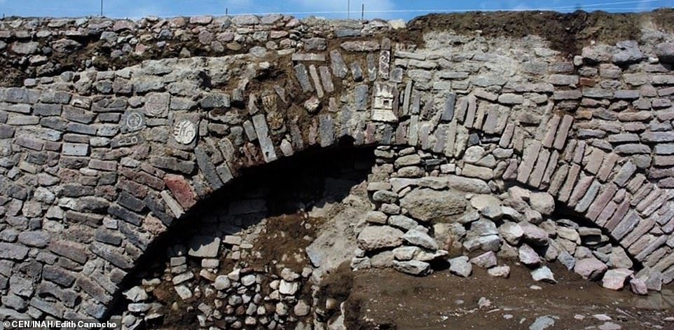
Archaeologists from the National Institute of Anthropology and History (INAH) discovered 11 pre-Hispanic images in a tunnel in Ecatepec, México’s state capital, that is part of a colonial dike system.
Petroglyphs and stucco relief panels were among the photos found on the sides of the 8.4-meter-long tunnel, according to INAH.
The tunnel is part of the Albarradón de Ecatepec, a four-kilometer-long 17th-century dike system.

A war shield, the head of a bird of prey, and a “paper ornament” are among the images carved into the walls of the tunnels while a teocalli, or temple, is etched into the central stone of the arch entrance.
The temple is dedicated to the rain god Tláloc, the INAH archaeologists concluded.
Some of the images are still being studied to determine their exact nature and meaning.
Raúl García, coordinator of a project to preserve the archaeological treasures of the dike system, said that one hypothesis is that the images were made by indigenous people who lived in the pre-Hispanic towns of Ecatepec and Chiconautla. Residents of both towns worked on the construction of the dike, he said.

The archaeologist explained that the tunnel where the images were discovered is in a section of the dike known as the Patio de Diligencias.
The glyphs and stucco panels, all of which have been damaged by hundreds of years of rain, will be covered for protection, García said.
The Albarradón de Ecatepec was declared a historical monument in 2001 and will soon be incorporated into a public park.
México state INAH director Antonio Huitrón said the opening of the park will allow people to enjoy the “cultural heritage to which they are heirs.”
The tunnel where the images were discovered will also be open to the public although the originals won’t be on display.


Huitrón said the stones featuring the petroglyphs and stucco panels will be removed and transferred to the Casa Morelos Community Center in Ecatepec. Stones with replicas of the images will be installed in their place, he explained.
Ecatepec, Mexico’s second most populous municipality, is located just north of Mexico City and is part of the Valley of Mexico metropolitan area.