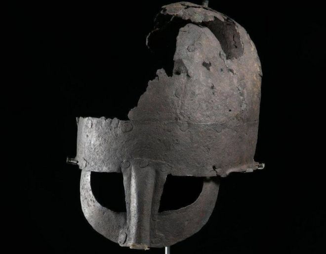
Yarm Viking helmet ‘first’ to be unearthed in Britain
According to new research, a Viking helmet discovered at Teesside is the first ever to be found in Britain. In the 1950s, in Chapel Yard, Yarm, a corroded helmet was unearthed by workmen digging trenches for new sewerage pipes.
The ‘Viking helmet’, as it is known locally, has been on loan to Preston Park Museum from Yarm Town Council for a number of decades. A research project, led by Dr. Chris Caple, has now discovered that the helmet is the first ever found in Britain.
It is also only the second nearly complete Viking helmet found in the world. The unusual artifact has never previously been researched and the age of the helmet had caused much debate.
In recent years, Dr. Caple, Emeritus Reader at Durham University, and his colleagues have discovered new information about the damaged helmet.
They used evidence from recent archaeological discoveries as well as analysis of the metal and corrosion to identifying that it is an Anglo-Scandinavian helmet made in the 10 century in northern England.
Dr. Caple said it was a “challenging project” as the thin iron sheet is now very susceptible to corrosion and has to be kept in very dry conditions.
He said: “Our analysis showed that it was initially preserved in waterlogged conditions, only later becoming damaged and starting to corrode. Fortunately, it was discovered before it corroded away completely.
“Although there are half a dozen early medieval helmets from Britain, the Sutton Hoo, and Coppergate helmets being the most famous, this is the first Anglo-Scandinavian (Viking) helmet from Britain.
“Whilst the Saxon helmets were often highly decorated and were worn by warrior leaders, as many symbols of authority as helmets, by the 10 century we can now envisage that most professional warriors had helmets like the Yarm Helmet.
The helmet is made of iron bands and plates riveted together, with a simple knop at the top
“They were simply manufactured, well designed to protect the wearer (rivets flush with the surface so they did not catch bladed weapons) but no longer decorated.
“Together with a mail hauberk (shirt of chain mail), a helmet was essential personal protective equipment for a warrior. We see almost all the combatants in the 11 century Bayeux Tapestry wearing helmets and hauberks.”
Dr. Caple said that the only other near-complete Viking helmet is from Gjermundbu in Norway.
He said: “They do not normally survive because by the 10th century both Anglo-Scandinavian and Saxons were Christian and no longer buried objects in graves.
“This helmet, like the Coppergate helmet appears to have been hidden in a pit.”
Alan Gallafant, Chairman of Yarm Town Council, said: “Yarm Town Council are delighted that the provenance of this important historic helmet has been confirmed, thanks to the work carried out by Dr. Chris Caple and Durham University.
“Yarm Town Council welcomes the launch of this exciting development on Yarm’s history.”
The Yarm Helmet has been on permanent display at Preston Park Museum since 2012, where its condition is closely monitored and it continues to be one of the star objects on display.
The helmet has been on loan to Preston Park Museum from Yarm Town Council
Councillor Jim Beall, Stockton-on-Tees Borough Council’s Cabinet Member for Health, Leisure, and Culture, added: “It’s very exciting to have confirmation that the Yarm Helmet on display at Preston Park Museum is a very rare example of a Viking helmet and the first to be found in Britain.
“The museum is open to the public once again and it is great to welcome visitors to see this fascinating piece of history.”
30,000-Year-Old Bosnian Pyramids Built With Man-Made Cement
New reports that independent analysis from five separate Institutes of materials confirms that the Bosnian Pyramids contain high quality man-made concrete construction material eliminating all skeptical claims about the authenticity of the Bosnian Pyramids.
The controversial site of the Bosnian Pyramid of the Sun has a team of over 200 interdisciplinary scientists from all over the world doing scientific analysis on not only the nature and age of the building materials, but also determining how the energy of the pyramid was used by the ancient scientists for applications beneficial to humanity ranging from geothermal transportation, climatology, and advancements in human physiology and health.
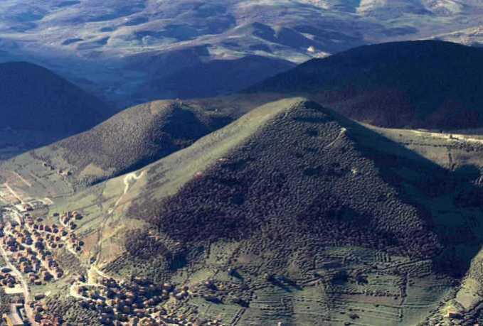
Bosnian Pyramid of the Sun, the biggest stone structure in the shape of the pyramid on the Planet with a height of 220 meters, Visoko, Bosnia-Herzegovina.
Results released by the Polytechnic University of Turin, Italy of chemical and diffractometry laboratory analysis done on sandstone and conglomerate blocks taken from the Bosnian Pyramid of the Sun show that the samples are an inert material with a binding, similar to that found in ancient Roman concrete. These results were confirmed by analysis of the samples done at the University of Zenica, Bosnia-Herzegovina.
In a separate independent test, Professor Joseph Davidovits, renowned French Scientist, member of the International Association of Egyptologists, and author confirms this claim. “I performed electron microscopic analysis of the sample and I propose the geopolymer chemistry that was used to make this is ancient concrete,” wrote Prof Davidovits.
He further adds that the sample is composed of “a calcium/potassium-based geopolymer cement and that although he cannot date the sample, he can discern that it is not modern concrete, but more like the technique used by the Egyptians 3,500 years ago.” In his book, The Pyramids: An Enigma Solved, Davidovits presents the current knowledge of pyramid construction that is supported by scientific, historical, and linguistic studies which prove that the Egyptian pyramids were constructed using agglomerated stone (limestone cast like concrete).
The research on pyramid technology has long suspected that pyramid energy involves science and machinery far more advanced than what we currently have today. Christopher Dunn, author of The Giza Power Plant, published in 1996 explains that the pyramids were ancient energy machines, currently a popular theory among researchers. The pyramids of Bosnia have the same elements described in the Giza pyramids that define the structure of an ancient power generator system.
After visiting Bosnia in 2011, Chris Dunn stated, “While I was in Visoko, experts from various disciplines showed excitement on the result of their studies of the so-called pyramid hill. Hopefully, in due course, clear signs of ancient precision engineering will eventually be discovered.”Now in 2013, the Bosnian archaeological site is further excavated and new scientific evidence has emerged proving that ancient precision engineering was indeed used to build the Bosnian Pyramids.
Bosnian Pyramid of the Moon, with its the height of 190 meters second biggest stone structure in the Bosnian Valley of the Pyramids. Together with the Sun and Dragon pyramids form a perfect equilateral triangle. All pyramids have been covered by soil and vegetation similar to pyramids in Central America and China.
Since it was discovered in 2005 by Dr. Sam Semir Osmanagich Ph.D., director of Center for Anthropology and Archaeology at the American University in Bosnia-Herzegovina, the Bosnian Pyramid complex has been stonewalled by mainstream archaeologists until recently scientific evidence which makes it impossible to deny the authenticity of this history-changing discovery.
“The team of interdisciplinary scientists conducting studies on the cosmic energy enigma at the archaeological site in Bosnia are on a relentless pursuit to uncover the wisdom from the ancient culture that left this behind,” states Dr. Sam Osmanagich. “There are facts about a physical phenomenon that can be scientifically verified, yet there remain many unanswered questions unexplainable using our current recorded history.”
Facts that have been verified by scientific analytic testing include:
· The Sun pyramid stands over 722 feet (220 m) high one third taller than the Great Pyramid of Giza
· Radiocarbon dating shows the pyramid to be at least 24,800 years old
· Material Analysis shows that the structure is from man-made concrete
· There is an 8.000 kg ceramic block under the pyramid in the underground labyrinth
· An energy beam, electromagnetic in nature with a radius of 4.5 meters and a frequency of 28 kHz, has been detected and measured coming from the top of the Sun pyramid
· An ultrasound beam with a radius of 10 meters and frequency of 28-33 kHz has been measured on the top of the pyramid, as well
· The pyramids are aligned with the earth’s cardinal points and oriented to stellar North
“Although tens of thousands of pyramids have been discovered across the planet, none have the construction quality and date back as far as the ones in Bosnia,” states Osmanagich. “Bosnia is the original pyramid, the oldest and largest ever constructed. It has an exact zero degree North orientation and is potentially the key to releasing information about ancient technology that can free the world of its dependence on fossil fuel along with offering the possibility of finding astounding medical breakthroughs in the scientific community.”
Massive 1,100 Year Old Maya Site Discovered In Georgia’s Mountains?
The Mayans built astonishing temples in Mexico, Guatemala, and Honduras – but now some believe the ancient peoples fled their dissolving civilization and ended up in Georgia.
Historian and architect Richard Thornton believes a 1,100-year-old archaeological site shows that Mayan refugees fled Central America and ended up in the North Georgian mountains near Blairsville.
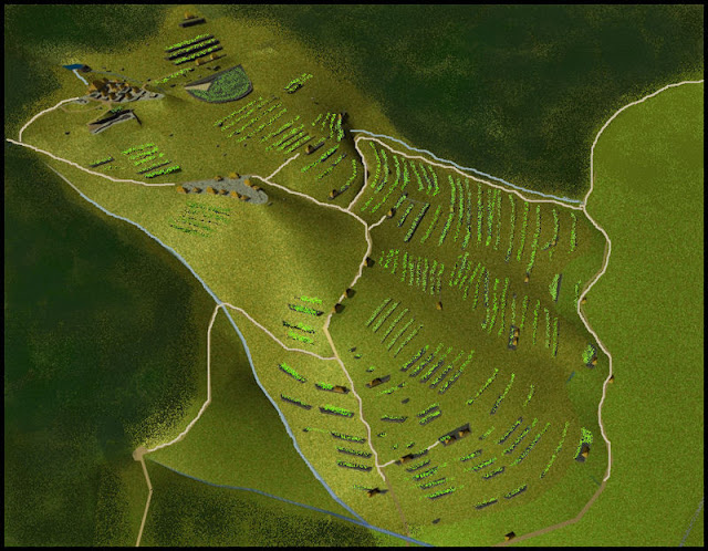
His astonishing theory is based on the discovery of 300 to 500 rock terraces and mounds on the side of Brasstown Bald mountain that date to 900AD – around the time the Mayans began to die out.
City Spotting: This 3D virtual reality image was made from the ruins found in the Brasstown Bald mountain
Mr. Thornton’s blockbuster theory revolves around the area near Brasstown Bald potentially being the ‘fabled city of Yupaha, which Spanish explorer Hernando de Soto failed to find in 1540’.
He described it as ‘certainly one of the most important archaeological discoveries in recent times’.
The Mayans died out around 900AD for reasons still debated by scholars – although drought, overpopulation, and war are the most popular theories, reported the Atlanta Journal-Constitution.
The remains were first found by retired engineer Carey Waldrip when he went walking in the area in the 1990s. Archaeologist Johannes Loubser excavated part of the site and wrote a report about it in 2010, but does not believe the rock terraces are Mayan.
‘I think that (Mr. Thornton) selectively presents the evidence,’ Mr. Loubser told the Atlanta Journal-Constitution. ‘But he’s a better marketer than I and other archaeologists are.’
Look at this: The remains were first found by retired engineer Carey Waldrip, pictured, when he went walking in the area in the 1990s
Mr. Loubser, who excavated a rock wall and small mound, added that claims like this must be backed up with ‘hard evidence’ because of the various conflicting opinions in the archaeological world.’
Mr. Loubser believes the structures could have been built by the Cherokee Indians or an earlier tribe between 800AD and 1100AD.
He stopped digging because he realized the site could be a grave. Still, Mr. Thornton claims early maps of the location named two villages ‘Itsate’, which was how Itza Mayans described themselves.
The terrace structures and date helped him reach his conclusion. It was commonplace for the Itza Maya to sculpt a hill into a pentagonal mound,’ he argues. ‘There are dozens of such structures in Central America.’
But not everyone is impressed by Mr. Thornton’s theory. He cited the University of Georgia archaeology professor Mark Williams in an article on Examiner.com.
‘I am the archaeologist Mark Williams mentioned in this article,’ Professor Williams said on Facebook. ‘This is total and complete bunk. There is no evidence of Maya in Georgia. Move along now.’
Theory: The Mayans could have left Central America and ended up in the North Georgian mountains
Fascinating: The Mayans died out around 900AD for reasons still debated by scholars – although drought, overpopulation and war are the most popular theories (file picture)
‘The sites are certainly those of Native Americans of prehistoric Georgia,’ Professor Williams told ABC News. ‘Wild theories are not new, but the web simply spreads them faster than ever.’
Mr. Thornton wasn’t bothered by the ensuing debate, in fact, that’s exactly what he wanted.
‘I’m not an archaeologist. I’m a big picture man,’ said Mr. Thorton to the Atlanta Journal-Constitution.
‘We’re hoping this article stirs up some interest. I was just trying to get the archaeologists to work some more on the site and they come back snapping like mad dogs.’
He works with a company called History Revealed Media that helps create three-dimensional maps of excavated sites and said that when he compared his map of the Georgia site, it reminded him of other Mayan works.
‘It’s identical to sites in Belize,’ he argued.
The Mayans have been under intense scrutiny over the past few years as rumors abound about their mysterious 5,132-year calendar allegedly predicting the apocalypse on December 21, 2019.
But various experts have spoken out against Doomsday, including Mexico’s ‘Grand Warlock’ Antonio Vazquez, to say that the Mayan calendar instead will just reset and a new time-span will begin.
Found: Another 3D virtual reality image of the lost Mayan city of Yupaha, according to Richard Thornton, left, and a relief sculpture of a warrior at the Mayan ruins in Uxmal, right
A 2,200-year-old inscription discovered in Southern India
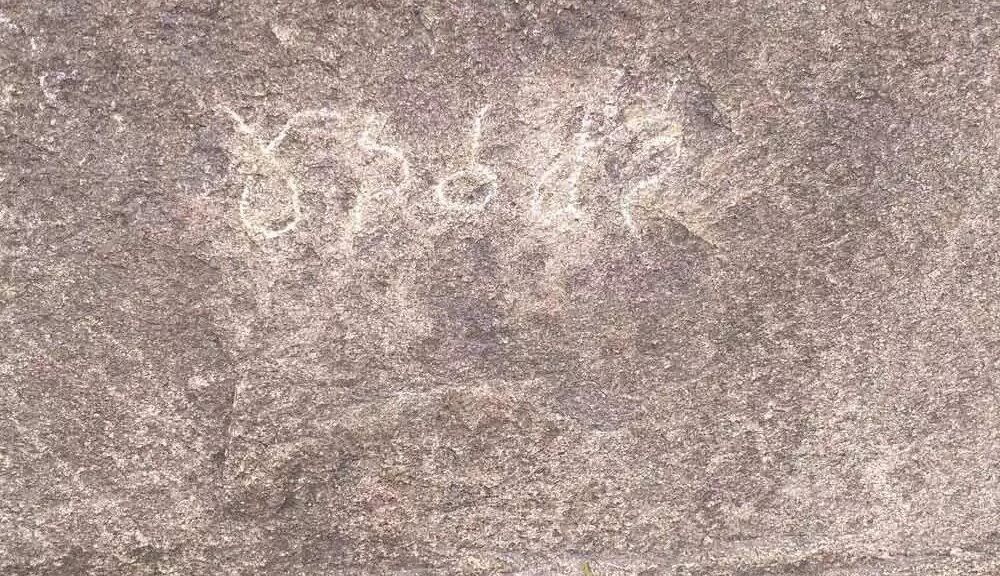
In unveiling the forgotten but glorious history of India’s Telangana state which was a part of Asmaka Mahajanapada, the predecessor to an Empire, researchers found an inscription on a rock in Maltumeda village in Nagireddipet Mandal in Kamareddy district written in Ashokan Brahmi script from the 2nd century BC.
This is believed to be older than Dulikatta, Kotilingala, and other inscriptions, which belong to 1st century AD.
A team, comprising MA Srinivasan, a research scholar from Osmania University working on Buddhist archaeology in Telangana, Y Bhanu Murthy, former chief caretaker, Telangana Heritage Department, and B Shankar Reddy, an avid enthusiast of archaeology and surveyor by profession, discovered a label inscription (minor inscription) consisting of five letters in Brahmi script and Prakrit, the language of that period in the village.
Researchers found an inscription written in Ashokan Brahmi script of 2nd century BC on a rock in Maltummeda village of Nagireddipet mandal in Kamareddy district.
The inscription, ‘Madhavachanda’, is on a big boulder on a small hillock on the south of the village, around 500 meters away from the Manjeera river. It was read and certified by the Director, Epigraphy, at the Archeological Survey of India (ASI) in Mysore confirming that the latest finding could be the earliest inscription in Telangana to date.
Another significant aspect is that this strengthens the significance of archaeological sites like Bodhan and Kondapur, which are on the Manjeera-Godavari valley, through which the genesis and growth of the Satavahana Empire can be traced.
Mid-Godavari – The cradle of Telangana’s civilization
“Telangana is a part of Asmaka Mahajanapada that spread from north to south of Telangana, with mid-Godavari as its core area.
We have recorded evidence that kingdoms and civilizations flourished in those times from Asmaka Mahajanapada,” Srinivasan told ‘Telangana Today’. He pointed that no one bothered about the antiquity of Telangana after its merger with Andhra Pradesh and for decades, the concentration was more on Amaravati and Andhra Pradesh.
Rewriting of the Telangana history started only during the last one or two decades. Many researchers wrote about many areas and a lot of evidence was brought out, he added.
The team, which was scouting for early historic sites of ancient Telangana in the Manjeera valley, came to know that there were rock paintings in Maltummeda.
“This confirmed that there were habitations since the Neolithic period in that area. We hoped that we might find evidence of the Satavahana period such as bricks,” he said.
“Shankar Reddy found the rock inscription and informed us. We cleaned it suspecting that someone in the recent past may have made that carving on the rock.
We realized that there were five letters. We took the photographs and sent it to the ASI in Mysore and they confirmed that it was a 2nd century BC inscription,” Y Bhanu Murthy added. The team of enthusiasts frequently visited another site in Demikalam, 10 km from Maltummeda, where there is a cave temple.
What is more significant is that the ASI in Mysore has confirmed that the inscription was 2nd century Brahmi, Ashokan Brahmi to be more specific.
This is Brahmi of Ashoka times and the style is similar to that of rock carvings of Ashoka times. “We don’t understand much of what the inscription is trying to convey. Is Madhavachanda a name of a person or a location? Which religion did he belong to? Or is he saying it is my hillock? We don’t know, we must also search literary text to understand the context of Madhavachanda.
Definitely, it was the early Satavahana period. Satavahanas ruled between 220 BC and 225 AD for nearly 445 years.
The team members said the ASI must take care of the site to protect and estampage the inscriptions to make a replica of it to preserve and publish it. They hoped that the ASI would build a shed or fencing to protect the inscription from direct contact of visitors.
Textile treasure trove shows Importance of fashion to Ancient Britons
Notable archeological evidence from the site of a prehistoric settlement in the eastern part of England, suggests that Bronze Age Britons had a liking for high-end fashion. Excavations, 30 miles north-west of Cambridge, have unearthed the earliest examples of superfine textiles ever found in Britain. They are also among the most finely-made Bronze Age fabrics ever discovered in Europe as a whole – and are of huge international significance.
Detail of preserved Bronze Age textile made from plant fibres
Up to now, researchers from the University of Cambridge have found more than 100 fragments of textile unspun processed fibre and textile yarn at the site. Some of the yarn is of superfine quality – with some threads being just 100 microns (1/10 of a millimetre) in diameter, while some of the fabrics themselves are so finely woven that they have 28 threads per centimetre, fine even by modern standards. It’s likely that some of the fragments of textile are from items of clothing.
Originally, some of the textiles must have been of very substantial size – because they had been folded, in some cases in up to 10 layers. If made to be worn, these folded fabrics may well have been large garments, potentially, capes, cloaks – or even large drapes, perhaps similar to those known from elsewhere in the ancient (and sometimes modern) worlds – the ancient Greek chiton, the Roman toga and the Indian sari. A drape folded into 10 layers for temporary storage would have served as a substantial garment – potentially up to 3 metres square (i.e. 9 square metre).
Most of the superfine fabrics from the site – Must Farm near Whittlesea, Cambridgeshire – were made of linen. When the village was flourishing around 3,000 years ago, textile manufacture seems to have been a key craft practiced there. Hundreds – possibly thousands – of flax seeds have so far been found on the site (some of which had been stored in containers). Flax is the crop that produces the fibres used in linen production.
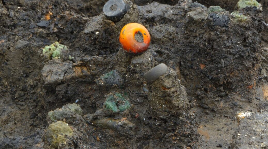
Amber bead and others found in situ
What’s more, the presence on the site of unspun processed fibre, yarn, and finished textiles all strongly suggests that the village was involved not only in using textiles but also in manufacturing them. Timber fragments with delicate carpentry, found during the Historic-England-funded excavation may well be the remains of looms. Indeed fired clay loom weights have been unearthed there.
The archaeologists have also discovered that Bronze Age Britons also had a penchant for a different type of fabric – made of processed nettle stems (from a locally available non-stinging subspecies of nettle – today known as fen nettles). Unlike flax, nettles grew wild and therefore did not need to be cultivated. What’s more, well-made nettle textile was often particularly fine and silky.
But nettles may well have had additional benefits – at least in the eyes of the users of the fabrics.
In traditional ancient folklore, nettles of various types were often regarded as having magical powers. They were seen as being able to protect both humans and animals from sorcery and witchcraft. What’s more, garments made of nettles were therefore sometimes seen as protecting their wearers from evil. Indeed one of Europe’s most famous folktales – the Wild Swans (written by Hans Christian Andersen, but thought to be based on traditional folk stories) – reveals how shirts, made of nettle yarn, enabled their wearers to break a witch’s spell.
So far no evidence of any extensive patterns or coloured dyes have been found on any of the linen and nettle yarn textile fragments – although the edge of one piece of fabric (perhaps part of a shawl or cape) seems to have been decorated with fringes, rows of knots, and strips featuring different styles of weave. Certainly, dying the linen would have presented substantial technical difficulties – but bleaching it would have been much less challenging. It is therefore very likely that the naturally light brown linen was bleached to achieve a creamy white or possibly even dazzlingly pure white appearance. Basic bleaching of the fabric might well have been achieved with the use of a mixture of urine and milk or by simply laying out the fabrics on wet grass on a succession of sunny days. The village appears to have been very prosperous, yet tragically short-lived.
As well as making (and presumably using) ultra-fine fabrics, at least some of the inhabitants wore exotic jewellery made of blue, black, yellow and green glass manufactured in the eastern Mediterranean region – probably in what is now the Syria or Turkey.
They lived in large well-built houses and had a wide range of tools and other possessions. So far, around 50 bronze axes, sickles, spears, swords, razors, hammers, tweezers, and awls have been found along with some 60 wooden buckets, platters, and troughs as well as around 60 well preserved ceramic bowls, mugs and storage jars. Dug-out canoes and two wooden wheels have also been unearthed.
But the archaeological evidence suggests that this thriving and prosperous settlement was probably attacked, burnt, and destroyed by its enemies less than a year after it was built.
In the five houses excavated so far, the population seems to have fled or been captured or killed, leaving all their possessions behind – meals half eaten, salted or dried meat still hanging in the rafters, garments neatly folded on or around well-made wooden furniture.
“It’s a bit like discovering the Marie Celeste. Everything is exactly as it was left. Only the inhabitants are missing,” said the director of the excavation, Mark Knight of the Cambridge Archaeological Unit.
“This site is providing the modern world with an image of daily life in the British Bronze Age that was until now beyond our dreams. It is only the very specific and unusual circumstances of the destruction of the settlement that has, paradoxically, allowed so much of it to be preserved intact,” he said.
Because the village had been set alight, large numbers of wooden, textile and other artefacts were charred – and because the houses were built on wooden stilts in a river (flanked by marchland), everything ultimately ended up underwater, where it was subsequently covered with silt and mud.
This rare combination of charring and waterlogging and natural burial under sediment has been responsible for the extraordinarily high levels of preservation.
Most of the artefacts have been found inside the settlement’s houses. So far, five of these large 6-8 metre diameter structures have been found at the site. Again, because of charring and subsequent waterlogging, around half of all the wall, roof and other timbers from these buildings have been preserved.
The excavation is being directed by archaeologist Mark Knight of the Cambridge Archaeological Unit, with textile research being carried out by a textile specialist, Dr Susanna Harris of the University of Glasgow. Because of its national and international importance, the entire project is being funded to the tune of £1.4 million by Historic England and the owner of the site, one of the UK’s major brick-making companies – Forterra.
The finds include the largest group of prehistoric textiles ever discovered in Britain – and the largest collection of complete bronze, wooden and ceramic artefacts ever found in a British Bronze Age settlement.
Oldest evidence of life on land found in 3.48 billion-year-old Australian rocks
Whether you are looking at an actual fossil or crinkles in the rock itself can be hard to tell in the search for the earliest life on earth. The discovery of 3.5 billion – year – old fossils in the Australian desert in the 1980s has long shadowed these doubts Now, scientists think they ended up putting the matter to bed
The Dresser formation in the Pilbara Craton contains evidence of ancient hot spring activity.
In ancient fossilized microbe formations called stromatolites, found in the Dresser Formation fossil site of the Pilbara region, researchers have finally detected traces of organic matter.
“This is an exciting discovery – for the first time, we’re able to show the world that these stromatolites are definitive evidence for the earliest life on Earth,” said geologist Raphael Baumgartner of the University of New South Wales (UNSW) in Australia.
You may remember the time scientists claimed to have found 3.7 billion-year-old fossils in Greenland. Later research determined that these fossils were just plain old rocks, and the crown was returned to the Pilbara fossils.
But, although everyone was pretty sure the Pilbara fossils were the real deal, it hadn’t actually been conclusively proven. They had the shape and structure of microbial stromatolites, but no evidence of organic matter to back it up.
There’s more riding on this than a tiara and a sash reading “Oldest fossils.” It’s deeply relevant to one of the fundamental questions about our very existence: When and how did life develop on this sloshy blue marble?
So, Baumgartner and his team went digging. Not literally, though; they analyzed previously drilled core samples from deep underground, below where the rocks could have been affected by the weather. This means these samples were much better preserved than those from the surface; in their paper, the team said the preservation was “exceptional”.
Spherical bubbles preserved in 3.48 billion-year-old rocks in the Dresser Formation in the Pilbara Craton in Western Australia provide evidence for early life having lived in ancient hot springs on land.
Microbial evidence from Dresser formation hot spring
The researchers analyzed the samples in thin slices using multiple techniques, including scanning electron microscopy and scanning transmission electron microscopy; energy-dispersive X-ray spectroscopy, and Raman spectroscopy; nano-scale secondary ion mass spectrometry; and stable carbon isotope analysis.
If that seems like overkill, well, it’s not really. If one of those lines of inquiry showed a positive result and the rest didn’t, it would mean much shakier ground for drawing a conclusion. But things looked good across the board.
The team’s analyses revealed that the stromatolites are predominantly made up of a mineral called pyrite, riddled with nanoscopic pores. And in the pyrite are inclusions of nitrogen-bearing organic material, as well as strands and filaments of organic matter that closely resemble the remnants of biofilms formed by microbe colonies.
“The organic matter that we found preserved within pyrite of the stromatolites is exciting – we’re looking at exceptionally preserved coherent filaments and strands that are typically remains of microbial biofilms,” Baumgartner said.
“I was pretty surprised – we never expected to find this level of evidence before I started this project.”
Previously, a different team of UNSW researchers found evidence of 3.48 billion-year-old microbes in hot spring deposits in the Pilbara.
An Australian Geographic segment on Karijini National Park.
Two hikers gaze at the rock formations in Dales Gorge at Karijini National Park in Pilbara, western Australia.
Because those deposits are about the same age as the crust of Mars, it’s thought that they could tell us how to find potential fossils on Mars – especially since there’s evidence the Red Planet once had hot springs too.
Indeed, NASA has been investigating the Pilbara to try to learn the possible geological signatures that could indicate the presence of stromatolites.
“Understanding where life could have emerged is really important in order to understand our ancestry,” Baumgartner said. “And from there, it could help us understand where else life could have occurred – for example, where it was kick-started on other planets.”
Serbian Roman Artifact Vanishes 24 Hours After Discovery
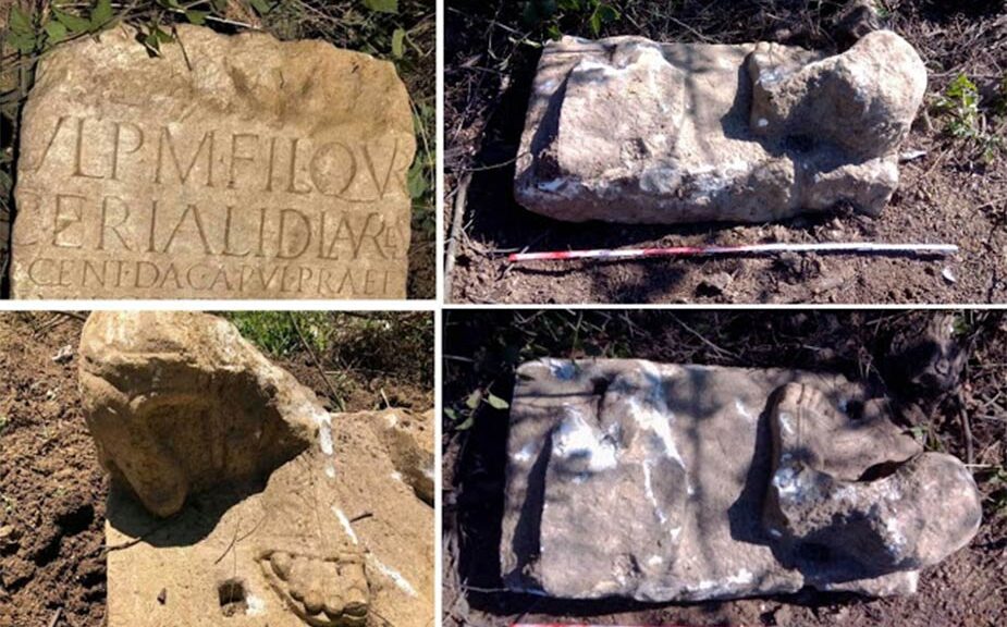
A just recently excavated ancient Serbian Roman artifact, a stone piece covered with etched Latin text, has actually been taken just 24 hours after it was found. The unusual Roman artifact was found on July 10, 2020, throughout roadway building works resulting in the Vinča landfill site.
Side of the stolen Serbian Roman artifact showing the Roman inscription.
According to a report on Archaeology News Network among the roadway, employees notified the National Museum in Belgrade about the amazing finding, nevertheless, when a museum archaeologist got to the site the next early morning the Serbian Roman artifact had actually disappeared without a trace.
Serbian Roman Artifact and The Lost Life Of A Roman Authorities
The museum archaeologists understood the Serbian Roman artifact belonged to a marble monolith dating to the second-century which one side on the artifact portrayed 2 feet using shoes that belonged to a previous sculpture.
The opposite, nevertheless, was engraved with 15 lines of Latin text explaining in information the life and times of a high-ranking Roman military authority who, according to the National Museum in Belgrade, “led various military detachments against the Dacians and served in three legions.”
The majority of the contemporary state of Serbia belonged to the Roman Empire for about 600 years, from the first century BC up until the arrival of the Slavs in the Balkans throughout the sixth-century.
This ancient monolith might have been a substantial addition to the recognized ancient history of Serbia since it likewise supplied brand-new proof about a war in the location of Singidunum or ancient Belgrade.
Stolen Artifact an Example of Daring, Swift Archaeological Theft
Prior to the stone piece inexplicably vanished the museum personnel had actually notified the landfill management group that due to its size and weight the stone was going to be raised by a crane and thoroughly moved to the National Museum in Belgrade.
A museum representative stated in a news release that historical items found in the area of the Republic of Serbia “belong to the Republic of Serbia by law.” And they likewise stated the “epigraphic monument” had actually been formally taped which an administrative treatment had actually been actioned to recover and restore it.
And this implies that the event is being dealt with as a case of “aggravated theft” and criminal charges have actually been raised versus the unidentified lawbreaker( s).
How in the world, in 2020, can such a logistically complex outdoor criminal activity happen and be successful? I imply it’s not like the artifact was a golden ring or a silver bracelet that a solo lawbreaker might simply conceal in their pocket.
To have actually moved such a large stone, a whole group of males with heavy building devices would have been needed. And this is more than likely precisely what occurred: a criminal gang more than likely settled the best individuals at the site, handled to get the things into a truck, and after that rapidly vanished to offer the stone to the greatest bidder on the dark side.
However as bad as this all noises, it worsens, since this kind of daytime break-in is prevalent in Serbia.
Side of the stolen Serbian Roman artifact showing the sandal-covered feet in the upper right.
Serbia: An Area With Excessive Unguarded Treasure
A 2016 paper ” Historical Break-ins of Antiques in Serbia” released by a group of researchers from the Institute of Archaeology, Belgrade, Serbia, specifies that the area of Serbia is a target for historical crooks since it has actually been house to lots of particular cultures throughout the past: “from European prehistory, Roman civilization, Byzantine and Serbian Medieval art up to the present day.”
What this implies is that Serbia has countless “unguarded” historical sites and middle ages abbeys representing the nation’s “material, cultural and spiritual past.” And with the majority of sites being mainly unguarded, it is not unexpected that criminal gangs tear the landscape apart in Serbia.
However, contributing to the large weight of untouched sites is the issue of simply how important even the tiniest Serbian artifacts can be.
An example of an unlawful historical excavation in Serbia was the discovery of the “Golden Avar Belt Buckle,” which was found with a metal detector at a depth of about 2 meters in the town of Divoš, near Sremska Mitrovica (Sirmium). This single palm-sized things was approximated to be worth “around one million euros.”
Thankfully when it comes to the taken belt buckle,” МUP RS “, the Serbian department for combating the mob, detained the primary criminal and his accomplices, who were all charged with a 3 year suspended sentence for contravening the unlawful trade act, which restricts unapproved historical excavations. Ideally, the just recently taken stone Roman artifact and those who took it will quickly be discovered.
Pits of Skulls Found in Shimao: China’s Neolithic City of Mystery
The villagers of China’s dusty Loess Plateau believed for decades that the crumbling rocks near their homes were from China’s Great Wall, which was very common along the area.
As large numbers of jade pieces shaped into disks, blades and scepters were found by locals and looters, suspicions grew as jade was only available at about 1000 miles away from the area and wasn’t even a feature of the Great Wall.
When a team of Chinese archaeologists came to investigate the rubbles, they started unearthing the area and found that the stones weren’t a part of the Great Wall but were the ruins of a magnificent fortress city.
5: jade items found at East Gate; 7: jade and metal bracelets with a human arm bone found in a burial; 8: stone human head; 9: Shimao ceramics.
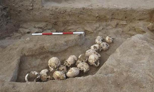
The digging had revealed a 230 feet high pyramid surrounded by more than six miles of protective walls and an inner sanctum containing jade artifacts, painted murals, and gruesome evidence of human sacrifice.
Before the excavations were suspended earlier this year due to the coronavirus pandemic, the archaeologists had dug up 70 stunning stone sculptures which were figurines of monsters, serpents, and half-human beasts resembling Bronze Age iconography of China.
Block carved with humanoid deity. Southern retaining wall, upper citadel, Shimao, Shenmu county, Shaanxi province, China.
The site has been named Shimao (original name undetermined) and carbon dating of its parts date back to around 4,300 years ago i.e. 2,000 years before the oldest section of the Great Wall. As it seems, Shimao flourished for nearly half a millennium in that remote region, and then suddenly, it disappeared.
Aerial photo of Shimao’s East Gate. A: U-shaped screen; B: gate tower; C: L-shaped wall; D: bastion; E: corner tower.
Shimao now is the largest known Neolithic settlement in China and none of the ancient Chinese texts mentions a city residing so far north of the “cradle of Chinese Civilization”. It had an expanse of 1000 acre and is larger than the Central Park of New York City. Its art and technology had influenced the northern regions and the future dynasties of China.
Along with other discoveries at prehistoric sites, Shimao is forcing historians to rethink the origin of the Chinese civilization.
According to the leader of the dig at Shimao, “Shimao is one of the most important archaeological discoveries of this century.”
Shimao’s step pyramid.
Designed for danger, Shimao was built on a conflict zone i.e. a borderland dominated by warfare between farmers of the central plains and herdsmen of the northern steppe. To protect themselves from violent attacks, the Shimao people constructed their 20-tiered pyramid on the highest of the northern hills.
It’s visible from every part of the city and is half the height of the Great Pyramid at Giza in Egypt built around the same time. Its base, however, is four times larger and the Shimao elites resided at the topmost tier of the pyramid which had a 20-acre palatial complex with amenities.
The pyramid was surrounded by embryonic urban designs and inner and outer perimeter walls. More than 70 small satellite stone towns have also been discovered in the Shimao orbit.
The defense system of civilization is as fascinating as its infrastructure and huge fortifications. However, the most terrible discovery was from underneath the city’s eastern wall which had 80 human skulls clustered in six pits without the skeletons that represent traditions of human sacrifice in this astonishing prehistoric town.