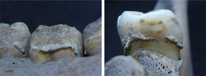
Category Archives: WORLD

Armchair archaeologists are discovering ancient historic sites during the lockdown

Armchair archaeologists are discovering ancient historic sites during the lockdown

Volunteer archaeologists working from home are revealing hitherto uncharted prehistoric burial mounds,  Roman roads, and medieval farms, using LiDAR technology. This just goes to show what can be achieved working from home during a pandemic, history in the making. Businesses and companies have all had to make changes during this time, meaning that software has been updated and implemented across the board, including updating communication areas for workers to have access to, meaning that shares in software such as Slack (Slack Aktie kaufen) have gone up for the benefit of home workers.

A probable Iron Age or Roman enclosed settlement (red arrows) and associated field system (blue arrows) revealed by LiDAR data but hidden today beneath woodland.

An innovative project is underway integrating scientific research with the power of the public. Led by Dr. Smart and Dr. João Fonte from the University of Exeter, and working closely with Cornwall and Devon Historic Environment Record, citizens were called on to search databases of aerial images while on coronavirus lockdown and they revealed “roads, burial mounds, and settlements – all while working from home,” according to a report in the Heritagedaily.

These topographical images of the Tamar valley, that highlight hidden features and with historic maps of the area, have been cross-referenced by amateur archaeologists. Lead researchers Dr. Chris Smart also said that they “draw the archeological map of the South West’ to get a clearer understanding of the history of the regions over thousands of years.

A section of a probable Roman road. The road’s ‘agger’ – the raised metalled surface – shows as a straight pale line (red arrows). A line of quarry pits show as black spots (blue arrows) possibly used to gather material for the road

The sites were not released because of the possibility that treasure hunters could enter the sites prior to being properly given access, but they are all in the Tamar Valley. The team found parts of two Roman roads with about 30 large, prehistoric or Roman settlement enclosures, about 20 prehistoric burial mounds, as well as the remains of hundreds of medieval farms, field systems, and quarries. 

Those leading the project believe they will make many more discoveries in the coming weeks as more images are reviewed – potentially hundreds of new sites. The team, led by Dr. Smart from the University of Exeter, are analyzing images from technology used to create detailed topographical maps by the Environment Agency.

Modern vegetation and buildings can be removed from the data, allowing archaeologists to look at the shape of the land surface to find the remains of archaeological earthworks.  

‘The South West arguably has the most comprehensive LiDAR data yet available in the UK and we are using this to map as much of the historic environment as possible,’ said Dr. Smart. They are focusing on the Tamar Valley but are also looking at the land around Bodmin Moor, Dartmoor, Plymouth, and Barnstaple – an area covering 1,500 sq miles. 

The information has helped researchers to realize the region was much more densely populated during the Iron Age than previously thought.  They haven’t been selective in the images they have asked volunteers to look at either, so to find so many from a relatively random record is even more exciting. The research is adding to an evolving database of all known heritage in the South West of England and includes everything from lost field boundaries to prehistoric enclosures and everything in between. 

‘Ordinarily, we would now be out in the field surveying archaeological sites with groups of volunteers, or preparing for our community excavations, but this is all now on hold,’ said Smart. 

‘I knew there would be enthusiasm within our volunteer group to continue working during lockdown – one even suggested temporarily rebranding our project “Lockdown Landscapes”,’ he said.

‘I don’t think they realized how many new discoveries they would make.’

New archaeological sites are often found by chance, through digs before new development, so it is unusual to find so many in one go. Dr Smart said there is a large gap in the historical map of the South West, as there isn’t as much development there as in other parts of the country – so these chance discoveries don’t happen as often.  Most of the finds so far have been Iron Age enclosed settlements but they have found dozens of sites dating back to prehistory and as late as the Medieval era. 

One regular project volunteer, Fran Sperring, said: ‘Searching for previously unknown archaeological sites – and helping to identify places for possible future study – has been not only gratifying but engrossing.

‘Although it’s a fairly steep learning curve for me – being a relative novice to the subject – I’m enjoying every minute. Archaeology from the warm, dry comfort of your living room – what could be better?’

Dr. Smart is working closely with his University of Exeter colleague Dr. João Fonte, a specialist in LiDAR data manipulation and interpretation.

A probable Iron Age or Roman enclosed settlement, defined by a bank and ditch (red arrows). The remnants of the bank shows as a pale line on the LiDAR data, and the ditch as a darker line 

‘Remote sensing is a very powerful tool for archaeological prospection,’ said Fonte.

‘Whilst I normally work in Northwest Iberia, I’m really happy to collaborate in this project and share my expertise for the benefit of Devon and Cornwall’s wonderful landscapes,’ he added.  The team is also working with Cornwall and Devon Historic Environment Record teams to find a way to integrate all of this new information into their databases. It’s hoped the work can then be rolled out over more of the South West of England. When the worst of the pandemic is over the team intends to undertake geophysical surveys at a number of the newly-identified sites as part of the Understanding Landscapes project.

Dr. Smart said ‘It’s hard for us not to be able to carry out the work we had planned this summer – including an excavation at Calstock Roman fort.

‘Hopefully, this is only a temporary blip and we will be back out in the countryside with volunteers as soon as it is safe to do so.’

There is a wider benefit to using the LiDAR mapping data though. Dr. Smart hopes to be able to create a wider-reaching citizen science project that will help map more of the region’s history and create a rich record for the future. He said they were able to make use of existing maps created from a number of aerial surveys and satellite data.  These maps are generated by the Environment Agency for the purpose of flood monitoring, but Dr. Smart said the detail is also perfect for spotting historical sites.

Norway’s melting ice is revealing priceless ancient artifacts

Norway’s melting ice is revealing priceless ancient artifacts

“The moment these artifacts melt out of the ice, they’re immediately vulnerable to the elements,” says James H, in an interview with national geographic.

Ancient artifacts preserved in snow and ice over thousands of years in Norway’s mountains are emerging at an unprecedented rate, and archaeologists are scrambling to collect them all before it’s too late, according to national geographic

Because ice patches in the past have contracted and expanded due to temperature shifts, many of the objects recovered have likely one time or another been exposed and then buried by snow and ice.

An iron arrowhead, possibly dating back a millennium or more, emerging from an ice patch in the mountains of Norway.

The bronze arrowheads of 1500 years ago, the Tunic of the Iron Age, and even the remains of a wooden ski complete with leather binding left behind sometime in the year 700. Some of the oldest objects were dropped more than 6,000 years ago.

With low-winter precipitation and warmer summers the alpine ice dramatically reducing the alpine ice that acts as a time capsule for lost treasures.

“The ice is a time machine,” Lars Pilö, an archaeologist who works for the Oppland County council told Archaeology in 2013. “When you’re really lucky, the artifacts are exposed for the first time since they were lost.”

A ski with leather binding recovered from an ice patch in the Norwegian mountains. Analysis later determined that the artifact dates back to the year 700.

Unlike glaciers, which tend to crush and grind objects as they move down a mountain, the majority of artifacts coming out of Norway are being recovered from ice patches.

These isolated non-moving accumulations of ice and snow are significant to the archeological record because of their extreme stability, with many containing layers of seasonal snowpack dating back thousands of years.

Sections of ice in the Juvfonne snow patch in Jotunheimen, Norway, are an astounding 7,600 years old, according to a 2017 study.

An Iron Age tunic recovered from the Lendbreen ice patch in August 2011.

Despite their remote setting and scarce visits from modern-day humans, ice patches for thousands of years were veritable hot spots for ancient hunters.

In the summer, reindeer herds often crowd together on the islands of snow and ice to escape pesky, biting botflies, which have a strong aversion to the cooler temperatures. In the past, hunters would follow, losing or forgetting precious equipment along the way that was later buried and preserved in the winter snows.

Some items, such as the 1,600-year-old knife shown in the video below, look as if they were lost only a few decades ago.

A small iron knife with a birchwood handle was found just below the pass area at Lendbreen. It has been radiocarbon-dated to the 11th century.

Because ice patches in the past have contracted and expanded due to temperature shifts, many of the objects recovered have likely one time or another been exposed and then reburied by snow and ice. They also have a tendency to be carried by meltwater. As explained on the Secrets of the Ice Facebook page, the 2,600-year-old arrows shown in the image below were washed downslope far from the place they were originally lost.

Arrows discovered in the scree of an ice patch were later determined to date back to 600 B.C.

Some of the most exciting finds are those objects found emerging from the surface of the ice, a sign that they have previously been untouched by melting, according to researchers from the Oppland County Council. These artifacts are generally exceptionally preserved, with organic materials such as leather and fabric still present. It’s also an indication of the severity of anthropogenic global warming, with certain ice patches in Norway estimated to have retreated to levels last seen during the Stone Age.

“It’s very impressive when you can say this melting ice is 5,000 years old, and this is the only moment in the last 7,000 years that the ice has been retreating,” Albert Hafner, an archaeologist at the University of Bernsays Hafner, told Archaeology. “Ice is the most emotional way to show climate change.”

The preserved remains of a 3400-year-old hide shoe discovered on an ice patch in 2006. Over the last 30 years, some 2,000 artifacts have been recovered from Norway’s melting ice fields.

Unfortunately for archaeologists, the rate of ice loss coupled with the extremely small annual windows of opportunity to scour the alpine patches, means some newly exposed items will break down and disappear before anyone has a chance to study them.

“This material is like the library of Alexandria. It is incredibly valuable and it’s on fire now,” George Hambrecht, an anthropologist at the University of Maryland, College Park, told New Scientist.

Right now you might be thinking, “I want to help find and preserve these incredible artifacts!,” and we agree, it sounds like quite the adventure to take a romp into the Norwegian wilderness and possibly stumble upon a well-preserved Viking Sword (see below). The reality, however, is that field work can sometimes be laborious and uncomfortable, with every day at the mercy of Mother Nature’s fickle moods.

That said, the Oppland County Council did accept volunteers last spring and it’s possible, especially with so many finds emerging from the ice each year, that others may be called upon to assist.

“We may not find much (or we could strike the jackpot, who knows),” Lars Pilø wrote last April in the Secrets blog. “It all depends on the melting conditions, and they develop over the summer and during fieldwork. If we are unlucky, the scenery and the team spirit make up for the lack of finds.”

A Viking sword discovered in 2017 and dating back to c. AD 850-950.

Scientists find evidence of fires built in Yucatán cave 10,000 years ago

Scientists find evidence of fires built in Yucatán cave 10,000 years ago

In Mexico the oldest traces of charcoal ever discovered is found in a cenote of the Yucatán Peninsula.

Recent archeological evidence from tests of burnt charcoal has shown that the first inhabitants on the Yucatán peninsula in Mexico constructed bonfires in the cave now flooded with water for over 10,000 years.

Chemical charred samples of 14 prehistory bonfires were obtained by the scientists of the National Autonomous University of Mexico (UNAM) in 2017 and 2018 from the cenote of Aktun Ha (sinkhole) at a distance of around nine kilometers from Tulum, Quintana Roo.

In late April this year archaeologist Luis Alberto Martos López authored an article about the charcoal sample analysis which was published in the journal  Geoarchaeology detailing how they had all been found in the Ancestors Chamber of the Aktun Ha cenote.

The subsequent study included controlled heating experiments, nuclear magnetic resonance spectroscopy, and carbon dating to determine the fires had burned between “10,250 and 10,750 years ago.”

Studies show that bonfires in the Aktun Ha cenote were created by a man more than 10,000 years ago.

Located beside the Tulum-Cobá highway the cenote is known locally as the “Car Wash,” for before becoming a major heritage and tourist attraction taxi drivers used to get water for washing their cars.

The dating of the fires corresponds to the early Holocene period, which is the geological epoch we are still in that began more than 11,000 years ago at the end of the last Ice Age, and the 14 charcoal remnants have been called the “oldest ever discovered in a Yucatán Peninsula cenote” according to a report in Mexico News Daily.

Mr. Martos López said this finding is helping him and his fellow scientists to reconstruct the history of fire in the Americas which he believes is of great importance for the “study of evolution and human migration.”

Before this discovery was cemented as bonafide archaeology the scientists first had to negate the possibility that waters from elsewhere had swept the charcoal remains into the cenote cave.

And increasing this possibility, in 2018, the discovery of an underground link between the Sac Actun underwater river system which is approximately 263 kilometers long, and the Dos Ojos system in Tulum which is 84 kilometers long, which Geo Mexico called “the world’s largest underwater cave system .” However, the archaeologists were able to determine that the fires had been burned locally to the cenote.

Studies show that bonfires in the Aktun Ha cenote were created by a man more than 10,000 years ago. Octavio del Río in front of the main bonfire.

Analysis of the charcoal revealed the fires had reached temperatures as high as 600 C and archaeological divers discovered stone tools and artifacts in the cave, such as hammers and scraper tools, suggesting it was a temporary shelter where butchery and cooking occurred.

But the researchers say the early hunter-gatherers who lived on the Yucatán Peninsula may have used the Ancestors Chamber “for ritual purposes”.

Describing how the ancient sacred site was accessed over 10 millennia ago, Martos explained that to get into the cave in prehistoric times people would have had to crawl through “a narrow five-meter-long tunnel whose entrance was hidden by a mound of rocks.”

At the end of the tunnel, the Ancestors Chamber of the Aktun Ha cenote measures 20 square meters high and five to six meters wide, and around 10,000 years ago a natural well-formed at the back of the cave and Martos explained that before it was flooded with water it had been “well ventilated allowing the fire smoke to escape.”

Inhabitants of the Chamber of Ancestors of the Aktun Ha cenote. 

This new discovery jigsaw into the content of a Feb 2020 news article I wrote for Archaeology org about new research published in the journal  PLOS One detailing the discovery of “a 9,900-year-old human skeleton,” found in the Chan Hol cave, near the Tulum archaeological site in Quintana Roo.

Belonging to a woman who had died in her 30s, the archaeologists referred to her as being among the “first people to set foot in the Americas.”

In context, when this 9,000-year-old woman sat around a fire at night considering where she might have come from, her fire burning ancestors who left the charcoal behind in the Aktun Ha cenote were as distant to her as the Norman Invasion of Britain in 1066 AD is to us, having occurred almost 1,000 before our present day.

It seems that as technologies rapidly advance, every few months archaeologists in Mexico push back the anthological clock penetrating deeper into our Ancient Origins, and very soon we may have an answer to the big question: where did the 10,000-year-old fire starters come from?

Ancient Bones Found in Bulgarian Cave Are Oldest Evidence of Modern Humans in Europe

Ancient Bones Found in Bulgarian Cave Are Oldest Evidence of Modern Humans in Europe

According to new research, modern humans have overlapped with Neanderthals in Europe longer than previously thought. Remains of Homo sapiens found in a Bulgarian cave are roughly 44,000 to 46,000 years old, making them the oldest directly dated remains of modern humans in Europe, reports Bruce Bower for Science News.

Nicola Davis for the Guardian reports that Neanderthals had been stumpy, cold-adapted hominins living across Europe and as far east as Siberia until about 40 000 years ago.

Neanderthal remains to live on in modern human DNA, indicating that our species and theirs met and interbred, but how long the two groups overlapped is unclear.

Excavations at the Bacho Kiro Cave in Bulgaria uncovered ancient human bones along with stone tools, animal bones, bone tools, and pendants.

Other human remains previously discovered in the United Kingdom and Italy have been dated to between 41,000 and 45,000 years ago, but their ages were measured indirectly, relying on the fossils’ archaeological and geological surroundings rather than the specimens themselves, reported Jonathon Amos for BBC News in 2011.

The direct dating of these newly unearthed remains from the Bacho Kiro Cave in northern Bulgaria comes from two sources: radiocarbon dating and DNA extracted from a tooth and six shards of bone identified as belonging to H. sapiens.

Both methods dated the remains to around 44,000 to 46,000 years ago, the researchers report in two papers published in the journals Nature Ecology & Evolution and Nature.

“Our work in Bacho Kiro shows there is a time overlap of maybe 8,000 years between the arrival of the first wave of modern humans in eastern Europe and the final extinction of Neanderthals in the far west of Europe,” Jean-Jacques Hublin, a paleoanthropologist at the Max Planck Institute and co-author of the research, tells the Guardian.

The new estimate adds as much as 5,000 years of biological, cultural, and behavioral interaction between the species compared to the chronology suggested by other researchers, he tells the Guardian.

Hublin and his colleagues began their new excavation at the Bacho Kiro Cave in 2015. The site was first excavated by archaeologists in 1938 and then again in the 1970s.  The new dig turned up animal bones, tools made of stone and bone, beads and pendants, and, of course, a handful of ancient human remains.

The team had some 1,200 fragments of bones and teeth, but only a single molar could be visually identified as having come from a modern human. To figure out which species all the other fragments belonged to, the researchers extracted proteins from each specimen.

The protein’s structure can be used to tell species apart. This massive screening process yielded six additional chunks of human remains. Genetic evidence also corroborated the identities of six out of the seven fossils.

“In my view, this is the oldest and strongest published evidence for a very early upper paleolithic presence of Homo sapiens in Europe, several millennia before the Neanderthals disappeared,” Chris Stringer, an expert in human origins from London’s Natural History Museum, tells the Guardian.

In 2019, Stringer was part of a team that reported an incomplete skull found in Greece may have belonged to a modern human that lived some 210,000 years ago. However, both the age and species assigned to the skull have been disputed.

Initial Upper Paleolithic artifacts, including blades and a sandstone bead, from the Bacho Kiro Cave in Bulgaria.

The tools and ornaments found alongside modern humans remain at Bacho Kiro, such as pendants made of cave bear teeth, closely resemble artifacts from Neanderthal sites in western Europe dated several thousand years later, Hublin tells Science News.

The similarities provide “evidence that pioneer groups of Homo sapiens brought new behaviors into Europe and interacted with local Neandertals,” Hublin adds.

Stringer tells the Guardian that he has doubts about whether subsequent Neanderthal jewelry and tools were influenced as a result of interactions with early modern humans. In an interview with Science News, Stringer cites Neanderthal jewelry made out of eagle talons from roughly 130,000 years ago.

The new findings highlight the mystery of why Neanderthals disappeared when they did, if, as these new findings suggest, they coexisted with modern humans for millennia. If they were able to persist side by side for so long, what finally drove Neanderthals to extinction?

According to Richard Klein, a paleoanthropologist at Stanford University who was not involved in the research, who spoke with Tom Metcalfe of NBC News, “that’s the ultimate question.”

Stringer tells the Guardian that there simply may not have been enough of these early modern human pioneers in Europe to establish and sustain a significant presence, adding that an unstable climate could have also kept them at bay.

Historic Weapon Unearthed in Croatia

A valuable piece of Croatian warrior heritage found at Krka National Park

LOZOVAC, CROATIA— Archaeology Org reports that an artillery weapon was found in a defensive wall in a tower at the fourteenth-century site of Nečven fortress, which is located in southern Croatia’s Krka National Park.

The bronze object, known as a mačkula, is similar to a mortar and was used to attack fortified settlements. This one is thought to date to the seventeenth or eighteenth century. 

“A mačkula is a weapon that holds a special place in Croatian warrior heritage. During the traditional manifestation Sinjska Alka, every hit „u sridu“ (‘in the middle’) is celebrated by a shot from the mačkula.

Its value is enhanced even more during the ceremony for the winner when several mačkula are shooting from Sinj’s old fortified walls,” Krka NP said in a statement.

The mačkula was found in the defensive wall of the hexagonal tower right from the entrance of the fortress.

Archaeological research of Nečven fortress started back n 2011 and along with archaeological excavations conservation works of the fortress was also carried out. Metal and stone findings were conserved at the Krka NP conservation workshop.

“The mačkula is another valuable finding that will complete the Krka NP archaeological collection and contribute to the valorization of the cultural and historical heritage of our region,“ Nella Slavica, director of the Public Institute of Krka National Park said.

Slavica says that the conservation of the Nečven fortress is a long-lasting project to preserve heritage along with preparatory activities for the future construction of a 462-meter pedestrian suspension bridge over the Krka River connecting Nečven and Trošenj fortresses.

The bridge which will connect the fortresses

The bridge will be a tourist attraction with its fascinating views of the Krka canyon and Nečven and Trošenj Fortresses without causing any burden on the underlying phenomenon.

“Built at the beginning of the 14th century, the Nečven fortress is one of the most valuable monuments of medieval fortification architecture in Dalmatia. It was owned by the Nelipić family for two centuries.

In the 16th century, Nečven was conquered by the Ottomans but a year before the final expulsion of the Ottomans and the liberation of the City of Knin in 1688, Skradin inhabitants took over Nečven fortress and from it guarded the border.

Opposite Nečven fortress above the Krka canyon, the Trošenj fortress has proudly stood for centuries. Both fortresses represent valuable monuments of Croatian cultural heritage.

Nečven and Trošenj fortresses, built and owned by great Croatian families Nelipići and Šubići as part of the medieval defense system, today are valued within Krka National Park,” Krka NP stated.

Over 40 Ancient Ships Discovered on the Bottom of the Black Sea

Over 40 Ancient Ships Discovered on the Bottom of the Black Sea

A group of maritime archeologists studying sea levels in the Black Sea have uncovered over 40 shipwrecks as a “complete bonus.”

The shipwrecks provide new data on the maritime interconnectivity of the Black Sea.

Scientists have discovered a rare collection of over 40 shipwrecks in the Black Sea, including those from the Ottoman and Byzantine Empires, which provide insight into the ways of life and seafaring that stretch back into prehistory.

Researchers from the University of Southampton in the UK were surveying the Bulgarian waters of the Black Sea, where areas of land were inundated as the water level rose following the last Ice Age.

Members of the expedition mapping submerged ancient landscapes, the first of its kind in the Black Sea, discovered and inspected the shipwrecks, many of which provide the first views of ship types known from historical sources, but never seen before.

The wrecks, which include those from the Ottoman and Byzantine Empires, provide new data on the maritime interconnectivity of the Black Sea coastal communities and manifest ways of life and seafaring that stretch back into prehistory.

“We’re endeavoring to answer some hotly-debated questions about when the water level rose, how rapidly it did so and what effects it had on human populations living along this stretch of the Bulgarian coast of the Black Sea,” said Jon Adams, Principle Investigator on the Black Sea Maritime Archaeology Project (Black Sea MAP).

“As such, the primary focus of this project is to carry out geophysical surveys to detect former land surfaces buried below the current sea bed, take core samples and characterize and date them, and create a palaeoenvironmental reconstruction of Black Sea prehistory,” said Adams, Founding Director of the University of Southampton’s Centre for Maritime Archaeology.

Based on board the Stril Explorer, an off-shore vessel equipped with some of the most advanced underwater survey systems in the world, researchers are surveying the sea bed using two Remotely Operated Vehicles (ROVs).

“The wrecks are a complete bonus, but a fascinating discovery, found during the course of our extensive geophysical surveys,” said Adams.

“They are astonishingly preserved due to the anoxic conditions (absence of oxygen) of the Black Sea below 150 meters,” he said.

Photogrammetric model of a Byzantine period wreck.

“Using the latest 3D recording technique for underwater structures, we’ve been able to capture some astonishing images without disturbing the sea bed,” Adams said.

1,600-Year-Old Elongated Skull with Stone-Encrusted Teeth Found in Mexico Ruins

1,600-Year-Old Elongated Skull with Stone-Encrusted Teeth Found in Mexico Ruins

The 1600-year-old skeleton of an upper-class woman whose skull was purposely deformed and teeth encrusted with mineral stones was found by archeologists near ancient Teotihuacan ruins of Mexico.

Archeologists who found the 1,600-year-old skeleton near Mexico’s ancient Teotihuacan said the woman was 35-40 when she died with intentionally deformed skull and teeth encrusted with mineral stones

When she died, between the ages of 35 and 40, the woman was buried with 19 jars that served as offerings, the National Anthropology and History Institute said.

The institute said in a statement that her cranium had been elongated by being compressed in a “very extreme” manner, a technique commonly used in the southern part of Mesoamerica, not the central region where she was found.

Her teeth contained two round pyrite stones, which were encrusted in her top front teeth.

This was a practice that was used among the nobility in Maya regions in southern Mexico and Central America. 

The Maya are credited with being the masters of cosmetic dentistry as they were known to decorate teeth by embedding them with precious stones or by carving notches and grooves into them.

Tiny holes were chipped out of teeth and ornamental stones—including jade—were attached with an adhesive made out of natural resins, such as plant sap, which was mixed with other chemicals and crushed bones.

The dentists likely had a sophisticated knowledge of tooth anatomy because they knew how to drill into teeth without hitting the pulp inside.

Gold studded teeth, Pre-Columbian Ecuador.

Last year, archaeologists discovered liquid mercury in a subterranean tunnel beneath the Temple of the Feathered Serpent in Teotihuacan, which may represent an underworld river that leads the way to a Royal tomb or tombs.

The remains of the kings of Teotihuacan, some of the most powerful rulers of the pre-Hispanic world, have never been found.

Such a discovery would be monumental as it would unravel many of the mysteries surrounding this ancient civilization.

The enigmatic pre-Hispanic city of Teotihuacan, some 50 kilometers (30 miles) north of Mexico City, thrived between the first and eighth centuries, after which its civilization vanished.

Its two majestic Sun and Moon pyramids are major tourist attractions.

The 1,600-year-old skeleton of an upper-class woman found near Mexico’s ancient Teotihuacan wore a prosthetic lower tooth made of a green stone known as serpentine

The remains were believed to be Richard III

Archaeologists found a skeleton under a car park in the city of Leicester. The remains were believed to be Richard III

Experts from the University of Leicester said DNA from the bones matched that of descendants of the monarch’s family. Lead archaeologist Richard Buckley, from the University of Leicester, told a press conference to applause: “Beyond reasonable doubt it’s Richard.”

The earliest surviving portrait of Richard III in Leicester Cathedral. Archaeologists are hoping to find his grave under a council car park in Leicester.

Richard, killed in battle in 1485, will be reinterred in Leicester Cathedral. Mr. Buckley said the bones had been subjected to “rigorous academic study” and had been carbon-dated to a period from 1455-1540.

Dr. Jo Appleby, an osteo-archaeologist from the university’s School of Archaeology and Ancient History, revealed the bones were of a man in his late 20s or early 30s. Richard was 32 when he died. His skeleton had suffered 10 injuries, including eight to the skull, at around the time of death. Two of the skull wounds were potentially fatal.

One was a “slice” removing a flap of bone, the other was caused by a bladed weapon that went through and hit the opposite side of the skull – a depth of more than 10cm (4ins).

‘Humiliation injuries’

Dr Appleby said: “Both of these injuries would have caused an almost instant loss of consciousness and death would have followed quickly afterwards.

“In the case of the larger wound, if the blade had penetrated 7cm into the brain, which we cannot determine from the bones, death would have been instantaneous.”

Other wounds included slashes or stabs to the face and the side of the head. There was also evidence of “humiliation” injuries, including a pelvic wound likely to have been caused by an upward thrust of a weapon, through the buttock. Richard III was portrayed as deformed by some Tudor historians and indeed the skeleton’s spine is badly curved, a condition known as scoliosis.

However, there was no trace of a withered arm or other abnormalities described in the more extreme characterisations of the king.

Missing princes

Without the scoliosis, which experts believe developed during teenage years, he would have been about 5ft 8ins (1.7m) tall, but the curvature would have made him appear “considerably” shorter.

Dr Appleby said: “The analysis of the skeleton proved that it was an adult male but was an unusually slender, almost feminine, build for a man.

“Taken as a whole, the skeletal evidence provides a highly convincing case for identification as Richard III.”

Richard was a royal prince until the death of his brother Edward IV in 1483. Appointed as protector of his nephew, Edward V, Richard instead assumed the reins of power. Edward and his brother Richard, known as the Princes in the Tower, disappeared soon after. Rumors circulated they had been murdered on the orders of their uncle.

Challenged by Henry Tudor, Richard was killed at Bosworth in 1485 after only two years on the throne.

DNA trail

He was given a hurried burial beneath the church of Greyfriars in the center of Leicester. Mr. Buckley said the grave was clumsily cut, with sloping sides and too short for the body, forcing the head forward.

“There was no evidence of a coffin or shroud which would have left the bones in a more compact position.

“Unusually, the arms are crossed and this could be an indication the body was buried with the wrists still tied,” he added. Greyfriars church was demolished during the Reformation in the 16th Century and over the following centuries, its exact location was forgotten.

However, a team of enthusiasts and historians managed to trace the likely area – and, crucially, after painstaking genealogical research, they found a 17th-generation descendant of Richard’s sister with whose DNA they could compare any remains. Joy Ibsen, from Canada, died several years ago but her son, Michael, who now works in London, provided a sample.

The researchers were fortunate as, while the DNA they were looking for was in all Joy Ibsen’s offspring, it is only handed down through the female line and her only daughter has no children. The line was about to stop.

Tomb plans

But the University of Leicester’s experts had other problems. Dr. Turi King, project geneticist, said there had been concern DNA in the bones would be too degraded: “The question was could we get a sample of DNA to work with, and I am extremely pleased to tell you that we could.”

She added: “There is a DNA match between the maternal DNA of the descendants of the family of Richard III and the skeletal remains we found at the Greyfriars dig.

“In short, the DNA evidence points to these being the remains of Richard III.” In August 2012, excavation began in a city council car park – the only open space remaining in the likely area – which quickly identified buildings connected to the church. The bones were found in the first days of the dig and were eventually excavated under forensic conditions.

The spot (circled in red) where archaeologists found the remains of the 15th century monarch
The final resting place of Richard III? A body matching his description was found here buried in a shroud

Details of the reburial ceremony have yet to be released, but Philippa Langley from the Richard III Society said plans for a tomb were well advanced. She said of the discovery of Richard’s skeleton: “I’m totally thrilled, I’m overwhelmed, to be honest, it’s been a long hard journey. I mean today as we stand it’s been nearly four years.

“It’s the culmination of a lot of hard work. I think, as someone said to me earlier, it’s just the end of the beginning.

“We’re going to completely reassess Richard III, we’re going to completely look at all the sources again, and hopefully there’s going to be a new beginning for Richard as well.”