Scientists discover remains of Hobbit humans that stood only 3ft high and lived 700,000 years ago in Indonesia
SCIENTISTS have discovered the fossils of a “hobbit” that lived 700,000 years ago on an Indonesian island.
A scientist’s estimation of what the “hobbits” might have looked like
The homo floresienis were ancient humans that lived between 100,000 and 50,000 years ago.
Adults stood just three-and-a-half feet tall and their brains were roughly one-third the size of our own, about the size of a chimpanzee’s.
Because of their miniature size, researchers nicknamed the unusual findings Hobbits.
The discovery consists of just six tiny teeth and a fragment of a small lower jawbone, but researchers say it is enough to suggest the fossils belonged to a direct ancestor of the Hobbits.
One theory states the Hobbits may have arrived on the island from Java after being washed out to sea by a tsunami.
The fossils included some tiny teeth.
As well as a piece of the lower jawbone
Over time, they could have shrunk on their new island home – a strange yet common phenomenon known as island dwarfism.
This relies on a variety of factors, from limited food sources to a lack of predators to defend themselves against.
Other researchers believe the fossils belonged to anatomically modern humans who suffered from some type of disorder that led to extreme disorder.
Microcephaly and Down syndrome have both been proposed.
However, the new discovery suggests otherwise – hobbits who wound up on the island seemed to defy traditional evolution and growth.
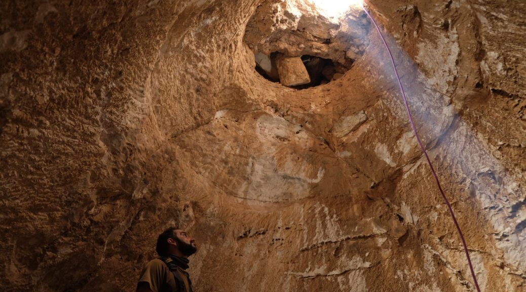
Luxurious 1,200-year-old mansion found in southern Israel
Between two mosques in Rahat, archaeologists uncover an opulent home with a finished basement that likely belonged to a wealthy landowner in the early Islamic Period
Luxury can be found in unexpected places. Archaeologists announced Tuesday the discovery of a 1,200-year-old estate in Israel’s southern Negev desert, boasting unique underground structures that allowed its owners to overcome the searing summer heat.
In a statement on the discovery, the Israel Antiquities Authority said the sprawling property may have been the residence of a wealthy landowner overseeing farmsteads in the area.
It was discovered during excavations conducted ahead of the expansion of the Bedouin city of Rahat, just north of Beersheba.
Archaeologists said the mansion, dated to the early Islamic Period in the 8th or 9th century CE, had four wings and was erected around the main courtyard. Finely coloured frescoes adorned the walls and floor in one of the wings, they said, while other rooms featured very large ovens, likely used for cooking.
The most surprising discovery, however, was made under the courtyard – a three-meter-deep cistern dug into the rock that provided the residents with cool water throughout the year, and adjoining vaulted structures.
Workers are seen on a 1,200-year-old rural estate, discovered during excavations by the Israel Antiquities Authority during the expansion of the town of Rahat.
Aerial view of the rural estate uncovered in Rahat, with the vaulted complex in the centre.
The archaeologists directing the IAA excavation, Oren Shmueli, Elena Kogan-Zehavi and Noé D. Michael, said that the subterranean vaulted structures were used to store foodstuffs, and enabled the residents to move around freely underground without having to emerge into the punishing sun.
“The luxurious estate and the unique impressive underground vaults are evidence of the owners’ means,” the archaeologists said in the statement.
The water cistern.
“Their high status and wealth allowed them to build a luxurious mansion that served as a residence and for entertaining; we can study the construction methods and architectural styles, as well as learn about daily life in the Negev at the beginning of Islamic rule,” they said.
Eli Eskosido, the director of the IAA, touted the archaeologists’ cooperation with the local community in Rahat, among whom he said the discovery was generating “interest and excitement.”
The estate, he added, “was uncovered in an area located between two ancient mosques, perhaps among the earliest ever discovered.
The Israel Antiquities Authority and the Authority for the Development and Settlement of the Bedouin are planning together to conserve and exhibit the finds to the general public.”
The IAA said that on Thursday the site would be open to the public for free public tours, including family digging and sieving activities.
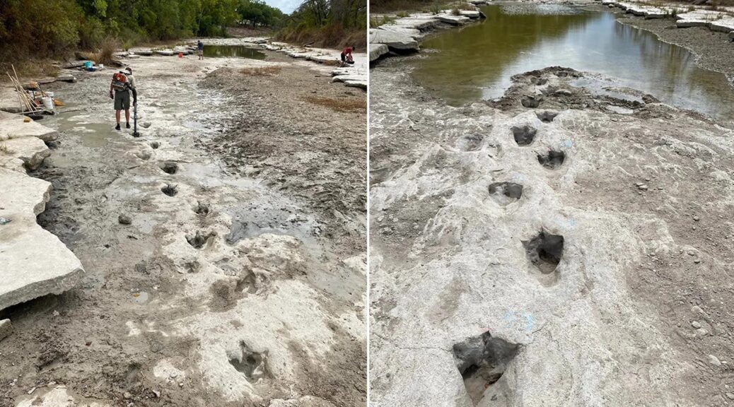
Dinosaur tracks revealed in Texas as severe drought dries up the river
Dinosaur Valley State Park in Texas has unearthed an exciting discovery after extreme drought conditions dried up a river – giant dinosaur footprints that date back to 113 million years ago.
The tracks were uncovered in the Paluxy River as its water level receded due to the major drought that has parched parts of northern Texas this summer, the park announced last week. The park is located near Glen Rose, southwest of Dallas.
“Due to the excessive drought conditions this past summer, the river dried up completely in most locations, allowing for more tracks to be uncovered here in the park,” the Texas Parks and Wildlife Department told Fox News Digital on Tuesday.
“Under normal river conditions, these newer tracks are underwater and are commonly filled in with sediment, making them buried and not as visible.”
Most dinosaur tracks at the park belong to two different species: a theropod called Acrocanthosaurus and a sauropod called Sauroposeidon, according to the park.
The park said that the tracks will likely get buried under sediment and water once it begins to rain.
The newly unearthed footprints in the river belong to the Acrocanthosaurus, what officials described as a dinosaur that stood about 15 feet tall and weighed close to seven tons as an adult.
Meanwhile, they said an adult Sauroposeidon stood about 60 feet tall and weighed about 44 tons.
The park shared photos online showing volunteers helping to clean out and shore up the dino tracks.
The park said the tracks belong to the Acrocanthosaurus and date back to 113 million years ago.
However, with rain in the coming forecasts, the parks said it is likely the prehistoric tracks will soon be buried again beneath the river water.
On Monday, residents of north Texas woke up to flash flooding brought on by as much as 10 inches of rain in some areas.
The park said that the layers of sediment that will once again cover the footprints will help to protect the tracks from natural weathering and erosion.
“While these newer dinosaur tracks were visible for a brief amount of time, it brought the wonder and excitement about finding new dinosaur tracks at the park,” the state parks department said.
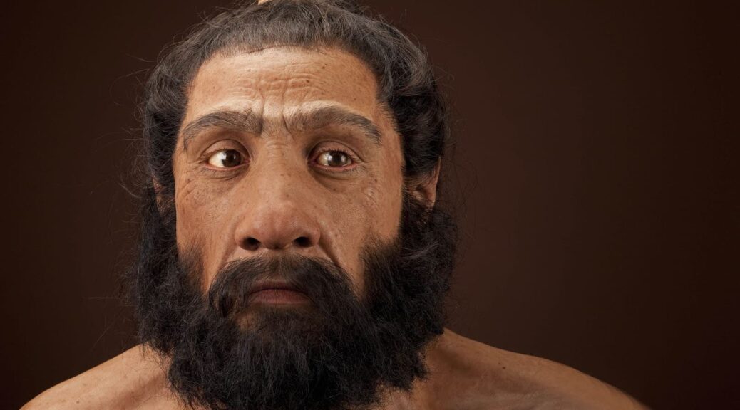
Study of Ancient Skulls Sheds Light on Human Interbreeding With Neandertals
Research has established that there are traces of Neandertal DNA in the genome of modern humans. Now an exploratory study that assessed the facial structure of prehistoric skulls is offering new insights and supports the hypothesis that much of this interbreeding took place in the Near East – the region ranging from North Africa to Iraq.
Homo neanderthalensis adult male. Reconstruction based on Shanidar 1 by John Gurche for the Human Origins Program, NMNH.
“Ancient DNA caused a revolution in how we think about human evolution,” says Steven Churchill, co-author of the study and a professor of evolutionary anthropology at Duke University.
“We often think of evolution as branches on a tree, and researchers have spent a lot of time trying to trace back the path that led to us, Homo sapiens. But we’re now beginning to understand that it isn’t a tree – it’s more like a series of streams that converge and diverge at multiple points.”
“Our work here gives us a deeper understanding of where those streams came together,” says Ann Ross, corresponding author of the study and a professor of biological sciences at North Carolina State University.
“The picture is really complicated,” Churchill says. “We know there was interbreeding. Modern Asian populations seem to have more Neandertal DNA than modern European populations, which is weird – because Neandertals lived in what is now Europe. That has suggested that Neandertals interbred with what are now modern humans as our prehistoric ancestors left Africa, but before spreading to Asia.
Our goal with this study was to see what additional light we could shed on this by assessing the facial structure of prehistoric humans and Neandertals.”
“By evaluating facial morphology, we can trace how populations moved and interacted over time,” Ross explains. “And the evidence shows us that the Near East was an important crossroads, both geographically and in the context of human evolution.”
For this study, the researchers collected data on craniofacial morphology from the published literature. This ultimately resulted in a data set including 13 Neandertals, 233 prehistoric Homo sapiens, and 83 modern humans.
The researchers focused on standard craniofacial measurements, which are reproducible, and used those measurements to assess the size and shape of key facial structures.
This then allowed the researchers to do an in-depth analysis to determine whether a given human population was likely to have interbred with Neandertal populations, as well as the extent of that likely interbreeding.
“Neandertals had big faces,” Churchill says. “But size alone doesn’t establish any genetic link between a human population and Neandertal populations. Our work here involved a more robust analysis of the facial structures.”
The researchers also accounted for environmental variables that are associated with changes in human facial characteristics, to determine the likelihood that connections they established between Neandertal and human populations were the result of interbreeding rather than other factors.
“We found that the facial characteristics we focused on were not strongly influenced by climate, which made it easier to identify likely genetic influences,” Ross says. “We also found that facial shape was a more useful variable for tracking the influence of Neandertal interbreeding in human populations over time.
Neandertals were just bigger than humans. Over time, the size of human faces became smaller, generations after they had bred with Neandertals. But the actual shape of some facial features retained evidence of interbreeding with Neandertals.”
“This was an exploratory study,” Churchill says. “And, honestly, I wasn’t sure this approach would actually work – we have a relatively small sample size, and we didn’t have as much data on facial structures as we would have liked. But, ultimately, the results we got are really compelling.
“To build on this, we’d like to incorporate measurements from more human populations, such as the Natufians, who lived more than 11,000 years ago on the Mediterranean in what is now Israel, Jordan and Syria.”
Earthen Mound in Louisiana Dated to 11,000 Years Ago
New research reveals more information about the Louisiana State University (LSU) Campus Mounds, including the discovery of thousands of years old charred mammal bone fragments and a coordinated alignment of both mounds toward one of the brightest stars in the night sky.
The Louisiana State University (LSU) Campus Mounds pictured here are the oldest known man-made structures in North America.
This new information offers more insight into the oldest known man-made structures in North America.
The two large, grassy mounds that are about 20 feet tall, on LSU’s campus, are among the more than 800 man-made, hill-like mounds in Louisiana, built by ancient indigenous people. While many mounds in the region have been destroyed, the LSU Campus Mounds have been preserved and are listed on the National Register for Historic Places.
“There’s nothing known that is man-made and this old still in existence today in North America, except the mounds,” said LSU Department of Geology & Geophysics Professor Emeritus Brooks Ellwood, who led this study, published in the American Journal of Science by Yale University.
He and colleagues collected sediment cores from the two mounds that are located on LSU’s campus along Dalrymple Drive to learn more about them. The cores revealed layers of ash from burned reed and cane plants, as well as the burned osteons.
Radiocarbon dating of the layers of material indicates the mounds were built over thousands of years. These findings show that people began to build the first mound about 11,000 years ago.
The scientists think that sediment for the southern mound, which they’ve named “Mound B,” was taken from a location immediately behind LSU’s Hill Memorial Library because there is a large depression in the ground there. The mound was built up over a few thousand years, layer by layer, to about half of its current height.
The layers of ash and charred microscopic bone fragments may indicate the mound was used for ceremonial purposes, which included burning reed and cane plants to make large, hot fires that would have been too hot for cooking.
The scientists do not know what type of mammals were cremated or why. However, they found many microscopic, charred bone fragments, known as osteons, the building blocks of large mammal bones, in the ash beds in both LSU Campus Mounds.
Then, around 8,200 years ago, the southern Mound B was abandoned. Tree roots found in the 8,200-year-old sediment layer indicate that the mound was not used for about 1,000 years.
Also around 8,200 years ago, the northern hemisphere experienced a major climate event with temperatures suddenly dropping on average by about 35 degrees Fahrenheit, which lasted about 160 years.
“We don’t know why they abandoned the mounds around 8,200 years ago, but we do know their environment changed suddenly and dramatically, which may have affected many aspects of their daily life,” Ellwood said.
Then, around 7,500 years ago, the indigenous people began to build a new mound just to the north of the first mound. However, this time, they took mud from the floodplain where the entrance to LSU’s Tiger Stadium is currently located, which at that time was an estuary. With this mud, they built the second mound, “Mound A,” layer by layer, to about half of its current height.
Mound A contains mud that is saturated with water, which liquefies when agitated. As a result, Mound A is unstable and degrading, which is why it is critical to stay off the mounds to preserve them.
According to the new analyses of the sediment layers and their ages, it looks like indigenous people cleared the abandoned first-built Mound B and began to build it up to its current height before completing Mound A.
Both mounds were completed around 6,000 years ago and are similar in height.
The crests of both mounds are aligned along an azimuth that is about 8.5 degrees east of true north.
According to LSU astronomer and study coauthor Geoffrey Clayton, about 6,000 years ago, the red giant star Arcturus would rise about 8.5 degrees east of north in the night sky, which means it would have aligned along the crests of both LSU Campus Mounds. Arcturus is one of the brightest stars that can be seen from Earth.
“The people who constructed the mounds, at about 6,000 years ago, coordinated the structures’ orientation to align with Arcturus, seen in the night sky at that time,” Ellwood said.
Still, there is more to learn and discover about these archaeological treasures on LSU’s campus.
Part of a pottery drinking beaker discovered at the High Hunsley site
Archaeologists excavating a site in East Yorkshire say they may have stumbled on a medieval alehouse. Volunteers have spent the past three weeks searching for the remains of a village at High Hunsley, near Beverley.
Assistant site director Emma Samuel said a large number of pottery beakers and jugs had been unearthed, suggesting a pub may once have served the village.
Also found were sheep and cattle bones, giving rise to an alternative theory there was a hostelry, said Ms Samuel.
A knife believed to have been from either the 13th or 14th Century
She said: “From their design, we know the beakers date back to about the 13th Century. The site could well have been a pub or some kind of large house, perhaps even a hostelry.
“The bones, belonging to sheep and cows, were carefully butchered. Perhaps people gathered here to eat? There may well have been a hostelry here.”
Ms Samuel said in medieval times it was dangerous to travel at night, so people on the move would seek out a place to stay.
“People would stop and rest,” he said. “It was a myth that everyone owned horses back then. They didn’t. Horses were expensive. People would often walk. People had to stay overnight somewhere when making long journeys.”
The three-week “community dig” led by Humber Timelines and Ethos Heritage CIC also unearthed a knife, chisels and jewellery from between the 7th and 13th Centuries, including a clasp used to fasten a shirt, a hair pin and a copper brooch, thought to be of Celtic origin.
Geophysical surveys of the site show what appears to be buried houses
Prior to the dig, geophysical surveys of the site revealed more than a dozen stone structures, as well as a larger building, which may have been the pub or hostelry, the team believes.
Ms Samuel, a director at Ethos Heritage CIC, said she suspected the settlement probably had its origins rooted in the 7th Century, or even earlier, although further work was required to confirm this.
Teams plan to return to the site next year to resume excavations.
Burials Discovered in Peru’s Vichama Archaeological Complex
At Vichama Archaeological Complex work has resumed. As a result, funerary complexes and various objects have been found. Similarly, a structure was located that might have served as a home.
Alexander Zuñiga, an archaeologist who works on this project led by Dr. Ruth Shady, explained that some searches were carried out near the monumental area. They were lucky in some of them and discovered funerary contexts.
The specialist indicated that there was no pattern in the position in which the ancient inhabitants of Vichama used to be buried.
Likewise, he noted that some offerings were found with these bundles. The most striking ones were two toads.
Between the valley and the sea
The archaeologist stated that among the rescued pieces there were tools for working cotton and objects made with the remains of molluscs or other marine animals.
This fact is not accidental. Vichama is close to the sea. A considerable percentage of the population of what is now Vegueta lives from fishing activities.
It is also close to the Huaura Valley.
Snakes and toads
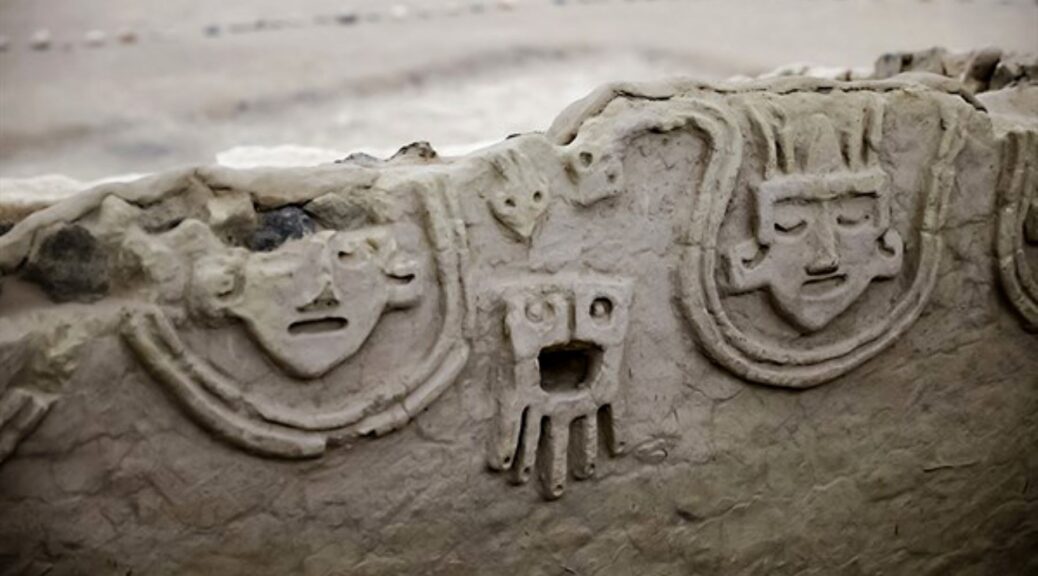
The archaeologist explained that, at the time that Vichama was occupied, some beliefs were changing. For example, in later times the buildings were arranged facing the valley and the walls were decorated with toad figures.
In earlier stages, these buildings faced north and had other types of decoration. In some high reliefs, figures of humans, snakes, and fish are seen.
These will also be seen by the public next weekend on the occasion of the 15th anniversary of this archaeological project.
Archaeologist Zuñiga pointed out that the oldest pieces found and dated in Vichama are 3,800 years old.
Nonetheless, there is evidence that there are older constructions. The constant, so far, are the sunken circular squares of the Caral Culture.
400-year-old Ship Figurehead from 80 Years War Caught By Dutch Shrimpers!
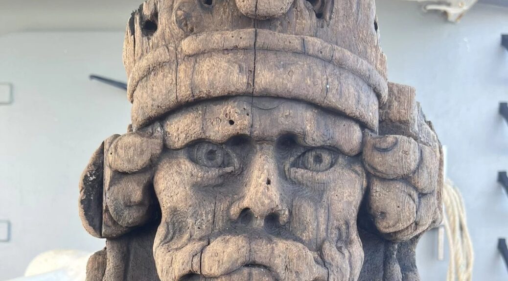
A carved wooden statue in exceptional condition has been attached to fishing nets off the coast of Texel, one of the Dutch Wadden Islands. On Tuesday, August 1, the crew of the shrimp boat Wieringer 22 caught the sculpture.
The rare and exceptionally preserved Dutch wooden ship figurehead was found off the island of Texel in the Wadden Islands in early August 2022.
The crew that named the statue Barry posted it on social media where he garnered an instant following.
Considering that it might have been submerged since the 17th century, their unexpected solid oak haul was astonishingly well preserved.
The head is made of oak, which would normally be vulnerable to shipworm depredations, but the sculpture avoided this fate by embedding itself in the sea floor after the wreck.
The sediment kept marine organisms from eating the figurehead and kept it from rotting. That is the only reason it is in such excellent condition.
Acting on advice from archaeologists, the crew placed the head in an eel tub filled with seawater to keep the wood from drying out and deteriorating while the ship was still out shrimping.
According to Michiel Bartels, a municipal archaeologist for that region of the Netherlands, the “very special discovery” came from a warship, possibly during the Eighty Years’ War, which lasted from the mid-1500s to the mid-1600s.
Archaeologist Michiel Bartels said the man in the carving wore a special headdress called a Phrygian cap.
Bartels added, “This hat symbolizes freedom and independence,” he said. “The Phyrigians were enslaved by the Romans. Slaves were shaved bald. When released from slavery, [Phyrigians] wore a cap to hide their baldness and signify their freedom.”
Bartels, the local archaeologist, thinks that finding Barry could be a sign that someone needs to do a bit more underwater exploration in that area.
Phrygian cap
In European and colonial cultures, the idea of liberty has long been connected with red Phrygian or “liberty” caps. They became symbols of allegiance to the republican cause after being worn and used as icons during the French and American Revolutions in the late 1700s.
Phrygian caps are soft conical hats with the top curled forward. Although these hats, named after Phrygia, a part of modern Turkey, are associated with many ancient nations, the oldest depiction of the Phrygian cap is from Persepolis in Iran.
Prisoner with Phrygian cap (Roman statue from the 2nd century), Louvre
The Phrygian cap was associated in ancient times with various peoples in Eastern Europe and Anatolia, including the Persians, Medes, and Scythians, as well as in the Balkans, Dacia, Thrace, and Anatolia.
In ancient Rome freed slaves wore a similar style of hat, called the pileus, to indicate their liberty. In Europe, it was later assumed that the pileus and the Phrygian caps were one and the same.