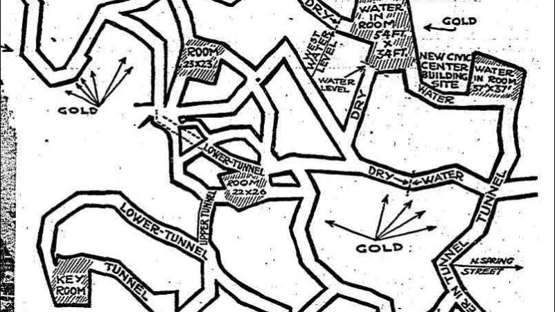
Nabta Playa: The world’s first astronomical site was built in Africa and is older than Stonehenge

Nabta Playa: The world’s first astronomical site was built in Africa and is older than Stonehenge

Ancient societies all around the world erected massive stone circles like celestial clocks, aligning them with the sun and stars to mark solstices. These early calendars foretold the coming of the seasons, helping civilizations track when to plant and harvest crops. They were also connected with religion and served as special ceremonial sites.

Located in Africa, Nabta Playa was once a large internally drained basin in the Nubian Desert, located approximately 800 kilometres south of modern-day Cairo and about 100 kilometres west of Abu Simbel.

Today the region is characterized by numerous archaeological sites. The Nabta Playa archaeological site, one of the earliest of the Egyptian Neolithic Period, dated to circa 7500 BC.

By the 7th millennium BC, exceedingly large and organized settlements were found in the region, relying on deep wells for sources of water. Huts were constructed in straight rows. Sustenance included fruit, legumes, millets, sorghum and tubers. Also in the late 7th millennium BC, but a little later than the time referred to above, goats and sheep, apparently imported from Western Asia, appear. Many large hearths also appear.

In the 1960s, a prominent American archaeologist named Fred Wendorf wanted to search for the ancient origins of Pharaonic Egypt, away from the Nile River. When he was taken out to the site, he first thought they were natural formations. But he soon realized that the site was once a large lakebed that would have destroyed any such rocks. He would return many times over the course of decades. Then, during excavations in the early 1990s, Wendorf and a team of excavators, including Polish archaeologist Romuald Schild, uncovered a circle of stones that seemed to be aligned with the stars in some mysterious way.

Nabta Playa: The world's first astronomical site was built in Africa and is older than Stonehenge

THE FIRST ASTRONOMICAL OBSERVATION

By the 5th millennium BC, these peoples had fashioned what may be among the world’s earliest known archaeoastronomical devices (roughly contemporary to the Goseck circle in Germany and the Mnajdra megalithic temple complex in Malta). These include alignments of stones that may have indicated the rising of certain stars and a “calendar circle” that indicates the approximate direction of summer solstice sunrise. “Calendar circle” may be a misnomer as the spaces between the pairs of stones in the gates are a bit too wide, and the distances between the gates are too short for accurate calendar measurements.” An inventory of Egyptian archaeoastronomical sites for the UNESCO World Heritage Convention evaluated Nabta Playa as having “hypothetical solar and stellar alignments.”

Astrophysicist Thomas G. Brophy suggests the hypothesis that the southerly line of three stones inside the Calendar Circle represented the three stars of Orion’s Belt and the other three stones inside the calendar circle represented the shoulders and head stars of Orion as they appeared in the sky. These correspondences were for two dates – circa 4800 BC and at precessional opposition – representing how the sky “moves” long term. Brophy proposes that the circle was constructed and used circa the later date, and the dual date representation was a conceptual representation of the motion of the sky over a precession cycle.

Near the Calendar Circle, which is made of smaller stones, there are alignments of large megalithic stones. The southerly lines of these megaliths, Brophy shows, aligned to the same stars as represented in the Calendar Circle, all at the same epoch, circa 6270 BC. The Calendar Circle correlation with Orion’s belt occurred between 6400 BCE and 4900 BC, matching the radio-carbon dating of campfires around the circle.

NEW SUGGESTIONS

A 2007 article by a team of University of Colorado archaeoastronomers and archaeologists (three members had been involved in the original discovery of the site and its astronomical alignment) has responded to the work of Brophy and Rosen, in particular their claims for an alignment with Sirius in 6088 and other alignments which they dated to 6270, saying that these dates were about 1,500 years earlier than the estimated dates. The Sirius alignment in question was originally proposed by Wendorf and Malville, for one of the most prominent alignments of megaliths labelled the “C-line”, which they said aligned to the rising of Sirius circa 4820 BCE.

Brophy and Rosen showed in 2005 that megalith orientations and star positions reported by Wendorf and Malville were in error, noting that “Given these corrected data, we see that Sirius actually aligned with the C-line circa 6000 BCE. We estimate that 6088 BCE Sirius had a declination of -36.51 degrees, for a rising azimuth exactly on the C-line average”. Malville acknowledged the corrections made by Brophy and Rosen, but concluded the C-line of megaliths “may not represent an original set of aligned stele; we refrain from interpreting that alignment.”

They also criticised suggestions made by Brophy in his book The Origin Map that there was a representation of the Milky Way as it was in 17,500 BCE and maps of Orion at 16,500 BC, saying “These extremely early dates as well as the proposition that the nomads had contact with extraterrestrial life are inconsistent with the archaeological record. Inference in archaeoastronomy must always be guided and informed by archaeology, especially when substantial fieldwork has been performed in the region.

They propose that the area was first used as what they call a “regional ceremonial centre” around 6100 BC to 5600 BC with people coming from various locations to gather on the dunes surrounding the playa where there is archaeological evidence of gatherings which involved large numbers of cattle bones, as cattle were normally only killed on important occasions.

Around 5500 BCE a new, more organised group began to use the site, burying cattle in clay-lined chambers and building other tumuli. Around 4800 BC a stone circle was constructed, with narrow slabs approximately aligned with the summer solstice, near the beginning of the rainy season.

More complex structures followed during a megalith period the researchers dated to between about 4500 BC to 3600 BC. Using their original measurements and measurements by satellite and GPS measurements by Brophy and Rosen they confirmed possible alignments with Sirius, Arcturus, Alpha Centauri and the Belt of Orion. They suggest that there are three pieces of evidence suggesting astronomical observations by the herdsmen using the site, which may have functioned as a necropolis.

“The repetitive orientation of megaliths, stele, human burials and cattle burials reveals a very early symbolic connection to the north.” Secondly, there is the orientation of the cromlech mentioned above. The third piece of evidence is the fifth-millennium alignments of stele to bright stars.

They conclude their report by writing that “The symbolism embedded in the archaeological record of Nabta Playa in the Fifth Millennium BC is very basic, focussed on issues of major practical importance to the nomads: cattle, water, death, earth, sun and stars.”

Man Finds Secret Window Hidden Behind Wallpaper in 19th-Century Home

Man Finds Secret Window Hidden Behind Wallpaper in 19th-Century Home

A man discovered a secret window hidden behind wallpaper in his house, thought to date back to the 19th century, as he lovingly renovated the property. Alex Howard is restoring the antique grandeur to his home, in Edinburgh, Scotland, and has been sharing progress to his TikTok page, @housedoctoralex.

Howard, an author, has been painstakingly removing all the woodchip wallpaper throughout the house—similar to popcorn style—when he found something unusual lurking behind the hardboard. He shared a clip of himself up a ladder armed with a wallpaper scraper, as he pokes a hole through the covering, and realizes there’s something on the other side. Howard immediately rips off the wallpaper, shouting “window” as he uncovered the black-rimmed frame. He captioned the video, which can be seen here: “Wtf I found a hidden window in my flat,” adding: “Well that was unexpected.”

In the comments, he revealed the woodchip was “getting steamed off and re-lined next month,” explaining the window was covered by flimsy sheets of hardboard. Speaking to Newsweek, Howard explained the two-bedroom apartment was built around 1890, and he and his wife are slowly returning it to its former glory after it’s “no doubt been home to countless students and tyrannical landlords over the years.”

He said: “There’s nearly always a window connecting the kitchen alcove and a box room (which has often been converted into a kitchen bathroom). Presumably, it was the Victorian idea of giving that little interior space some natural light. In fact, I learnt only yesterday they are called ‘borrow windows,’ presumably because you’re borrowing light from another room.

“When we arrived, I did that classic ‘dad’ thing of tapping up the wall to hear if the tone changed. Sure enough, I discovered that the window had just been dry-walled over. The fact that there was then a layer of woodchip on top of that, suggests that it was done at least as far back as the 70s.”

He added the glass was single-glazed, saying: “They’re that old pre-war ripply glass like all the windows in this flat. All our windows make things look a bit wibbly, and distorted when you look through them because of the more unrefined, pre-war glazing techniques. You can see the oddly replaced pane because it doesn’t distort.”

Photo of the hidden windows. Alex Howard discovered secret windows lurking underneath wallpaper in his 19h-century house.

The clip, shared in June, amassed more than 400,000 views, and people were so intrigued that Howard shared a follow-up clip. It shows he found a pair of windows, with two panes each, covered up between two rooms.

“So some of you have been asking about the backstory to these here windows that I discovered yesterday,” he said.

Howard, who moved in two months ago, gave viewers a mini-tour, saying: “I’ve worked it out, follow me down the hall, and into the box room. But why you might say might one block windows to a box room.

“It was once a bedroom. The reason I know is that up here there’s a light switch which controls the lights in the room. This means at some point there was a mezzanine level up here with a bed installed when this was rented out as its own separate bedroom.

“Some of you may have heard of HMO, or houses in multiple occupancies, before this was introduced any room could be rented out to someone regardless of whether or not it had a window in it. Thankfully we live in more enlightened times now and you can only let out a room if it’s got a window.”

It’s thought that as the window connects two rooms, rather than leading to the outside, they were covered to give each tenant privacy.

Howard explained: “This is what we’re putting the blocked-up window down to—the room on the other side is a box room with its plug sockets/switches mounted high up the wall. We reckon it was rented out as a room with a mezzanine bed, pre-HMO regulations when landlords crammed these flats full of students to cash in.

“But what is clear is that the blocked-up window is an attempt to make that postage stamp of a box room ‘private.’ Pretty sad to think that tiny, windowless space was some poor student/servant’s room at one point!”

He added that the smaller room was what the U.K. refers to as a “box room,” which is essentially a glorified cupboard, which is why the bed was on a mezzanine.

READ ALSO: UNDERGROUND LABYRINTH WITH SECRET PASSAGES, AND TUNNELS IN DOBROGEA PLATEAU, ROMANIA

Howard clarified they’re “just a bit bigger than a walk-in cupboard,” adding: “They’re small rooms, bigger than a cupboard but smaller than a conventional room, that was traditionally used for lodgers. This one’s about 6×5.'”

Numerous people commented on the original clip, with Liam Burgeson asking: “Who does these things.”

Mecha_genki said: “We had this too! Didn’t notice it because it was on the side we never went down”

While MissMisty wrote: “Why was the window covered in craft paper? Lean against it too hard and your arm would go through.”

Marvin Harold joked: “Previous owner must have worked nights.”

Burial Mounds in Serbia reveal skeletons of 5,000-year-old painted men

Burial Mounds in Serbia reveal skeletons of 5,000-year-old painted men

Archaeologists have discovered dye-coloured bones dating back around 5,000 years at a burial site in southeastern Europe where unusually tall men were laid to rest.

Burial Mounds in Serbia reveal skeletons of 5,000-year-old painted men
A reconstruction of the tomb and one of the immigrants from the northeast steppes was found in the sacred burial mounds on the plains of Serbia.

The burial site, located in Vojvodina in northern Serbia, was excavated by researchers between 2016 and 2018. However, only recently was expert analysis carried out.

The burial site consisted of two large mounds 131 feet across and between 10 and 13 feet tall.

Inside, the researchers found that some bones were marked with red colouring, thought to be due to “the use of ochre on the bodies of the dead,” according to Piotr Włodarczak from the Institute of Archaeology and Ethnology of the Polish Academy of Sciences, one of the excavation supervisors, in a statement to the government-affiliated Science in Poland public information service.

Ochre is a type of earth that has been coloured by iron oxide. This can give it a red hue and it has been used as a colouring pigment. Red in particular was considered sacred by some, Włodarczak said.

Another thing the researchers noticed about the remains is that the deceased men were over 1.8 meters tall, or around 5 ft. 11 in. This would have been an above-average height for the time—it’s thought that the men were buried around 3,000 BCE, and men living in this part of Europe then would usually have been about 1.6 meters or 5 ft. 3 in. tall, according to Science in Poland.

The height of the men, as well as the use of ochre, led the researchers to believe that they were newcomers to the region and had probably come there from the steppes of what would be south Russia or Ukraine today.

Genetic analysis of the remains suggested the men had themselves come from this region or were immediate descendants of people who did.

The influx of nomads from eastern to more western parts of Europe in this period would have had a significant impact on the culture of Europe, Włodarczak said.

READ ALSO: THREE WELL-PRESERVED ANCIENT BOATS UNEARTHED IN SERBIA

It’s not the only significant archaeological finding to be reported recently. In the United Kingdom last week, a Roman mosaic hidden beneath the streets of London for more than 1,500 years was discovered.

The 26-foot-long mosaic was found at a construction site near the capital’s largest building, The Shard. It’s set to be transported for preservation later this year and there are hopes it will be publicly displayed in future. It’s thought that the mosaic may have been part of a large dining room called a triclinium.

Archaeologists also recently unearthed a 4,000-year-old board game from the Bronze Age in Oman.

A stock photo shows an archaeologist using a brush to carefully examine something in the ground. Archaeologists in Serbia have found burial sites of people who are thought to have travelled there thousands of years BCE.

Pottery Analysis Offers Clues to Caribbean Island Trade Routes

Pottery Analysis Offers Clues to Caribbean Island Trade Routes

With some 7,000 islands and cays and 7,000-year history of human habitation, the Caribbean Sea is practically synonymous with maritime travel. The very word “canoe” is derived from the term “kana:wa,” used by the Indigenous Arawakans of the Caribbean to describe their dugout vessels.

Without clear road signs to indicate where native islanders were travelling, however, the task of reconstructing ancient trade routes relies on subtle clues locked away in the archaeological record. Researchers at the Florida Museum of Natural History recently turned to pottery to tease apart the navigational history of the Caribbean, analyzing the composition of 96 fired clay fragments across 11 islands.

The study, published in the Journal of Archaeological Science: Reports, is the broadest of its kind yet conducted in the Greater Antilles and marks the first time that pottery artefacts from the Lucayan Islands — The Bahamas plus the Turks and Caicos Islands — have been analyzed to determine their elemental composition and origin.

Pottery Analysis Offers Clues to Caribbean Island Trade Routes
Pottery from the Caribbean are relatively durable and are often the most common artifacts unearthed from archaeological sites.

“Our methods mark a big improvement over other studies that mostly look at a single site or single island, where you might see differences but not know what it means because you’re looking at the results in isolation,” said co-author Lindsay Bloch, a courtesy faculty member with the Florida Museum’s Ceramic Technology Lab.

People have lived on the Caribbean islands on and off for more than 7,000 years, migrating in waves from Central and South America. As early as 800 B.C., new groups arrived from Venezuela and established a trading network among islands, which they used to exchange food, tools and jewellery. But the most common artefacts that survived to the present are the pottery vessels these objects were carried in.

“Most materials don’t preserve well in the Caribbean because of the warm, humid environment, but pottery is durable, so it ends up being one of the most common things we find,” said lead author Emily Kracht, a collections assistant in the Ceramic Technology Lab.

Over the ensuing millennia, different Caribbean cultures developed unique styles and techniques for constructing their pottery. Some artefacts are simple and unadorned, while others are highly decorated, with a lattice of incised lines, punctuations, raised ridges and flared rims.

Indigenous Caribbean islanders developed elaborate and ornate pottery styles that varied across time and between cultures.

Many studies have relied almost entirely on similarities in style to distinguish between different cultures and infer their movements. But, as Bloch explains, this method has often left more questions than answers and excludes material with potentially valuable information.

“The vast majority of pottery that we find anywhere in the world is going to be undecorated. It’s going to be things used for cooking or storage, which are typically plain and often get ignored because they’re seen as generic,” she said.

Rather than studying the minutiae of varying styles, the researchers focused instead on what the pottery was made of. Using a laser to etch microscopic lines into their samples, the researchers determined the exact amounts and identities of each element in the clay used to make the pottery. Their final analysis included more than seven decades’ worth of archaeological collections that span over 1,000 years of Indigenous Caribbean history.

“One of the advantages of elemental analysis is that we’re explicitly looking for differences, which allows us to see where a pot was made and compare that to where it ended up,” Bloch said.

The researchers removed small fragments from pottery vessels and embedded them in resin before analyzing their elemental composition.
Lead author Emily Kracht prepares the resin blocks and embeds pottery fragments for elemental analysis.

Such detailed comparisons are possible due to the complexity of the Caribbean’s underlying geology. The largest islands in the archipelago likely got their start as an ancient underwater plateau in the Pacific Ocean. After the breakup of the supercontinent Pangaea, the Caribbean plate drifted east in a flurry of volcanic eruptions that elevated the plateau above sea level before ultimately reaching its current position in the Atlantic.

Millions of years of weathering reduced these volcanic outcrops into fine-grained clays with differing concentrations of elements like copper, nickel, chromium and antimony. These differences mean that even the smallest Caribbean pottery sherd bears the elemental signature of the region it was made in.

The results of researchers’ comparative analysis aren’t what might be expected by simply looking at a map. The Lucayan Islands were initially used only temporarily for harvesting resources, and the people who travelled to them would have set sail from the larger islands to the south that supported permanent population centres.

Cuba might initially seem like it’s the perfect staging ground for these operations, being by far the largest Caribbean island and the closest to The Bahamas. While people did make the trek across open water from Cuba, the results of the study indicate the Caribbean’s cultural hub was instead centred on the northwest coast of Hispaniola, from which people imported and exported goods for hundreds of years.

“At least some of the pottery would have been used to ferry goods out to these islands, and people would potentially carry back a variety of marine resources,” Bloch said.

People eventually struck up permanent settlements in The Bahamas and Turks and Caicos, becoming collectively known as the Lucayans, or the People of the Islands. They began making their own pottery from claylike soils deposited by African dust plumes blown in from the Saharan Desert, but the results didn’t quite hold up to the pottery from Hispaniola — literally. Lucayan pottery, called Palmetto Ware, is most often thick and soft and crumbles over time due to the poor quality of the grainy Saharan soil.

Thus, up until the arrival of the Spanish, Hispaniola remained the main trading partner and exporter of pottery to the Lucayan Islands.

“We knew that the Lucayans were related to people in Hispaniola, and this study shows their enduring relationship over hundreds of years through pottery,” Kracht said.

Australia’s first marine Aboriginal archaeological site questioned

Australia’s first marine Aboriginal archaeological site questioned

A new study from The University of Western Australia has challenged earlier claims that Aboriginal stone artefacts discovered off the Pilbara coast in Western Australia represent Australia’s first undisturbed underwater archaeological site.

Map of the Dampier Archipelago (Murujuga) showing locations of areas mentioned in the text. (Contains modified Copernicus Sentinel data [2020] processed by Sentinel Hub).

The original findings were made in a study published in 2020 in PLOS ONE, by a team of archaeologists and scientists from Flinders University, UWA, James Cook University, ARA (Airborne Research Australia) and the University of York.

The team partnered with the Murujuga Aboriginal Corporation to locate and investigate stone scatters at two sites in the Dampier Archipelago.

The “underwater” sites at Cape Bruguieres included hundreds of stone tools found in an area that was dry land many thousands of years ago.

Co-author of the new paper, published in Geoarchaeology, geoarchaeologist Dr. Ingrid Ward from UWA’s School of Social Sciences, said it questioned two key claims made in the original paper—that the artefacts were “permanently submerged” and that they were “in situ” and had not been moved since their original deposition.

“In fact, the artefacts occur in a channel ponded well above the lowest tide, so are not permanently submerged,” Dr. Ward said.

“Further, past and present oceanographic and sediment transport processes indicate that the lithic artefact scatters have almost certainly been moved by waves and currents away from where they were first discarded.”

The new study was carried out in collaboration with UWA’s Dr. Piers Larcombe, Dr. Peter Ross of Flinders University and Dr. Chris Fandry of RPS Energy.

The multidisciplinary team examined the assumptions and claims made in the original paper, concluding that the analysis had been insufficient to justify its findings.

“It remains untested how old the artefacts are—they could be 200 years old, 2,000 years old or 20,000 years old—it is completely unknown at this stage,” Dr. Ward said.

Despite this, she said we could still learn a lot from reworked sites.

“For all archaeological sites, the scientific narrative depends on defensible interpretation, which means understanding the processes that have formed the sites we find today,” she said.

“Science progresses through repeated cycles of research, publication, challenge and correction, and papers that challenge ideas are a normal part of healthy science. Archaeological research of indigenous coastal and marine sites in Australia is still at an early stage.”

Enduring Mystery Surrounds the Ancient Site of Puma Punku

Enduring Mystery Surrounds the Ancient Site of Puma Punku

High up the Bolivian altiplano,’ south of Lake Titicaca and the ancient complex of Tiahuanaco, we find the ancient ruins of Puma Punku.

Believed to have been erected by the ancient Tiwanaku culture in the bronze age, between 1,000 and 2,000 years ago, the ancient site is home to some of the most fascinating ancient stone structures on the surface of the planet.

Shrouded in mystery, the archaeological site of Puma Punku is one of the biggest headaches for mainstream archaeologists who are unable to explain how ancient cultures cut and shaped granite stone to incredible precision, transported blocks of stones that weigh more than 50 tons, and placed them in a position like a puzzle so that not a single sheet of paper can fit between them.

But if that wasn’t enough of a mystery, there’s that LITTLE magnetic anomaly present at Puma Punku.

The question that arises here is… how on Earth did the ancients transport these massive blocks of stone, tens of tons in weight across 70 kilometres from their quarry to Puma Punku?

Puma Punku: reconstruction

The Magnetic Anomaly

This mysterious feature which makes Puma Punku even stranger was spotted by researcher and author Brien Foerster.

In a video uploaded onto his YouTube account, Brien Foerster takes us on a trip to the Bolivian Altiplano where he tours through Puma Punku and shows us how certain rocks at the site – Puma Punku’s Grey Stones – display magnetic anomalies.

These curious features have been completely ignored and left unattended by scholars who have studied Puma Punku in the past.

Here is another video where we can see the curious magnetic anomaly present on the grey stones of Puma Punku.

Still, think Puma Punku is just another ordinary ancient site? Think again.

Possible Medieval Children’s Cemetery Found in Southern Turkey

Possible Medieval Children’s Cemetery Found in Southern Turkey

Possible Medieval Children’s Cemetery Found in Southern Turkey

A furnace for commercial production and a child’s grave with glass bracelets and gifts inside has been found for the first time during this year’s excavations in the ancient city of Kelenderis, established on the Mediterranean coast in the southern province of Mersin 2,800 years ago.

Located next to a fisherman’s shelter in the Aydıncık district on the Mersin-Antalya highway, the excavation and restoration/conservation works started in 1987 in the ancient city of Kelenderis and have been ongoing for 35 years uninterruptedly.

For the first time, the skeleton of a child, who was buried with four solid glass bracelets on his arm, gifts, clothes and a wooden coffin, has been unearthed in the ancient city, where nearly 150 tombs have also been found around the Odeon over the last 35 years.

In addition, during the excavations conducted in the region, a furnace, which is thought to be used for tile production, was unearthed for the first time, documenting commercial production.

Speaking about the exciting discovery, the head of the excavations Mahmut Aydın said, “Excavations continue for 12 months of the year in the ancient city of Kelenderis. This year, we have completed the excavation and consolidation of the caves, the sitting area, and the supporting walls behind the Odeon structure.

Now we found a furnace that excites us. We knew for years that there was production here, but we couldn’t find the oven.

The oven is 1,300 years old. We think that roof tiles were produced inside the furnace. Because during the excavations we carried out last year and this year, a large number of roof tiles, dated to the seventh century, were found around the furnace.

Since the roof tiles were faulty, we found them scattered around it. When we completely empty the inside of the furnace, we might find even more faulty roof tiles.”

Speaking about the child’s grave, Aydın said, “We have previously uncovered nearly 150 tombs here, but none of them had burial gifts. In this one, we uncovered four glass bracelets, an inscription on a ceramic piece and a cup. This was a first.

At the same time, there were several baby graves around this child’s grave. We understand from here that a part of the Odeon was used as a children’s burial area.

When the carbon 14 analysis results come, we will be able to identify them more clearly. But we believe that this area was used as a burial area in the Middle Ages. As it is different from other burials, we will only be able to determine exactly when the child died with carbon 14 analysis.”

Indian Farmer Discovers 4,000-year-old Copper Weapons Buried Under a Field

Indian Farmer Discovers 4,000-year-old Copper Weapons Buried Under a Field

We know India is a rich country when it comes to its heritage and culture. Although a lot of evidence has been lost, through destruction, loot or other reasons, findings from time to time prove that indeed India is a heritage-rich country.

We know India is a rich country when it comes to its heritage and culture. Although a lot of evidence has been lost, through destruction, loot or other reasons, findings from time to time prove that indeed India is a heritage-rich country.

It has given the world the teachings of Buddha to learn from, the richness of the Himalayas that make India the hub of a spiritual journey, and more. 

In a recent finding, archaeologists in Agra have found nearly 4000-year-old weapons from beneath the ground in Mainpuri.

The weapons extracted include large swords, some close to 4 feet, and arms having sharp sophisticated shapes. The archaeologists have termed the finding ‘exciting’.

About the finding

According to reports, in the village of Ganeshpur in Mainpuri, a farmer was levelling his field when he found a large number of copper swords and harpoons beneath the soil.

The Archaeological Survey of India (ASI) found a variety of swords, some that archaeologists are calling “antenna swords and harpoons”, with a hook at the bottom.

Some of these weapons had a starfish-like shape. These copper hoards, 77 in number, possibly date back to 1600-2000 BC – the later stages of the Chalcolithic Age (the transition period between the Neolithic and Bronze Ages).  

The findings according to Vasant Swarnkar, D.

In recent Excavations at Sanauli, Baghpat, UP under Dr SK Manjul,
@ASIGoI finds Coffin Burials, furnaces & fascinating artefacts’. The present excavation is carried out to understand the extension of the burial site and also the habitation area in relation to earlier findings in 2018.

The Director of Conservation and spokesperson, suggest that the inhabitants of the area were engaged in fighting, much like the 2018 findings in Sanauli in Baghpat, although that was a burial site.

Earlier in 2018, the ASI in an excavation at Sanauli, Baghpat, Uttar Pradesh found coffin burials, furnaces, and fascinating artefacts.

In 2019, it carried out an excavation to understand the extension of the burial site and also the habitation area in relation to earlier findings. 

The find will undergo Thermoluminescence dating, a technique usually used on pottery and other ceramic material. According to Director Swarnkar, similar discoveries have been made in the past in Sakatpur in Saharanpur, Madarpur in Moradabad, and Saifai district.

All In One Magazine