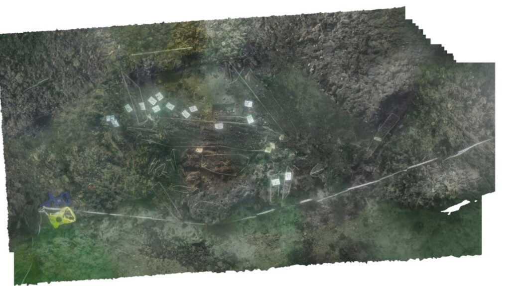
Munigua, a hidden Roman city in the Sevilla sierra, spain
There is no shortage of Roman ruins in Spain. Some are in the middle of modern city centres, such as Mérida’s theatre and amphitheatre, in Extremadura. Or Itálica, which is reachable by bus from Seville. Others are out in the middle of nowhere, at the end of a track, in a random field. This was the case with Munigua, making it a reasonable option to explore in the middle of a pandemic.
Western Wall of the Sanctuary
The story of Munigua
For centuries it was taken for granted that the temple must have been an ancient castle, abandoned after some old war. Only recently, when the Roman inscriptions appeared, the scholars realized that they were dealing with a Roman temple.
But this temple is way too big for the size of the city. We do not know to which deity it was dedicated. Given its enormous size, it must have been a significant Iberian god or goddess.
Munigua was founded in the III century BCE before Romans came. But let’s not lose hope: excavations have been going on for over 60 years, so sooner or later we will know!
The Romans took over the Iberian city because it was located close to very rich mines. But alas, an earthquake destroyed the town in the III century ADE, and it was never rebuilt.
Eastern slope of the site with private and public buildings
The mines had been worn out already, and the city was far away from everything. Some people stayed there to live, especially the Moorish. In Munigua, you can actually see the oldest Moorish tombs in Spain. But it was not an important city anymore. In the XII century, it was definitely abandoned.
Since then, people simply have forgotten that once upon a time, there had been a whole city right in this spot. This is how you find Munigua today: in the middle of the same landscape that the Romans knew -wild, unique, still full of mysteries.
The visit to Munigua
If you plan to go to Munigua, make sure that the weather conditions are right. If it is raining, it will not be opened. On the bright side, the entrance is free.
Bring your drinks and food -there are no shops there. Think of this visit as if you went for a hike to the mountains! Do not forget solar protection -it is Sevilla, so it will be most likely sunny – and comfortable shoes -after all, you are going to walk at least 6 km!
Temple of the Podium
There are few cities in Spain like Munigua. You get to walk around its ancient streets and get inside the very well preserved buildings. The shovels of the archaeologists have dug out thermae, big houses, a forum, temples, some parts of the ancient city wall.
The funny thing about this one… it was never ended. Also, it went through the two necropoleis of the town, which was very strange for a Roman city: the dead people were always left outside. Same thing with the main temple, at the top of the hill: its architecture in terraces is very atypical in the Roman world.
The whole city is built indeed on terraces, with stairs going in all directions, like big chaos, very unlike the civilized Roman order. We can only assume that the previous Iberian inhabitants never entirely left!
The Arctic Could Turn Green and Free of Ice Like it was 125,000 Years Ago
Researchers analyzed plant DNA more than 100,000 years old retrieved from lake sediment in the Arctic (the oldest DNA in lake sediment analyzed in a publication to date) and found evidence of a shrub native to northern Canadian ecosystems 250 miles (400 km) farther north than its current range.
As the Arctic warms much faster than everywhere else on the planet in response to climate change, the findings, published this week in the Proceedings of the National Academy of Sciences, may not only be a glimpse of the past but a snapshot of our potential future.
“We have this really rare view into a particularly warm period in the past that was arguably the most recent time that it was warmer than present in the Arctic. That makes it a really useful analogue for what we might expect in the future,” said Sarah Crump, who conducted the work as a Ph.D. student in geological sciences and then a postdoctoral researcher with the Institute of Arctic and Alpine Research (INSTAAR).
To gain this glimpse back in time, the researchers not only analyzed DNA samples, they first had to journey to a remote region of the Arctic by ATV and snowmobile to gather them and bring them back.
Dwarf birch is a key species of the low Arctic tundra, where slightly taller shrubs (reaching a person’s knees) can grow in an otherwise cold and inhospitable environment. But dwarf birch doesn’t currently survive past the southern part of Baffin Island in the Canadian Arctic. Yet researchers found DNA of this plant in the ancient lake sediment showing it used to grow much farther north.
“It’s a pretty significant difference from the distribution of tundra plants today,” said Crump, currently a postdoctoral fellow in the Paleogenomics Lab at the University of California Santa Cruz.
Tundra Plants
While there are many potential ecological effects of the dwarf birch creeping farther north, Crump and her colleagues examined the climate feedbacks related to these shrubs covering more of the Arctic. Many climate models don’t include these kinds of changes in vegetation, yet these taller shrubs can stick out above snow in the spring and fall, making the Earth’s surface dark green instead of white — causing it to absorb more heat from the sun.
“It’s a temperature feedback similar to sea ice loss,” said Crump. During the last interglacial period, between 116,000 and 125,000 years ago, these plants had thousands of years to adjust and move in response to warmer temperatures. With today’s rapid rate of warming, the vegetation is likely not keeping pace, but that doesn’t mean it won’t play an important role in impacting everything from thawing permafrost to melting glaciers and sea-level rise.
“As we think about how landscapes will equilibrate to current warming, it’s really important that we account for how these plant ranges are going to change,” said Crump.
As the Arctic could easily see an increase of 9 degrees Fahrenheit (5 degrees Celsius) above pre-industrial levels by 2100, the same temperature it was in the last interglacial period, these findings can help us better understand how our landscapes might change as the Arctic is on track to again reach these ancient temperatures by the end of the century.
Mud as a microscope
To get the ancient DNA they wanted, the researchers couldn’t look to the ocean or to the land — they had to look in a lake. Baffin Island is located on the northeastern side of Arctic Canada, kitty-corner to Greenland, in the territory of Nunavut and the lands of the Qikiqtaani Inuit. It’s the largest island in Canada and the fifth-largest island in the world, with a mountain range that runs along its northeastern edge. But these scientists were interested in a small lake, past the mountains and near the coast.
Above the Arctic Circle, the area around this lake is typical of a high Arctic tundra, with average annual temperatures below 15 °F (?9.5 °C). In this inhospitable climate, the soil is thin and not much of anything grows.
But DNA stored in the lake beds below tells a much different story. To reach this valuable resource, Crump and her fellow researchers carefully balanced on cheap inflatable boats in the summer — the only vessels light enough to carry with them — and watched out for polar bears from the lake ice in winter. They pierced the thick mud up to 30 feet (10 meters) below its surface with long, cylindrical pipes, hammering them deep into the sediment.
The goal of this precarious feat? To carefully withdraw a vertical history of ancient plant material to then travel back out with and take back to the lab. While some of the mud was analyzed at a state-of-the-art organic geochemistry lab in the Sustainability, Energy and Environment Community (SEEC) at CU Boulder, it also needed to reach a special lab dedicated to decoding ancient DNA, at Curtin University in Perth.
To share their secrets, these mud cores had to travel halfway across the world from the Arctic to Australia.
A local snapshot
Once in the lab, the scientists had to suit up like astronauts and examine the mud in an ultra-clean space to ensure that their own DNA didn’t contaminate that any of their hard-earned samples.
It was a race against the clock.
“Your best shot is getting fresh mud,” said Crump. “Once it’s out of the lake, the DNA is going to start to degrade.”
This is why older lake bed samples in cold storage don’t quite do the trick. While other researchers have also collected and analyzed much older DNA samples from permafrost in the Arctic (which acts as a natural freezer underground), lake sediments are kept cool, but not frozen. With fresher mud and more intact DNA, scientists can get a clearer and more detailed picture of the vegetation which once grew in that immediate area.
Reconstructing historic vegetation has most commonly been done using fossil pollen records, which preserve well in sediment. But pollen is prone to only showing the big picture, as it is easily blown about by the wind and doesn’t stay in one place. The new technique used by Crump and her colleagues allowed them to extract plant DNA directly from the sediment, sequence the DNA, and infer what plant species were living there at the time. Instead of a regional picture, sedimentary DNA analysis gives researchers a local snapshot of the plant species living there at the time. Now that they have shown it’s possible to extract DNA that’s over 100,000 years old, future possibilities abound.
“This tool is going to be really useful on these longer timescales,” said Crump. This research has also planted the seed to study more than just plants. In the DNA samples from their lake sediment, there are signals from a whole range of organisms that lived in and around the lake.
“We’re just starting to scratch the surface of what we’re able to see in these past ecosystems,” said Crump. “We can see the past presence of everything from microbes to mammals, and we can start to get much broader pictures of how past ecosystems looked and how they functioned.”
Researchers Map World War II Bomb Craters in Poland
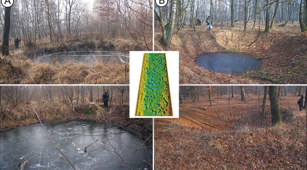
According to a Live Science report, Maria Fajer of the University of Silesia and her colleagues employed lidar technology to record some 6,000 bomb craters in the Koźle Basin, an area of forests and wetlands in southern Poland that was part of Germany during World War II.
Lidar scans revealed thousands of craters in Poland’s Koźle Basin, remnants of intense Allied bombings during 1943 and 1944.
Researchers recently mapped and analyzed the deeply scarred landscape for the first time, counting around 6,000 bomb craters ranging from 16 to 49 feet (5 to 15 meters) in diameter. Some areas held as many as 30 craters in a single hectare (10,000 square meters).
Their investigation presents a grim picture of the damage sustained by the battle-torn terrain, known as the Koźle Basin. But it also offers a glimpse of how the craters have since become an important part of the basin’s natural landscape and ecosystems, the scientists reported in a new study.
The Koźle Basin covers an area of approximately 180 square miles (470 square kilometers). Within the basin, extending for about 60 square miles (150 square km), “there are clusters of remnants of the Allied air campaign conducted there in the second half of 1944,” said study author Maria Fajer, a geomorphology researcher with the Faculty of Earth Sciences at the University of Silesia in Katowice, Poland.
“These are variously preserved bomb craters, ranging from those that are very well visible in the field to traces of backfilled and reclaimed craters,” Fajer told Live Science in an email.
Nazi Germany controlled the Koźle Basin during WWII and used the region for industrial fuel production. It was the biggest such site in the entire Third Reich, the scientists reported. Coal and water were easily accessible there, while dense forests and sheltering hills provided natural cover from air and ground attacks.
Because the basin’s topography trapped air masses, the Germans could add another layer of protection to their operation by producing thick anti-aircraft smoke screens.
Great Britain’s Royal Air Force began targeting the region for the bombing in February 1943, and in June 1944 Americans and British pilots prioritized the destruction of Nazi oil refineries, as well as fuel and chemical factories.
Wartime records describe Allied planes dropping a total of 39,137 bombs in the Koźle Basin. Most of these were delayed-action bombs that were “intended for the destruction of buildings, reinforced concrete, and metal structures, as well as land-cratering,” the scientists reported March 16 in the journal Antiquity.
Uncounted numbers of craters were scoured away during postwar construction and agriculture, and researchers decided to map the region before more evidence of this noteworthy wartime bombardment was lost forever, according to the study.
Allied planes targeted Nazi industrial factories in the Koźle Basin with tens of thousands of bombs.
Scanning with lasers
The researchers deployed a remote sensing method called light detection and ranging, or lidar, which uses laser pulses to peer through vegetation and reveal features in the ground.
By examining the sizes, shapes, and distribution of thousands of craters, the researchers were able to piece together a picture of the types of bombs that were used; how many were dropped at the same time; and ground conditions at the time of impact.
Today, these craters “are relics that document important historical events, and that constitutes a link between the area and the battlefields of Europe and beyond,” the study authors wrote. In the 75 years that have passed since the war, these remnants of violent explosions have gradually become part of the forest habitat.
“They now represent places where many amphibian, reptile, insect, bird, and ungulate species reside, seek shelter, or breed. The craters also provide habitats for numerous plant species,” the study authors wrote.
“The many water bodies and marshes that formed in the bomb craters contribute to the diversification and enrichment of local ecosystems, where sandy soils dominate.”
Many species of animals and plants now make their homes in and around the Koźle Basin craters.
Follow-up studies by the scientists will further explore the ecological role of craters in forest ecosystems and the threats posed by unexploded bombs, Fajer said.
In the decades since WWII, natural processes such as erosion have erased many of the craters, while industry, farming, and other human activities could wipe away still more. Mapping the bomb fields will therefore help to preserve a record of WWII devastation before it vanishes.
The researchers also argue that locations marred by WWII devastation, such as the still-scarred Koźle Basin, should be conserved for future generations. These areas “should be covered by special heritage protection measures to help us remember the consequences of the bad decisions that led to the war,” Fajer said.
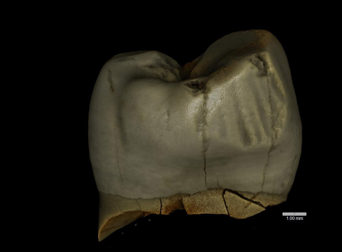
Toothpick Use Identified on Neanderthal Tooth from Poland
Additional evidence of Neanderthal hygiene practices has been unearthed at Stajnia Cave, which is located in south-central Poland, according to a Science in Poland report.
Analyzing two teeth excavated from the Pleistocene layers of the Stajnia Cave (Kraków-Częstochowa Upland), the team led by Dr. Wioletta Nowaczewska from the Department of Human Biology, University of Wrocław, found traces left by a toothpick.
She said: “It appears that the owner of the tooth used oral hygiene. Probably between the last two teeth, there were food residues that had to be removed. We don’t know what he made a toothpick from – a piece of a twig, a piece of bone, or fishbone. It had to be a fairly stiff, cylindrical object, which the individual used often enough to leave a clear trace.”
This is the second known example of such hygienic procedures being practiced by Neanderthals from Stajnia Cave. Similar traces have been preserved on another tooth found earlier in the cave.
Scientists also believe that the teeth, a wisdom tooth (third lower molar) and an upper premolar, belonged to an individual over 30 years old, and the other to a slightly younger male in his twenties.
However, they found no pathological changes indicative of enamel growth disorders, hypoplasia, or caries. They note that the wisdom tooth shows signs of severe wear, which may be related to eating hard food.
To determine whether the tooth belonged to our immediate ancestor (Homo sapiens) or a fossil relative (Homo neanderthalensis), scientists assessed the structure of the tooth’s crown, enamel thickness, dentine surface contour, and crown surface microtrauma.
They compared the data with other data on the teeth of Neanderthals, as well as fossil and contemporary representatives of our species.
Dr. Nowaczewska said: “A set of features, i.e. the presence of a specific combination of features characteristic of Neanderthals indicates that further teeth from Stajnia Cave belonged to them. In the case of the lower molar, one can see a complicated structure: a large number of tubercles. In the front part of the crown, there was also a characteristic depression and enamel formation.
“The good condition of the premolar allowed us to carry out 2D and 3D analysis of enamel thickness, digital reconstruction, virtual ‘pulling’ of the enamel cap and assessment of enamel thickness, which in Neanderthals is thinner than in H. sapiens. All these features taken together point to Neanderthals.”
The teeth were initially discovered in 2010 along with numerous remains of the fauna during excavation works conducted under the supervision of Dr. Mikołaj Urbanowski.
But it is only recently that they have been analyzed using mitochondrial DNA. Dr. Mateja Hajdinjak from the Max Planck Institute for Evolutionary Anthropology the tests along with additional analyses to confirm that the teeth belonged to Neanderthals.
Neanderthal bone remains are rare finds in Central and Eastern Europe (there are slightly more sites related to Neanderthal tools). In today’s Poland, such finds accumulate in the south; northern Poland remained within the reach of the glacier for a long time and the conditions for survival were difficult.
Officially confirmed discoveries are few and small in size: four teeth. Three of them were also discovered in Stajnia Cave, one in Ciemna Cave (also in the Kraków-Częstochowa Upland).
Dr. Nowaczewska believes that this is not the end of the discoveries in the Kraków-Częstochowa Upland. She said: “When I look at these areas as a palaeoanthropologist, I have the impression that time stands still there… If there are still any Neanderthal bone remains to be found, the search should focus on the Upland and other southern sites. Due to the then climatic conditions, this was the area with the best living conditions.”
The study was carried out by scientists from the University of Wrocław and the University of Silesia, the Institute of Systematics and Evolution of Animals of the Polish Academy of Sciences, the Polish Geological Institute, the University of Bologna (Italy), the Natural History Museum in London (Great Britain), the Max Planck Institute for Evolutionary Anthropology (Germany). The results were presented in the Journal of Human Evolution.
Virtual tooth models were prepared by Dr. Marcin Binkowski from the University of Silesia, with the technical support of Michał Walczak and Martyna Czaja, as well as Professor Stefano Benazzi and Antonino Vazzana from the University of Bologna.
Scientists stunned to discover plants beneath mile-deep Greenland ice
In northwestern Greenland in 1966, US Army scientists drilled through nearly a mile of ice and pulled up a fifteen-foot-long tube of dirt from the bottom. Then this frozen sediment was lost in a freezer for decades. It was accidentally rediscovered in 2017.
Engineers with the Cold Regions Research and Engineering Laboratory capture part of an ice core at Camp Century, Greenland, circa 1966.
In 2019, University of Vermont scientist Andrew Christ looked at it through his microscope — and couldn’t believe what he was seeing: twigs and leaves instead of just sand and rock. That suggested that the ice was gone in the recent geologic past — and that a vegetated landscape, perhaps a boreal forest, stood where a mile-deep ice sheet as big as Alaska stands today.
Over the last year, Christ and an international team of scientists — led by Paul Bierman at UVM, Joerg Schaefer at Columbia University, and Dorthe Dahl-Jensen at the University of Copenhagen — have studied these one-of-a-kind fossil plants and sediment from the bottom of Greenland. Their results show that most, or all, of Greenland, must have been ice-free within the last million years, perhaps even the last few hundred thousand years.
Greenland
“Ice sheets typically pulverize and destroy everything in their path,” says Christ, “but what we discovered was delicate plant structures — perfectly preserved. They’re fossils, but they look like they died yesterday. It’s a time capsule of what used to live on Greenland that we wouldn’t be able to find anywhere else.”
The discovery helps confirm a new and troubling understanding that the Greenland ice has melted off entirely during recent warm periods in Earth’s history — periods like the one we are now creating with human-caused climate change.
Understanding the Greenland Ice Sheet in the past is critical for predicting how it will respond to climate warming in the future and how quickly it will melt. Since some twenty feet of sea-level rise is tied up in Greenland’s ice, every coastal city in the world is at risk. The new study provides the strongest evidence yet that Greenland is more fragile and sensitive to climate change than previously understood — and at grave risk of irreversibly melting off.
“This is not a twenty-generation problem,” says Paul Bierman, a geoscientist at UVM in the College of Arts & Sciences, Rubenstein School of Environment & Natural Resources, and fellow in the Gund Institute for Environment. “This is an urgent problem for the next 50 years.”
The new research was published March 15 in the Proceedings of the National Academy of Sciences.
Beneath the Ice
The material for the new PNAS study came from Camp Century, a Cold War military base dug inside the ice sheet far above the Arctic Circle in the 1960s. The real purpose of the camp was a super-secret effort, called Project Iceworm, to hide 600 nuclear missiles under the ice close to the Soviet Union. As a cover, the Army presented the camp as a polar science station.
A sediment sample from the Camp Century core site.
The military mission failed, but the science team did complete important research, including drilling a 4560-foot-deep ice core. The Camp Century scientists were focused on the ice itself — part of the burgeoning effort at the time to understand the deep history of Earth’s ice ages. They, apparently, took less interest in a bit of dirt gathered from beneath the ice core. Then, in a truly cinematic set of strange plot twists, the ice core was moved from an Army freezer to the University of Buffalo in the 1970s, to another freezer in Copenhagen, Denmark, in the 1990s, where it languished for decades — until it surfaced when the cores were being moved to a new freezer.
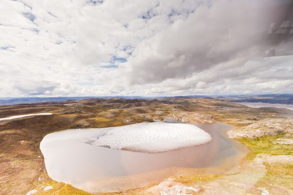
For much of the Pleistocene — the icy period covering the last 2.6 million years — portions of the ice on Greenland persisted even during warmer spells called “interglacials.” But most of this general story has been pieced together from indirect evidence in mud and rock that washed off the island and was gathered by offshore ocean drilling. The extent of Greenland’s ice sheet and what kinds of ecosystems existed there before the last interglacial warm period — that ended about 120,000 years ago — have been hotly debated and poorly understood.
The new study makes clear that the deep ice at Camp Century — some 75 miles inland from the coast and only 800 miles from the North Pole — entirely melted at least once within the last million years and was covered with vegetation, including moss and perhaps trees. The new research, supported by the National Science Foundation, lines up with data from two other ice cores from the center of Greenland, collected in the 1990s. Sediment from the bottom of these cores also indicates that the ice sheet was gone for some time in the recent geologic past.
Most of Greenland is covered with ice today. But a new study shows that the deep ice at a site called Camp Century in northwestern Greenland entirely melted at least once within the last million years. The research suggests that the landscape may have instead been covered with green tundra, perhaps like this view of eastern Greenland, near the ocean.
The combination of these cores from the center of Greenland with the new insight from Camp Century in the far northwest gives researchers an unprecedented view of the shifting fate of the entire Greenland ice sheet.
The team of scientists used a series of advanced analytical techniques — none of which were available to researchers fifty years ago — to probe the sediment, fossils, and the waxy coating of leaves found at the bottom of the Camp Century ice core. For example, they measured ratios of rare forms — isotopes — of both aluminum and the element beryllium that form in quartz only when the ground is exposed to the sky and can be hit by cosmic rays. These ratios gave the scientists a window into how long rocks at the surface were exposed vs. buried under layers of ice. This analysis gives the scientists a kind of clock for measuring what was happening in Greenland in the past.
Another test used rare forms of oxygen, found in the ice within the sediment, to reveal that precipitation must have fallen at much lower elevations than the height of the current ice sheet, “demonstrating ice sheet absence,” the team writes.
Combining these techniques with studies of luminescence that estimate the amount of time since sediment was exposed to light, radiocarbon-dating of bits of wood in the ice, and analysis of how layers of ice and debris were arranged — allowed the team to be clear that most, if not all, of Greenland, melted at least once during the past million years — making Greenland green with moss and lichen, and perhaps with spruce and fir trees.
And the new study shows that ecosystems of the past were not scoured into oblivion by ages of glaciers and ice sheets bulldozing overtop. Instead, the story of these living landscapes remains captured under the relatively young ice that formed on top of the ground, frozen in place, and holds them still.
In a 1960’s movie about Camp Century created by the Army, the narrator notes that “more than ninety percent of Greenland is permanently frozen under a polar ice cap.” This new study makes clear that it’s not as permanent as we once thought. “Our study shows that Greenland is much more sensitive to natural climate warming than we used to think — and we already know that humanity’s out-of-control warming of the planet hugely exceeds the natural rate,” says Christ.
“Greenland may seem far away,” says UVM’s Paul Bierman, “but it can quickly melt, pouring enough into the oceans that New York, Miami, Dhaka — pick your city — will go underwater.”
An 8,000-Year-Old Platform in Britain Could be the Oldest Boat-building site Ever
The Maritime Archaeological Trust has discovered a new 8,000-year-old structure next to what is believed to be the oldest boat building site in the world on the Isle of Wight.
Director of the Maritime Archaeological Trust, Garry Momber, said: “This new discovery is particularly important as the wooden platform is part of a site that doubles the amount of worked wood found in the UK from a period that lasted 5,500 years.”
The site lies east of Yarmouth, and the new platform is the most intact, wooden Middle Stone Age structure ever found in the UK.
The 8,000-year-old wooden platform following reconstruction.
The site is now 11 meters below sea level and during the period there was human activity on the site, it was dry land with lush vegetation. Importantly, it was at a time before the North Sea was fully formed and the Isle of Wight was still connected to mainland Europe.
The site was first discovered in 2005 and contains an arrangement of trimmed timbers that could be platforms, walkways or collapsed structures.
However, these were difficult to interpret until the Maritime Archaeological Trust used state of the art photogrammetry techniques to record the remains. During the late spring, the new structure was spotted eroding from within the drowned forest.
The first task was to create a 3D digital model of the landscape so it could be experienced by non-divers. It was then excavated by the Maritime Archaeological Trust during the summer and has revealed a cohesive platform consisting of split timbers, several layers thick, resting on horizontally laid round-wood foundations.
Garry continued “The site contains a wealth of evidence for technological skills that were not thought to have been developed for a further couple of thousand years, such as advanced woodworking. This site shows the value of marine archaeology for understanding the development of civilization.
Yet, being underwater, there are no regulations that can protect it. Therefore, it is down to our charity, with the help of our donors, to save it before it is lost forever.”
The Maritime Archaeological Trust is working with the National Oceanography Centre (NOC) to record and study, reconstruct and display the collection of timbers. Many of the wooden artefacts are being stored in the British Ocean Sediment Core Research facility (BOSCORF), operated by the National Oceanography Centre.
As with sediment cores, ancient wood will degrade more quickly if it is not kept in a dark, wet, and cold setting. While being kept cold, dark, and wet, the aim is to remove salt from within wood cells of the timber, allowing it to be analysed and recorded.
This is important because archaeological information, such as cut marks or engravings, are most often found on the surface of the wood and are lost quickly when timber degrades. Once the timbers have been recorded and have desalinated, the wood can be conserved for display.
Dr Suzanne Maclachlan, the curator at BOSCORF, said “It has been really exciting for us to assist the Trust’s work with such unique and historically important artefacts. This is a great example of how the BOSCORF repository is able to support the delivery of a wide range of marine science.”
When diving on the submerged landscape Dan Snow, the history broadcaster and host of History Hit, one of the world’s biggest history podcasts, commented that he was both awestruck by the incredible remains and shocked by the rate of erosion.
Historian Dan Snow inspecting the 8,000-year-old wooden platform off the coast of the Isle of Wight, UK.
This material, coupled with advanced woodworking skills and finely crafted tools suggests a European, Neolithic (New Stone Age) influence. The problem is that it is all being lost. As the Solent evolves, sections of the ancient land surface are being eroded by up to half a metre per year and the archaeological evidence is disappearing.
Research in 2019 was funded by the Scorpion Trust, the Butley Research Group, the Edward Fort Foundation, and the Maritime Archaeology Trust. Work was conducted with the help of volunteers and many individuals who gave their time and often money, to ensure the material was recovered successfully.
Decorative Roof Tiles from Tang Dynasty Temple Analyzed
According to a statement released by Kanazawa University, researchers from Kanazawa University and the Chinese Academy of Social Sciences examined the end caps of more than 400 curved roof tiles recovered from Ximing Temple, which is located at the site of the Tang Dynasty (A.D. 618–907) imperial capital in central China.
Any visitor to China will have noticed the spectacular roofs on buildings dating from imperial times. However, the question of how these roof tiles were produced has attracted relatively little attention from archaeologists.
Now, a team of researchers has conducted a major study of tile ends unearthed at the Ximing Temple in Xi’an, yielding exciting insights into their production.
In a study published in Archaeological Research in Asia, researchers from Kanazawa University and the Chinese Academy of Social Sciences have revealed the significance of minute variations in the tile ends used in the roof of the famous Ximing Temple in Xi’an, built during the Tang dynasty (618-907 AD) when Xi’an (then known as Chang’an) was the imperial capital.
The researchers conducted an investigation of 449 tile ends with lotus patterns from various periods during the Tang dynasty that had been recovered from the Ximing Temple.
Basic information about tile ends and imbrices. The figure shows the structure of a tile end and how tile ends and imbrices are used.
“We were interested in the variations in the tile ends, both those within the conscious control of the artisans who made the tiles, such as whether to use simple or complex lotus patterns and those outside their control, such as the marks left by the deterioration of the molds used to make the tiles,” says lead author of the study Meng Lyu.
“We discovered that the degree of minor variation in the tile ends increases significantly in the later samples,” adds author Guoqiang Gong.
“This suggests to us that there was a shift away from the centralized manufacturing of imperial building materials during the Early Tang period toward one in which small private artisans played an important role in the Late Tang period.”
Intriguingly, the study has revealed traces of the coming together of two distinct cultural traditions. “We found that there were, in fact, two separate production systems at work to make the title ends,” notes author Chunlin Li.
“One produced tile ends with compound petal patterns and curved incisions, whereas the other made end tiles with simple petal patterns and scratched incisions.”
These two styles may ultimately have their origins during an earlier historical period when the Northern Wei dynasty was divided into two regimes on either side of the Taihang mountain range.
This study demonstrates that studying the roof tiles of China’s grand imperial buildings can reveal a great deal about the circumstances of their production and yield insights into larger historical questions.
2,700 Year Old Yogi in Samadhi Found in Indus Valley Civilization Archaeological Site
While Yoga is being sold by Corporate Gurus today, it is necessary to remember that Yoga as a system of Spiritual development was in vogue probably by or before the Rig Veda which is dated around 5000 BC.
However, I have provided information that the Vedas date back much earlier, going back to at least 75000 years. While there is no specific reference to Yoga is found in the Vedas, Yoga seems to have been in vogue during that period or earlier.
And while Shiva is not mentioned in detail in the Vedas the Tamil literature speaks of Him. Evidence about Thiruvannamalai in Tamil Nadu is 3.94 Billion years and Jwalapuram in Telangana, India being 74000 years old has come to light.
Lord Shiva.
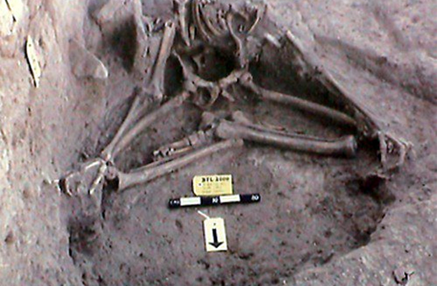
The 2,700-year-old skeletal remains of an ancient yogi sitting in samadhi have been found in an Indus valley civilization archaeological site located at Balathal, Rajasthan.
Many Indus Valley seals depict pictures of yogis sitting in the lotus position. Here are two examples showing ancient yogis sitting in meditation and keeping their hands on their knees as done in modern yoga meditations. If we see the skeletal remains of the yogi above, we can note that his fingers are in gyana mudra (with the thumb touching index finger), resting on his knees as well.
Yogi Remains in Baithal, Padmasana and with Gyan Mudra
Balathal is an archaeological site located in Vallabhnagar tehsil of the Udaipur district of Rajasthan state in western India. This site, located 6 km from Vallabhnagar town and 42 km from Udaipur city, was discovered by V. N. Misra during a survey in 1962-63. Excavation began in 1994 jointly by the Department of Archaeology of the Deccan College Post-graduate and Research Institute, Pune and the Institute of Rajasthan Studies, Udaipur.
Excavation of sites from the 4,500-year-old Ahar culture provide clues to the link between the Harappans and their predecessors. That it existed at all was a surprise – a fortified enclosure of mud and brick, comparable to the citadels of the Harappans, spread over 500 sq m. It was filled with ash and cow dung. A people called the Ahars had built it in Balathal near modern Udaipur some 4,500 years ago.
Carbon dating established that they had lived in and around the Mewar region in Rajasthan between 3,500 and 1,800 B.C. They were Mewar’s first farmers, older even than the Harappans. But why had they built a fort only to fill it with ash and cow dung? To solve the mystery, a team of Indian archaeologists excavating the site went on removing layer after layer of civilisation.
The mystery deepened. They found five skeletons, four in layers between 2,000 B.C. and 1,800 B.C. That was the age of stone and copper, the chalcolithic age. This was the first time human skeletons had been found at any Ahar site. The Ahars, it had been thought, cremated their dead. And the Harappans buried theirs.
There are 90 sites of Ahar – a rural society. The recent round of excavations is establishing that Ahar culture and Harappan civilisation were different though contemporary and related. This village life emerged much before the mature Harappan era.
Harappa’s progress in the mature Harappan period (2,500 B.C.) helped the rural Ahar people to flourish and develop their own township and stone and brick houses. On the scale of civilisation, they emerged far ahead of other chalcolithic cultures in the subcontinent.
And they may be the missing link to show how the Indus people made such a quantum leap from small rural communities to an advanced civilisation.
Ahar culture flourished predominantly in the Mewar region of Rajasthan, on the eastern side of the Aravallis, and in undulating rocky plateaus and plains along the Banas River and its tributaries.
In modern Rajasthan, Ahar sites have been reported in Udaipur, Chittorgarh, Dungarpur, Bhilwara, Rajsamand, Bundi, Tonk and Ajmer dotting10,000 sq km. “There is a commonality in all 90-sites located in Southeastern Rajasthan and parts of Madhya Pradesh,” says Jaipur-based Rima Hooja, a scholar on Ahar culture.
Their name comes from a mid-1950s excavation led by R.C. Aggarwal, former director of archaeology, Rajasthan, at Ahar near Udaipur. A few years later, one excavation was carried out at Gilund in Rajsamand and then the focus shifted to the Harappans.
The Deccan College, Pune and Institute of Rajasthan Studies, Rajasthan Vidyapeeth, Udaipur turned their attention to Ahar culture in 1994 and began excavations in Balathal. Deccan College and the University of Pennsylvania began digging in Gilund in 1999 and the Jaipur circle of Archaeological Survey of India (ASI) began excavation at Ojiyana in Bhilwara in 2000. And discoveries began pouring in.
Gwen Robbins, a biological anthropologist from the University of Oregon, USA, in her ongoing preliminary analysis of the bones, found the first skeleton uncovered was of a male. Dead at the age of 50, he suffered from joint disease and had lost all but four of his teeth at least five years before death. On closer inspection of the remains, a left mandible and a few cranial fragments were found to be of a second individual aged 35 whose sex couldn’t be determined.
The third skeleton was of a female approximately 35 years of age. The fourth was of a 35-year-old woman, and it caught the archaeologists’ interest. It had been buried with a small earthen lota (pot) near the head. Why was the lota there? “I am certain that the fortified enclosure had a ritual function,” says Dr V.N. Mishra, former principal of the Deccan College, who led the excavations: “You don’t find such selective burials in cow dung and ash anywhere else.”
The fifth skeleton, from a different era, was of an adult male 35 to 40 years old and had been buried in a seated position that resembles the modern samadhi burial of sadhus who renounce the world. The ritual of burial in ash and cow dung raises the need to look at related traditions in present-day Hindu communities such as Gosain and Jogi which bury their dead.