This abandoned site was once the ‘City of 1,001 Churches’

This abandoned site was once the ‘City of 1,001 Churches’

You know that heavy feeling you get when you see an ancient site or ruin and can almost feel all the lives that have passed through it and try to imagine it in all its former glory? Well, look no further than Ani, a medieval Armenian city on the Turkish border, deemed worthy of being called a treasure of world cultural heritage when UNESCO recognized it as such in the early hours of July 15, 2016.

Once a hustling and bustling commercial center on a branch of the ancient Silk Road, sitting at the crossroads of other trade routes that flowed into the heart of Anatolia, Ani now lies off the beaten track – deserted and exotic in all its remoteness.

As with many other important archaeological sites, Ani, too, was built high on a secluded hilltop on fertile volcanic tuff, not far from a nearby water source. With deep-running gorges to its east and west that acted as natural borders and a great defense, the area was the perfect place to call home, once upon a time.

The Monastery of the Hripsimian Virgins, in the ruins of the city of Ani,The monastery is thought to have been built between 1000 and 1200 AD, near the height of Ani’s importance and strength. The Akhurian River below acts as the modern border between Turkey and Armenia.

The first people to settle in the area did so around 3000 B.C., setting up camp on the banks of the emerald green Akhurian River (locally known as Arpaçay).

From the outside, the city seems like a fortress to many, with majestic walls saluting visitors, their sheer expanse growing ever-so overwhelming upon entrance through the Lion Gate but inside lies a different world.

If you were expecting perfectly preserved grandiose buildings that have stood the test of time, you are likely to be very disappointed. Time, nature, earthquakes, and people through wars and invasion have not been kind to Ani, and it shows. It is run down, it is forgotten but that’s what makes it different. It reeks of history. It carries that daunting air that makes you question your very existence, with the ruins of the city crumbling under the heaviness of all the countless experiences of Saka Turks, Sassanids, the Byzantines, Georgian Atabegs, Seljukians, Ottomans, and Russians, just to name a few.

It is deemed a “world city” and the cradle of civilizations and rightly so – it bore witness to 23 civilizations and dynasties throughout the centuries.

Ani saw its best times and expanded greatly when it became the capital of the Bagratid Kingdom of Armenia in the 10th and 11th centuries, growing to a population of about 200,000 at its peak, much larger than London at the time.

The ancient city shows its multicultural fabric in every square inch. From the Seljuk geometric wall patterns to frescoes and elaborate carvings, the influences of Armenian pagan rituals as well as Christian and Muslim religious traditions are evident in the city of tolerance.

Still a hidden gem

The city exudes authentic beauty throughout all of the seasons. In winter, under a blanket of pristine snow, it looks like a long-lost frozen kingdom, in autumn it looks mystique and broody, hiding secrets awaiting to be discovered.

Once warmer weather comes round, it almost springs back to life, growing more verdant with every raindrop and filling you up with a sense of adventure that doesn’t come with many historic European sites choked by hordes of tourists.

Thanks to its remote location, once you step in the ruins, it gives you this rush that makes you feel like you’re the first people to (re)discover such profound age in a long time.

All the structures in Ani were built using local volcanic basalt, which was easy to carve, a functional insulator, and came in many vibrant colors such as rosy reds and jet blacks. Not all of the buildings are situated on the central route used by guides or explorers nor are they easily accessible, and the usual half-day trips give you nowhere near enough time to explore every single one scattered across the plateau. So if you’d like to take it all in, it’s best to set aside a few days.

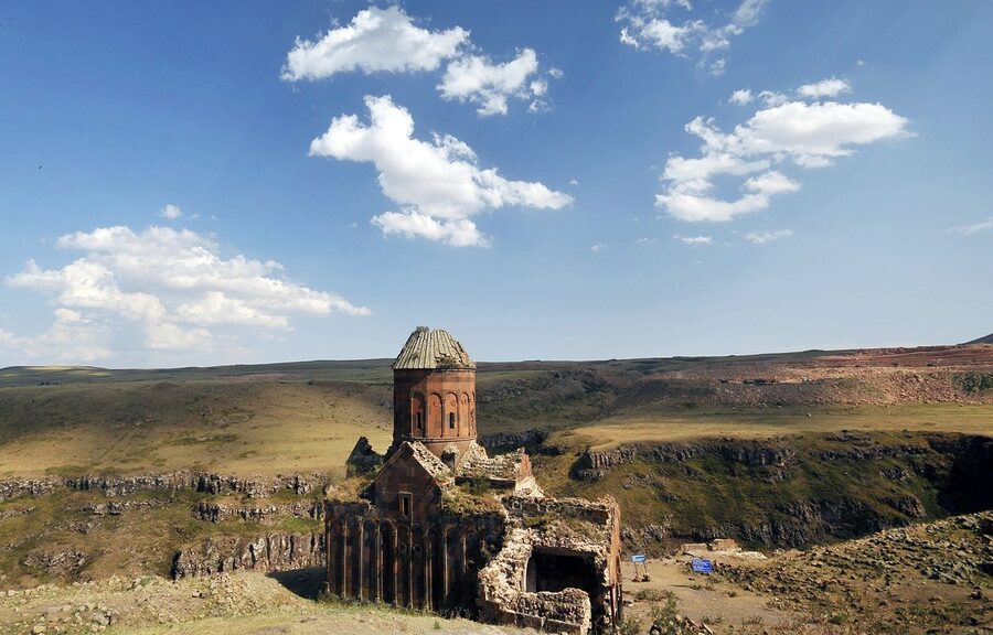
The largest building standing in Ani is the cathedral. A rather Gothic looking structure with novel features such as pointed arches and a now nonexistent dome, the cathedral is an impressive piece of Armenian architecture.

Its importance as a house of God was preserved even when it changed hands throughout history, becoming the first place where Muslim prayers were held in Anatolia after the Seljuk’s momentous victory in the Battle of Manzikert (1071), which opened up the gates of Anatolia to the Turks.

The cathedral, however, was greatly damaged in a devastating earthquake in 1319 as well as during the Mongol invasion, events that marked the beginning of the city’s great decline. By the time the 17th century rolled around, the city was left desolate.

There are numerous other sanctuaries and structures in the city that shed light on the past. The Ebul Menucehr Mosque, the first Turkish mosque on Anatolian soil, the churches of Amenaprgich (the Holy Savior Cathedral), Tigran Honentz (the Church of St. Gregory) and Abugamir Pahlavuni (the Church of the Holy Redeemer), in addition to countless monasteries and chapels dotting the vast meadows, are just a few that have contributed to Ani’s historical reputation.

The ruined church of the Holy Redeemer

And as if you needed another excuse to catch the nostalgic Eastern Express, to embark on your journey to the ancient archaeological site of Ani all you need is to hop on that train from Ankara. Once you arrive in Kars’ city center, it’s up the hills we go by car or bus, over bends and rocks for about 42 kilometers, passing flocks of sheep and herds of cows, where the famous Kars gruyere comes from, slowly leaving behind city life to step back in time.

Oldest fossils on Earth discovered in 3.7bn-year-old Greenland rocks

Oldest fossils on Earth discovered in 3.7bn-year-old Greenland rocks

According to recent research, tiny sediment ripples on an ancient seafloor, captured inside a 3.7 billion-year-old rock in Greenland, possibly the earliest fossils of living organisms ever found on Earth.

The research, led by Allen Nutman, head of the School of Earth and Environmental Sciences at the University of Wollongong in Australia, described the discovery of what looks like tiny waves, 0.4 to 1.5 inches (1 to 4 centimeters) high, frozen in a cross-section of the surface of an outcrop of rock in the Isua Greenstone Belt in southwestern Greenland, a formation made up of what geologists regard as the oldest rocks on the Earth’s surface.

The researchers said the ripples are the fossilized remains of cone-shaped stromatolites, layered mounds of sediment, and carbonates that build up around colonies of microbes that grow on the floor of shallow seas or lakes. 

According to the scientists, the new discovery, detailed online today in the journal Nature, supports theories that life on Earth originated during the so-called Hadean eon more than 4 billion years ago, a period of intense volcanic activity when large meteorites and icy comets frequently bombarded Earth. This was also the time when the first bodies of water formed on the planet’s surface.

The rock outcrop was found only after a series of warm summers in southwestern Greenland caused large patches of snow at the site to melt earlier than normal, revealing rocks that had not been examined by researchers since the Isua Greenstone Belt was first explored in the 1980s, Nutman told Live Science.

The stromatolites in figure a are from Greenland; those in c and d are younger stromatolites from Western Australia. Figure b shows the layers created by microbes as they formed the Greenland stromatolites (blue lines). ‘Storms’ are several overlapping stromatolites.

“Most of the rocks there are very deformed and modified by later mountain-building processes, but you do find just very tiny little areas that have survived with their original volcanic or sedimentary structures not destroyed,” Nutman said. “But this is the first one of the surviving structures where we actually have stromatolites.”

Under pressure

Remarkably, the structures were found in an outcrop of metamorphic rock that was once subject to intense underground heating and pressure, which distorted their original shapes and changed their chemical composition.

Allen Nutman (left) and Vickie Bennet (right) with a specimen of 3.7-billion-year-old stromatolites from Isua, Greenland

“The overall features, such as the shape of the stromatolites, are preserved,” Nutman said. “But some of the finer details of the very fine layering have certainly been erased — although, as we show in the paper, there are vestiges of that left.”

Sediment structures that look like stromatolites can form without the involvement of microbial life, but the researchers said they examined the chemistry and minerals in the rocks and were able to establish that they contain the fossilized remains of a colony of ancient microbes.

The 3.7-billion-year-old structures described in the new study are about 220 million years older than the fossils previously regarded as the oldest known fossils on Earth. Those 3.5-billion-year-old stromatolites, found in sedimentary rocks in Western Australia, precipitated over billions of years without metamorphic heating. Abigail Allwood, an astrobiologist at NASA’s Jet Propulsion Laboratory in Pasadena, California, whose 2006 study about the Australian fossils established their biological origin, said the new study will likely face close scrutiny. 

“These kinds of discoveries always do [cause controversy], especially when they first come out, and in this case, it’s particularly amazing because they were found in metamorphic rocks that have been significantly altered and transformed from their original characteristics,” Allwood told Live Science.

Allwood reviewed the new study by Nutman and his colleagues for a separate opinion piece published in the journal Nature. Allwood’s 2006 study is cited in the new paper, but she did not contribute directly to the latest research.

“It’s remarkable that they have found [the structures], and they’ve done a good job of analyzing what’s there — but the alteration that the rocks have seen means that there’s just a whole lot of stuff that you’d typically like to see to make such an extraordinary claim, that just isn’t preserved,” she said.

Life or nonlife?

Geochemist Balz Kamber, chair of geology and mineralogy at Trinity College Dublin in Ireland, has also studied the stromatolite fossils from Western Australia. He told Live Science that the new finds would no doubt face further scientific tests to assess the strength of the claims for a biological origin. But he added that the new structures appear to be a far better prospect for evidence of ancient life than another set of fossils reported nearly two decades ago on Greenland’s Akilia Island, which were later shown not to have a biological origin.

Kamber also said there can be little doubt that the conical structures identified in the new research are the result of sedimentation on the floor of a marine environment, regardless of whether they can be shown to have a biological origin. This means that the structures are not only evidence of standing bodies of water on the Earth’s surface 3.7 billion years ago, but also bodies of land crossed by rivers that carried chemical solutes into the ancient oceans, he said.

Both Kamber and Allwood also said the new findings have implications for the field of astrobiology and the search for evidence of past life on other planets — particularly on Mars. Kamber said these potential clues about the very early emergence of life on Earth in the Hadean period supports his own recent research, published earlier this year, about the prospects for life in the water-filled craters caused by meteorite and comet impacts on the early Earth.

“I think the enclosed impact basins at the tail end of the bombardment at 3.8 [billion] to 3.85 billion years ago would have made great places for life to emerge from,” he said.

Allwood added that there is also clear evidence that, at the time the rocks at Isua were forming 3.7 billion years ago, conditions on Mars were similar to those on early Earth.

“[T]here were similar environments in bodies of water standing at the surface of Mars, offering a similar kind of environment to the ones that hosted the early evidence of life on Earth, at Isua and younger,” she said.

Until now, there had been a gap between the start of the fossil record on Earth and the youngest areas on Mars, where there was good evidence for standing bodies of water in the past.

“And you had to imagine that life could have arisen there before they dried up — but now at least we may have one example in the fossil record showing us that life can arise that quickly,” Allwood said.

5,000-year-old Bryde’s whale skeleton unearthed in Thailand

5,000-year-old Bryde’s whale skeleton unearthed in Thailand

An unusual, partly fossilized skeleton belonging to a Bryde whale, estimated to be about 5,000 years old, has been discovered by researchers in Thailand at an inland site west of Bangkok.

At the beginning of November, a skeleton weighing 12.5 meters (41ft), about the length of a truck, was discovered by a cyclist who saw some of the vertebrae coming out of the ground.

Since then, a team of scientists has been excavating the site.

Scientists say the bones need to be carbon-dated to determine the exact age of the skeleton

“This whale skeleton is thought to be the only one in  Asia,” said Pannipa Saetian, a geologist in the Fossil Protection division of the Department of Mineral Resources.

“It’s very rare to find such a discovery in near-perfect condition,” said Pannipa, estimating that about 90 percent of the whale’s skeleton had been recovered.

“Yesterday, we found the right shoulder and fin,” she said, noting that about 36 backbone pieces had been unearthed. The bones needed to be carbon-dated to determine the exact age of the skeleton, she said.

An archaeologist works at the excavation site at Samut Sakhon on Friday.

Once the painstaking process of cleaning and preserving the fragile skeleton is complete, it will be exhibited.

Scientists hope the skeleton will provide more information to aid research into Bryde’s whale populations existing today as well as the geological conditions at the time.

Bryde’s whales, sometimes known as tropical whales for their preference for warmer waters, are found in coastal waters in parts of the Indian, Pacific, and Atlantic Oceans, including in the Gulf of Thailand.

Highly endangered, there are some 200 remaining of the whales in the South Pacific nation’s waters, and about 100,000 worldwide.

In 2016, New Zealand researchers gained insight into a pair of Bryde’s whales feeding off an  Auckland coast in one of the first uses of drone technology to study the animals.

The footage revealed an adult and calf frolicking in the water and using a “lunge” feeding technique to feast on plankton and shoals of small fish.

In 2014, a 10.8-meter-long whale thought to be a Bryde’s whale, washed up at a remote beach in Hong Kong’s New Territories.

Conservationists said it could have died at sea before drifting to an 
the inner bay off Hung Shek Mun, in Plover Cove Country Park.

Archaeologists discover a Perfectly Preserved 4,000-year-old tomb in Egypt

Archaeologists discover a Perfectly Preserved 4,000-year-old tomb in Egypt

Archeological finds in Egypt never stop. This was made all the more apparent by the recent discovery in Saqqara of a vibrant tomb, home to some of the oldest pyramids in Egypt.

There are vivid wall paintings in the amazingly well-preserved tomb that look like they were made yesterday when in reality the tomb was created over 4,000 years ago.

To celebrate the discovery, Prof. Khaled al-Enani—Egypt’s Minister of Antiquities—recently led over 50 foreign dignitaries on a tour through the site.

Archaeologists discover a Perfectly Preserved 4,000-year-old tomb in Egypt
Mohamed Mujahid, head of the Egyptian mission which discovered the tomb of the ancient Egyptian nobleman “Khewi”, takes a selfie. The tomb at the Saqqara necropolis dates back to the 5th dynasty (2494-2345 BC).

It’s believed that the tomb, which is located within a large necropolis, was created during the Fifth Dynasty.

This period spanned the early 25th century BCE until the mid 24th century BCE and was known as a time when funerary prayers began to be inscribed on royal tombs. In this particular case, the exceptional tomb was created for a dignitary named Khuwy.

Several aspects of the tomb lead researchers to believe that Khuwy was a man of great importance. Architecturally, it has a tunneled entrance, which is a feature typically reserved for pyramids—the tombs of the pharaohs.

Artistically, the colors of the paintings are considered “royal colors” by officials. These clues bring into question Khuwy’s influence and his relationship with the Fifth Dynasty’s longest-ruling pharaoh, Djedkare Isesi.

Step Pyramid at Saqqara

Djedkare’s pyramid is located nearby in Saqqara and one theory is that Khuwy was a relative of the leader.

Others believe that the lavishness of the tomb was instead owed to the Djedkare’s reforms on funerary cults. Whatever the cause, what we’re left with are incredible examples of the artistry of ancient Egypt.

In addition to the tomb decoration, archaeologists also found Khuwy’s mummy and canopic jars—used to hold organs—scattered in several fragments.

Egyptologists hope that the newly discovered tomb will give them more insight into Djedkare’s reign, as the pharaoh’s own tomb was raided prior to excavation in the 1940s.

While Djedkare appeared to be held in high regard even after his death—he was the object of a cult until at least the end of the Old Kingdom—he is still a somewhat enigmatic leader.

Israeli Archaeological Dig Uncovers 9,000-year-old Mega City

Israeli Archaeological Dig Uncovers 9,000-year-old Mega City

The largest ever Neolithic settlement discovered in Israel and the Levant, say archaeologists  — is currently being excavated ahead of highway construction five kilometres from Jerusalem.

Because of its scale and the preservation of its material culture, the 9,000-year-old site, situated near the town of Motza, is the ‘Big Bang’ for prehistory settlement research, said Jacob Vardi, co-director of the excavations at Motza on behalf of the Antiquities Authority,

Vardi said It’s a game-changer, a site that will shift what we know about the Neolithic era drastically.” He said that some international scholars are beginning to realize the existence of the site may necessitate revisions to their work, he said.

“So far, it was believed that the Judea area was empty and that sites of that size existed only on the other bank of the Jordan river, or in the Northern Levant. Instead of an uninhabited area from that period, we have found a complex site, where varied economic means of subsistence existed, and all these only several dozens of centimeters below the surface,” according to Vardi and co-director Dr. Hamoudi Khalaily in an IAA press release.

Roughly half a kilometer from point to point, the site would have housed an expected population of some 3,000 residents. In today’s terms, said Vardi, prehistoric Motza would be comparable to the stature of Jerusalem or Tel Aviv — “a real metropolis.”

According to an IAA press release, the project was initiated and financed by the Netivei Israel Company (the National Transport Infrastructure company) as part of the Route 16 Project, which includes building a new entrance road to Jerusalem from the west running from the Route 1 highway at the Motza Interchange to the capital.

According to co-director Khalaily, the people who lived in this town had trade and cultural connections to widespread populations, including Anatolia, which is the origin for obsidian artifacts discovered at the site. Other excavated materials indicate intensive hunting, animal husbandry, and agriculture.

Dr. Hamoudi Khalaily, Antiquities Authority Excavation director at the Motza site, holding a bowl from the Neolithic Period.

“The society was at its peak” and appeared to increasingly specialize in raising sheep, said Khalaily.

In addition to prehistoric tools such as thousands of arrowheads, axes, sickle blades, and knives, storage sheds containing large stores of legumes, especially lentils, were uncovered. “The fact that the seeds were preserved is astonishing in the light of the site’s age,” said the archaeologists.

Archaeologists recovered thousands of flint tools crafted by early farmers, such as sickles to harvest crops and arrowheads for hunting and warfare.

Alongside utilitarian tools, a number of small statues were unearthed, including a clay figurine of an ox and a stone face, which Khalaily joked was either a human representation “or aliens, even.”

9,000-year-old figurine of an ox, discovered during archaeological excavations at Motza near Jerusalem.

In the ancient, unrecorded past as well as today, the site is situated on the banks of Nahal Sorek and other water sources. The fertile valley is on an ancient path connecting the Shefela (foothills) region to Jerusalem, said the IAA. “These optimal conditions are a central reason for long-term settlement on this site, from the Epipaleolithic Period, around 20,000 years ago, to the present day,” according to the press release.

“Thousands of years before the construction of the pyramids, what we see in the neolithic period is that more and more populations turn to live in a permanent settlement,” said Vardi. “They migrate less and they deal more and more in agriculture.”

Among the architecture uncovered in the excavation are large buildings that show signs of habitation, as well as what the archaeologists identify as public halls and spaces used for worship. In a brief video published by the IAA, archaeologist Lauren Davis walks a narrow path between remains of buildings — a prehistoric alleyway. “Very much like we see in buildings today, separated by alleys between,” said Davis.

Israeli Archaeological Dig Uncovers 9,000-year-old Mega City
Excavation works on the Motza Neolithic site

According to the archaeologists, this alleyway is “evidence of the settlement’s advanced level of planning.” Likewise, the archaeologists discovered that plaster was sometimes used for creating floors and sealing various facilities during the construction of the residents’ domiciles and buildings.

In addition to signs of life, the archaeologists uncovered several graves. According to Davis, in the midst of a layer dating to 10,000 years ago, archaeologists found a tomb from 4,000 years ago. “In this tomb are two individuals — warriors — who were buried together with a dagger and a spearhead,” she said.

“There’s also an amazing find,” said Davis, “which is a whole donkey, domesticated, that was buried in front of the tomb probably when they sealed it.” Added Vardi, the donkey was apparently meant to serve the warriors in the world to come.

According to Amit Re’em, the IAA’s Jerusalem District archaeologist, despite the roadworks, a significant percentage of the prehistoric site around the excavation is being preserved and all of it is being documented.

Each architectural structure is being documented through 3-D modeling. “When we finish the excavation here,” said Vardi, “we will be able to continue to research the site in the laboratory,” adding that this is an unprecedented use of technology.

“In addition, the IAA plans to tell the story of the site at the site by means of a display and illustration. At Tel Motza, adjacent to this excavation, archaeological remains are being preserved for the public at large, and conservation and accessibility activities are being carried out in Tel Bet Shemesh and Tel Yarmut,” announced the IAA release.

The miniature Sculpture of a bird was Carved 13,500 years ago

The miniature Sculpture of a bird was Carved 13,500 years ago

A miniature bird statue carved out of burnt bone has been unearthed by archaeologists in Lingjing, China. At over 13,000 years it is believed to be the oldest East Asian work of art ever found.

Humans have been creating sculptures since the Upper Paleolithic period (50,000 to 12,000 years ago), the earliest being a lion-headed human carved from mammoth tusk found in German caves, dating back 35,000-40,000 years.

This bird figurine shows that sculpture was emerging independently in East Asia during the same period.

Discovered by a team of archaeologists led by Prof Francesco d’Errico at the University of Bordeaux, France, the 2cm-long bird is incredibly well-preserved, with a short neck, rounded bill and long tail, and a pedestal so that it can stand up.

The sculpture is thought to represent a ‘passerine’ – a diverse group of birds that includes the sparrows, finches and thrushes.

Photo (top) and 3D reconstruction using microtomography (bottom) of the miniature bird sculpture.

The researchers analysed the bird using microscopy and X-ray scanning, determining that it was carved from a mammal limb bone that had been blackened by heating.

They also painstakingly reconstructed the sculpting process: the bird was created using four different techniques – gouging, abrading, scraping, and incising.

“Our analysis reveals that the Lingjing artist has chosen the appropriate techniques and applied them skillfully to faithfully reproduce the distinct anatomical features of a passerine,” they write.

“The style of this diminutive representation is original and remarkably different from all other known Paleolithic avian figurines.”

The researchers estimate the figurine to be 13,500 years old – more than 8,500 years older than other animal sculptures found in East Asia.

World War II–Era Code Machine Recovered from Baltic Sea

World War II–Era Code Machine Recovered from Baltic Sea

From the bottom of the Baltic Sea in Europe, three-quarters of a century after it was lost at the end of the Second World War, one of the most famous puzzles on the planet has been recovered.

A mechanical encryption device that once confounded the Allies while allowing Adolf Hitler’s Nazis to make battle plans in secret, German divers say they have dredged up a long-lost Enigma machine.

The typewriter-like machine was found on the seafloor of Gelting Bay in northeast Germany, where divers were working to collect old fishing nets on behalf of the World Wildlife Federation.

The Enigma cipher machine was discovered on the seabed in Gelting Bay near Flensburg, Germany.

It’s believed the Nazis tossed the device overboard in an attempt to destroy it in the final days of the war, as part of an effort to keep German technology out of the Allies’ hands.

Divers initially thought the object was an old typewriter, but underwater archaeologist Florian Huber says he recognized it after it was brought up to the surface.

“I’ve made many exciting and strange discoveries in the past 20 years,” he told Reuters. “But I never dreamed that we would one day find one of the legendary Enigma machines.”

While searching for abandoned fishing nets, German divers discovered this Enigma machine in the Baltic Sea.

The Enigma machine was essentially an encrypted typewriter that allowed the Germans to send and receive messages without fear of them being intercepted and decoded by the enemy.

The Nazis used the machines to coordinate their war efforts for years, thanks to a shifting encryption process that would change every 24 hours.

British cryptographers worked tirelessly to decode the encrypted messages at Bletchley Park.

Legendary mathematician Alan Turing is widely credited with finally cracking the code in 1941, which allowed the Allies to spy on German communications in the latter days of the war. The breakthrough came after Britain seized an Enigma machine from a captured German sub.

The codebreakers’ work is thought to have helped end the war and save thousands of lives. It also inspired the Oscar-nominated film The Imitation Game in 2014.

Huber says the Enigma machine found in Gelting Bay was likely lost in May 1945, around the time that the Germans surrendered.

German forces were ordered to sink approximately 50 of their own submarines in Gelting Bay at the end of the war, in an effort to prevent the subs from being captured. Crews were also specifically instructed to destroy the Enigma machines on board.

“We suspect our Enigma went overboard in the course of the event,” said Huber, who works for an underwater research firm called Submarines.

The divers have decided to donate the device to a museum where it can be restored and put on display.

Surviving Enigma machines are rare in 2020, although examples can be found at museums scattered across the world, including Canada. The restoration process for the new discovery is expected to take about a year.

Carving on 5,000-year-old Sudan rock shows world oldest Place name

Carving on 5,000-year-old Sudan rock shows world oldest Place name

Wadi Al-Malik is the bed of an extinct river in Sudan that is rarely explored by archaeologists, but a recent dig has uncovered an incredible discovery – the world’s oldest ‘place-name sign.’

A team with the University of Bonn deciphered four hieroglyphs carved more than 5,000 years ago on a large stone that read ‘Domain of the Horus King Scorpion.’

What makes this inscription unique is the circular symbol toward the top right that indicates the rock was a marking of a ruler’s territory.

Archaeologists note that such writings in a remote area were unusual for those living in the fourth millennium BC, but it highlights the process of internal colonization in the Nile River

Egyptologist Prof. Dr Ludwig D. Morenz from the University of Bonn, said: ‘This ruler called ‘Scorpion’ was a prominent figure in the phase of the emergence of the first territorial state in world history.’

Carving on 5,000-year-old Sudan rock shows world oldest Place name
A team with the University of Bonn deciphered four hieroglyphs carved more than 5,000 years ago on a large stone that read ‘Domain of the Horus King Scorpion, making it the world’s oldest place name same

Morenz continued to explain that Scorpion lived around 3070BC, but the team has yet to determine the dates and length of his reign.

He told DailyMail.com in an email: ‘Around 3100 there started something completely new in the Nile Valley: the first territorial state (one political power reigning of a territory of more than 800km north-south).’ 

‘The ‘Scorpion’ I am talking about played an important role in this process (as the first territorial state in world history I think it is of high importance even for our understanding of ‘global history’).’

‘Furthermore, I think that with our findings in Wadi el-Malik we can get a better understanding of the internal socio-economic development of Egypt a bit more than 5000 years ago.’

The name ‘Scorpion’ is written together with three other hieroglyphs on a rock inscription discovered more than two years ago in Wadi Abu Subeira to the east of Aswan.

The team from the University of Boon collaborated with the Egyptian Ministry of Antiquities when the stone was discovered two years ago, with the hopes of deciphering the ancient drawings.

The name ‘Scorpion’ is written by what looks like the predatory arachnids, along with two other images. But in the top right corner is a circular design that reveals that stone is a place name sign

The name ‘Scorpion’ is written by what looks like the predatory arachnids, along with two other images. But in the top right corner is a circular design that reveals that stone is a place name sign.

‘This is precisely why the new discovery of the rock inscription is so valuable,’ Morenz said.

‘Despite its brevity, the inscription opens a window into the world of the emergence of the Egyptian state and the culture associated with it.’

The researchers explain that Egypt was the first territorial state worldwide. There were already ruling systems elsewhere before, but these were much smaller,’ said Morenz.

The name ‘Scorpion’ is written together with three other hieroglyphs on a rock inscription discovered more than two years ago in Wadi Abu Subeira to the east of Aswan

However, during this time it was popularly known that the north-south extension of Egypt was already nearly 500 miles.

In fact, several rival population centres merged into the new central state,’ says Morenz. Royal estates, known as domains, were founded on the periphery of the empire in order to consolidate the pharaonic empire.’ 

In addition to various rock carvings, other early rock inscriptions were discovered here and found together with pottery from this period. 

‘This area is still in the early stages of archaeological investigation,’ says Morenz.  The researchers see this as an opportunity to take a closer look at the momentous process of the world’s first state emergence.  

All In One Magazine