Evidence of Medieval Battle Discovered in Polish Forest
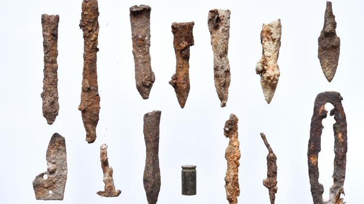
In a forest in Sanok, hundreds of arrowheads and crossbow bolts from a major battle with King Casimir the Great in the 14th century were found.
Archaeologists unearthed the huge find during an investigation to find out why the area was being plagued by illegal treasure hunters.
Biała Góra archeologists say they believe that they now locate Casimir’s Great campaign battleground in Red Ruthenia (formerly part of southeastern Poland and Ukraine).
Archeologists who were wondering why so many illegal treasure hunters flocked to a peak in Słonne Mountains and part of Sanok’s Wójtostwo district, decided to investigate
The hundreds of arrowheads and crossbow bolts come from the 14th century.
Already well-known for being the site of a medieval settlement, the last time it had been officially researched was 50 years ago.
Dr. Piotr Kotowicz from the Sanok Historical Museum told PAP: “We decided to use the same research method and invited the Galicia Historical and Exploratory Association’s representatives to work with us.
“The results of the research exceeded our wildest expectations. During several seasons, in the area around the fortified settlement, we found more than 200 arrowheads and bolts.”
It is still unclear who fought whom and why, but the archaeologists believe that the objects may be a sign of a 14th century battle between Polish and Ruthenian forces.
According to chronicles, in 1340 Casimir the Great with an army of 20,000 conquered several fortified settlements in the area. Kotowicz is convinced, that the latest findings in Sanok can be linked to that particular military campaign.
Shortly afterward, between 1340 and 1344, Red Ruthenia was incorporated into Poland permanently after the death of duke Bolesław – Jerzy II.
Dr. Kotowicz said: “It seems that the caves and bolts we discovered are a testimony of fights between Ruthenians and Poles.
“The analysis of the caves’ spread shows that most of them were concentrated in the stronghold’s area and right next to it.
“We also searched the area around it for ‘response’ to the attack. However, we did not find too many caves with weapons.
“This means that the defenders were dominated by the invaders and their response to the attack was minimal.”
The fortified settlement on Biała Góra was rather small, surrounded by one line of fortifications and dry moat. According to the recent findings, it was heavily damaged during the battle. The arrowheads and bolts weren’t the only surprises that awaited Dr. Kotowicz’s team.
In the area around the fortified settlement the archaeologists found more than 200 arrowheads and bolts.
A nearby patch of flattened land hid numerous artifacts of older origins – even from the 9th or 10th centuries. Among them is the first Arabic coin from the Middle Ages, dirham, found in Sanok.
Dr. Kotowicz believes that these are the remains of an industrial settlement, as evidenced by numerous cinders – iron ore was probably melted there.
Bizarre French inspiration of Stonehenge as slab origins confirmed
Some experts believe that the ancient monument was used as a cemetery for more than 500 years, and some suggest that it may be of spiritual importance, due to the encompassing horseshoe arrangement being aligned to the sunset of the winter solstice and the opposing sunrise of the summer solstice.
Up until now, all that archaeologists knew with reasonable certainty was that the stones had been brought in around 2500BC from the Marlborough Downs by the great temple’s Neolithic builders.
Now though, scientists from the University of Brighton have traced the stones to a very specific two square mile part of that range of hills — a patch of woodland just south of the village of Lockeridge, Wiltshire.
But, they may have taken inspiration from overseas.
A study published in the journal Proceedings of the National Academy of Sciences suggests an ancient culture that emerged from what is now the Brittany region of northwest France may have begun building these structures and monuments some 7,000 years ago.
Archaeologists believe Stonehenge builders took inspiration from France
Study author Bettina Schulz Paulsson of the University of Gothenburg in Sweden said that the megalith building probably began in France and spread from there via sea routes around Europe over the next 1,000 years or so.
For more than a decade, Dr. Paulson created a “megalith evolution” using radiocarbon dating of more than 2,000 historic sites across Europe.
She wrote: “The results presented here, based on analysis of 2,410 radiocarbon dates and highly precise chronologies for megalithic sites and related contexts, suggest maritime mobility and intercultural exchange.
“We argue for the transfer of the megalithic concept over sea routes emanating from northwest France, and for advanced maritime technology and seafaring in the megalithic Age.”
These structures were originally thought to have their roots in Northern Europe, but Dr. Paulsson has long suspected they originated elsewhere since she excavated her first megalithic site approximately 20 years ago, in Portugal.
She added: “Everyone told me ‘you’re crazy, it can’t be done, but I decided to do it anyway.”
Michael Parker Pearson, an archaeologist, and Stonehenge specialist at University College London said: “This demonstrates absolutely that Brittany is the origin of the European megalithic phenomenon.”
One of the most famous landmarks in the United Kingdom, Stonehenge is regarded as a British cultural icon. It has been a legally protected Scheduled Ancient Monument since 1882 when legislation to protect historic monuments was first successfully introduced in Britain.
Stonehenge is owned by the Crown and managed by English Heritage, the surrounding land is owned by the National Trust.
High-Tech Equipment Leads to Discovery of Lost City in Cambodian Jungle
Each year, hundreds of thousands of people from all over the world flock to Cambodia to visit the famous Angkor Wat temple. But it appears that there may soon be new sites to visit, as research has revealed details of medieval cities under the jungle.
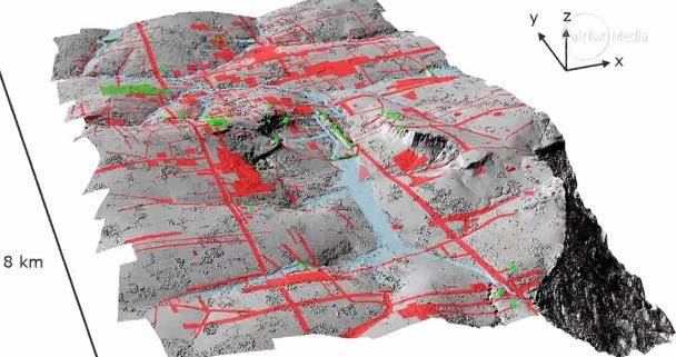
Wissenschaftler used laser technology to shed new light on the civilization behind the biggest religious complex in the world. During the time of investigations for several years, new findings reveal a much larger scale than was previously thought of in the urban expanse and temple complexes of the Khmer Empire.
Using high-tech lasers to scan the Cambodian jungle, Damian Evans and colleagues say they found traces of extensive networks surrounding the monumental stone temple complex at Angkor Wat. Evans said their findings could further our understanding of Khmer culture and throw into question traditional assumptions about the 15th-century decline of the empire.
The airborne Lidar system revealed a long-forgotten urban landscape in the jungle of Cambodia. The new research now reveals the sheer size of the ancient cities
Evans said a laser technology known as lidar was used to create precise maps of ancient networks that left only vague traces – invisible to the naked eye – in the landscape surrounding the temples.
‘You could be standing in the middle of the forest looking at what appear to be some random lumps and bumps,’ Evans said.
But they might actually be evidence of old excavated ponds or built-up roadways,’ he explained. ‘All of these things left traces on the surface of the landscape that wouldn’t make sense to you without a more detailed picture. To obtain such details, Evans said his colleagues spent 90 hours in a helicopter directing laser scans into the jungle surrounding Angkor Wat.
He said that the resulting images are so intricate ‘you can see objects lying next to a tiny anthill.’ The research was published Monday in the Journal of Archaeological Science. It was the result of a joint project including the French Institute of Asian Studies in Paris, the Cambodian national authority responsible for protecting Angkor Wat and the ministry of culture and fine arts.
New images from the survey show ancient cities near Angkor Wat were much bigger than previously thought. Above, a shaded relief map of the terrain around the central monuments of Sambor Prei Kuk
Angkor Wat, a UNESCO World Heritage site, is considered one of the ancient wonders of the world. It was constructed from the early to mid-1100s by King Suryavarman II at the height of the Khmer Empire’s political and military power and was among the largest pre-industrial cities in the world
For years, experts have assumed that the ancient Khmer civilization collapsed in the 15th century when invading Thai armies sacked Angkor Wat, forcing populations to relocate to southern Cambodia. But Evans said their laser maps showed no evidence of relocated, dense cities in the south and that it wasn’t clear there was any such mass migration.
Chanratana Chen, a Cambodian academic at the University of Sorbonne in Paris, said the new findings had changed his own perception of the Angkor Wat temple complex, which the Cambodian people commonly refer to as ‘the small city.’ Chen was not involved in the new research.
‘The new results (show) us that Cambodia was a much more advanced civilization than we thought, especially about the management plan of the city and irrigation system to improve agriculture in the area,’ Chen wrote in an email.
Among the most noteworthy discoveries, Evans and colleagues had found were proof of medieval sandstone quarries and traces of a royal road between various temple complexes, he said.
Evans doubted tourists would soon be flocking to see the unremarkable ‘mounds in the ground’ that the lasers had decoded at Angkor Wat. But said he and colleagues have now pinpointed sites that might be fruitful for further excavation.
He said it was likely there could be similar such discoveries elsewhere in Southeast Asia, possibly in Burma and even the Americas, where archeologists might unearth more secrets about the remains left behind by the 6th-century Mayan Empire.
Angkor Wat, a UNESCO World Heritage site, is considered one of the ancient wonders of the world. It was constructed from the early to mid-1100s by King Suryavarman II at the height of the Khmer Empire’s political and military power and was among the largest pre-industrial cities in the world.
The new findings build on scans that confirmed the existence of Mahendraparvata, an ancient temple city near Angkor Wat. However, until now, the sheer scale of the settlements was unknown.
The new findings build on scans that were made in 2012 (pictured) that confirmed the existence of Mahendraparvata, an ancient temple city near Angkor Wat. However, until now, the sheer scale of the settlements has remained unknown
Mr. Evans said: ‘What we had was basically a scatter of disconnected points on the map denoting temple sites. Now it’s like having a detailed street map of the entire city.’
Further maps will be published in the coming months.
Long Kosal, a spokesman for the Apsara Authority, the government body that manages the Angkor complex, said the lidar had uncovered ‘a lot of information from the past.’
He said: ‘It shows the size and information about people living at those sites in the past,’ but added that further research was now needed to capitalize on the finds.
While the Khmer Empire was initially Hindu it increasingly adopted Buddhism and both religions can be seen on display at the complex. Angkor is visited by hundreds of thousands of visitors a year and remains Cambodia’s top tourist attraction.
Scottish Farmer Discovers 5,000-Year-Old Lost City
Scotland is full of vivid, complex history, as is the case for other European compatriots. And no, it’s not all the violent headlines that Braveheart sees — though there is a great deal of war in the country’s rearview mirror.
Nonetheless, not so long ago, a farmer discovered something amazing about ancient Scotland buried in the sand dunes of one of the northernmost islands of the country The kicker? He found this amazing discovery behind something unbelievably ordinary…
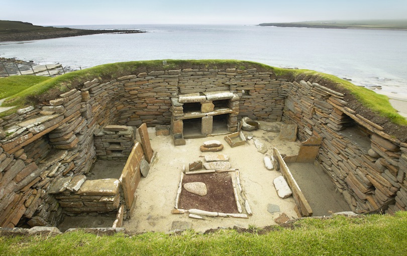
Around 1850 a Scottish farmer passed through the sand dunes of the western shore of the island of Orkney. There he pushed a rock aside and discovered something that had been hidden for thousands of years.
At first, he saw what looked like a simple hole, but when he peered inside, he couldn’t believe his eyes: it was a passageway that appeared to be a part of an entire labyrinth of rooms and corridors. An entire ancient city was hidden behind an ordinary slab of stone that whole time!
The settlement, it turned out, was the remains of Skara Brae, a neolithic city. Researchers believed that the ancient settlement might’ve been over 5,000 years old, making it more ancient than even the Egyptian pyramids.
Luckily, because the city had been covered by the sand dunes, it remained preserved for centuries until the farmer found it, untouched by other humans and hidden from the wear and tear of the passage of time.
Researchers believed that this was one of the oldest permanent settlements in Great Britain.
Each house had been sunk into middens, mounds of waste used to stabilize the structure and insulate those insides from Scotland’s brutal climate.
Though only eight houses now remain, it is believed the settlement was once much larger.
Researchers estimated this ancient lost city could have been home to between 50 and 100 people.
All of the houses were connected using a tunnel system, but those tunnels could be closed off and separated with large, sliding stone doors.
Early citizens would then be able to travel throughout the city, but close off their homes for privacy when they needed to.
Each hut contained multiple bedding areas; in most of the huts, researchers discovered, one of the bedding areas was typically larger than the others. These rooms were presumably reserved for the heads of the house—kind of like ancient master bedrooms.
The houses also contained a waterproof storage bin. Researchers believed this could’ve been an indication that these early people stored fresh fish in the huts. If that was the case, fish was likely their main source of food.
There are still questions to be answered about this hidden city and its people. Nevertheless, there is so much we can learn from ancient cities like this.
For many years, archaeologists thought that every important Egyptian discovery was already found. But that all changed recently.
According to a new study based on satellite imaging to map the ancient city, archaeologists have found the monumental building hidden under the sands of Petra.
A facade at Petra, where a new monumental structure has been found at the city built by Nabateans more than 2,000 years ago.
A massive 184-footed platform was revealed by satellite surveys of the city, with an interior platform that was paved with flagstones, lined with columns on one side and with a gigantic staircase descending to the east. A smaller structure, 28ft by 28ft, topped the interior platform and opened to the staircase. Pottery found near the structure suggests the structure could be more than 2,150 years old.
“This monumental platform has no parallels at Petra or in its hinterlands at present,” the researchers wrote, noting that the structure, strangely, is near the city center but “hidden” and hard to reach.
Zoomed-in UAV image of platform
“To my knowledge, we don’t have anything quite like this at Petra,” said Christopher Tuttle, an archaeologist who has worked at Petra for about 15 years and a co-author of the paper.
“I knew something was there and other archaeologists – who have worked in Petra for the last, God knows, 100 years at least – I know at least one other had noticed something there,” he said. But the structure’s sides resembled terrace walls common to the city, he noted: “I don’t think anybody paid much attention to them.”
Tuttle collaborated on the research with Sarah Parcak, a self-described “space archaeologist” from the University of Alabama at Birmingham, who used satellites to survey the site.
Parcak said that she begins surveys “quite skeptical” of what they might find – they are working on sites in northern Africa, North America, Europe and elsewhere – and that she was surprised to find the monument “turned out to be something significant”.
“Petra is a massive site, and we chose the name for our article [‘Hiding in plain sight’] precisely because, even though this is less than a kilometer south of the main city, previous surveys had missed it,” she said.
Tuttle and a team took subsequent trips to measure and examine the site from the ground. There they found scattered pottery, the oldest of which suggests the site could date back to the time of Petra’s founding. “We’re always very cautious about this,” Tuttle said, “but the oldest pottery can be dated back relatively securely to about 150BC.”
Petra was built by the Nabateans in what is now southern Jordan, while the civilization was amassing great wealth trading with its Greek and Persian contemporaries around 150BC. The city was eventually subsumed by the Roman, Byzantine, and Ottoman empires, but its ruins remain famous for the work of its founders, who carved spectacular facades into cliffs and canyons. It was abandoned around the seventh century and rediscovered by Swiss explorer Johann Burckhardt in 1812.
Along with the oldest Nabatean pottery, they found fragments that had been imported from the Hellenistic cultures who traded with Petra, as well as pottery of the eras when the Roman and the Byzantine empires took the city under their guard.
Overview of the monumental platform, looking south-east. Jabal an-Nmayr is indicated by the left-facing arrow and the slope of ‘South Ridge’ with agricultural terracing by the down-facing arrow.
In the mountains, valleys and canyons surrounding Petra, Tuttle said, “there’s tons of small cultic shrines and platforms and these things, but nothing on this scale”. He said these sites, including a large, open plateau known as the Monastery and probably “used for various cultic displays or political activities”, are the closest parallel to the newly discovered edifice. “To be honest, we don’t know a whole lot about it.”
Those sites suggest that the structure was used for “some kind of massive display function”, he said. Unlike those other sites, however, the giant staircase does not face the city center of Petra, which Tuttle called a “fascinating” peculiarity.
“We don’t understand what the purpose [of visible shrines], because the Nabateans didn’t leave any written documents to tell us,” he said, adding: “But I find it interesting that such a monumental feature doesn’t have a visible relationship to the city.”
Nabatean shrines around Petra offer mixed clues about the ancient people’s practices. Like other Semitic cultures of the day, the Nabateans used an indirect, “aniconic” style to indirectly represent their divinities: carved blocks, stelae and niches. Sometimes there will be “an empty niche, just a carving in the wall, which the empty space itself can be representative or they would’ve had portable images”, Tuttle said.
Previous surveys of the site had missed the structure.
But because they were in near-constant trade with other cultures of the Mediterranean, the Nabateans also adopted figural representations. “Nabatean gods depicted as parallels to Zeus or Hermes or Aphrodite, and those kinds of things,” he said.
The researchers published their work in the Bulletin of the American Schools of Oriental Research. They said that while they have no plans at this time to excavate the site, they hope they will have the chance to work there in the future.
Parcak said that she expects “some pretty amazing discoveries over the next year” using satellites and sophisticated new techniques in south-east Asia “and other densely forested/rainforest areas”. A surveying technology called Lidar, for instance, has uncovered sites in remote forests in Central America.
“This technology is not about what you find – but how you can think about things like settlement scale and ancient human-environment interactions more broadly,” she added. “What happens when you can truly map the near-surface buried features for an entire site? I’m excited, but we need to think about the implications of having all this technology at our fingertips so we can use it responsibly.”
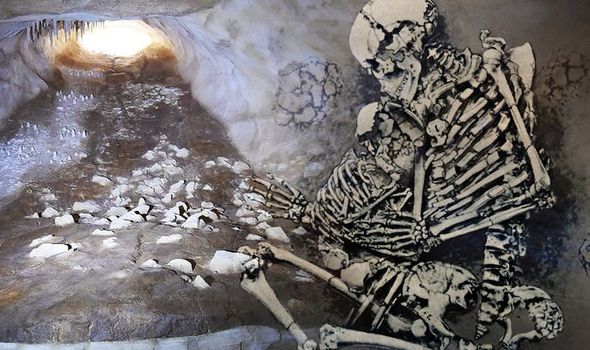
Archaeology breakthrough: Scientists discover chilling ‘nest’ of ancient humans in a cave
The discovery was made in a cave in France, which contained the remains of prehistoric hunter-gatherers who died some 30,000 years ago.
First discovered 20 years ago, the Grotte de Cussac cave is located in the southwest of the country. Frequented by members of the Gravettian culture of the European Upper Paleolithic, the finding shed fresh light on the burial rituals of Paleolithic humans.
The group left evidence scattered across the continent of Europe, appearing around 33,000 years ago. Particularly notable for its prolific cave art “Venus” figurines portraying voluptuous female figures and elaborate burial rituals, the culture has become famous among archaeologists.
France’s Lascaux cave and a crouched ancient skeleton found in Britain.
Researchers studied the cave and published their study in the journal Proceedings of the National Academy of Sciences. Here, an international team analyzed the caves remains using photographs and 3D rendering.
They concluded that the site provided a “unique” setting for the dead in the Paleolithic. Previous papers had reported the presence of human remains inside the cave.
However, the newest study is the first to provide a detailed description of all of them and a comprehensive analysis of the mortuary behaviours that led to the particular distribution of the bones. Contact with the cave’s surfaces is prohibited, forcing researchers to use indirect examination techniques.
The Carnac Neolithic standing stones in western France erected by pre-Celtic people
The researchers reported that the cave contained two areas of human remains. The first included the skeleton of a young adult male in a shallow depression that was once a bear nest, as well as the fragmentary remains of at least two other individuals spread across two other former bear nests.
Deeper in the cave, the second area, containing the remains of at least three individuals—two adults and an adolescent—in hollows along a wall, which appeared to be sorted largely by lower and upper anatomy.
Some of the bones and underlying sediments featured a red pigment that the researchers have linked to the remains. Many of the burials were similar to traits discovered in other Gravettian sites. But the authors of the paper say a handful of characteristics appear unique to this ancient culture.
For example, the researchers said the remains were found much further inside the cave than is typical and are associated with abundant rock art— an unusual feature for Gravettian burial sites — with the cave containing more than 800 engravings.
“These human remains are located deep in the cave, which is a unique finding for this period—all previously known Gravettian burials are located in open-air sites, rock shelters, or cave entrances,” Sacha Kacki, with the French National Center for Scientific Research, told Newsweek.
He added: “The Grotte de Cussac is not only a burial place but also a decorated cave. It is quite rare that Gravettian human remains are found close to (cave) art, and the Grotte de Cussac is the first discovered cave where the mortuary rites and the art are very likely contemporaneous.”
According to the authors, the findings shed new light on the burial practices of Gravettian hunter-gatherers, providing evidence of significant social complexity during the Upper Paleolithic (roughly 50,000 to 12,000 years ago.)
Mr. Kacki said: “Most of the human remains in Cussac are disarticulated due to human manipulations of bones or body parts after or during decomposition.
“Although post-mortem manipulations of human remains have been previously documented for other Gravettian sites, some types of manipulations at Cussac are unknown elsewhere, including the removal of crania and the deliberate commingling of the remains of several individuals.
“These observations indicate diverse and complex mortuary behaviors during the Gravettian, which provides a window onto the social complexity of human groups from the Upper Paleolithic.”
Massive Kingdom of Judah government complex uncovered near US Embassy in Jerusalem
Researchers in Israel have discovered a stunning ancient site near the U.S. Embassy in Jerusalem. The discovery was made in Arnona, the affluent neighborhood in southern Jerusalem where the embassy is located.
The Israeli Antiquities Authority has sent a message to Israel’s times saying that archeologists have uncovered an “extraordinarily large structure” with concentrated walls. Some 120 jar handles were also found bearing seal impressions with ancient Hebrew script.
A seal or bulla was used to authenticate documents or items in ancient times. According to the Israel Antiquities Authority, many of the handles have the inscription “LMLK,” (to the king), along with the name of an ancient city.
Other inscriptions have the names of senior officials or wealthy people from the First Temple period between 960 BCE and 586 BCE.
The site is believed to be a storage facility from the time of the ancient Judean kings Hezekiah and Menashe.
The site is believed to be a storage facility from the time of the ancient Judean kings Hezekiah and Menashe.
“This is one of the most significant discoveries from the period of the Kings in Jerusalem made in recent years,” said Neria Sapir and Nathan Ben-Ari, directors of the excavations on behalf of the Israel Antiquities Authority, in the statement. The site was used to store food supplies, they explained.
Small statuettes made from clay were also discovered at the site. “Some of the figurines are designed in the form of women, horse riders, or as an animal,” said Sapir and Ben-Ari, in the statement. “These figurines are usually interpreted as objects used in pagan worship and idolatry – a phenomenon, which according to the Bible, was prevalent in the Kingdom of Judah.”
“It seems that shortly after the site was abandoned, with the destruction of the Kingdom of Judah in 586 BCE and the Babylonian exile, the site was resettled and administrative activity resumed,” they added.
“During this time governmental activity at the site was connected to the Judean province upon the Return to Zion in 538 BCE under the auspices of the Achaemenid Persian Empire, which then ruled over the entire ancient Near East and Central Asia.”
Two-winged royal ancient Hebrew ‘LMLK’ seal impression — ‘Belonging to the King’ — found at the 2,700-year-old administrative complex in Jerusalem’s Arnona neighborhood.
The U.S. embassy in Arnona opened in May 2018 to coincide with the 70th anniversary of Israel’s independence.
Israel continues to reveal new aspects of its rich history. Hidden underground chambers dating back 2,000 years, for example, were recently discovered near the Western Wall in Jerusalem.
Clay figurines of women and animals found at the Arnona, Jerusalem excavation site.
Earlier this year, an international team of archaeologists uncovered an ancient Biblical era temple in what is now National Park Tel Lachish.
In another project, an Iron Age temple complex discovered near Jerusalem is shedding new light on an ancient Biblical city.
Last year, the room in Jerusalem venerated as the site of Jesus’ Last Supper was revealed in stunning detail thanks to remarkable 3D laser scanning technology.
A Christian holy site, the Cenacle (from the Latin for ‘dining room’), is located on the upper floor of the King David’s Tomb complex on Jerusalem’s Mount Zion.
Archaeology breakthrough: ‘Incredible’ discovery of the oldest remains of English royals
The remains of the English royalty of 1,000 years ago were discovered by the archeologists-the oldest find of the kind and a new light on the royal family history.
One of the most significant archeological findings in the last few years is that the queen Eadgyth who died aged 36 in 946AD, Researchers had believed the remains belonged to Eadgyth (Edith in modern English), the great-granddaughter of Alfred the Great, but could not prove it.
However, thanks to the use of hi-tech radioactive analysis of the remains, researchers were able to confirm that the bones belonged to someone who grew up in Wessex before moving to Germany.
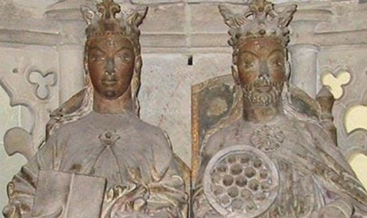
The statue in Magdeburg Cathedral that is often assumed to represent Queen Eadgyth
Leading the project, Professor Harald Meller said: “Medieval bones were moved frequently and often mixed up, so it required some exceptional science to prove that they are indeed those of Eadgyth.
“It is incredible that we have been able to do this using the most recent analytical techniques.”
Her remains were initially thought to have been lost when they were moved in 1510.
Many thought a monument built in Magdeburg Cathedral in eastern Germany, was a cenotaph in her honour.
The cenotaph is located at the German cathedral
And when the tomb was investigated as part of a wider research project, a lead coffin was found inside bearing her name and inside that the nearly complete skeleton of a woman aged between 30 and 40.
The University of Bristol then carried out tests on the bones in 2008 to prove beyond doubt they are those of England’s oldest regal ancestor.
The crucial scientific evidence came from the teeth preserved in the upper jaw. Eadgyth was the granddaughter of Alfred the Great and the half-sister of Athelstan, the first acknowledged King of England.
She was sent to marry Otto, the king of Saxony in AD 929, and bore him at least two children, before her death at around the age of 36. She lived most of her married life at Magdeburg, where the cenotaph is located.
Dr. Alistair Pike, Senior Lecturer in the Department of Archaeology and Anthropology at Bristol University, explained: “Strontium isotopes on tiny samples of tooth enamel have been measured.
“By microsampling, using a laser, we can reconstruct the sequence of a person’s whereabouts, month by month up to the age of 14.”
Mark Horton, Professor in Archaeology at Bristol University, added that it was “incredibly exciting” to confirm that the bones were the princess’s and to find out more about her life.
Mr. Horton continued: “This period was when England was really formed. “We don’t know much about these dark age queens and princesses.
“This has created a connection with one of them.
“Eadgyth seems to have spent the first eight years of her life in southern England, but changed her domicile frequently, matching quite variable strontium ratios in her teeth.
“Only from the age of nine, the isotope values remain constant.
“Eadgyth must have moved around the kingdom following her father, King Edward the Elder during his reign.
“When her mother was divorced in 919 – Eadgyth was between nine and ten at that point – both were banished to a monastery, maybe Winchester or Wilton in Salisbury.”