Archaeologists discover 4,800-year-old fossil of a mother cradling a baby
The ancient remains of a young mother and a child locked in a 4,800-year-old embrace were discovered by archeologists.
Of 48 sets of remains discovered from tombs in Taiwan, including five children’s fossils, this makes a remarkable discovery.
The scientists were shocked to find the maternal moment, which they claim are the first evidence of human activity in central Taiwan.
Archaeologists have uncovered the ancient remains of a young mother and an infant child locked in a 4,800-year-old embrace. The remarkable find was among 48 sets of remains unearthed from graves in Taiwan, including the fossils of five children
Preserved for nearly 5,000 years, the skeleton found in the Taichung area shows a young mother gazing down at the baby cradled in her arms.
Researchers turned to carbon dating to determine the ages of the fossils, which they traced back to the Neolithic Age, a period within the Stone Age.
Excavation began and took a year for archaeologists to complete. But of all the remains found in the ancient graves, one pair set stood out from the rest.
‘When it was unearthed, all of the archaeologists and staff members were shocked.
‘Why? Because the mother was looking down at the baby in her hands,’ said Chu Whei-lee, a curator in the Anthropology Department at Taiwan’s National Museum of Natural Science.
According to the researchers’ measurements, the mother was just 160 cm tall, or 5 foot 2 inches. The infant in her arms is 50 cm tall – just over a foot-and-a-half.
This breathtaking discovery came as a surprise to the researchers on sight, but it isn’t the first of its kind. In the past, archaeologists have dug up remains of similar moments that have been preserved for thousands of years.
Notably, Chinese archaeologists unearthed the interlocked skeletons of a mother and child last year from an Early Bronze Age archaeological site branded the ‘Pompeii of the East’, the People’s Daily Online reported.
The mother is thought to have been trying to protect her child during a powerful earthquake that hit Qinghai province, central China, in about 2,000 BC.
Experts speculated that the site was hit by an earthquake and flooding of the Yellow River.
Photographs of the skeletal remains show the mother looking up above as she kneels on the floor, with her arms around her young child. Archaeologists say they believe her child was a boy.
Researchers turned to carbon dating to determine the ages of the fossils, which they traced back to the Neolithic Age, a period within the Stone Age. Excavation began in May 2014 and took a year for archaeologists to complete
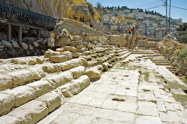
In Old Jerusalem workers have stumbled upon the ruins of the Siloam Pool, wherein John’s Gospel, Jesus cures a man who is blind from birth — the new find is praised as a discovery that helps to demonstrate the Bible’s historical authenticity.
In 2004, the stepped remains of the ancient Siloam Pool, long thought to be located elsewhere, were uncovered near the City of David. According to the Gospel of John, it was at this sacred Christian site that Jesus healed the blind man.
In the Los Angeles Times, James H. Charlesworth, a New Testament scholar of the Princeton Theological Seminary, had a quote: “Scholars have said that there wasn’t a Pool of Siloam and that John was using a religious conceit” to illustrate a point…”Now we have found the Pool of Siloam … exactly where John said it was.”
A gospel that was thought to be “pure theology is now shown to be grounded in history,” he added.
Sewer workers discovered the pool some 200 yards from another Pool of Siloam, this one constructed somewhere between 400 and 460 AD by the Empress Eudocia of Byzantium, who, experts say, commissioned the rebuilding of several biblical sites.
Archeologists say that the pool which appears in John’s Gospel was built around the 1st century BC and destroyed by the Roman Emperor Titus in 70 AD.
The sewer line repair which led to the discovery was being overseen by Eli Shukron of the Israel Antiquities Authority who, according to the LA Times report, was “100% sure it was the Siloam Pool,” when his group saw two steps unearthed by the workers.
The account of the pool in the Gospel of John shows Jesus encountering a man there who had been blind since birth. Jesus’ disciples thought that the man was blind because of some sin of his own or his parents.
Jesus then responds that the man is blind so that God’s work might be revealed in him, spits in the dust to make mud and rubs it in the man’s eyes telling him to wash himself in the Pool of Siloam.
The return of the man’s sight makes this story one of the most often recalled in the whole of the Gospels. Now, theologians and biblical scholars are excited that the significance of this miracle can be appreciated in a whole new light.
Artist’s rendering of the Siloam Pool, the Biblical Christian site where Jesus healed the blind man
800-year-old vases containing frozen clotted cream and yellow butter found from glacial
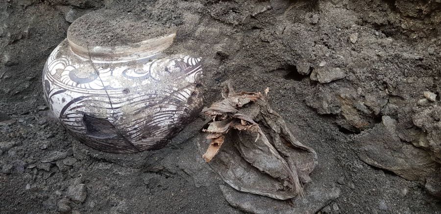
An anomaly of three clotted creams and one vase of yellow butter preserved in glacier about 700 to 800 years ago is discovered in the “Umard Mongol” joint investigation team of the National Museum of Mongolia, the University of Pittsburgh and the United States American Center for Mongolian Studies.
The excavation is considered to possibly be a new discovery for the international archeology scene alongside being a discovery related to nobles of the Mongolian Empire.
During the research team’s work on the protection of looted tombs relating to the Mongolian Empire and collecting artifacts that they found in 2018 and 2019 at the site named Khorig in Ulaan-Uul soum of Khuvsgul aimag.
They came across a large number of artifacts that are highly significant in research, which included the aforementioned vases with frozen clotted cream and yellow butter that were even more of a rare case.
Highly significant artifacts relating to the history of the Mongolian Empire such as items made of gold, silver, iron, silk, bones, hide and cork, as well as human and livestock bones, have also been found.
Specifically, gold relics with depictions of a golden sun, silver moon and deity, earrings and a golden accessory of a belt were unveiled with the several hundred artifacts that included various items such as a leather sack filled with trinkets in silk wrappings.
A part of a silk deel with a swastika pattern, dragons and other mythical creatures with golden thread, a part of a leather boot, bow and arrowhead, arrow case, porcelain, and clay vases, bone brush, and equestrian equipment.
The research team is being led by the Head of the Research Center at the National Museum, Dr. J.Bayarsaikhan, and Dr. Julia Clark.
These cultural findings are expected to serve as proof of the triumphant history of the Mongolian Empire and have an important role in developing patriotic views and respect for national heritage for the future generations of Mongolia.
2,000-Year-Old Monolith Engravings Recorded in Peru
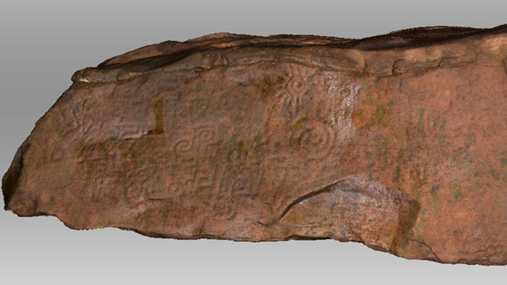
A 2000-year-old jungle monolith decorated with circles, spirals and feline fangs has been 3D scanned in its remote Peruvian location.
Peru is a land of history, myths, and home of some of the most amazing ancient civilizations to ever live on Earth. Inhabited by various ancient cultures such as the Inca or the Tiwanaku and Nazca people, Peru is also home to some of the oldest pyramids ever erected in South America.
The ancient city-state of Caral, for example, was home to people who created some of the most impressive pyramids ever constructed in this part of the world.
But Peru hides many other secrets.
One such secret is a massive one-ton monolith believed to be around 2,000 years old. Not many people know about it, and only a few explorers have seen and documented its existence. Decorated with spirals, circular patterns, and fangs of a deity, the massive rock lies hidden in the north of the Peruvian jungle.
Despite the fact that locals knew of its existence, never has the massive monolith actually been submitted to analysis. Now researchers decided to investigate the massive rock, to see what they could learn. Scientists performed a three-dimensional scan that revealed several engravings adorning its surface.
The images and patterns are so abstract and ornate that they are difficult to describe in words. However, the researchers say that two fangs carved into the rock represent a deity known in archeology as “winged feline figure.”
A 3D scan of the monolith revealed striking symbols.
Reaching the location of the monolith is no easy task. To get there, the researchers began the trip from the town of Leymebaba. Their journey took them on a massive adventure: “we hiked, ran, rode horses through jungles from 6,000 feet [1,800 meters] up to 13,000 feet [4,000 m] to this really remote village where literally nobody goes,” explained Jason Kleinhenz, an application engineer at Exact Metrology, who scanned the monolith in an interview to Live Science.
The goal of the mission was to thoroughly document the monolith and its symbols, using an Artec 3D scanner, especially because the engravings on its surface are in danger of being lost forever due to wind and rain erosion.
Since the stone had remained unstudied and exposed to torrential rains, researchers feared that once they reached the monoliths location, the symbols had disappeared.
However, this was not the case.
Thankfully, when researchers finally arrived at the location where the massive monolith remained hidden, they found a plethora of symbols on its surface. sing their 3-D scanner, the researchers were able to find and document symbols that remained invisible to the naked eye, like the fangs of a winged feline figure. It is precisely this feline figure that helped experts date the massive rock and its symbols.
According to experts, the winged feline engraving indicates that the symbols that carved on the surface of the monolith were created during what archaeologists call the “formative period,” which occurred between 200 BC. and 200 A.D. Researchers note that despite the fact that there were no writings in Peru at that time, studies of other related archeological sites showed that this figure was popular in the area.
Fernandez-Davila stressed that the monolith was likely of great importance and may have been associated with other similar structures. “It’s iconic … only people of that period can carve it the way that it is,” Fernandez-Davila explained. The researchers further explained that the jungle valley where the monolith was placed was most likely “a very important and sacred place.”
What is extremely interesting is the fact that the monolith–which weighs around one ton, and is three meters long, 76 centimeters high and 1.5 meters wide–is made of sedimentary rock that is not found locally, which means that whoever carved it most likely hauled it into the jungle valley from somewhere else.
Dragging the monolith to its present location, though the dense jungle would have been an extremely difficult task, and likely required many people.
“That itself was a tremendous effort, a communal effort definitely,” Fernandez-Davila explained. Evidence that the area where the monolith was located was of great importance is the fact that during the Inca built two baths in close proximity of the monolith, around the 15th century AD.
To understand more about the area, the culture that may have carved the monolith, and the rock itself, researchers plan future expeditions that will hopefully reveal more clues and solve yet another ancient mystery.
Oddly the symbols engraved on top of the Peruvian monolith bear a certain resemblance to another monolith located in Brazil. The Pedra do Inga is a 6,000-Year-Old ancient monolith located in the interior of the Brazilian state of Paraíba. Most of the symbols etched on its surface are thought to depict animals, fruits, humans, constellations, but also a plethora of yet unrecognizable symbols and images. Its most striking symbols are believed to depict stars, the Milky Way as well as the constellation of Orion.
The Pedra do Inga in Brazil, is covered in strange symbols that experts believe are depictions of stars, galaxies, and even constellations.
The Pedra do Inga is much more massive than its Peruvian counterpart: it covers an area of approximately 250 square meters. Although it is difficult to ascertain the age of the rock, experts have proposed that rock formation and its mysterious symbol could be up to six thousand years old.
To date, experts have identified more than 400 engravings on the stone’s surface. Some of the spirals and circles depicted on the Peruvian Monolith bear a strange resemblance to the symbols etched on the Pedra do Inga in Brazil. Is it possible that both monoliths have astronomical importance? If the symbols etched on the Pedra do Inga depict constellations and galaxies, could the symbols on the Peruvian monolith convey the same meaning?
Are these two stones meant to convey the same message left behind by our ancestors? Did the same civilization create them? Does the Peruvian monolith also depict constellations and stars? Further studies will tell.
How a-boat this! Huge 700-year-old shipwreck found at bottom of river Vistula
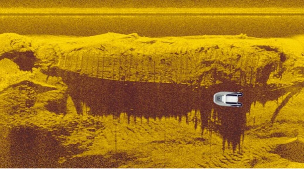
The underwater archaeologists in Vistula River north of Warsaw, Poland, discovered a centuries-old shipwreck described as “huge and rare.”
This historical boat was the discovery by a group of submarine explorers searching in the Vistula River north of Warsaw in Poland for a whopping 37 meters long (121 foot) and 6 meters wide (20 foot) and the article in Science in Poland reveals that the boat used to carry up to “100 tons of goods.”
Funded by the Ministry of Culture and Scientific Heritage with support from the Warsaw Institute of Archaeology, and the “massive” newly discovered boat is thought to have been a transport vessel operating between the 14th and 18th centuries.
Dr. Artur Brzóska is an underwater archaeologist and head of the research project from the Association of Archaeologists Jutra, and he believes it probably “transported grain to Gdańsk.”
Poor visibility and strong water currents were among the negative environmental challenges that stopped the divers from recovering any artifacts from the sunken ship.
But Brzóska pointed out that wrecks such as these are “very rare” and until this discovery, only two wrecks were previously known in this part of the river: a 16th century and 19th-century ship.
This new boat is a so-called “berlinka,” which was an elongated, shallow, barge-type craft designed for canal transportation, and while an article like this makes it all sound so simple, finding the rare wreck took what amounted to a major scientific operation.
Sonar image of the centuries-old boat discovered in the Vistula River in Poland.
Before the researchers discovered the “huge” boat they mounted hi-tech sonar equipment around a motorboat and selected a series of test sites with a view to diving at any interesting findings on the scans.
The system was tested on the Vistula River near Warsaw`s Old Town and the project required sailing around 400 kilometers (250 miles) along parallel survey lines scanning a 13-kilometer-long (8 miles) stretch of the river, covering nearly 500 hectares in all.
The scientists first found the decomposing remains of a World War II bridge sunk near Łomianki Dolne, and the geometry of its steel structure informed Brzóska’s team that it had been built by “German sappers.”
They also found parts of another ship driven into the bottom of the river and a fragment from the vessel pulled to the surface led Brzóska to the conclusion that it too might have been a cargo boat, similar to the huge one they discovered.
Researchers about to dive at the site of the shipwreck on the Vistula River in Poland.
While the wrecks being discovered today are from the last 600 years, beneath them, deep in the silts of the riverbed, are the rotting remains of much more ancient vessels, as the Vistula basin was occupied in the 1st millennium BC by Iron Age Lusatian and Przeworsk cultures.
1st-century Roman authors called the region “Magna Germania” and in the 2nd century AD, Ptolemy described the Vistula River as the border between Germania and Sarmatia.
According to an article on Suwalszczyzna, the Vistula River used to be connected to the Dnieper River, and thence to the Black Sea via the Augustów Canal, one of the most ancient trade routes, the Amber Road, which connected Northern Europe with Asia, Greece, Egypt, and elsewhere.
Encyclopedia Britannica says that for hundreds of years the river was one of the main trade routes of ancient Poland and the Vistula estuary was settled by Slavs in the 7th and 8th centuries.
Moving through the canals of time, the magnificent if not ostentatious castles and fortresses that line the riverbanks all stand testimony to the wealth accumulated through the trade of salt, timber, and stone between the 10th and 13th centuries.
Shot of the Vistula River in Poland where the shipwreck was found.
In the 16th century most of the grain exported from Poland left from the city of Gdańsk, and is located at the end of the Vistula, with its Baltic seaport trade connections, it became the wealthiest, most highly developed and connected of the Polish cities. It was this thriving Polish city that Dr. Artur Brzóska believes the newly discovered massive barge transported grain too, but the team is awaiting further results before drawing this conclusion.
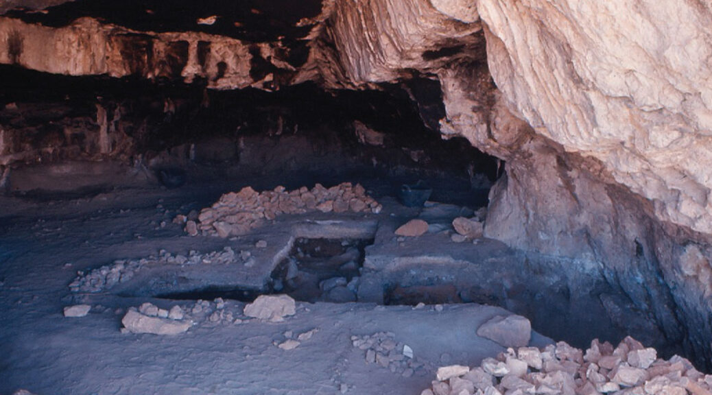
Anthropologists confirm the existence of specialized sheep-hunting camp in prehistoric Lebanon
A view of excavations in the Nachcharini Cave taken at end of the season in the summer of 1974
The presence of a hunting camp, currently situated in north-eastern Lebanon, over 10,000 years old, has been confirmed by anthropologists at the University of Toronto – one that straddles the period marking the transition from nomadic hunter-gatherer societies to agricultural settlements at the onset of the last stone age.
The study of decades-old, collected from the Nachcharini Cave high in anti-Lebanon mountains that form the modern-day border between Lebanon and Syria, shows the site as a short-term hunting camp that served as a temporary outpost to emerging and more substantial villages elsewhere in the region, and that sheep were the primary game.
The finding confirms the hypothesis of retired U of T archeologist Bruce Schroeder, who excavated the site on several occasions beginning in 1972, but who had to discontinue his work when the Lebanese Civil War began in 1975.
“The site represents the best evidence of a special-purpose camp – not a village or settlement – in the region,” said Stephen Rhodes, a Ph.D. candidate in the department of anthropology in the Faculty of Arts & Science and lead author of a study published this week in PLOS ONE.
“The cave was a contemporary of larger settlements further south in the Jordan Valley, and is the first site of its kind to show the predominance of sheep among the animals hunted by its temporary inhabitants.”
The view of looking out of the cave in northeastern Lebanon where U of T researchers confirmed the existence of a more than 10,000-year-old hunting camp
Radiocarbon dating of animal bones recovered from the site shows that it dates to an era known as the Pre-Pottery Neolithic A (PPNA), a period from about 10,000-8,000 BCE during which the cultivation of crops, the construction of mud-brick dwellings and other practices of domestication began to emerge. The stone tools found at the sites are mostly tiny arrowheads used for hunting.
The new dates place the main deposits at the cave securely in the PPNA.
“Previous dates established in the 1970s were problematic and far too recent for unknown reasons, possibly due to contamination or incorrect processing,” said Rhodes, who coauthored the study with Edward Banning and Michael Chazan, both professors in U of T’s department of anthropology.
“The results highlight the fact that people in the PPNA took advantage of a wide variety of habitats in a complex system of subsistence practices.”
It was already known that sheep hunting was practiced in this region throughout periods that preceded the PPNA, and the evidence found at Nachcharini Cave reinforces that understanding.
According to Rhodes, it consolidates our knowledge of the natural range of sheep, which pertains to a potential beginning of domestication in later years.
“We are not saying that hunters at Nachcharini were engaged in early stages of this domestication,” he said. “But the evidence of a local tradition makes this area a possible center of sheep domestication later on.”
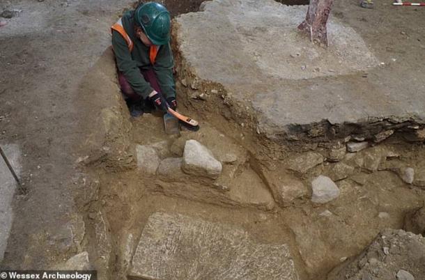
Anglo-Saxon Abbey where Lusty King Edgar was Crowned, Found!
The ruins of two stone buildings found during restoration work at Bath Abbey by Wessex Archeology specialist, it was discovered during renovation work at Bath Abbey, to the 8th – 10th century.
Bath Abbey Somerset, England.
The site at Bath Abbey
It is probably part of the Anglo-Saxon monastery where King Edgar was crowned as the first King of England in 973 AD.
In the excavation project Bath Abbey’s Footprint, the two foundations were uncovered underneath the street level, as part of Bath Abbey’s Footprint project.
The Wessex Archeology team revealed the apsidal (semi-circular) structures below an area where the cloisters of the 12th-century cathedral would have once stood and overlying earlier Romano-British deposits.
An internal plaster renders on the southern-most apse contained fragments of charcoal from which two samples were sent for radiocarbon dating at Queen’s University, Belfast.
The dates came back as AD 780-970 and AD 670-770, much to the delight of Wessex Archaeology Senior Project Officer Cai Mason, who said: “When you find something unusual, you have to think ‘what is the most mundane explanation for what we’ve found?’, and most of the time that will be the explanation, but sometimes that doesn’t work, which makes you wonder ‘have we found something genuinely unusual?’
“In a post-Roman context, the most likely place to find this type of structure is at the east end of an ecclesiastical building, such as a church or chapel, and given the fact that the excavated structures are surrounded by late Saxon burials, this is the most likely explanation for their use.
Excavations of the possible Anglo-Saxon abbey at Bath Abbey.
“This, together with the late Saxon stonework and burials found at the Abbey, provides increasingly strong evidence that we have indeed found part of Bath’s lost Anglo-Saxon monastery.”
Wessex Archaeology Project Manager Bruce Eaton added: “Given that the potential date of these structures spans some 200 years there are several possible contexts for their construction.
“One possibility would be the reign of King Offa of Mercia, who acquired the monastery in AD 781 and is credited by William of Malmesbury for building the famous Church of St Peter, probably utilizing the ready supply of worked stone from the near-by collapsing Roman baths complex.
“Extensive building work within this period is further attested to by Offa’s successor Ecgfrith having the infrastructure in place to hold court at the monastery in AD 796.
“This phase of energetic building activity does fit neatly with our earliest possible date for the plasterwork, but it is certainly not our only candidate.”
The Reverend Canon Guy Bridgewater at Bath Abbey, said: “This is a really exciting find. While we’ve always known there once was an Anglo-Saxon monastery on this site, no trace of the building remains above ground today, so it’s amazing that we now have an actual record of it and can get a real sense of it as it was.
“The excavations being carried out as part of our Footprint project are essential to make major improvements to the current Abbey church, and how we use it.
“A massive benefit has been working with Wessex Archaeology who are making important discoveries about Abbey’s 1,000-year heritage all the time.”
The Anglo-Saxon structures are among a series of exciting discoveries made by Wessex Archaeology during their excavations at Bath Abbey. In August 2018, the team uncovered a vibrantly coloured 14th century tiled floor in what would have been the nave of the medieval cathedral.
They have excavated a Mesolithic land surface below the Victorian plant room, Roman buildings which would have once stood in the heart of the town of Aquae Sulis, an Anglo-Saxon cemetery containing rare charcoal burials and the medieval cloister walk.
More recent finds have included the coffin-plate of controversial Georgian demographer Rev. Thomas Malthus and recovered painted fragments of the lost Jacobean plaster ceiling of the current Abbey church.
Waves Over Centuries Has Carved this Marble Cave into Stunning Shapes and Swirling Patterns
The Cuevas de Mármol is situated on a strong marble island on the edge of the General Correra Lake on the Patagonian Andes, an outlying glacial lake that stretches across the border between Chile and Argentina.
Dubbed as the most beautiful cave network in the world, Cuevas de Marmol (Marble Caves) is a 6,000-year-old sculpture hewn by the crashing waves of Lake General Carrera of Patagonia in Southern Chile.
Also called the Marble Cathedral, the intricate caverns are part of a peninsula made of solid marble surrounded by the glacial Lake General Carrera that spans the Chile-Argentina border.
The swirling pattern on the cave interiors is a reflection of the lake’s azure waters, which change depending on the water levels dictated by weather and season.
Visitors are enamored by the Marble Cave’s unique ability to constantly change its appearance.
In early spring, the shallow waters are turquoise and create a crystalline shimmer against the caves’ swirling walls. Come summer, the water levels increase and create a deep blue hue which gives the cave a unique unearthly shade.
The water levels are significantly affected by the freezing and melting of the surrounding glaciers. It’s also from these glaciers where the lake takes the fine silt sediments that rest on the lake bed.
To get to the caves, one must embark on a long and difficult journey starting from a flight to the Chilean capital of Santiago. Visitors must then travel 800 miles on major highways to the next big city Coyhaique, followed by a 200-mile drive on rough dirt roads towards the lake.
Located far from any road, the caves are accessible only by boat. Thirty-minute tours are operated by a local company, weather and water conditions permitting.
The best time of the year to visit the Marble Caves is roughly between September and February when the ice melts feeding the lake and the color of the water is particularly enchanting turquoise.
In terms of hours, the best time to take a boat tour is early morning to catch the right lighting for great pictures.
Finally, a boat is needed to access the caves. But though the journey is long and challenging, many agree the enchanting beauty of the caves is definitely worth the effort.