Farmer’s Field in Poland Contains 2,000-Year-Old Cemetery

Farmer’s Field in Poland Contains 2,000-Year-Old Cemetery

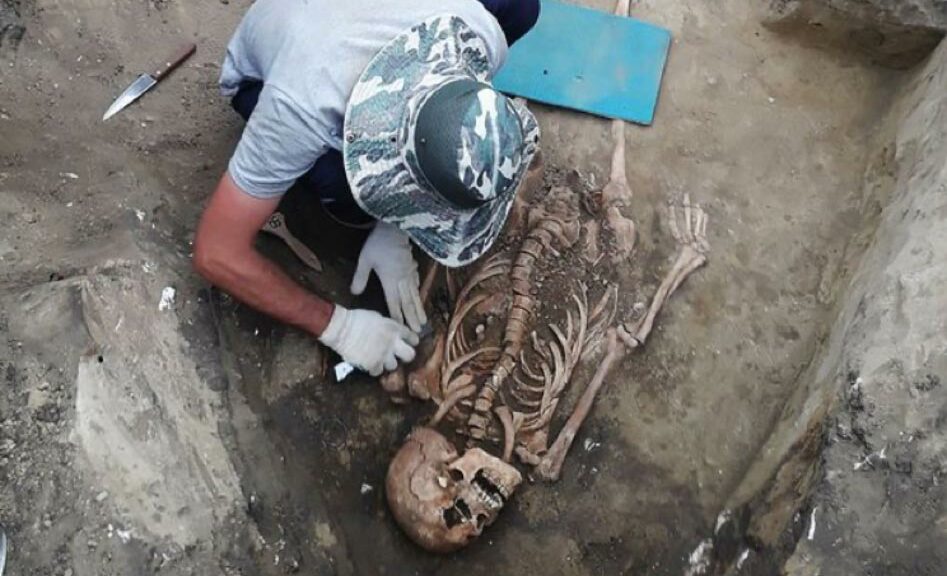
Warrior graves dating back 2,000 years have been found by archaeologists near Bejsce in the province Świętokrzyskie. The cremated remains were accompanied by weapons: iron swords and spear or javelin heads. According to the archaeologists, the newly discovered cemetery covers around 1 ha.

The grave was found after surface surveys were carried out in some arable fields in the spring this year by archeologists.

The archeological team decided to further excavate after finding a large number of burnt bones in their early search.

The burial ground was discovered under a farmer’s field in Poland.

Although many of the remains have been badly damaged, the team discovered 20 graves over an area of 200 square meters.

Jagiellonian University research project leader Jan Bulas said: “We don’t know precisely how many graves in the cemetery were since our research is still at the early stage. We are working on the cemetery.

Warrior’s grave at the time of discovery.

“The graves are destroyed and often spread over a large area of the field.”

He added: ”Heavily corroded and seemingly shapeless objects turned out to be fragments of swords or iron fibulas.” The team discovered in a total of four swords, and nine spearheads, as well as some mysterious square structures.

The structures have a square base and a triangular cross-section and are baffling archaeologists as to their use. Mr. Bulas hazarded a guess that they might have been used to demarcate space in cemeteries for individual families.

He explained: ”Similar structures, so-called grooved objects, are known from other cemeteries from this period in southern Poland, but their function is still unclear.

“In Bejce, they contained fragments of ceramic vessels as well as metal objects.”

Archaeologists counted nearly 200 metal artifacts and their fragments after this year`s research. There are also bone, stone and clay items.

The archaeologists believe that the dead warriors were members of the Przeworsk culture. Mr. Bulas thinks that they could have been representatives of the Lugii tribal union.

The Lugii was a large tribal confederation mentioned by Roman authors living in around 100 BC–300 AD.

Among the easternmost Celtic tribes in Germania, the Lugii lived in the area which today roughly forms the meeting point between eastern Slovakia, southern Poland and western Ukraine (an area which was later known as Galicia).

The Lugii may also have resided farther north, in Pomerania, prior to moving south. They played an important role on the middle part of the Amber Road from Sambia at the Baltic Sea to the Pannonia, Noricum and Raetia provinces of the Roman Empire.

The Lugii has been identified by many modern historians as the same people as the Vandals, with whom they must certainly have been strongly linked during Roman times.

Intriguingly, a tribe of the same name, usually spelled as Lugi, inhabited the southern part of Sutherland in Scotland.

Controversy exists as to whether particular tribes were Germanic or Celtic, and the Lugii is one of those tribes which may straddle both definitions because they were a tribal confederation rather than a single tribe.

The Lugi name appears to have been based on the name of the Celtic god, Lugus. He is more commonly known as the Irish Lugh or Lug (probably cognate to the Latin ‘lux’, meaning ‘light’).

In northern Iberia, a sub-tribe of the Astures carried the name Luggones, and nearby was the similarly named Louguei sub-tribe of the Gallaeci.

1,400-Year-Old Anglo-Saxon Burial Unearthed in Canterbury

1,400-Year-Old Anglo-Saxon Burial Unearthed in Canterbury

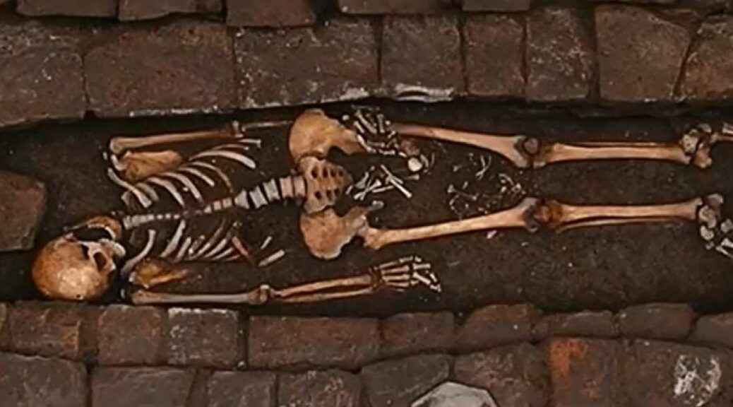
On a university campus in Canterbury, the extraordinary remains of a young Anglo-Saxon woman, buried with luxuriant jewels and a knife.

While Archeologists working at Christ Church University at the site of its new £65 million STEM building they Unearthed the burial, which is due to open in September next year.

The female, who had thought she was in her 20s, was found buried with a silver, garnet-inlaid, Kentish disc brooch.

She was also wearing a necklace of amber and glass beads, a belt fastened with a copper alloy buckle, a copper alloy bracelet and was equipped with an iron knife.

Experts say that together, the items found in the grave suggest the woman was buried between AD 580-600.

They believe she would have been a contemporary, and likely acquaintance, of the Kentish King Ethelbert and his Frankish Queen Bertha, whose modern statues can be seen nearby at Lady Wootton’s Green.

The bones have been studied by Dr. Ellie Williams, Lecturer in Archaeology at the University.

The stunning broach found with her

“The discovery of another ancient burial on our campus is extremely exciting,” she said.

“It demonstrates the richness of the archaeology that surrounds us, and contributes important new evidence to our understanding of life and death in Canterbury around 1,400 years ago.”

Dr. Andrew Richardson, outreach and archives manager at the Canterbury Archaeological Trust, which made the discovery, says the discovery is “particularly significant”.;

“It suggests that relatively high-status burial was taking place on the site in the years shortly before the establishment of the Abbey.

“One of the primary roles of the Abbey was as the burial place of Augustine and his companions, Archbishops and members of the Kentish royal dynasty.

Cremation urns were also discovered

“This find suggests that this may represent a continuance of existing practice at the site, rather than a completely new development and has implications for our interpretation of this World Heritage site.”

Scientific testing on similar finds has shown the garnets are likely to have come from Sri Lanka rather than a nearer source.

Such brooches, crafted in east Kent from exotic materials, were produced at the behest of the Kentish royal dynasty and distributed as gifts to those in their favor.

The woman’s bones will be retained for further scientific study, which it is hoped will provide insight into her life, death, and burial.

45,000-year-old Cave Lion Figurine Uncovered At Denisova Cave

45,000-year-old Cave Lion Figurine Uncovered At Denisova Cave

Three months ago a group of archeologists from the Novosibirsk Institute of Archeology and Ethnography performed a groundbreaking discovery in the Altai Mountains.

An upper paleolithic artist created between 40,000 and 45,000 years ago the precious little figure – of 42 mm long, 8 mm thick and 11 mm high – of a Cave Lion (Panthera Spelaea, Lat).

It was located in the 11th layer of the Denisova cave South Gallery. This is the oldest zoomorphic sculptural image ever found in Siberia and in Northern and Central Asia.

The Lowenmensch figurine or Lion-man of Hohlenenstein-Stadel found in 1939.

The exact age has not yet been verified, but Siberian archeologists have provided a cautious datation that implies that this could be the oldest animal figure in the world.

The head of the lion is missing the hind legs, groin back and belly are visible, decorated with a design of eighteen rows of notches. There are two extra rows with four notches on the lion’s right side.


Aged approximately 45,000 years, this might be the world’s oldest animal statuette.

‘The figurine depicts an animal with its tummy tucked in, its hind legs bent. It is either galloping, jumping or getting ready to jump. The animal is shown in a typical for big cats position for the moment when they are ready to catch a prey’, said Mikhail Shunkov, head of the Institute’s Stone Age Archeology Department.  

The mammoth ivory for the statuette was delivered from quite a distance away, Russian scientists say. It had to be carried for at least 100 kilometres from the northern footsteps of the Altai Mountains. 

Art objects made of mammoth ivory from the 24,000-year-old Mal’ta site in south-central Siberia.

After finishing the figurine, the cave artist used red ochre to paint it.  So far traces of it were found mostly around the stomach area – which even led to an idea that it could be symbolising a bleeding wound – but researcher Alexander Fedorchenko believes that most likely the whole animal was painted red. 

Remains of ocher were found only in the southern gallery of the Denisova cave.  In 2018 a ‘pencil’ and a marble stone with traces of ocher powder were discovered in the same area where later archaeologist unearthed the cave lion – making the trio the first set of such kind in the history of Siberian archaeology. 

It is still unclear if the figurine depicts a male or a female lion, as well as the purpose of the find. The archaeologists believe it is ‘too simplistic’ to assume this was a toy, but there is no proof that it could have been a cult item.

The artist’s identity is another question to be answered. The assumption is that it was a Denisovan, but as professor Shunkov added, ’45000 years ago was the time when Homo sapiens already wondered around Siberia, so it was quite likely that they could have influenced the Denisovans.’

Was this one of the first-known artistic collaboration then? 

The answer is yet to come, say archaeologists, but they are certain that by the style it was made the Denisovan Cave Lion doesn’t resemble anything previously found in the world. 

The closest in style are cave lions figurines from Vogerfelt Cave in south-west Germany, and from caves in south-west France. The Denisova Cave lies right at the border of the Altai region and the Altai Republic in the south of Western Siberia. 

The Denisovan Bracelet made of chloritolite and found in the Denisova Cave.

Locals call it Ayu Tash, which means Bear Rock.  Now world-famous, the cave first caught the attention of Soviet scientists in 1970s when they found first paleo-archaeological remains. 

It was inside the Denisova Cave in 2008 that Siberian archaeologists discovered a tiny finger bone fragment of ‘X woman’, a juvenile female believed to have lived around 41,000 years ago. 

The Denisova cave

The analysis showed she was genetically distinct from thick-browed Neanderthals and modern humans. The recent addition to the human family tree was christened Denisovan. 

Further research showed that the Denisovans were a sister group of Neanderthals. The two groups split from a common ancestor around 390,000 years ago. 

Like Neandertals, Denisovans lived until about 40,000 years ago.  The Denisova Cave is relatively small with a floor area of about 270m2.  It has three galleries – the cosy Central Chamber with high, arched ceiling and a hole that lets in natural light, the South Gallery and the East Gallery. 

The cave is nicely positioned above river Anuy, which must have given all three hominids – the Neanderthals, the Denisovans and the Homo Sapiens – some stunning sunset views over the past 120,000 years.  Now the site has a permanent research camp, a pride of Novosibirsk Institute of Archaeology and Ethnography. 

8,000-Year-Old Monument Uncovered in Turkey

The Anadolu Agency reports that a monument thought to be 8,000 years old has been discovered in northwestern Turkey’s Ugurlu-Zeytinlik mound by a team of researchers led by Burcin Erdogu of Trakya University.

According to the head of an excavation team, a monument that is supposed to be about 8,000 years old was discovered in northwest Turkey.

“We have found a structure that we think is dated about 6,000 B.C. during these year’s excavation work,”

Burcin Erdogu from Trakya University, archeologist and head of the excavation team, told Anadolu Agency on Thursday.

Excavations in the Ugurlu-Zeytinlik mound in the northwestern province of Canakkale’s Gokceada district had earlier unearthed a 7,000-year-old structure complex.

Erdogu said the new excavation will through lighter on the history of Gokceada, which dates back to 8,800 years.

“This structure is an important discovery both for the Aegean islands and western Anatolia,” she said. She added that the T-shaped monument is an obelisk – tall, four-sided tapering structure, ending in pyramidion.

It is made of two pieces, interconnected by seven-meter-long walls. It reminds standing stones in Gobeklitepe, an archeological site located in Turkey’s southeastern Sanliurfa province.

Erdogu said it was the general thought that public structures, such as temples, were disappearing through the near East.

“The monumental structures seem like part of an area where people gathered and held some activities and rituals,” she added.

How ‘secret Inca city’ was found hiding below Amazon jungle rising ‘lost treasure’ hopes

How ‘secret Inca city’ was found hiding below Amazon jungle rising ‘lost treasure’ hopes

Some scholars consider the Incas to be the most powerful in the Americas, occupying the Peruvian mountains until 1572, when the Spaniards captured the last fortress.

Proof of this advanced civilization is still visible today, with Machu Picchu, the most famous tourist destination, becoming the most popular. The least known settlement of Choquequirao is hidden, however, in the shadows of this fortification of the 15th century, which is located 2430 meters above sea level.

Reachable only from a two-day hike from Cusco, this city was one of the last bastions of resistance and spans more than 18,000 square meters into the deep undergrowth of the Amazon jungle. 

Only around 30 percent of Choquequirao has been excavated and Amazon Prime’s “Mysterious World of the Inca” revealed why this location was key. 

The narrator said in 2009: “All across the former empire of the Incas we find numerous strange and mysterious places called Huaca, these were a kind of idol, which according to the Indians, had supernatural powers. 

“In addition to artificially created shrines, a Huaca could be practically anything, such as strangely shaped stones, mountains or lakes. 

How ‘secret Inca city’ was found hiding below Amazon jungle rising ‘lost treasure’ hopes
The lost city of the Inca
The place was chosen as a strategic location

“Many remained hidden from the Spanish like Choquequirao, another gem of Inca architecture escaped destruction at the hands of the conquerors. “This is thanks to its inaccessibility, as it hides in the shadows of the famous Machu Picchu. 

“It is likely that its significance was more practical than spiritual, on nearby slopes they grew cocoa, an ideal plant for the local climate.”  The series went on to reveal how this settlement was first uncovered.  The narrator added: “After the death of the last Inca, at the end of the 16th century, Choquequirao fell into oblivion.

The city hides many secrets

“The first Europeans arrived in this place only in the mid 19th century and the city, which means Cradle of Gold, was rediscovered by Hiram Bingham. 

“The character of the buildings, with typical trapezoidal windows and embrasure spaces, where residents placed their daily articles, is important, including the ingenious system of canals and precise orientation of the elegant buildings. 

“It was not noticed and thanks to the luxurious vegetation and nearly impassable terrain of the East Andes, the last ruler – Tupac Amaru – was able to rule over the last Inca territory not conquered by the Spanish.” 

However, the series went on to reveal how evidence of the last civilization may still remain below the undergrowth. 

The discovery was made in the rainforest
Many secrets of the Inca are still surfacing

It continued: “Defended by several wild valleys and his trusted followers, he went to the very edge of the Amazon forest, forming the last secret city of the Incas. 

“After wading through the river, the Spanish force finally reached it thanks to information from a betrayer. 

“But perhaps the ruins of the palaces of the last Inca hide unknown secrets and they main contain part of the still undiscovered treasure of the Incas. 

“Somewhere the jungle is covering the last sanctuary of the great Inca sun god, but it will be many years before more is revealed.” 

Machu Picchu is both a cultural and natural UNESCO World Heritage Site, and since its discovery, a growing number of tourists have visited the site.  Now it is one of Peru’s most visited tourist attraction and major revenue generator, it is continually exposed to economic and commercial forces. 

In the late Nineties, the Peruvian government granted concessions to allow the construction of a cable car and a luxury hotel, including a tourist complex with boutiques and restaurants and a bridge to the site.  Many people protested the plans, saying that more visitors would pose a physical burden on the ruins. 

Mysterious Viking boat graves unearthed in central Norway

Mysterious Viking boat graves unearthed in central Norway

In Norway, archeologists discovered a particularly strange thing. They have found two Viking boats in one grave. 

Some 100 years after the first burial of the ship, the second burial was put into the tomb. A large number of grave goods were also recovered, and they are helping experts gain a greater understanding of the early years of the Viking Age.

The two people died apart for a century, raising questions as to why the couple was buried together. Researchers from the Norwegian University of Science and Technology (NTNU) recently discovered the twin boat burial during road construction near the village of Vinjeøra. 

The oldest grave is from the 8th century. But why were they buried together? Illustration: Arkikon

The younger body belongs to a woman who died in the second half of the 9th century.

She was laid to rest in a dress with two shell-shaped brooches of gilded bronze and an Irish crucifix-shaped brooch and placed in a 7- to 8-meter-long (23-26-foot) boat. Along with her skeleton, the team found a trove of possessions, including a pearl necklace, scissors, a spindle whorl, and a cow skull. 

The oxen skull and spindle whorl found at the site.

Just below her remains lies a larger boat grave belonging to an 8th-century man buried with a spear, a shield, and a single-edged sword.

Although double boat graves have been discovered before, this situation is unique given the 100 years that separate the two people. 

The researchers can’t yet be certain, but they believe it’s a fairly safe bet that these two were from the same family. It’s hoped that further DNA and isotope analysis could prove this theory in the near future. 

“Family was very important in Viking Age society, both to mark status and power and to consolidate property rights.

The first legislation on allodial rights in the Middle Ages said you had to prove that your family had owned the land for five generations,” explained Raymond Sauvage, an archaeologist at the NTNU University Museum and project manager for the excavation.

Researcher excavating the site of the Viking boat burials.

“Against this backdrop, it’s reasonable to think that the two were buried together to mark the family’s ownership to the farm, in a society that for the most part didn’t write things down,” he added.

The Celtic brooch from Ireland.

Along with this unusual setup, the boat graves hold a bunch of fascinating attributes.

The crucifix-shaped brooch in the woman’s grave is believed to have been made out of a harness fitting from Ireland, based on its design. 

Vikings were prolific travelers who wreaked havoc on regions as far as Iceland, Greenland, North Africa, Asia, and even North America. In all likelihood, the brooch was worn by the woman after being brought back from a raid in Ireland.

She perhaps helped to organize the voyage or even took part in the raid. After all, it’s relatively well established that women were warriors in Viking culture.

“The Viking voyages – whether for raids, trading or other expeditions – were central in Norse society.

That meant it was important to participate in this activity, not only for the material goods but also to raise both your own and your family’s status,” said Aina Heen Pettersen at NTNU’s Department of Historical Studies.

“Using artifacts from Viking raids as jewellery signalled a clear difference between you and the rest of the community because you were part of the group that took part in the voyages.”

Archaeologists Discover 3,000-Year-Old Megalithic Temple Used by a ‘Water Cult’

Archaeologists Discover 3,000-Year-Old Megalithic Temple Used by a ‘Water Cult’ in Peru

The ruins of an ancient mega temple in Peru, believed to have been built some 3,000 years ago, are uncovered in an archeological excavation.

It is believed that the temple was dedicated to water worship. It was concluded by experts on the basis of the location of altars, their shape, and their position.

In the archeological complex Huaca El Toro, in Oyotún district of Peru’s Lambayeque, old megalithic remains were discovered.

Walter Alva, director of the Sipan Museum Royal Tombs, stated that the Temple is situated near the junction of two ancient rivers, the Nanchoc River and the Udima River Sacred Place.

It is precisely there where an ancient culture chose to construct a massive temple.

Although temples are not a rarity in Peru, this is the only megalithic structure that has been discovered so far in Peru’s Lambayeque region.

To the surprise of archaeologists, excavations revealed that the ancient temple had been constructed entirely of supermassive stones. The facade, as well as the side wall s of the temple, were all built using massive granite blocks.

Some of the megalithic stones bear messages on their surfaces. The symbols suggest that the massive granite blocks were hauled from sacred places.

The temple was used as a center for the worship of water. In front of the megalithic construction are altars representing the cult of water. Water is thought to have been considered divine at the time.

The temple was surrounded by tiny wells or “pocitos” that the ancient people used to predict rainy seasons.

Based on archeological evidence the researchers concluded that from around 1,500 BC to around 292 AD, as many as three construction phases took place.

The oldest of the three construction phases saw the use of smaller conical adobes where its builder used stones of smaller dimensions. The second construction phase was an evolution in construction techniques where larger stones were used.

It was in the third construction phase that its builders opted for the use of megalithic stones.

The temple features a circular column where archeologists discovered evidence of sedimentation of rains and rituals.

The temple faces the mountain and experts argue the structure was used strictly for ceremonial practices. They discovered signs of burning rock at the site. The ancients may as well have used the site to perform rituals linked to fertility.

The discovery also features a tomb from the Final Formative period during which the temple is thought to have lost importance. The archaeologists also uncovered around 20 tombs that belonged to the Chimu-Inca culture, indicating the tombs were probably reused in later times.

All of the tombs feature pottery fragments as well as metal objects that were placed as offerings next to the tombs.

Archeologists explained that the site is regarded as the central water cult temple for the entire Zaña Valley.

Around 300 BC when the Chavin culture lost power, the temple lost its importance which coincides with the appearance of smaller theocratic societies, farmers and warriors.

To build this site, ancient people had to move stones from mountains around 1.86 miles (3 kilometers) away.

Nazca Line Discoveries in Peru Suggest the Mysterious Geoglyphs Are Pervasive

Nazca Line Discoveries in Peru Suggest the Mysterious Geoglyphs Are Pervasive

In Peru, the Nazca Lines are the most mysterious archeological geoglyphs. For nearly a century, these humanoid, geometric forms and animal glyphs have confused experts.

Scientists from Japan now claim that up to 143 new images have been found near the UNESCO World Heritage site. One was discovered using new artificial intelligence and it is believed that this technology could now reveal a flood of more glyphs.

The Nazca Lines have been studied since 2004 by a group from Yamagata University in Japan headed by Prof. Masato Sakais, a specialist in Andean archeology.

They suspected that there were new geoglyphs still to be discovered. This was “based on an on-site investigation begun in 2010 as well as aerial pictures” reports Asahi.com. The Nazca Lines are on a plateau on the pampa and are some 250 miles (80 kilometers) south of Lima the capital of Peru.

A press release from IBM Research describes the manmade phenomena as “shapes of varying complexity – from simple geometric shapes and plants to zoomorphic designs of animals — some several hundreds of meters in length, etched into the terrain”.

The lines date from anywhere between 500 BC to 500 AD and they were created by pre-Incan people. They were possibly used as solar calendars or more likely for ceremonial purposes and many can be considered to be ritual art.

Asahi.com reports that “until now, it was thought that 80 or so geoglyphs exist”. However, the team from Yamagata University used drones and 3D data to identify up to 143 new geoglyphs. According to a press release by Yamagata University, ‘these geoglyphs depicted people and many different animals (including birds, monkeys, fish, snakes, foxes, felines, and camelids). One of the new images “shows a two-headed snake that appears to be devouring two people”.

Two-headed snake geoglyph, approximately 98 feet (30 meters) long.

The geoglyphs are of two types, depending on how they were made. The first category comes from the Early Nazca Period and consists of images made by removing black topsoil to reveal white sand.

The second type which was created somewhat later was made by placing earth and stones on the surface. It seems that some of the first types were used for ceremonial purposes and the second type was “produced beside paths or on sloping inclines and are thought to have been used as way posts when traveling” according to Yamagata University.

However, the Japanese team was faced with a number of challenges. They could not manage all the data that they retrieved. So the team and their faculty entered into an academic partnership with IBM Japan Ltd to exploit the tech company’s “extensive initiatives to analyze and leverage large, complex data sets, such as remote sensing and geographical data, with AI” reports Yamagata University.

Strange humanoid image found in the Nazca Pampa.

Yamagata archaeologists collaborated closely with IBM researchers, after a feasibility study that demonstrated the company’s Watson Machine Learning Community Edition, could help in identifying glyphs.

They utilized IBM PAIRS Geoscope, when they surveyed the Nazca Pampa, recently. This is a cloud-based Artificial Intelligence (AI) technology that can analyze data from multiple datasets and is especially useful when it comes to geospatial evaluations.

The team used LiDAR, that uses lasers to make a 3D representation of the lines in the desert. They also used images from satellites and drones.

Data from on-the-ground geographical surveys were all collected. All this diverse data was inputted into PAIRS and its AI was able to integrate and evaluate the data in a matter of minutes where previously such an analysis would have taken months.

The researchers found a 15 foot (5 meters) long geoglyph of a humanoid figure. This figure appears to be “brandishing some form of the club” reports Fox News. Furthermore, “AI analysis of aerial footage indicated there are more than 500 other candidate sites” reports Ashai.com. One of these was subsequently proven to be a site of ritual art.

These finds are important in themselves but also demonstrated how AI could be used to speed up the process of identifying new Nazca Lines.

The new technology will be used along with fieldwork to further study the images that have been found. This will result in a map of the new geoglyphs and will help in the development of a comprehensive map for the entire location.

Not only can they help to locate new Nazca Lines, but IBMs technology can also help to preserve the UNESCO World Heritage site. “Professor Sakai and others have carried out activities to preserve this heritage site” in recent years report Yamagata University.

The mysterious glyphs are being threatened by the growth of nearby urban areas. It is hoped that AI technology can also play a part in determining the distribution of the lines so that they can be better protected.

All In One Magazine