Ruins of the 700-year-old wharf, possibly used by royalty, were found in Oslo
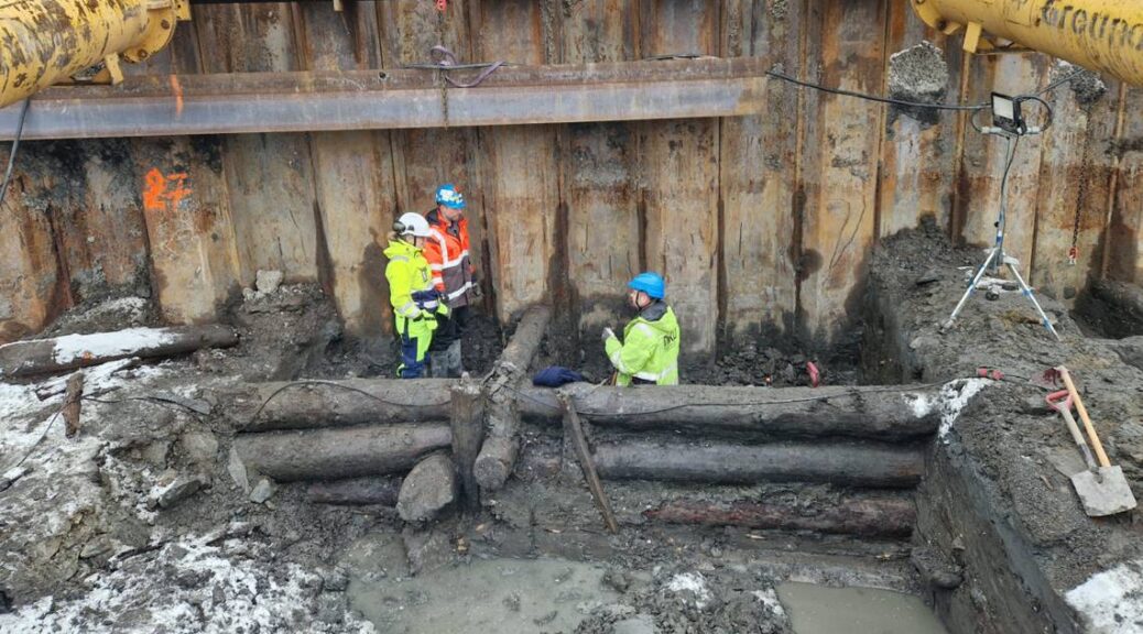
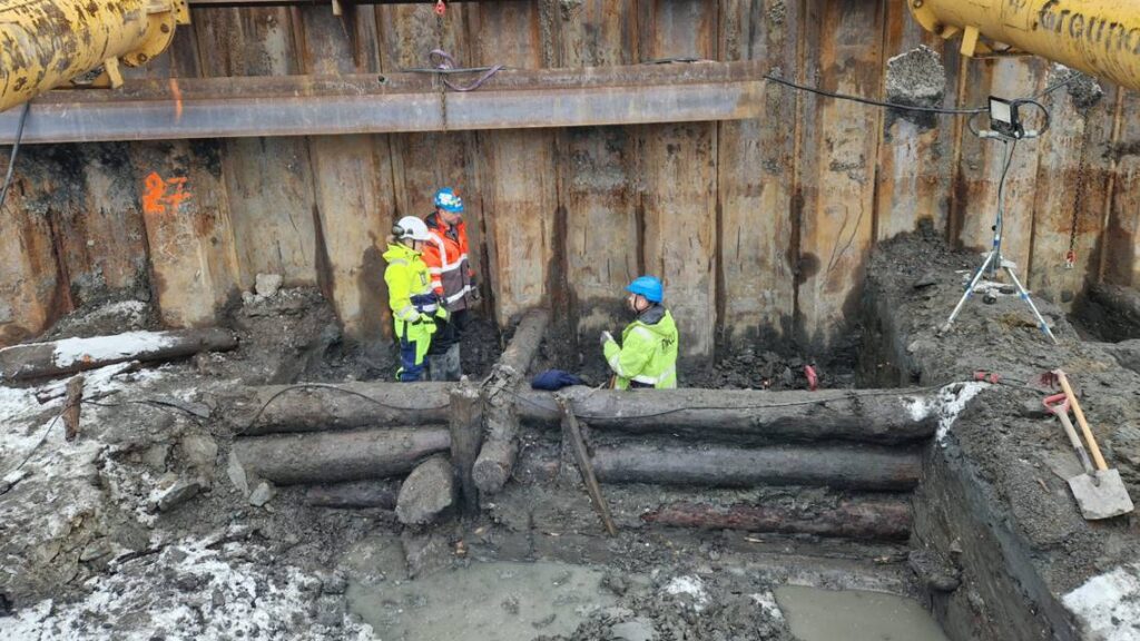
An excavation by NIKU archaeologists in Oslo’s seaside neighborhood of Bjørvika has uncovered the remains of a long section of a medieval wharf believed to have been built by a medieval king of Norway.
Under the dense clay of the Oslofjord seabed, more than 26 feet of the pier’s foundations have persisted in excellent condition.
Archaeologists knew from preliminary surveys that something was buried at a port in Oslo, the Norwegian Institute for Cultural Heritage Research (NIKU) said in a Thursday, March 2, news release. The ruins of a medieval wharf were discovered when excavations got underway.
The wharf consisted of massive logs lashed together to form bulwarks. The logs were dotted with impressions of barnacles and mussels, signs of having once been exposed to the sea.
Over time, the structures built on top of the foundations pressed them deeper into the clay, where they remained even after the surface structures were lost.
The pier was most likely built in the early 14th century and has since sunk into the clay seabed under its own weight, according to the release.
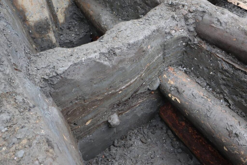
A close-up photo of the accumulated layers of clay.
Archaeologists believe this wharf was probably the king’s, based on its location and estimated age. Another nearby dock is known to have been used by royalty from the 11th to 13th centuries, according to the release.
A small mystery is that archaeologists unearthed layers of food waste, fish bones, dung, and peat in the clay around the massive logs. Archaeologists don’t know how these materials ended up around the pier.
“This is very mysterious,” says Håvard Hegdal, archaeologist and project manager from NIKU, “How has this come into what has been a closed construction? There has been a floor above us, and probably a building, and it shouldn’t be possible to throw food scraps and other things down here.”
“There was also a lot of dirt from a boat inside these layers. And it shouldn’t have come in here in any case. So ‘King’s wharf’ may have had a reasonably short lifespan, and that is quite strange.”
Researchers will cut a portion of the wood off the pier and send it to a lab to be more specifically dated dendrochronologically, the release said.
The most likely candidate to build the wharf was Haakon V (reigned 1299–1319). Oslo overtook Bergen to become the capital of Norway during his reign, and Haakon had the Akershus Fortress built to protect the city and serve as a royal residence. The pier’s foundations were discovered right next to the ruins of the royal palace that stood before Akershus Fortress.
The remains of the wharf have been scanned to create a 3D model. And excavations are ongoing.
Archaeologists have discovered sandstone blocks belonging to a pharaoh’s temple covered with hieroglyphs in Sudan
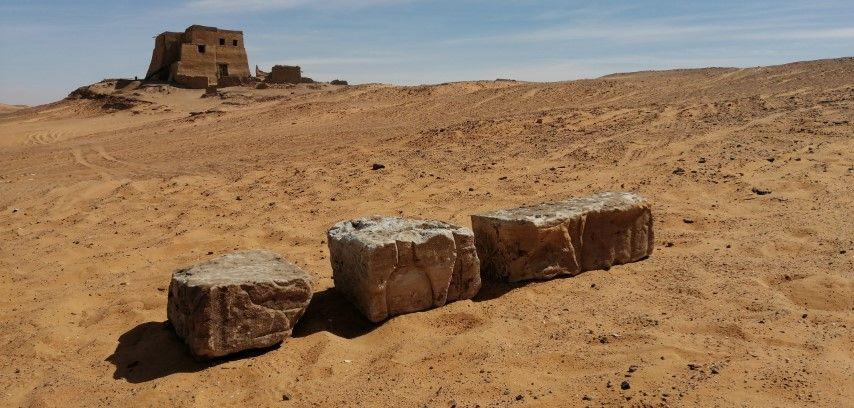
Polish archaeologists have discovered sandstone blocks belonging to a pharaoh’s temple covered with hieroglyphs during excavations at Old Dongola in Sudan.
Recent excavations have uncovered over 100 blocks of white sandstone, inscribed with Ancient Egyptian hieroglyphics from the period of the 25th dynasty of Egypt, also known as the Nubian Dynasty.
The blocks found in Old Dongola were originally part of a structure, possibly a temple, built in the first half of the 1st millennium BC, which is the earliest example of human activity on a site identified so far.
Egyptologist Dr. Dawid F. Wieczorek said: “This is a huge discovery, because despite the 60-year Polish archaeological presence in Old Dongola, no evidence of such early construction activity on the site has been identified so far.
It is impossible to say whether this material is local or was brought from some other site. Nevertheless, it is surprising that there are so many of these blocks, and from different parts it seems of the same temple.”
Some of the blocks are from the flooring, outer walls, and from a pylon (a tower flanking the entrance to the temple). “This would push back the known history of this city by over 1000 years,” said Dr. Wieczorek.
Within a radius of more than 100 kilometers from Old Dongola, there are no other known examples of sites with Egyptian-style architecture.
The closest is Gebel Barkal (about 150 km up the Nile), and Kawa (about 120 km down the Nile). Both were leading urban and religious centers established during the New Kingdom in the 16th and 14th centuries BC.
The Kushite king Kashta came to Egypt amid political turmoil to run for the office of pharaoh, apparently in Thebes and apparently peacefully.
He was the first of the Nubian line of kings who ruled as the 25th dynasty of Egypt (747–656 BC). Piye, the next king, led the conquest of Egypt into the Nile Delta, reacting dramatically to the threat of a combination of powerful northern dynasty. He created an empire that stretched from the 6th cataract to the Mediterranean Sea.
The Kushite rulers presented themselves as pharaohs who could return Egypt to its former glory. They assimilated into society by reaffirming Ancient Egyptian religious traditions, temples, and artistic forms, while introducing some unique aspects of Kushite culture.
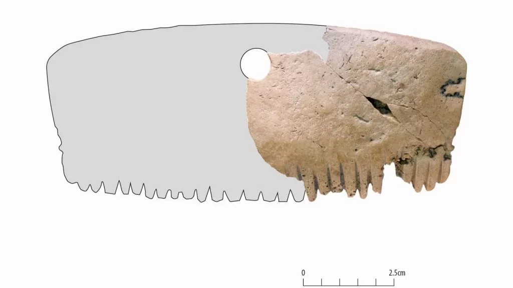
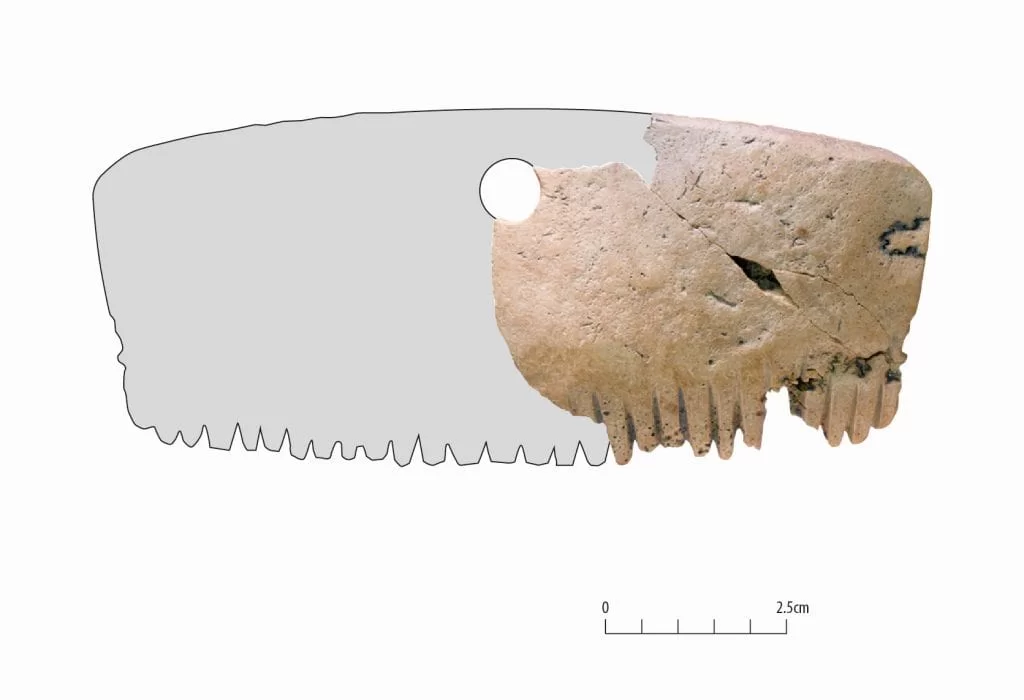
Iron Age comb found made from a human skull in the UK
Researchers from the London Archaeological Museum (MOLA) determined that an Iron Age comb they found during an archaeological dig that ended in 2018 was made from a human skull and was most likely used as a talisman rather than styling hair.
The accessory dubbed the Bar Hill Comb was among 280,000 items of interest collected between 2016 and 2018 during the A14 improvement scheme.
The comb is around 2 inches long with a curved top and teeth carved into the bottom.
The reconstruction drawing created by the MOLA researchers suggests that the comb was originally rectangular with a circle carved out in the middle for attaching to clothing.
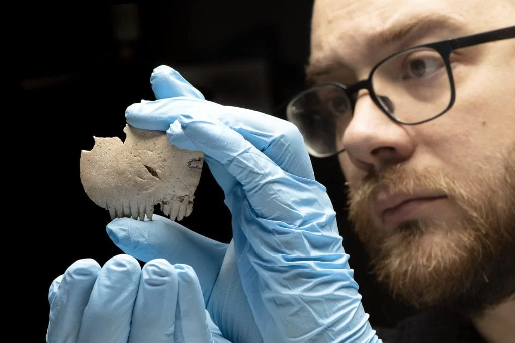
“The Bar Hill Comb may have been a highly symbolic and powerful object for members of the local community,” Michael Marshall, a prehistoric and Roman finds specialist at MOLA said in a statement.
MOLA Find specialist Michael Marshall examining the Bar Hill comb.
“It is possible it was carved from the skull of an important member of Iron Age society, whose presence was in some way preserved and commemorated through their bones.”
He said only two other comparable examples have ever been found in Britain – both within 15 miles (24km) of the Bar Hill Comb.
The lack of wear on the comb’s teeth distinguishes this bone from other finds, suggesting that it was possibly worn as an amulet rather than used to brush the hair at all.
Many people in the British Isles during the Iron Age revered human skulls, according to historians.
Both carved stone heads and skulls served as talismans, as evidenced in ritual practices documented by archaeologists and in folklore.
The comb’s tines show no signs of use or deterioration, and traces of a hole that was drilled into its top indicate that it was once attached to a string for wearing.
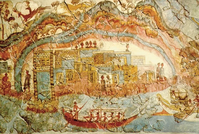
Minoan civilization may have used celestial navigation techniques
According to a study done by an American researcher at the University of Wales, ancient civilizations may have used celestial navigation methods to travel.
Alessandro Berio, a skyscape archaeologist, discovered new evidence that the ancient Minoan civilization developed significant nautical technologies to aid in international sea trade, which is linked to the wealth and expansion of the culture throughout the Mediterranean.
Because of its location, Minoan culture was based on open sea navigation and international trade cycles.
The Minoan civilization may have relied heavily on celestial star paths above to help them navigate the Mediterranean.
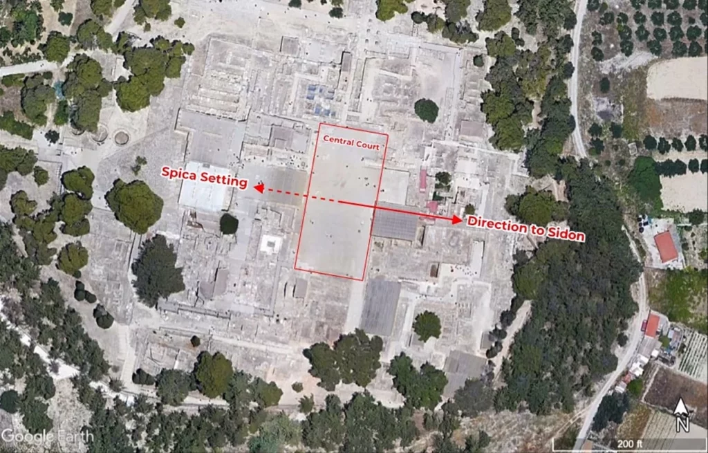
According to a study, the Minoan palaces were even placed to face the rising or setting of a few notable stars, serving as their guide to important commercial centers.
“It is hypothesized that the orienting of palatial architecture toward star paths and specific sea lanes may have symbolized the special relationships between the palaces and distinct foreign emporia, while also being a source of legitimization of power for the local elite who controlled the ideological and technological frameworks of maritime knowledge,” Berio wrote in the paper.
Berio focused his research on the Minoan civilization, a Bronze Age Aegean people who lived on the island of Crete between 2600 – 1100 BC.
The Pelusiac branch of the River Nile was exactly parallel to the central court of the Minoan trading post. The study found that Knossos, the largest Minoan palace, was perfectly positioned on a “star path” with the constellation of Virgo and the commercial center of Sidon.
This alignment may have played a critical role in guiding Minoan sailors to critical trading destinations in Egypt and the Levant.
Indeed, the orientation of various palaces toward specific star paths and sea lanes may have symbolized the unique relationship between these palaces and distinct foreign commercial hubs. Furthermore, they may have legitimized the power of the ruling elite, who controlled maritime navigation knowledge and technology, as well as specific sea routes.
The research discovered that Minoan sailors may have used star paths or linear constellations to guide them to Mediterranean cities where Minoan artifacts and frescoes bear evidence of trade links between them.
The discovery could call into question the previous theory that Homer’s Odyssey was the first historical signal of celestial navigation. We now have more evidence that we need to rewrite history and push back the timeline of human development.
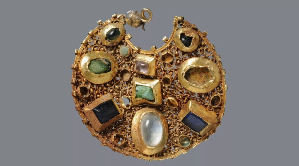
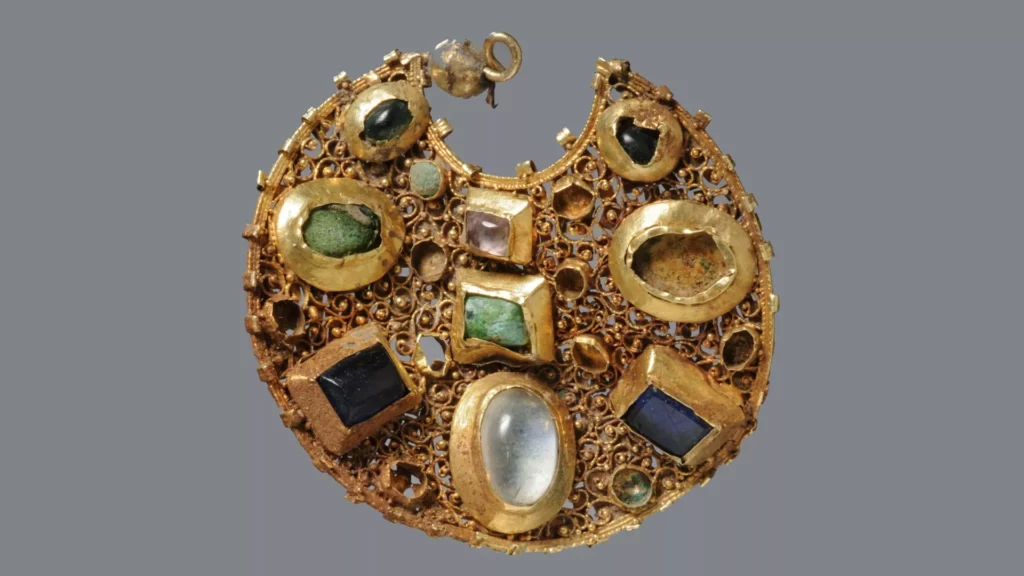
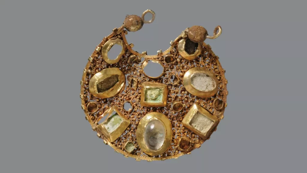
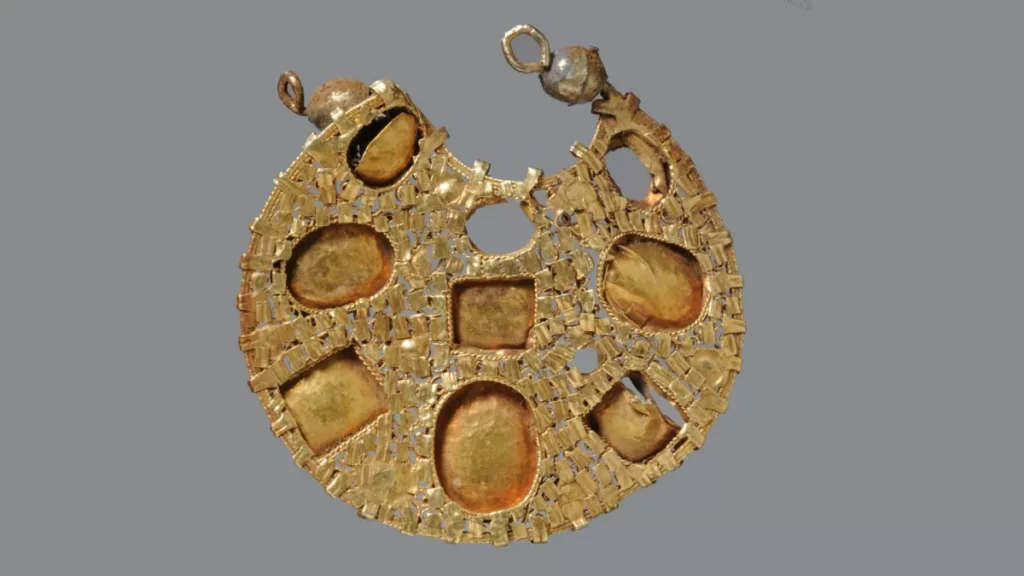
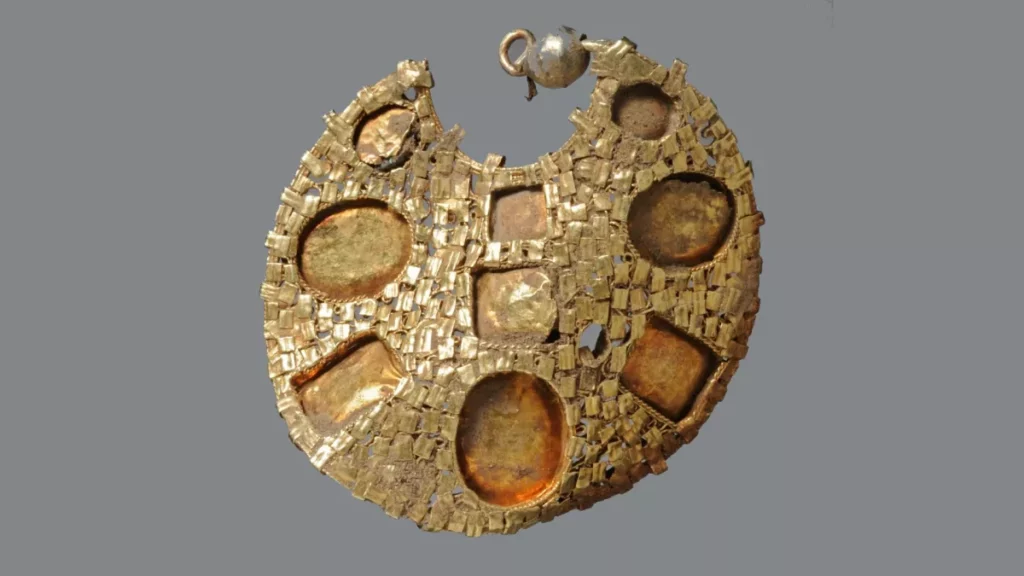
The front of one gold earring in the Byzantine style that a metal detectorist found in Germany.
A trainee metal detectorist in northern Germany recently hit on something his mentor never expected: an 800-year-old hoard of gold jewelry and silver coins that hints at the area’s trade connections.
The large hoard contained a dazzling collection of artifacts. “The hoard consisted of two very high-quality gold earrings set with semi-precious stones, a gilded pseudo-coin brooch, two gilded stone-studded finger rings, a ring fragment, a small formerly gilded perforated disc, a ring brooch, and about 30 silver coins, some of them heavily fragmented,” Ulf Ickerodt, director of the State Archaeological Department of Schleswig-Holstein (ALSH), told Live Science in an email.
For decades, amateur and professional archaeologists have been working together to investigate the region of Schleswig-Holstein, and in particular the UNESCO world heritage site of Haithabu.
Known as Hedeby in Danish, the site was the second-largest Nordic town and was important to the Vikings between the eighth and 11th centuries.
Haithabu was destroyed and abandoned around 1066, ending the Viking era in the region, but a century or two later someone purposefully buried the bag full of valuables nearby.
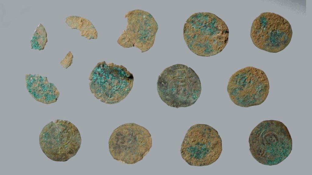
A selection of silver coins was found in the hoard. They date to the time of King Valdemar II.
The detectorists came across the hoard while walking a well-studied patch of land. They reported the find to the ALSH, and a team of archaeologists then excavated the site to reveal items including silver and gold objects with preserved textile fragments adhering to them.
Perhaps the most remarkable items in the hoard are the two earrings. “They probably date to the time around and after 1100 and are in the tradition of Byzantine goldsmiths,” Ickerodt said.
The hoard also contained an imitation of an Islamic coin — an Almohad gold dinar — that had been made into a brooch. The Almohad caliphate was a Muslim dynasty that ruled over southern Spain and northern Africa between the 12th and 13th centuries.
The 30 silver coins, minted during the time of Danish King Valdemar II, suggest that the hoard was buried sometime after 1234.
The front of the second gold earring in the Byzantine style.
The back of the second gold earring in the Byzantine style
The back of one gold earring in the Byzantine style.
The combination of Danish coins and western Mediterranean jewelry is particularly interesting and hints at the cosmopolitan nature of the area.
“Islamic coins were well known in southern Scandinavia between the 9th and 11th centuries,” Marjanko Pilekić, a numismatist in Germany who was not involved in this study, told Live Science by email.
The money may have “reached this area en masse through long-distance trade contacts, robbery, tribute, among others,” he said. “It was a popular practice to pierce or loop the coins and wear them.”
A gilded pseudo-coin fibula. This imitation Islamic coin was fashioned into a brooch.
The discovery of hoards is rare in Schleswig-Holstein, and it’s unclear whether these items were personal property or stolen, if they were meant to be delivered to someone else, or if they were buried for ritual reasons.
“Especially in times of crisis,” Ickerodt said, “the resulting danger leads to the hiding of possessions.” The Haithabu area was not abandoned for long after its destruction in the mid-11th century.
Across the inlet of Schlei, Schleswig had begun developing as a settlement and trading center. “An extensive north-south and east-west trade network have developed here since the early Middle Ages, in which the Mediterranean region, the North Sea, and the Baltic Sea were integrated,” Ickerodt said. “The hoard was certainly not put down by chance.”
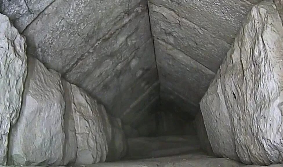
Camera Glimpses Hidden Corridor in Egypt’s Great Pyramid
Video footage from an endoscope showed an empty corridor with a vaulted ceiling
Egyptian antiquities officials say they have confirmed the existence of a hidden internal corridor above the main entrance of the Great Pyramid of Giza.
Video from an endoscope showed the inside of the corridor, which is 9m (30ft) long and 2.1m (7ft) wide.
The officials say it could have been created to redistribute the pyramid’s weight around the entrance or another as yet undiscovered chamber.
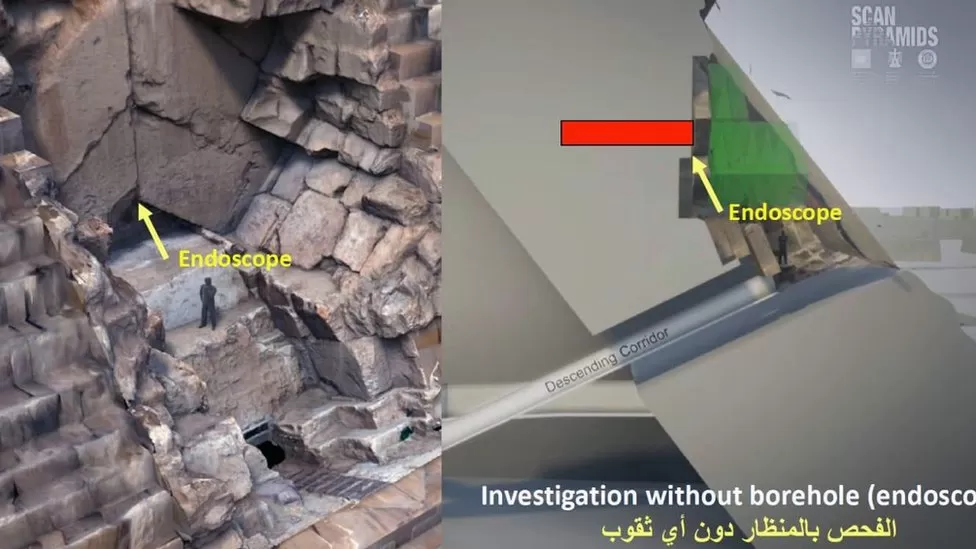
It was first detected in 2016 using an imaging technique called muography.
The non-invasive technique detected an empty space behind the northern face of the Great Pyramid, about 7m above the main entrance, in an area where there is a stone chevron structure.
Further tests were carried out with radar and ultrasound before a 6mm-wide (0.24in) endoscope was fed through a tiny joint in-between the stones that make up the chevrons.
The endoscope was pushed into the empty space behind a chevron structure on the pyramid’s wall
The footage from the camera was unveiled at a news conference beside the pyramid on Thursday. It showed an empty corridor with walls made out of roughly-hewn stone blocks and a vaulted stone ceiling.
“We’re going to continue our scanning so we will see what we can do… to figure out what we can find out beneath it, or just by the end of this corridor,” said Mostafa Waziri, head of Egypt’s Supreme Council of Antiquities.
The Great Pyramid, which is 146m high, was built on the Giza plateau during the fourth dynasty by the pharaoh Khufu, or Cheops, who reigned from around 2609BC to 2584BC.
Despite being one of the oldest and largest monuments on Earth, there is no consensus about how it was built.
The Great Pyramid, seen in the background, is the largest of the three pyramids located at Giza
Egyptian archaeologist Zahi Hawass said the corridor represented a “major discovery” that would “enter houses and homes of people all over the world for the first time”.
He also said that it might help reveal whether the burial chamber of King Khufu still existed inside the pyramid.
He speculated that there might be “something important” in the space below the corridor, then added: “I’m sure in a few months from now we can see if what I’m saying is correct or not.”
Signs of Surgery Examined on Medieval Woman’s Skull
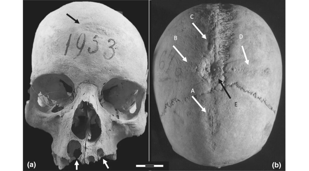
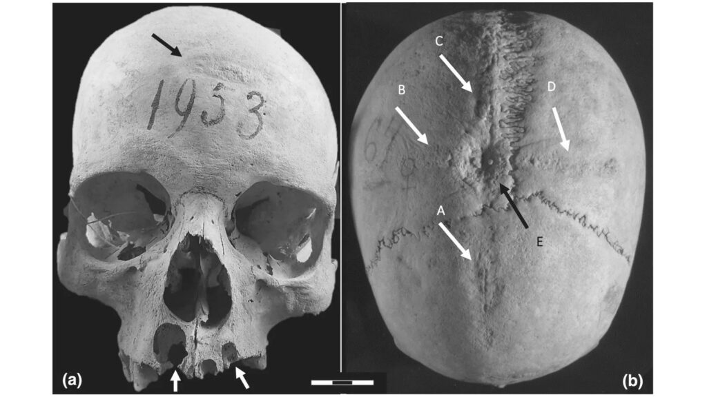
The woman’s skull shows clear traces of a large cross-shaped incision in the top, with a partially-healed oval of bone at the center; and a patch on her forehead where the bone has been scraped thin. Researchers think both are evidence of trepanations, possibly in an attempt to cure extreme pain she was suffering from two large abscesses on her upper jaw.
The skull of an early medieval woman found in Italy shows signs of two trepanations – surgeries for making holes in the head.
There were several reasons for trepanation, but in this case, the procedures seem to have been attempting to remedy an illness, researchers reported in a new study. However, they couldn’t determine exactly what that illness was.
“We suppose that this individual died from pathologies that may have been related to her condition,” Ileana Micarelli, a bioarchaeologist at the University of Cambridge, told Live Science. “But we are not certain about the reason.” Micarelli is the lead author of the new study, published Jan. 23 in the International Journal of Osteoarchaeology, part of which she wrote as a doctoral student at the Sapienza University of Rome.
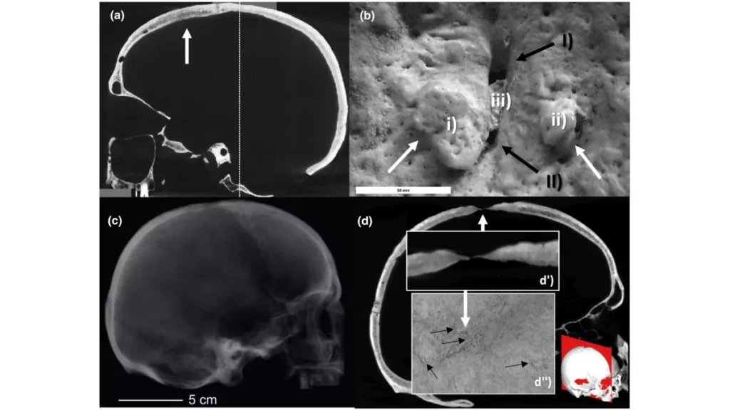
The skull’s most remarkable features, according to the study authors, are traces of a huge cross-shaped incision that show that most of the skin of the woman’s scalp was peeled back, with a partially healed oval of bone at its center that seems to be the result of a trepanation performed up to three months before she died.
Lombard castle
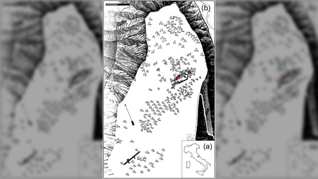
The skull is one of 19 that have survived since excavations in the 19th century of an early medieval cemetery at Castel Trosino in central Italy. The castle was a Lombard stronghold from the sixth until the eighth centuries A.D.
The woman’s skull was found in the 19th century during excavations at a cemetery at Castel Trosino in central Italy, about 80 miles (130 kilometers) northeast of Rome.
From around the sixth to eighth century A.D., Castel Trosino was a stronghold of the Lombard people — Germanic invaders who established a kingdom in Italy after the fall of the Roman Empire — and the researchers think this woman was a wealthy Lombard.
Although hundreds of burials were found during the excavations, just 19 skulls have survived. The rest of the woman’s skeleton is lost, which complicates any modern analysis, Micarelli said.
As well as the cross-shaped incision, the skull shows clear signs of a second surgery, when the bone behind the woman’s forehead was scraped thin after the skin there was peeled back. This appears to have been an attempt at a second trepanation, Micarelli said. There is also evidence that the woman died before the second procedure could be completed: The patch of scraped bone doesn’t go all the way through the skull, and there is no sign that it ever healed, Micarelli said.
But the new scientific analysis doesn’t show any reason why this woman would have voluntarily undergone both of these extreme surgeries, which must have been painful, although painkillers from plants were known of at the time, she said.
Micarelli speculated that the woman may have suffered extreme pain from two large abscesses on her upper jaw, which could have spread the infection to her brain. “We can imagine that these were quite painful as well,” she said.
Ancient Remedy
The researchers made silicone molds of the scars on the bones of the skull, and then used the molds to make casts with epoxy resin that they could study.
Computed tomography (CT) scans show that a hole at the top of the woman’s skull was scraped through the entire bone, but had partially healed; while the scraped patch of bone on the woman’s forehead had not completely penetrated her skull before she died.
Bioarchaeologist Kent Johnson, an associate professor of anthropology at the State University of New York, Cortland who wasn’t involved in the study, said there is evidence that trepanations have been carried out for thousands of years. “The practice of trepanation is seen on almost every continent, wherever people have lived,” he told Live Science. “It’s a long-standing and pretty widespread practice.”
In most cases, trepanation was performed in an attempt to cure an ailment and mainly to alleviate trauma to the skull, such as swelling of the brain caused by a blow to the head, Johnson said. However, some scholars have suggested that the surgery sometimes had a ritual purpose.
Indeed, Micarelli and her colleagues considered that the trepanations on the Castel Trosino skull may have been performed for cultural reasons — something is seen among the Avar people in the Carpathian Basin (parts of modern-day Hungary and Romania) in the early medieval period — or as a judicial punishment. However, the study authors ruled out both of those ideas in the case of the Lombard woman’s skull.
In fact, it’s possible that the incisions were not from trepanation at all, said John Verano, an anthropologist and professor at Tulane University and author of “Holes in the Head: The Art and Archaeology of Trepanation in Ancient Peru” (Dumbarton Oaks, 2016) who wasn’t involved in the Castel Trosino research.
He suggested that what Micarelli and her colleagues interpreted as a trepanation on the top of the skull may instead have been an attempt to scrape away infected bone.
“I [have] never seen a trepanation like this, if indeed it is a trepanation,” he told Live Science in an email. “This is a complex case with multiple possible scenarios to explain the bone reaction.”
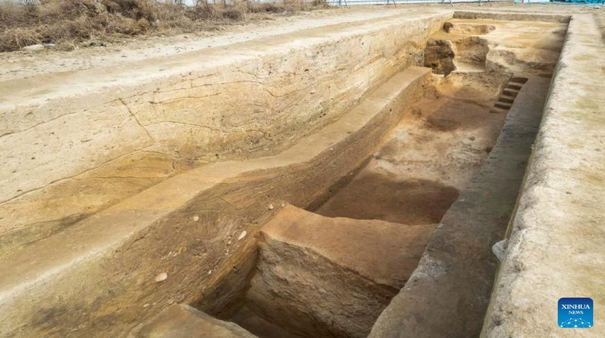
6,000-year-old defensive trench unearthed in China’s Henan
A defensive trench dating back around 6,000 years has been discovered at a relics site in central China’s Henan Province, according to the municipal institute of archaeology of Luoyang City.
The semi-annular trench, located at the Suyang relics site in Yiyang County, was dug manually, and the shape and structure reflected the powerful and orderly social organization ability and technical level at that time, said Ren Guang, who is in charge of the excavation of the site.
Based on unearthed relics and the accumulated layers in the trench, archaeologists believe that the trench had gone through three periods of the Yangshao Culture, dating back 5,000 to 7,000 years.
By the late period of the Yangshao Culture, the trench had probably lost its defensive function, as a number of house sites, ash pits, and production and household relics from this period were found on both sides of the trench, Ren said.
Rows of wooden posts that may have been used to protect the trench reflected the re-use of the abandoned facility by people at that time, Ren added.
Pottery, stone, jade, bone and mussel wares were also found at the site, as well as a few well-preserved remains of carbonized corn and millet.
Archaeologists initiated the Suyang relics site excavation work in early 2021.