All posts by Archaeology World Team

‘Entire Streets’ Of Roman London Uncovered

‘Entire Streets’ Of Roman London Uncovered

About 10,000 finds have been discovered, including writing tablets and good luck charms. The area has been dubbed the “Pompeii of the north” due to the perfect preservation of organic artefacts such as leather and wood.

Experts uncovering a 2,000-year-old Roman tiled floor

One expert said: “This is the site that we have been dreaming of for 20 years.”

Archaeologists expect the finds, at the three-acre site, to provide the earliest foundation date for Roman London, currently AD 47.

‘Entire Streets’ Of Roman London Uncovered
The site is providing fresh insight into the religious and mystical practices of London’s early residents. Amber was an expensive imported material and was thought to have magical powers and this amulet, in the shape of a gladiator’s helmet, may have been used to protect children from illness
View to northwest of the Bloomberg Place site, recording a 4th-century Roman timber well

The site will house media corporation Bloomberg’s European headquarters.

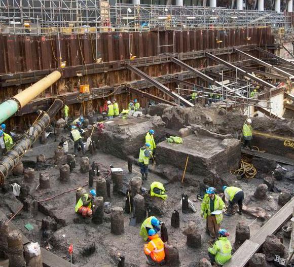
It contains the bed of the Walbrook, one of the “lost” rivers of London, and features built-up soil waterfronts and timber structures, including a complex Roman drainage system used to discharge waste from industrial buildings.

Organic materials such as leather and wood were preserved in an anaerobic environment, due to the bed being waterlogged.

‘Beautifully preserved’

Museum of London archaeologists (MOLA), who led the excavation of the site, says it contains the largest collection of small finds ever recovered on a single site in London, covering a period from the AD 40s to the early 5th Century.

An amber amulet in the shape of a gladiator’s helmet was discovered

Sadie Watson, the site director for MOLA, said: “We have entire streets of Roman London in front of us.”

At 40ft (12m), the site is believed to be one of the deepest archaeological digs in London, and the team has removed 3,500 tonnes of soil in six months.

More than 100 fragments of Roman writing tablets have been discovered. Some are thought to contain names and addresses, while others contain affectionate letters.

More than 100 fragments of the wooden tablet have been preserved and they contain fascinating information about Roman life. This tablet is a letter to a friend. Tablets of this sort were used for everyday correspondence and even shopping lists or party invitations.

A wooden door, only the second to be found in London, is another prized find.

MOLA’s Sophie Jackson said the site contains “layer upon layer of Roman timber buildings, fences and yards, all beautifully preserved and containing amazing personal items, clothes, and even documents.”

The site also includes a previously unexcavated section of the Temple of Mithras, a Roman cult, which was first unearthed in 1954.

The preserved timber means that tree ring samples will provide dendrochronological dating for Roman London, expected to be earlier than the current dating of AD 47.

The artefacts are to be transported back to the Museum of London to be freeze-dried and preserved by the record, as the site will eventually become the entrance to the Waterloo and City line at Bank station.

These 4th Century pewter bowls and cups are examples of fine tableware and were thrown into a timber-lined well as part of a ritual offering, along with some cow skulls. Once experts have managed to record all the finds, they will form part of a public exhibition in the new building.

18th century Ice House re-discovered beneath the streets of Marylebone London

18th century Ice House re-discovered beneath the streets of Marylebone London

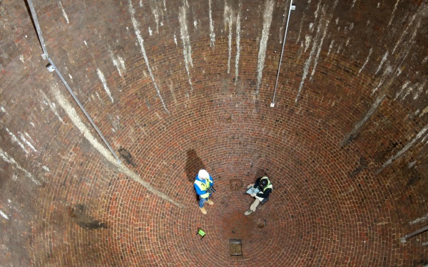
Archaeologists in London have re-discovered a subterranean ice house near Regents Park. Dating back to the 1780s, the egg-shaped cavern was used to store ice, which was imported from as far away as Norway.

18th century Ice House re-discovered beneath the streets of Marylebone London
18th century Ice House re-discovered beneath the streets of Marylebone

Made from bricks, the structure would have been one of the largest of its kind at the time, according to the Museum of London Archaeology (MOLA).

The egg-shaped chambers measure 25 feet (7.5 meters) wide and 31 feet (9.5 meters) deep. Archaeologists with MOLA found the ice house, also known as an ice well, along with its entrance chambers and vaulted ante-chamber, during preparation for the development of the Regent’s Crescent residential project.

A MOLA archaeologist brushes off the exterior of the ice house.

MOLA said the ice houses are in remarkable condition, given that buildings directly above it were destroyed during the London Blitz of the 2nd World War, and that a subway line runs about 32 feet (10 meters) underneath, as the Guardian report.

It is hard to believe that a structure as large as this could have gone missing, but the entrance was buried during clean-up operations after the Blitz.

“There was always an understanding that there was an ice house here somewhere, but we were not sure where,” David Sorapure, the head of Built Heritage at MOLA, told the Guardian.

“Even after we found where the entrance was, we were not quite sure how big it was, or how you got in.”

MOLA is working at the site on behalf of Great Marlborough Estates, which is currently redeveloping Regent’s Crescent, which once boasted elaborate stucco terraces designed by architect John Nash, who also designed Buckingham Palace.

The ice well was built underneath the terrace in the 1780s by Samuel Dash, who had ties to the brewing industry. By the 1820s, ice-merchants and confectioner William Leftwich was using the Ice Houses to store and supply ice for wealthy Londoners, according to MOLA.

Schematic of the ice house.

While modern refrigeration had yet to be invented, that did not deter Englanders from wanting easy access to ice.

It was not possible back then to create ice artificially, so it had to be gathered from local waterways and stored in subterranean ice houses, of which there were thousand in London alone (though much smaller than the newly discovered ice house).

As the Guardian reports, workers at the ice house would descend into the chambers to collect pieces of ice when needed. The ice would have been delivered to customers, including restaurants and potentially doctors and dentists, via a horse-drawn cart.

While we may take access to ice for granted today, the frozen stuff was in high demand in Leftwich’s day. According to a MOLA press release:

Leftwich was one of the first peoples to recognise the potential for profit in imported ice: in 1822, following a very mild winter, he chartered a vessel to make the 2000 km round trip from Great Yarmouth to Norway to collect 300 tonnes of ice harvested from crystal-clear frozen lake, an example of “the extraordinary the length has gone to at this time to serve up luxury fashionable frozen treats and furnish food trader and retailers with ice” (as put by David Sorapure, our Head of Built Heritage).

The venture was not without risks: previous import had been lost at sea or melted whilst baffled custom officials dithered over how to tax such novel cargo.

The newly re-discovered ice houses have now been designated a Scheduled Monument by Historic England. Restoration work is planned for the structures, along with the construction of a viewing corridor to allow public access.

Norwegian ice cutters handle blocks of ice harvested from frozen lakes, circa 1900.

Archaeologists discover a medieval skeleton with his boots still on in London

Archaeologists discover medieval skeleton with his boots still on in London

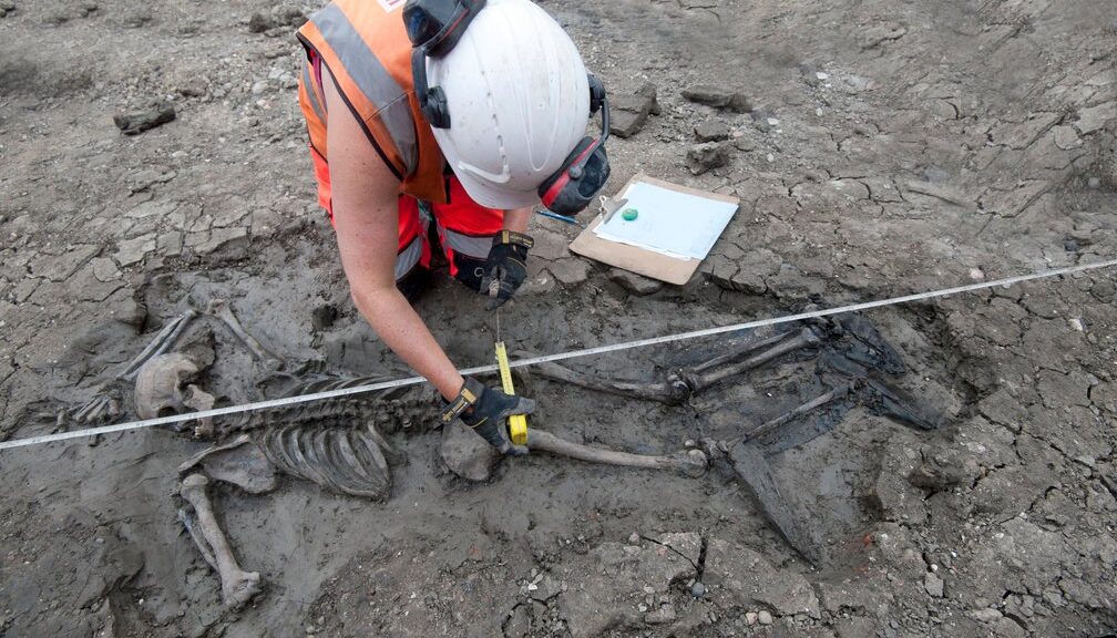
Archaeologists excavating a site along with the Thames Tideway Tunnel—a massive pipeline nicknamed London’s “super sewer”—have revealed the skeleton of a medieval man who literally died with his boots on.

“It’s extremely rare to discover any boots from the late 15th century, let alone a skeleton still wearing them,” says Beth Richardson of the Museum of London Archaeology (MOLA).

“And these are very unusual boots for the period—thigh boots, with the tops, turned down. They would have been expensive, and how this man came to own them is a mystery. Were they secondhand? Did he steal them? We don’t know.”

Unearthing skeletons amid major construction projects is not unusual in London, where throughout the centuries land has been reused countless times and many burial grounds have been built over and forgotten. (Learn more about London’s rich history.)

However, archaeologists noticed right away that this skeleton was different.

The position of the body—face down, right arm over the head, left arm bent back on itself—suggests that the man was not deliberately buried. It is also unlikely that he would have been laid to rest in leather boots, which were expensive and highly prized.

In light of those clues, archaeologists believe the man died accidentally and his body was never recuperated, although the cause of death is unclear. Perhaps he fell into the river and could not swim. Or possibly he became trapped in the tidal mud and drowned.

Sailor, fisherman, or “mudlarker”?

500 years ago this stretch of the Thames—2 miles or so downstream from the Tower of London—was a bustling maritime neighbourhood of wharves and warehouses, workshops and taverns.

The river was flanked by the Bermondsey Wall, a medieval earthwork about fifteen feet high built to protect riverbank property from tidal surges.

Given the neighbourhood, the booted man may have been a sailor or a fisherman, a possibility reinforced by physical clues.

Pronounced grooves in his teeth may have been caused by repeatedly clenching a rope. Or perhaps he was a “mudlarker,” a slang term for those who scavenge along the Thames muddy shore at low tide.

The man’s wader-like thigh boots would have been ideal for such work.

“We know he was very powerfully built,” says Niamh Carty, an osteologist, or skeletal specialist, at MOLA.

“The muscle attachments on his chest and shoulder are very noticeable. The muscles were built by doing lots of heavy, repetitive work over a long period of time.”

It was work that took a physical toll. Albeit only in his early thirties, the booted man suffered from osteoarthritis, and vertebrae in his back had already begun to fuse as the result of years of bending and lifting.

Wounds to his left hip suggest he walked with a limp, and his nose had been broken at least once. There is evidence of blunt force trauma on his forehead that had healed before he died.

“He did not have an easy life,” says Carty. “Early thirties was middle age back then, but even so, his biological age was older.”

The examination is continuing. Isotope investigation will shed light on where the man grew up, whether he was an immigrant or a native Londoner, and what kind of diet he had.

“His family never had any answers or a grave,” says Carty. “What we are doing is an act of remembrance. We’re allowing his story to finally be told.”

The boots discovered on the skeleton of a medieval man during Tideway excavations
Grooves in the teeth of the booted man

Bronze Age Burials Found in Sandbox in Poland

Bronze Age Burials Found in Sandbox in Poland

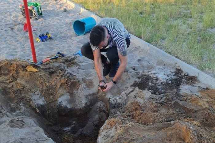
Children playing in a sandpit in southwest Poland discovered human bones inside ancient urns. After local students began digging about with a bucket and shovel just below the pit’s surface in the village of Tuchola arska, the terrible discovery was found.

Bronze Age Burials Found in Sandbox in Poland
The grim discovery was made in the village of Tuchola Żarska after local schoolchildren began digging around with a bucket and spade.

Experts believe the find dates as far back as the Bronze Age and that it comes from the Lusatian culture from around 1100-700 BC.

Local archaeology inspector Marcin Kosowicz said: “While digging in a sandpit, the children came across one or two extensive corpse graves of the Lusatian culture community.

The graves which date back to the Lusatian culture from around 1100-700 BC were found just under the surface of the sand.

“The graves were located very shallowly under the surface of the soil and the overlying sand and for this reason, some of the vessels are fragmented.

“The removal of a considerable part of humus took place during the levelling of the ground for the construction of the playing field with heavy equipment, which could have damaged the vessels.”

He added that the location of the discovery may be linked to an earlier archaeological site nearby which is listed in the provincial heritage protection register.

Kosowicz said: “Due to the fact that its location is marked on a map on a scale of 1:25 000, which is characterised by low precision, it is possible that the grave that the children discovered is closely connected to this site.

“According to local people, a few dozen years ago, during the construction of a pond and a fence on the premises of the neighbouring State Agricultural Farm, bronze artefacts and ceramic vessels were discovered.

“Unfortunately, at this stage, it has not been possible to establish the further fate of these artefacts.”

The Lusatian culture existed in the later Bronze Age and early Iron Age around 1300 BC to 500 BC. The name Lusatia refers to an area in eastern Germany and western Poland.

The Lubusz heritage protection office has said that rescue archaeological excavations will be carried out at the site of the discovery.

Their main aim will be to secure the monuments that have been left behind.

Tenth-Century Church Unearthed in Germany

Tenth-Century Church Unearthed in Germany

Archaeologists searching for a royal palace in Germany have discovered a 1,000-year-old church constructed for Otto the Great (also called Otto I).

An aerial view of the church built for Otto the Great, along with nearby burials, is seen from the southwest.

Otto I, who lived from A.D. 912 to 973, consolidated and expanded the Holy Roman Empire. The empire, which was centred in Germany, controlled territory throughout central Europe.

Historical records indicated that a palace and church were built near Helfta in Saxony for the Roman emperor; and archaeologists with the State Office for Monument Preservation and Archeology Saxony-Anhalt started searching for it in May, they said in a German language statement.

During excavations at the church, archaeologists discovered this enamelled brooch from the ninth century.
Tenth-Century Church Unearthed in Germany
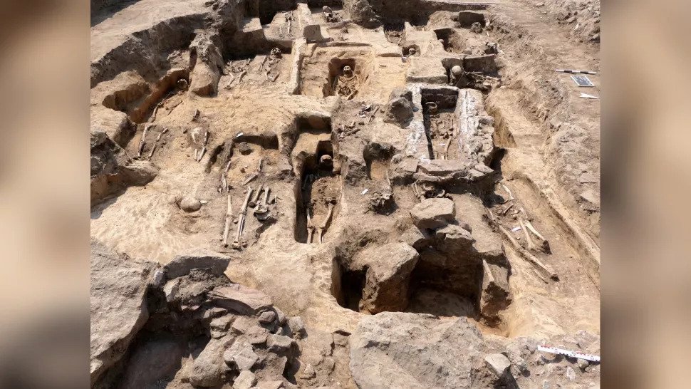
Numerous burials and tombs were found around the church in Germany.

Royal church

The three-aisled church is about 100 feet (30 meters) long and was shaped like a cross, excavations revealed.

The church was destroyed during the Protestant Reformation that swept through Europe in the 16th century and led to the creation of new branches of Christianity, the archaeologists said in the statement.

The church and palace would have “dominated” the valley where they were built, the archaeologists said. 

Among the artifacts found so far is a Romanesque bronze crucifix decorated with enamel that was made in Limoges in New Aquitaine (in modern-day France) in the 13th century, archaeologists said.

Archaeologists also discovered a large fragment of a church bell, an enamelled ninth-century brooch and numerous coins.

The archaeologists have also found several burials around the church, including some tombs made out of bricks.

Excavations and analysis of the remains are ongoing at the site. Right now, excavating the church is a priority, but historical records indicate that the palace is nearby and remains of it may be found as work continues.

Historical records say that while Otto I ordered the construction of the church and a nearby palace, he himself only visited it once when the church was inaugurated around A.D. 968.

The archaeologists noted that Otto I had numerous palaces with nearby churches located throughout his empire.

Felix Biermann, an archaeologist with the State Office for Monument Preservation and Archeology Saxony-Anhalt is leading the excavation team.

Excavation of King Khufu’s Second Solar Boat Completed in Egypt

Excavation of King Khufu’s Second Solar Boat Completed in Egypt

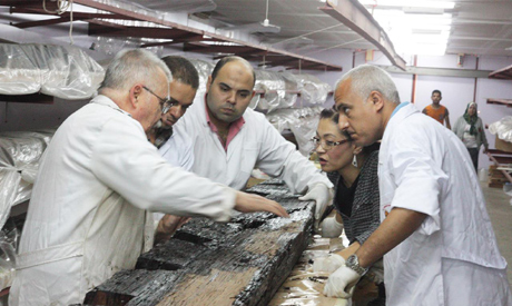
Ahram Online reports that the excavation of the second Khufu solar boat discovered in a pit next to the Great Pyramid of Khufu in 1954 has been completed by a joint Japanese and Egyptian team of researchers.

Sakuji Yoshimura, the head of the Egyptian Japanese archaeological mission and president of Higashi Nippon International University, and Professor Emeritus of Waseda University have completed the excavation of the second Khufu Boat from the pit in which it was discovered beside Khufu pyramid in the Giza plateau.

Issa Zidan, the director-general of executive affairs for restoration at the Grand Egyptian Museum and the supervisor of the restoration work of the second Khufu Boat, explained that nearly 1,700 wooden pieces were extracted from 13 layers inside the pit, noting that the registration and documentation of all pieces have been done, as well as the initial restoration of most of these pieces was completed.

Excavation of King Khufu’s Second Solar Boat Completed in Egypt

He also added that, so far, 1,343 pieces were transferred to the Grand Egyptian Museum, where preparations are underway for starting the second phase that includes the final restoration work, as well as conducting the necessary studies for assembling and re-installing the boat that will be displayed next to the first one inside the new building dedicated for King Khufu’s boats, which is now being constructed at the Grand Egyptian Museum.

Omura Yoshifumi, the chief representative of the Japan International Cooperation Agency (JICA) Egypt Office, said that the JICA will provide a $3 million grant for completion of the final restoration work and reassembly of the boat for its display in the museum, in addition to the $2 million grant that was provided in 2013, which supported the excavation and extracting process of the wooden pieces of the boat from the pit.

The project of restoring and extracting the wooden pieces of the second Khufu Boat is one of the largest restoration projects that represent the aspects of fruitful cooperation between Egypt and Japan, with the support of the JICA.

Cooperation between Egyptians and the Japanese in the Grand Egyptian Museum project started in 2006, when the JICA provided financial support through two soft loans of official development assistance for the construction of the museum at the request of the Egyptian government.

Since 2008, the JICA has been providing technical cooperation through the Egyptian Japanese joint conservation project for the restoration, documentation, packaging, and transfer of 72 artefacts — among which were some of King Tutankhamun’s collection — from the Egyptian Museum in Tahrir and other sites to the Grand Egyptian Museum.

About 90 Japanese experts participated in this project, and a number of high-tech technical equipment were provided within the project, such as a digital microscope, a portable X-ray machine, and an electric forklift to carry heavy artefacts safely.

Ambassador Noke expressed his appreciation for the fruitful cooperation with the Ministry of Tourism and Antiquities led by Minister of Tourism and Antiquities Khaled El-Enany and the sincere efforts of Major-General Atef Moftah — the general director of the Grand Egyptian Museum project — and the surrounding area to realise all this progress, stressing that the Grand Egyptian Museum is a symbol of Egyptian Japanese friendship.

From his side, Yoshifumi expressed appreciation for the Egyptian government’s strong leadership in making such great progress in the Grand Egyptian Museum’s construction and related works towards its opening, emphasising that he is proud that the JICA takes part in preserving the world’s treasures in Egypt to the future generations through this project.

Babylon knew secrets of the solar system 1,500 years before Europe

Babylon knew secrets of the solar system 1,500 years before Europe

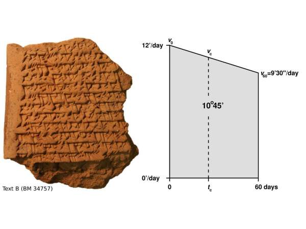
One of the clay cuneiform tablets found in Babylonia and Uruk, showing geometrical calculations for planetary trajectories.

The ancient Babylonians were known to have been advanced in arithmetic. Now analysis of clay cuneiform tablets found in Babylonia and Uruk shows they could predict the position of celestial bodies using advanced geometric techniques thought to have been invented in 14th-century Europe.

Specifically, the tablets show the ancient Babylonians were evidently intrigued by the position of the planet Jupiter, writes Mathieu Ossendrijver of Humboldt University, Berlin, in his paper “Ancient Babylonian astronomers calculated Jupiter’s position from the area under a time-velocity graph”.

The tablets he describes are the earliest known examples of using geometry to calculate the future position of an object in space-time.

Discover the secrets of the Middle East

It is possible that the same techniques were discovered in Oxford, Cambridge, come the 14th century, in a geometric equivalent of convergent evolution (like wings in insects and in birds, which do not have the same origin but look similar and serve the same function). Or, the West may have learned the techniques somehow from the ancient Babylonian astronomers.

The clay tablets, which are practically intact, seem to date between 350 and 50 BCE. There are issues about provenance – Ossendrijver notes that they were “excavated unscientifically” and discuss general methodology, not mentioning specific astronomical phenomena that could be datable.

The writings describe two intervals after Jupiter appears along the horizon, projecting the planet’s position at 60 and 120 days.

The Babylonians had been thought to know only arithmetic concepts, yet these texts contain advanced geometrical calculations.

Babylon knew secrets of the solar system 1,500 years before Europe
A cuneiform tablet with calculations involving a trapezoid.

Geometry began to develop far back in man’s history.

The eminently practical ancient Greeks used geometry to describe configurations in physical space, though it bears saying that the early history of ancient Greek geometry is unknown because no records remain.

Ancient Egyptians also had geometric knowledge, and had command of trigonometry, but were also believed to have confined their use of the science to workday problem-solving, such as calculating the area of a pyramid.

The ancient Babylonians on the other hand left ample records – over 450 relevant tablets, of which some 340 are tables with computations of planetary or lunar data. Another 110 tablets have computational instructions.

We now know they were using geometry in an abstract sense, to define time and velocity, Ossendrijver explains: “In all of these texts, the zodiac, invented in Babylonia near the end of the 5th century BCE, is used as a coordinate system for computing celestian positions.”

So, he concludes, the 14th-century European scholars in Oxford and Paris who had been credited with developing time-velocity geometric predictions were over a thousand years behind their ancient Babylonian peers.

Why would the Babylonians want to calculate the position of Jupiter, anyway? Probably because their priests used astrology to interpret the will of the gods (an alternative method was to “read” the livers of sacrificed animals): Not only time-velocity geometry but celestial divination as an orderly religious practice is believed to have begun with Babylonian culture.

Old Football Found On Beach Turns Out To Be An Iron Age Skull

Old Football Found On Beach Turns Out To Be An Iron Age Skull

Image kicking what you thought was part of an old football during a stroll on the beach – only to discover it was actually part of a human skull. That’s what happened to Anthony Plowright. 

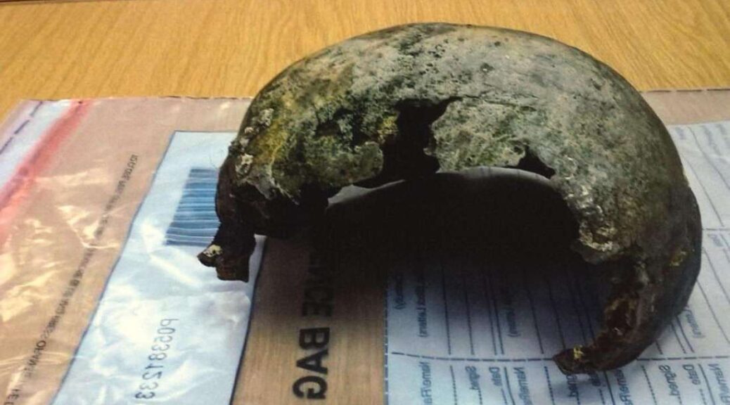
He was walking his two dogs on the beach near Binstead on the Isle of Wight when he discovered what turned out to be the upper part of a human skull, called the cranium.

The Isle of Wight coroners office sent the dark brown remains for carbon dating and discovered it was about 2,800 years old.

Old Football Found On Beach Turns Out To Be An Iron Age Skull
The skull, pictured here, belonged to someone who would have lived in the Iron Age, or about 2,800 years ago according to the Isle of Wight coroners office.
All that remained of the person was the upper part of the skull called the cranium – seen in this photo from the Isle of Wight coroner.

The skull was discovered on the 4th of June 2018 but the Isle of Wight Coroner, Caroline Sumeray has only just released her findings.

The carbon dating puts the cranium as belonging to someone who would have lived in the early Iron Age – between about 800BC and 540BC.

Mr Plowright said: ‘I thought it was part of an old football when I first saw it and so I booted it down the beach. I soon realised it wasn’t a ball.

‘I put it in a bag and took it home and emailed the police to tell them I had found it.’

‘I had absolutely no idea it was that old.’

The skull has been donated to the Isle of Wight Museum Service who say they are looking forward to studying it. 

During the Iron Age, the people of the Isle of Wight were already trading with nearby communities through maritime links.

‘Recent discoveries suggest that the inhabitants of the Isle of Wight engaged in wider maritime activity within the Solent from prehistoric times, according to Stephanie Smith from the British Museum.

‘By the Iron Age and Roman periods, the Island was part of a vast maritime network of interaction between coastal southern Britain and the Continent, extending as far as the Mediterranean.’ 

The skull – pictured – has been donated to the Isle of Wight Museum Service who say they are looking forward to studying it