Hundreds of Well Preserved Prehistoric Animals have been found in an Ancient Volcanic Ashbed in Nebraska
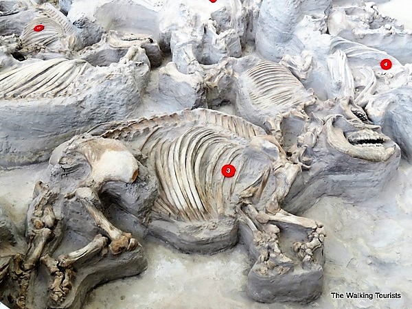
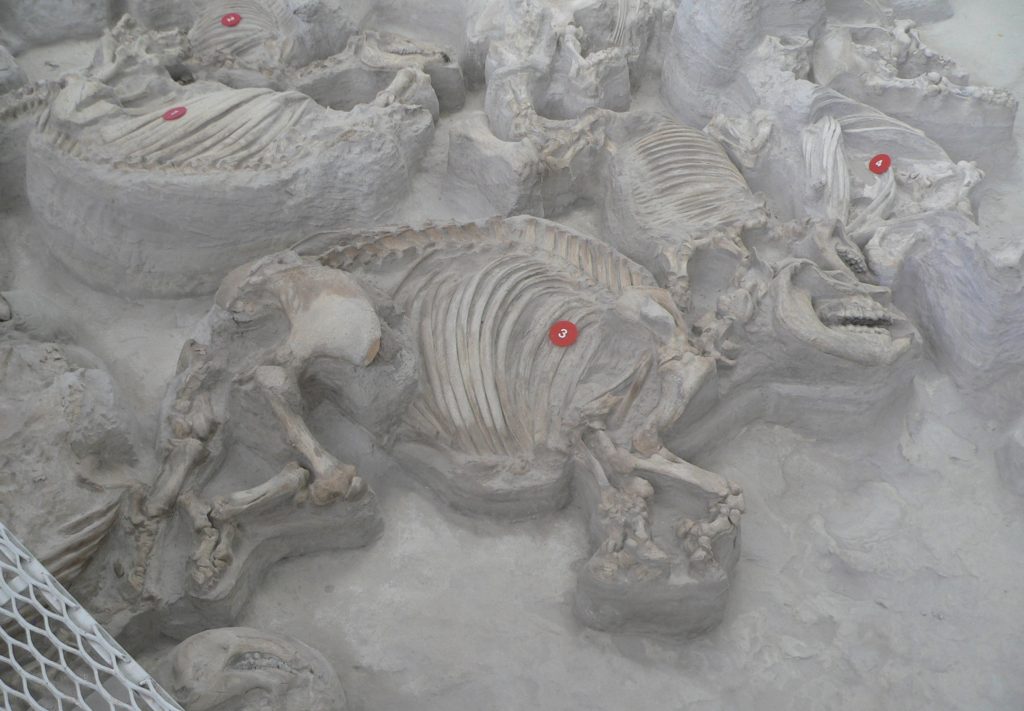
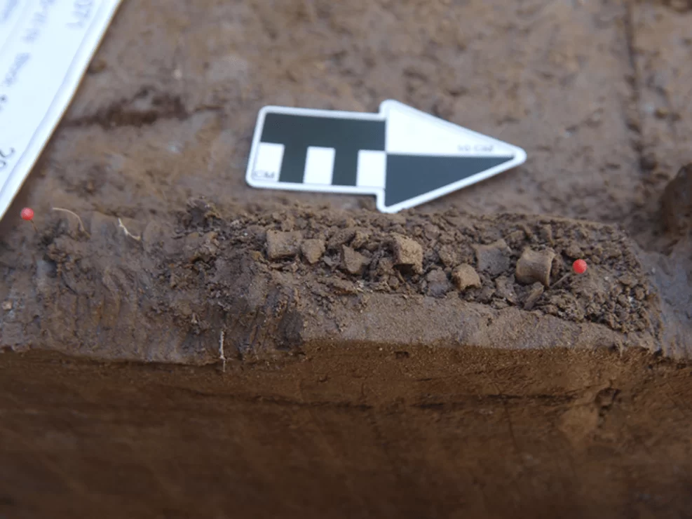
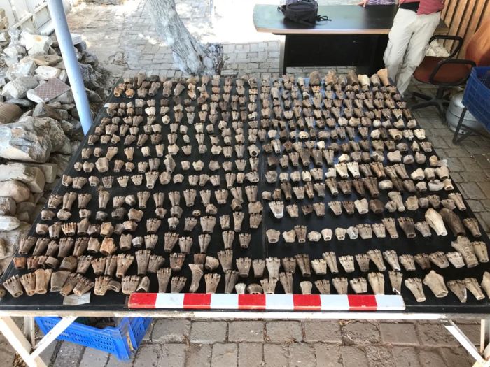
An adult (3) rhino fossil lies next to a baby’s fossils. They are among hundreds of skeletons discovered at Ashfall Fossil Beds State Historical Park in Royal, Nebraska.
The watering holes attracted prehistoric animals among Nebraska’s tall grasslands. From horses to camels and rhinoceroses, with wild dogs looming nearby, animals roamed the savanna-like region.
Then, one day, it all changed. Hundreds of miles away, a volcano in southeast Idaho erupted. Within days, up to two feet of ash covered parts of present-day Nebraska.
Some of the animals died immediately, consumed with ash and other debris. Most of the animals lived for several more days, their lungs ingesting ash as they searched the ground for food. Within a few weeks, northeast Nebraska was barren of animals, except for a few survivors.
More than 12 million years later, a fossil was found in Antelope County, near the small town of Royal.
The skull of a baby rhino was discovered by a Nebraska paleontologist and his wife while exploring the area. The fossil was exposed to erosion. Soon after, exploration started in the area.
As more discoveries were made, the site grew into a tourist attraction. Today, people visit Ashfall Fossil Beds State Historical Park to check out hundreds of fossils from 12 species of animals, including five types of horses, three species of camels, as well as a saber-toothed deer. The infamous saber-toothed cat remains a dream discovery.
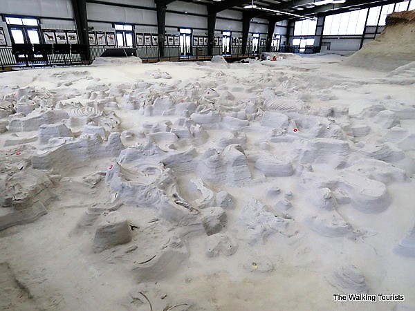
Visitors view fossils inside the Hubbard Rhino Barn, a 17,500-square-foot facility that protects the fossils while allowing visitors to roam on a boardwalk. Kiosks provide information on fossils located in specific areas.
One level of the fossil beds was discovered at Ashfall Fossil Beds Park.
As you tour the barn, if a summer intern or paleontologist is nearby, they are open to discussing their work, as well as answering questions. During our visit, we learned that an intern had discovered a fossilized dog paw print.
Outside the barn, visitors can read facts about the area, including that mammoths migrated to North America about 1.5 million years ago.
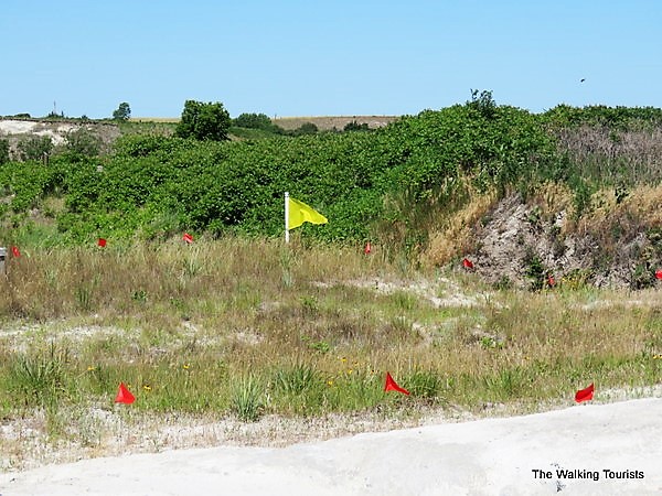
A yellow flag in an area a short distance from the main walk to the barn indicates the discovery site of the rhino skull. Red flags showcase spots where additional fossils were discovered.
A yellow flag marks the site of the first skull discovery in 1971. The red flags indicate spots of additional fossil finds.
Visitor activities and views at Ashfall Fossil Beds
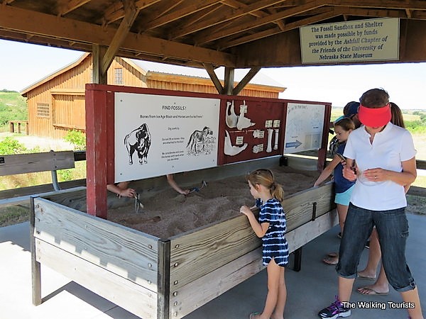
In addition to the Hubbard Barn, Ashfall Fossil Beds features a discovery area where children can cipher through the sand searching for their own fossil discoveries. A small barn is used for special exhibits, as well as classes.
Children play in a sandbox “searching” for fossils.
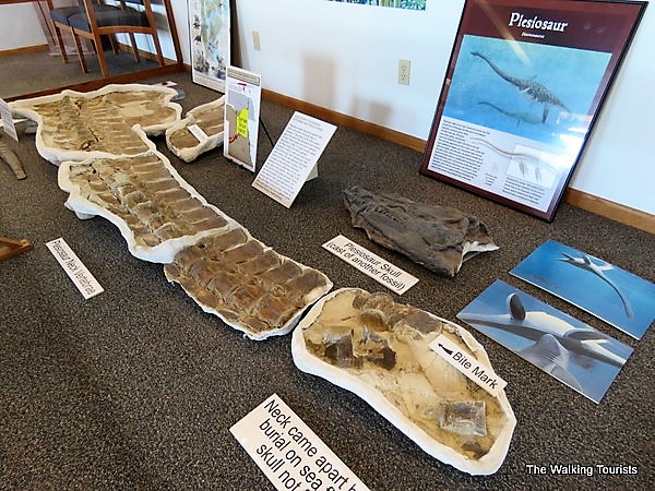
The visitors center houses some animal remains, as well as paleontologists working on recent finds. About 60 million years before the area was home to the savanna, Nebraska was part of a tropical sea.
Fossils found in the area include a plesiosaur, a mammal from the Jurassic Period. The fossils displayed were found on the Santee reservation, about an hour away.
Fossils from a plesiosaur were found near Santee, about an hour from the park.
Sculptures representing animals from the region are located around the state historical park. Ashfall Fossil Beds State Historical Park kicks off its summer hours on Memorial Day weekend when it’s open daily through Labor Day. Otherwise, check the website here for hours.
A state park permit ($6 per vehicle for an in-state day permit or free with an annual pass) is required for visiting the park, in addition to the $7 entrance fee.
A new study shows Early Native Americans in Alaska were freshwater fishermen 13,000 years ago
A team led by the University of Alaska Fairbanks researchers has discovered the earliest known evidence that Native Americans living in present-day central Alaska may have begun freshwater fishing around 13,000 years ago during the last ice age.
Ancestors of Alaska Natives, many of whose livelihoods still depend on freshwater fish such as salmon, may have started subsistence fishing as a response to fewer food resources during long-term climate change, Ben Potter and colleagues say.
The research offers a glimpse at how early humans used a changing landscape and could offer insight for modern people facing similar changes.
“We are looking at humans as ecologists do, as biologists do,” said Ben Potter, a UAF anthropology professor and co-lead author of the paper. “Even very early on, they are able to adapt to changing conditions.”
The study, published recently in the journal Science Advances, shows that people living between 13,000 and 11,500 years ago in what is now Interior Alaska relied on freshwater fish like burbot, whitefish and pike for food. The study builds on earlier UAF findings that documented salmon fishing by the same population of ancient humans.
Native Americans have relied on freshwater fish for thousands of years, but the origins of fishing in North America have been uncertain. Beringia, a region comprising present-day Alaska and Russia, was largely ice-free during the last ice age and is considered a key gateway to the Americas.
Burbot vertebrae from the Mead site are lined up.
“That discovery was really surprising because it was far from the ocean, in an area near the edge of salmon habitat,” said Potter. “That started us thinking: This could be a whole other angle on human ecology beyond large mammal hunting.”
To investigate, Potter et al. used a combination of DNA and isotope analyses to identify 1,110 fish specimens recovered from six human settlement sites – including in the Tanana, Kuskokwim, Susitna, and Copper River basins – in what was once eastern Beringia (central Alaska). They identified four main fish taxa – salmon, burbot, whitefish, and northern pike – whose earliest appearances dated to around 13,000 and 11,800 years ago.
These findings, along with well-documented fishing records from local Native Alaskans, suggest that early Native Americans may have started fishing as a response to environmental change during the Pleistocene-Holocene transition. “Our data collectively suggest that changes in climate and ultimately key mammal resources during the Younger Dryas led to human responses of widening diet breadth to incorporate multiple species of freshwater and anadromous fish, setting a pattern that would be expanded upon later in the Holocene as fish, particularly salmon, became key resources to Alaska Native lifeways,” the authors write.
The bones were found inside homes and hearths and tended to be associated with base camps, rather than short-term hunting camps. They also were far from lakes and streams, so it’s unlikely that predators moved them.
The absence of fishhooks or spears at the sites suggests that the early Alaskans likely used nets and perhaps weirs to harvest the fish.
“This is a compelling, evidence-based case for freshwater fishing at the end of the last Ice Age,” Potter said.
Until the beginning of the Younger Dryas, people relied more on waterfowl to augment large game like bison and elk. When temperatures started dropping around 13,000 years ago, that changed.
“While we don’t know why the use of waterfowl diminished, we know that the climate was changing,” Potter said. “One of the ways the people were able to adapt is to incorporate these new species and new technologies. Burbot, in particular, can be caught in late winter and early spring, when food resources were most scarce.”
The solid tie to modern subsistence activities is also compelling, he said.
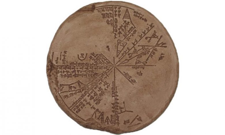
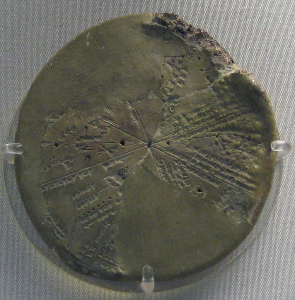
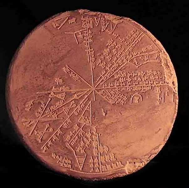
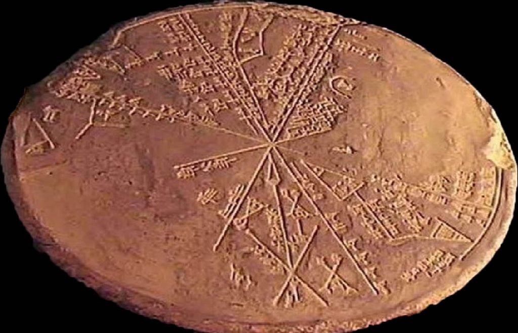
This 5,500-Year-Old Sumerian Star Map Recorded the Impact of a Massive Asteroid
An ancient Sumerian astronomer recorded on the clay tablet the events he observed on 29 June 3123 BC.
An ancient clay tablet housed at the British Museum has puzzled experts for more than 150 years. The Cuneiform tablet in the British Museum collection No K8538 is known as “the Planisphere.” Translated more than ten years ago, the clay tablet is an ancient Sumerian Star Map.
Researchers claim it describes an asteroid impact in ancient times. The clay tablet was recovered in the 19th century from the underground library of King Ashurbanipal in Nineveh, Iraq, by Sir. Henry Layard.
Translations and eventual analysis revealed stunning details. The ancient Sumerians etched on the surface of the clay tablet details revealing they observed a massive object, visible in space, as it smashed through Earth’s atmosphere and eventually impacted the planet.
The tablet is a copy of notes inscribed by an ancient Sumerian astronomer that observed the sky. He referred to the object coming from the sky as a “white stone bowl approaching…”
Part of a circular clay tablet with depictions of constellations (planisphere); the reverse is uninscribed; restored from fragments and incomplete; partly accidentally vitrified in antiquity during the destruction of the place where it was found. Found in Kuyunjik, ancient Nineveh, in the so-called “Library of Ashurbanipal.” Neo-Assyrian period.
The tablet is an astronomical work since it features intricate drawings of constellations and their names. Since its discovery, experts have been unable to fully understand what the Sumerian Astronomer wanted to convey. That changed with the appearance of computer programs that could help simulate trajectories and reconstruct the night sky thousands of years ago. And it is precisely that way that experts finally understood what the Planisphere tablet refers to.
An ancient Sumerian astronomer recorded the events he observed on 29 June 3123 BC.
Experts found that fifty percent of the clay tablet refers to the position of the planets and weather conditions, like cloud cover. However, the other half of the tablet details how a massive object, large enough to be observed even though it was still in space, was seen approaching Earth.
The Sumerian astronomer decided the event was of great importance, so he accurately noted the object’s trajectory relative to the stars. And it turns out that the object observed by the Sumerian astronomer was most likely the asteroid that impacted Köfels, Austria.
According to experts, the astronomer accurately noted the object’s trajectory to an error of better than one degree.
Based on the observations made by the Sumerian astronomers, scientists have concluded that the object in question was most likely an asteroid over one kilometer in diameter. It was most likely an Aten-type asteroid that orbited relatively close to the planet given its orbit.
The data etched on the clay tablet explains why there isn’t an actual impact crater at Köfels. Observations indicate that the asteroid’s incoming angle was as low as six degrees. This suggests the space rock most likely clipped a mountain on its way down (most likely the tip of Gamskogel), causing the asteroid to disintegrate before reaching its final impact point.
Scientists explain that as it made its way down the valley, the asteroid turned into a gigantic fireball, around five kilometers in diameter. As it impacted Köfels, it produced extremely high pressures that caused the rock to pulverize.
However, since it was no longer a solid object, it did not leave an impact crater behind.
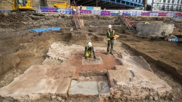
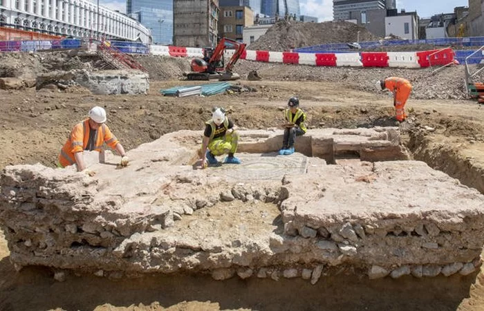
‘Incredibly Rare’ Roman Mausoleum Unearthed Near London Bridge Station
Archaeologists report discovering an “incredibly rare” and featured preserved floors and walls Roman mausoleum near London Bridge Station, UK.
Archaeologists discovered big Roman mosaics at the same location last year, which led scientists to believe something much larger might be buried beneath the surface.
Excavations conducted by MOLA archaeologists on behalf of Landsec, Transport for London (TfL), which owns the site, and Southwark Council have yielded extraordinary results.
Archaeologists say they have unearthed the remains of a Roman mausoleum “with an astonishing level of preservation.”
The Museum of London Archaeology(MOLA) believes the quality of preservation makes it the most intact Roman mausoleum ever to be discovered in Britain.
Scientists have “unearthed the walls, entrance steps and interior floors of the tomb. The mosaic at the center is surrounded by a raised platform on which the burials were placed.
There’s evidence of a second mosaic directly beneath the first, indicating that it was raised during its lifetime. The two mosaics are similar, with a central flower surrounded by concentric circles.
The tomb itself was a two-storey building likely to have been used by a wealthy Roman family. It doesn’t now contain any coffins or burial remains, with MOLA suggesting that these were likely removed in medieval times.
However, the surrounding area is rich in traces of its ancient inhabitants, with over 80 burial sites and artifacts such as pottery, jewelry, coins, and glass beads.
Antonietta Lerz, senior archaeologist at MOLA, says the site is a “microcosm for the changing fortunes of Roman London” and provides “a fascinating window” into the life of its settlers.
Antonietta Lerz, senior archaeologist at MOLA, says the site is a “microcosm for the changing fortunes of Roman London” and provides “a fascinating window” into the life of its settlers.
Archaeologists from MOLA hope to pinpoint the age of the mausoleum and have provided a three-dimensional model of the site. There are plans for the future public display of the mausoleum.
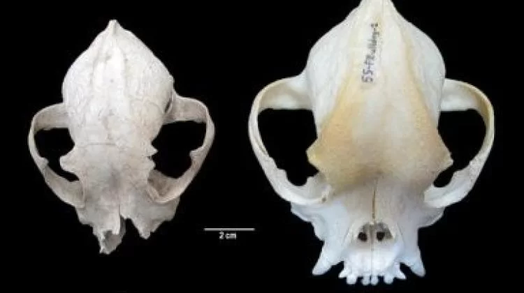
New research, proves that Romans were breeding small bulldogs
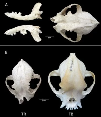
Researchers have proven that breeding small brachycephalic (shorter-nosed) dogs took place already in ancient Rome. Research on a 2,000 years old dog skull indicates that the dog resembled a French bulldog.
Analyzing the remains of a canine skull at a Roman-era site in Türkiye, researchers have determined that the ancient pooch had a brachycephalic skull similar to that of a French Bulldog.
In 2007, dog bones were found in the ruins of the ancient Tralleis, near the Turkish city of Aydın. The find was incomplete, and due to the poor condition of the remains no one paid much attention to it for many years.
In 2021, the bones caught the attention of Professor Aleksander Chrószcz and Dr. Dominik Poradowski from the Wrocław University of Environmental and Life Sciences and a team of researchers from Istanbul University led by Professor Vedat Onar.
‘Fortunately, the skull was not so damaged or fragmented to prevent its measurements, and this research is an important part of our investigation because taking measurements allows us to compare it with other results of archaeozoological research, and with bone material from modern animals.
We conducted craniometry, or in the simplest terms, we determined measurement points on the bones of the skull and based on these points, we not only managed to determine the value of individual measurements but also compare them with contemporary, testable dog skull craniometry results’, says Professor Aleksander Chrószcz.
Photo: Wrocław University of Environmental and Life Sciences
He adds that due to the state of preservation of the remains (measuring the length of the skull was not possible), the researchers relied on other measurements, including the area of the base of the skull, the tympanic cavity, the teeth, and the palate.
‘In this case, there was no doubt that it was the skull of a brachycephalic (short-nosed) dog, and a relatively small one.
The analysis of the preserved and measurable parts of the animal’s skeleton and the skeletons of dogs of modern breeds shows that it was most likely an animal that was lower at the withers than the well-known, also short-nosed Molossian hounds, whose pedigree originating from ancient Hellas is beyond doubt’, says Professor Aleksander Chrószcz.
He emphasizes that in order to make sure that scientists were dealing with such an ancient find, a radiocarbon dating procedure was carried out at a reputable, reference laboratory in the United States.
Photo: Wrocław University of Environmental and Life Sciences
‘The discovery of the remains of a dog with this anatomy brings us valuable information. Scientists have been able to prove that in Ancient Rome, Molossian hounds were not the only known brachycephalic dogs.
It would not be new information if not for the fact that this animal was much smaller, and its morphology more similar to that of a French bulldog, a modern companion dog.
It was supposed to accompany its guardian, sharing a fairly comfortable life, instead of being a working dog often mentioned in the available Roman literature, we read in the Wrocław University of Environmental and Life Sciences press release.
According to the release, the animal was probably cared for not only during its life but also after death.
Skeletal examinations showed that the quadruped was treated exceptionally well, which distinguishes it from other discovered remains of working dogs.
Photo: Wrocław University of Environmental and Life Sciences
‘Someone must have loved this dog, because most they likely they ordered to be buried with it. This means that the love between humans and animals is not a modern invention’, concludes the scientist from the Wrocław University of Environmental and Life Sciences.
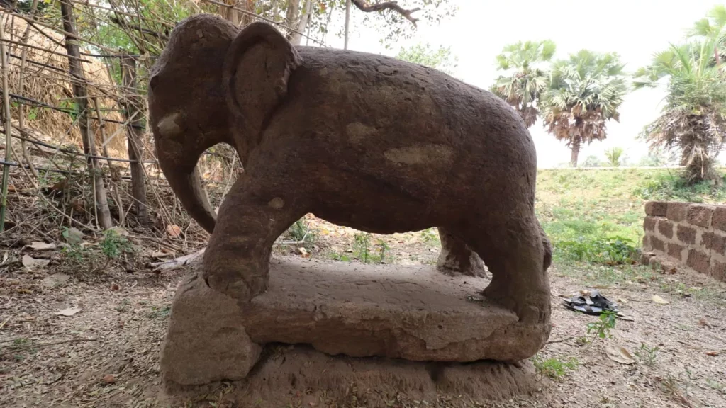
A 2,300-Year-Old Elephant Sculpture Discovered in India
Elephants commonly appear in Buddhist art from the period and archaeologists think it is a relic of early Buddhist worship in the region.
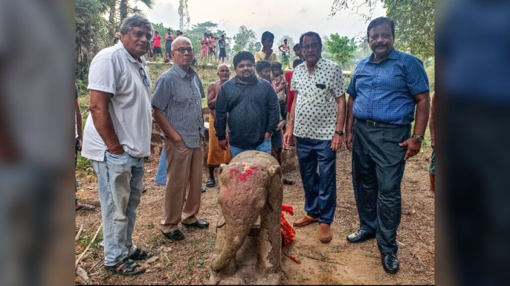
Archaeologists in eastern India have unearthed a statue of an elephant they think was carved about 2,300 years ago when Buddhism was the main religion in the region.
The statue is about 3 feet (1 meter) high and carved from rock in the same style as other Buddhist statues of elephants found across the state of Odisha.
Historian Anil Dhir and other members of an archaeological team from the Indian National Trust for Art and Cultural Heritage (INTACH) unearthed the statue in April at a village on the banks of the Daya River in Odisha’s Puri District. “We were surveying the Daya River Valley to document its heritage,” Dhir told Live Science in an email. “This area is rich in artifacts from the ancient Buddhism which flourished here.”
The elephant statue is carved from rock in the style of statues found at other sites nearby from about 2,300 years ago when the region was strongly Buddhist.
The team found several other buried archaeological relics around the village, including architectural pieces from a Buddhist temple, he added.
The elephant statue is very similar to one found at Dhauli, also known as Dhaulagiri, an ancient center of Buddhism about 12 miles (19 kilometers) upstream, Dhir said. That statue has been dated to between 272 B.C. and 231 B.C.
Buddha and Hinduism
A team of archaeologists and historians from the Indian National Trust for Art and Cultural Heritage (INTACH) discovered the statue in April.
Buddhism originated in northern India in the sixth or fifth century B.C. and was one of the main religions under Emperor Ashoka of the Maurya Empire in the second century B.C., the historian Upinder Singh of Ashoka University in India wrote in “History of Ancient and Early Medieval India: From the Stone Age to the 12th Century” (Pearson India, 2009). The empire covered most of India, including what’s now Pakistan, but not the very south of the subcontinent.
And from the third century B.C. until about the second century A.D., Buddhism “held sway” throughout much of India and the Odisha region in particular, Dhir said.
But Buddhism’s influence declined as its practices became assimilated into the myriad traditions of Hinduism and when Islam became more influential in the region after the 10th century; and while Buddhism is now widespread in other parts of Asia, it is only followed by about 0.7% of the modern population of India, according to a 2011 census. (The Buddha is worshipped, however, in some Hindu ceremonies, sometimes as an avatar of the god Vishnu.)
According to a statement by INTACH, the floodplains of the Daya and Mandakini rivers are rich in Buddhist antiquities.
Records also suggest that a fort was built at the site in the 16th century, and the INTACH team has found remnants of its defensive walls and moat.
Elephant symbolism
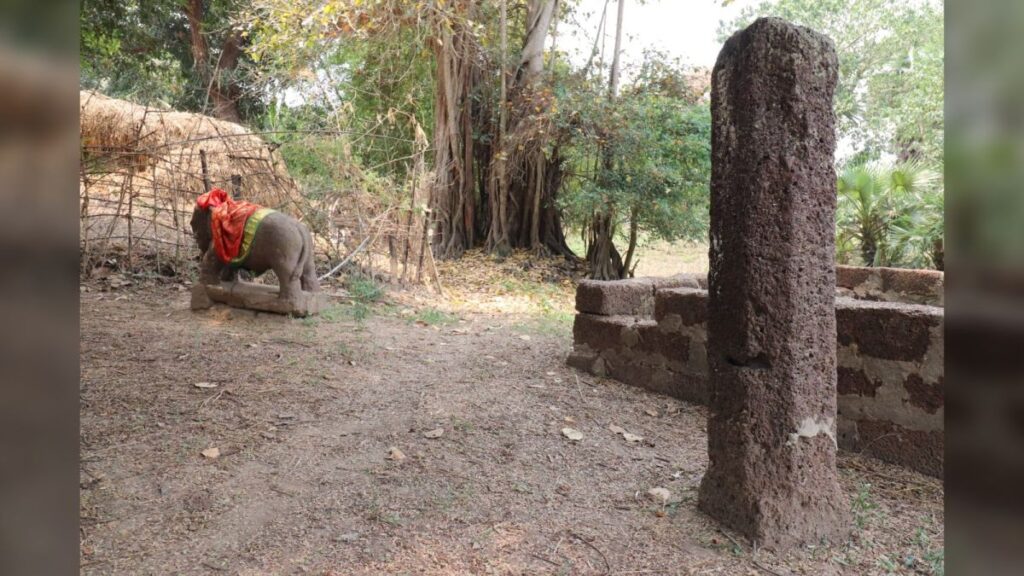
The archaeologists also found a carved laterite pillar nearby, which is an arrangement seen at other early Buddhist archaeological sites in the region.
Dhir said the elephant was a common motif in Buddhism and could be seen in many Buddhist monuments.
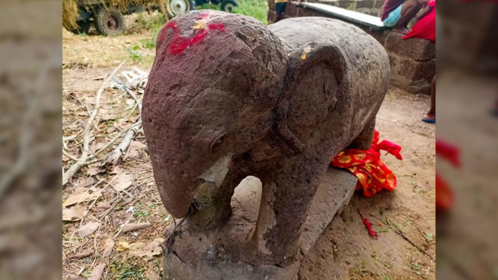
The INTACH statement said the recently unearthed elephant statue was found near a pillar of laterite — a reddish clay material — and other stone blocks: Similar finds were also discovered alongside another elephant statue found in the village of Kaima in Odisha’s Jajpur District.
Art historian Christian Luczanits of SOAS at the University of London told Live Science that elephants were important royal animals in ancient India and symbolized the monsoon rains and fertility.
Peter Harvey, a historian of Buddhism and a “faith advisor” at York St John University in the U.K., added that the elephant was also the mythical animal ridden by the pre-Buddhist god Indra, who was identified in early Indian Buddhism as a disciple of the Buddha and named Sakka (also spelled Śakra).
The elephant’s direct connection to Buddhism came about from a story that the mother of Siddhartha Gautama — the Indian prince who would become the Buddha — dreamt after he was conceived that “an auspicious white elephant [had] entered her womb,” Harvey said.
Indonesia discovers 700,000-year-old ‘hobbit’ fossils
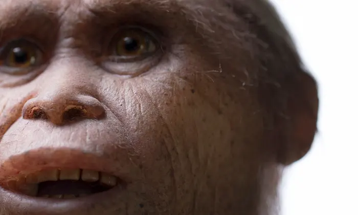
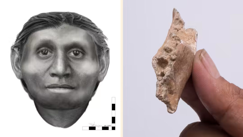
A visual approximation of the hobbit by Dr Susan Hayes, and right, a section of jawbone found at Mata Menge in Indonesia.
Dwarf “hobbits” lived on the Indonesian island of Flores for hundreds of thousands of years, according to evidence from newly excavated hominin fossils. An international research team, following up on the original hobbit discovery that drew international attention in 2004, has discovered a fossilized diminutive jaw bone and six small teeth from an adult and two children that they believe are 700,000 years old.
The scientists believe that the new finds, described in the journal Nature, represent ancestors of the hominin species Homo floresiensis, whose remains were discovered in 2004 and date back to around 55,000 years ago.
“The fossils . . . appear to be remarkably similar to those of Homo floresiensis,” said Yousuke Kaifu of Tokyo’s National Museum of Nature and Science, who led their dating and identification. “What is truly unexpected is that . . . Homo floresiensis had already obtained its small size by at least 700,000 years ago.”
The original discovery led to a debate between paleontologists who proposed that the fossils represented nothing more than a modern human with pathological dwarfism and those who favored a previously unknown hominin species.
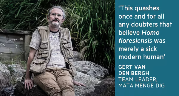
“This find has important implications for our understanding of early human dispersal and evolution in the region — and quashes once and for all any doubters that believe Homo floresiensis was merely a sick modern human (Homo sapiens),” said Gert van den Bergh from Wollongong university in Australia, who led the archaeological team that excavated the jaw fragment and teeth from layers of sedimentary rock at Mata Menge on Flores.
Aida Gómez-Robles, a paleontologist at George Washington University in the US who was not part of the Flores team, agreed: “The current findings . . . confirm beyond any reasonable doubt that Homo floresiensis is a distinct hominin species with deep evolutionary roots.”
The discovery site is 70km from the Liang Bua cave where the original hobbit remains were found. The team chose to dig into the fossil-rich sandstone at Mata Menge because hundreds of thousands of years ago it was the site of a stream running through open grassland with some trees — the sort of place ancient hominins liked to live. Simple stone tools had already been found nearby.
The big evolutionary questions are when the hobbit ancestors originally reached Flores and why they became so much smaller than any other known hominins.
The oldest signs of human habitation on the island are stone tools from about 1m years ago, believed to have been left by Homo erectus, a hominin species then moving through southeast Asia by land.
Mr van den Bergh believes some individuals reached Flores accidentally — perhaps swept out to sea by a tsunami and drifting on debris — because there is no archaeological evidence for boatbuilding so long ago.
Isolated island populations of other animals are often subject to evolutionary dwarfing. Flores itself was home to two now-extinct species of pygmy elephants. If the founding population was indeed Homo erectus, then its stature would have decreased by about one-third (to around one meter tall) and its brain size shrunk by half within 300,000 years.
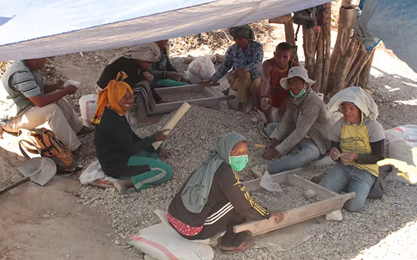
Workers at the archaeological dig at Mata Menge, Flores Island, sift for bone fragments.
An alternative explanation is that a smaller and older species of hominin such as Homo habilis reached Flores more than 1m years ago and underwent a slower dwarfing process.
The researchers say this is less likely because there is no evidence for the presence of hominins in what is now Indonesia so long ago.
The mystery can only be solved by the discovery of more complete skeletal remains of ancestral hobbits — including limbs and skulls — on Flores through more intensive excavation work.
An archaeologist says he’s discovered the world’s oldest pyramids 7,400 Years older than Egyptian pyramids
Sam Osmanagich claims that 12,000 years ago, early Europeans built “the greatest pyramidal complex” on earth, in Bosnia.
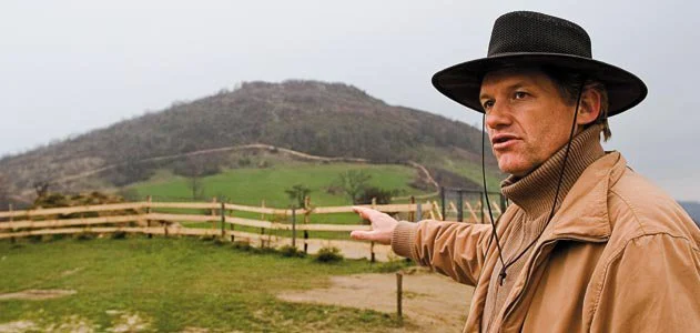
Sam Osmanagich kneels down next to a low wall, part of a 6-by-10-foot rectangle of fieldstone with an earthen floor. If I’d come upon it in a farmer’s backyard here on the edge of Visoko—in Bosnia and Herzegovina, 15 miles northwest of Sarajevo—I would have assumed it to be the foundation of a shed or cottage abandoned by some 19th-century peasant. Osmanagich, a blond, 49-year-old Bosnian who has lived for 16 years in Houston, Texas, has a more colorful explanation. “Maybe it’s a burial site, and maybe it’s an entrance, but I think it’s some type of ornament, because this is where the western and northern sides meet,” he says, gesturing toward the summit of Pljesevica Hill, 350 feet above us. “You find evidence of the stone structure everywhere. Consequently, you can conclude that the whole thing is a pyramid.”
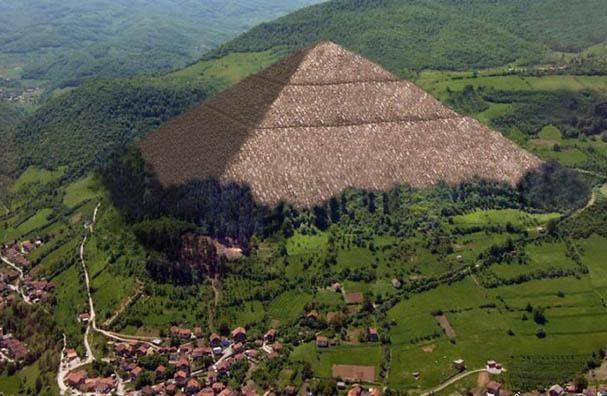
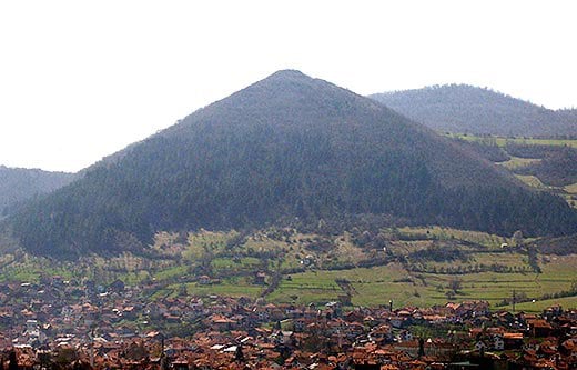
Visocica Hill, a.k.a. the “Pyramid of the Sun,” overlooks Visoko, a bastion of support for Bosnian Muslim nationalists.
Not just any pyramid, but what Osmanagich calls the Pyramid of the Moon, the world’s largest—and oldest—step pyramid. Looming above the opposite side of town is the so-called Pyramid of the Sun—also known as Visocica Hill—which, at 720 feet, also dwarfs the Great Pyramids of Egypt. A third pyramid, he says, is in the nearby hills. All of them, he says, are some 12,000 years old. During that time much of Europe was under a mile-thick sheet of ice and most of humanity had yet to invent agriculture. As a group, Osmanagich says, these structures are part of “the greatest pyramidal complex ever built on the face of the earth.”
In a country still recovering from the 1992-95 genocidal war, in which some 100,000 people were killed and 2.2 million were driven from their homes (the majority of them Bosnian Muslims), Osmanagich’s claims have found a surprisingly receptive audience. Even Bosnian officials—including a prime minister and two presidents—have embraced them, along with the Sarajevo-based news media and hundreds of thousands of ordinary Bosnians, drawn to the promise of a glorious past and a more prosperous future for their battered country. Skeptics, who say the pyramid claims are examples of pseudo-archaeology pressed into the service of nationalism, have been shouted down and called anti-Bosnian. Pyramid mania has descended upon Bosnia. Over 400,000 people have visited the sites since October 2005, when Osmanagich announced his discovery. Souvenir stands peddle pyramid-themed T-shirts, wood carvings, piggy banks, clocks and flip-flops. Nearby eateries serve meals on pyramid-shaped plates and coffee comes with pyramid-emblazoned sugar packets. Foreigners by the thousands have come to see what all the fuss is about, drawn by reports by the BBC, Associated Press, Agence France-Presse and ABC’s Nightline (which reported that thermal imaging had “apparently” revealed the presence of man-made, concrete blocks beneath the valley).
Osmanagich has also received official backing. His Pyramid of the Sun Foundation in Sarajevo has garnered hundreds of thousands of dollars in public donations and thousands more from state-owned companies. After Malaysia’s former prime minister, Mahathir Mohamad, toured Visoko in July 2006, more contributions poured in. Christian Schwarz-Schilling, the former high representative for the international community in Bosnia and Herzegovina, visited the site in July 2007, then declared that “I was surprised with what I saw before my eyes, and the fact that such structures exist in Bosnia and Herzegovina.”
The town of Visoko was shelled during the civil war and is also the site of the ruins of a medieval fortress.
Osmanagich’s many appearances on television have made him a national celebrity. In Sarajevo, people gape at him on the streets and seek his autograph in cafés. When I was with him one day at the entrance to city hall, guards jumped out of their booths to embrace him. Five years ago, almost no one had ever heard of him. Born in Zenica, about 20 miles north of Visoko, he earned a master’s degree in international economics and politics at the University of Sarajevo. (Years later, he obtained a doctorate in the sociology of history. ) He left Bosnia before its civil war, emigrating to Houston in 1993 (because, in part, of its warm climate), where he started a successful metalworking business that he still owns today. While in Texas he got interested in the Aztec, Incan and Maya civilizations and made frequent trips to visit pyramid sites in Central and South America. He says that he’s visited hundreds of pyramids worldwide.
His views of world history—described in his books published in Bosnia—are unconventional. In The World of the Maya, which was reprinted in English in the United States, he writes that “Mayan hieroglyphics tell us that their ancestors came from the Pleiades….first arriving at Atlantis where they created an advanced civilization.” He speculates that when a 26,000-year cycle of the Maya calendar is completed in 2012, humankind might be raised to a higher level by vibrations that will “overcome the age of darkness which has been oppressing us.” In another work, Alternative History, he argues that Adolf Hitler and other Nazi leaders escaped to a secret underground base in Antarctica from which they did battle with Adm. Richard Byrd’s 1946 Antarctic expedition.
“His books are filled with these kinds of stories,” says journalist Vuk Bacanovic, one of Osmanagich’s few identifiable critics in the Sarajevo press corps. “It’s like a religion based on corrupted New Age ideology.”
In April 2005, while in Bosnia to promote his books, Osmanagich accepted an invitation to visit a local museum and the summit of Visocica, which is topped by the ruins of Visoki, a seat of Bosnia’s medieval kings. “What really caught my eye was that the hill had the shape of a pyramid,” he recalls. “Then I looked across the valley and I saw what we today call the Bosnian Pyramid of the Moon, with three triangular sides and a flat top.” Upon consulting a compass, he concluded the sides of the pyramid were perfectly oriented toward the cardinal points (north, south, east and west). He was convinced this was not “the work of Mother Nature.”
After his mountaintop epiphany, Osmanagich secured digging permits from the appropriate authorities, drilled some core samples and wrote a new book, The Bosnian Pyramid of the Sun, which announced “to the world that in the heart of Bosnia” is a hidden “stepped pyramid whose creators were ancient Europeans.” He then set up a nonprofit foundation called the Archaeological Park: Bosnian Pyramid of the Sun Foundation, which allowed him to seek funding for his planned excavation and preservation work.
“When I first read about the pyramids I thought it was a very funny joke,” says Amar Karapus, a curator at the National Museum of Bosnia and Herzegovina in Sarajevo. “I just couldn’t believe that anyone in the world could believe this.”
Visoko lies near the southern end of a valley that runs from Sarajevo to Zenica. The valley has been quarried for centuries and its geological history is well understood. It was formed some ten million years ago as the mountains of Central Bosnia were pushing skyward and was soon flooded, forming a lake 40 miles long. As the mountains continued to rise over the next few million years, sediments washed into the lake and settled on the bottom in layers. If you dig in the valley today, you can expect to find alternating layers of various thickness, from gossamer-thin clay sediments (deposited in quiet times) to plates of sandstones or thick layers of conglomerates (sedimentary rocks deposited when raging rivers dumped heavy debris into the lake). Subsequent tectonic activity buckled sections of lakebed, creating angular hills, and shattered rock layers, leaving fractured plates of sandstone and chunky blocks of conglomerate. In early 2006 Osmanagich asked a team of geologists from the nearby University of Tuzla to analyze core samples at Visocica. They found that his pyramid was composed of the same matter as other mountains in the area: alternating layers of conglomerate, clay and sandstone.
Nonetheless, Osmanagich put scores of laborers to work digging on the hills. It was just as the geologists had predicted: the excavations revealed layers of fractured conglomerate at Visocica, while those at Pljesevica uncovered cracked sandstone plates separated by layers of silt and clay. “What he’s found isn’t even unusual or spectacular from the geological point of view,” says geologist Robert Schoch of Boston University, who spent ten days at Visoko that summer. “It’s completely straightforward and mundane.”
“The landform [Osmanagich] is calling a pyramid is actually quite common,” agrees Paul Heinrich, an archaeological geologist at Louisiana State University. “They’re called ‘flatirons’ in the United States and you see a lot of them out West.” He adds that there are “hundreds around the world,” including the “Russian Twin Pyramids” in Vladivostok.
Apparently unperturbed by the University of Tuzla report, Osmanagich said Visocica’s conglomerate blocks were made of concrete that ancient builders had poured on-site. This theory was endorsed by Joseph Davidovits, a French materials scientist who, in 1982, advanced another controversial hypothesis—that the blocks making up the Egyptian pyramids were not carved, as nearly all experts believe, but cast in limestone concrete. Osmanagich dubbed Pljesevica’s sandstone plates “paved terraces,” and according to Schoch, workers carved the hillside between the layers—to create the impression of stepped sides on the Pyramid of the Moon. Particularly uniform blocks and tile sections were exposed for viewing by dignitaries, journalists and the many tourists who descended on the town.
Osmanagich’s announcements sparked a media sensation, stoked with a steady supply of fresh observations: a 12,000-year-old “burial mound” (without any skeletons) in a nearby village; a stone on Visocica with alleged curative powers; a third pyramid dubbed the Pyramid of the Dragon; and two “shaped hills” that he has named the Pyramid of Love and the Temple of Earth. And Osmanagich has recruited an assortment of experts whom he says vindicate his claims. For instance, in 2007, Enver Buza, a surveyor from Sarajevo’s Geodetic Institute, published a paper stating that the Pyramid of the Sun is “oriented to the north with a perfect precision.”
Many Bosnians have embraced Osmanagich’s theories, particularly those from among the country’s ethnic Bosniaks (or Bosnian Muslims), who constitute about 48 percent of Bosnia’s population. Visoko was held by Bosniak-led forces during the 1990s war, when it was choked with refugees driven out of surrounding villages by Bosnian Serb (and later, Croat) forces, who repeatedly shelled the town. Today it is a bastion of support for the Bosniaks’ nationalist party, which controls the mayor’s office. A central tenet of Bosniak national mythology is that Bosniaks are descended from Bosnia’s medieval nobility. Ruins of the 14th-century Visoki Castle can be found on the summit of Visocica Hill—on top of the Pyramid of the Sun—and, in combination, the two icons create considerable symbolic resonance for Bosniaks. The belief that Visoko was a cradle of European civilization and that the Bosniaks’ ancestors were master builders who surpassed even the ancient Egyptians has become a matter of ethnic pride. “The pyramids have been turned into a place of Bosniak identification,” says historian Dubravko Lovrenovic of the Bosnia and Herzegovina Commission to Preserve National Monuments. “If you are not for the pyramids, you are accused of being an enemy of the Bosniaks.”
For his part, Osmanagich insists he disapproves of those who exploit his archaeological work for political gain. “Those pyramids don’t belong to any particular nationality,” he says. “These are not Bosniak or Muslim or Serb or Croat pyramids, because they were built at a time when those nations and religions were not in existence.” He says his project should “unite people, not divide them.”
Yet Bosnia and Herzegovina still bears the deep scars of a war in which the country’s Serbs and, later, Croats sought to create ethnically pure small states by killing or expelling people of other ethnicities. The most brutal incident occurred in 1995, when Serb forces seized control of the town of Srebrenica—a United Nations-protected “safe haven”—and executed some 8,000 Bosniak men of military age. It was the worst civilian massacre in Europe since World War II.
Wellesley College anthropologist Philip Kohl, who has studied the political uses of archaeology, says that Osmanagich’s pyramids exemplify a narrative common to the former Eastern bloc. “When the Iron Curtain collapsed, all these land and territorial claims came up, and people had just lost their ideological moorings,” he notes. “There’s a great attraction in being able to say, ‘We have great ancestors, we go back millennia and we can claim these special places for ourselves.’ In some places it’s relatively benign; in others it can be malignant.”
“I think the pyramids are symptomatic of a traumatized society that is still trying to recover from a truly horrendous experience,” says Andras Riedlmayer, a Balkan specialist at Harvard University. “You have many people desperate for self-affirmation and in need of money.”
Archaeological claims have long been used to serve political purposes. In 1912, British archaeologists combined a modern skull with an orangutan jaw to fabricate a “missing link” in support of the claim that human beings arose in Britain, not Africa. (The paleontologist Richard Leakey later noted that English elites took so much pride in “being the first, that they swallowed [the hoax] hook, line and sinker.” )
More recently, in 2000, Shinichi Fujimura—a prominent archaeologist whose finds suggested that Japanese civilization was 700,000 years old—was revealed to have buried the forged artifacts he had supposedly discovered. “Fujimura’s straightforward con was undoubtedly accepted by the establishment, as well as the popular press, because it gave them evidence of what they already wanted to believe—the great antiquity of the Japanese people,” Michele Miller wrote in the archaeological journal Athena Review.
Some Bosnian scholars have publicly opposed Osmanagich’s project. In April 2006, twenty-one historians, geologists and archaeologists signed a letter published in several Bosnian newspapers describing the excavations as amateurish and lacking proper scientific supervision. Some went on local television to debate Osmanagich. Bosniak nationalists retaliated, denouncing pyramid opponents as “corrupt” and harassing them with e-mails. Zilka Kujundzic-Vejzagic of the National Museum, one of the Balkans’ pre-eminent archaeologists, says she received threatening phone calls. “One time I was getting onto the tram and a man pushed me off and said, ‘You’re an enemy of Bosnia, you don’t ride on this tram,'” she recalls. “I felt a bit endangered.”
“I have colleagues who have gone into silence because the attacks are constant and very terrible,” says University of Sarajevo historian Salmedin Mesihovic. “Every day you feel the pressure.”
“Anyone who puts their head above the parapet suffers the same fate,” says Anthony Harding, a pyramid skeptic who was, until recently, president of the European Association of Archaeologists. Sitting in his office at the University of Exeter in England, he reads from a thick folder of letters denouncing him as a fool and a friend of the Serbs. He labeled the file “Bosnia—Abuse.”
In June 2006, Sulejman Tihic, then chairman of Bosnia’s three-member presidency, endorsed the foundation’s work. “One does not need to be a big expert to see that those are the remains of three pyramids,” he told journalists at a summit of Balkan presidents. Tihic invited Koichiro Matsuura, then director-general of Unesco, to send experts to determine if the pyramids qualified as a World Heritage site. Foreign scholars, including Harding, rallied to block the move: 25 of them, representing six countries, signed an open letter to Matsuura warning that “Osmanagich is conducting a pseudo-archaeological project that, disgracefully, threatens to destroy parts of Bosnia’s real heritage.”
But the Pyramid Foundation’s political clout appears considerable. When the minister of culture of the Bosniak-Croat Federation, Gavrilo Grahovac, blocked the renewal of foundation permits in 2007—on the grounds that the credibility of those working on the project was “unreliable”—the action was overruled by Nedzad Brankovic, then the federation prime minister. “Why should we disown something that the entire world is interested in?” Brankovic told reporters at a press conference following a visit to the site. “The government will not act negatively toward this project.” Haris Silajdzic, another member of the national presidency, has also expressed support for Osmanagich’s project, on grounds that it helps the economy.
Critics contend that the project not only sullies Bosnian science but also soaks up scarce resources. Osmanagich says his foundation has received over $1 million, including $220,000 from Malaysian tycoon Vincent Tan; $240,000 from the town of Visoko; $40,000 from the federal government; and $350,000 out of Osmanagich’s pocket. Meanwhile, the National Museum in Sarajevo has struggled to find sufficient funds to repair wartime damage and safeguard its collection, which includes more than two million archaeological artifacts and hundreds of thousands of books.
Critics also cite the potential damage to Bosnia’s archae- ological heritage. “In Bosnia, you can’t dig in your back garden without finding artifacts,” says Adnan Kaljanac, a graduate student of ancient history at the University of Sarajevo. Although Osmanagich’s excavation has kept its distance from the medieval ruins on Visocica Hill, Kaljanac worries that the project may destroy undocumented Neolithic, Roman or medieval sites in the valley. Similarly, in a 2006 letter to Science magazine, Schoch said the hills in Visoko “could well yield scientifically valuable terrestrial vertebrate specimens. Presently, the fossils are being ignored and destroyed during the ‘excavations,’ as crews work to shape the natural hills into crude semblances of the Mayan-style step pyramids with which Osmanagich is so enamored.”
That same year, the Commission to Preserve National Monuments, an independent body created in 1995 by the Dayton peace treaty to safeguard historical artifacts from nationalist infighting, asked to inspect artifacts reportedly found at Osmanagich’s site. According to commission head Lovrenovic, commission members were refused access. The commission then expanded the protected zone around Visoki, effectively pushing Osmanagich off the mountain. Bosnia’s president, ministers and parliament currently have no authority to override the commission’s decisions. But if Osmanagich has begun to encounter obstacles in his homeland, he’s had continuing success abroad. This past June, he was made a foreign member of the Russian Academy of Natural Sciences, one of whose academicians served as “scientific chairman” of the First International Scientific Conference of the Valley of the Pyramids, which Osmanagich convened in Sarajevo in August 2008. Conference organizers included the Russian Academy of Technical Sciences, Ain Shams University in Cairo and the Archaeological Society of Alexandria. This past July, officials in the village of Boljevac, Serbia, claimed that a team sent by Osmanagich had confirmed a pyramid under Rtanj, a local mountain. Osmanagich e-mailed me he had not visited Rtanj himself nor had he initiated any research at the site. However, he told the Serbian newspaper Danas that he endorsed future study. “This is not the only location in Serbia, nor the region, where there is a possibility of pyramidal structures,” he was quoted as saying.
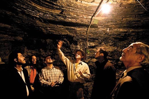
For now Osmanagich has gone underground, literally, to excavate a series of what he says are ancient tunnels in Visoko—which he believes are part of a network that connects the three pyramids. He leads me through one of them, a cramped, three-foot-high passage through disconcertedly unconsolidated sand and pebbles he says he is widening into a seven-foot-tall thoroughfare—the tunnel’s original height, he maintains—for tourists. (The tunnel was partially filled, he says, when sea levels rose by 1,500 feet at the end of the ice age.) He points out various boulders he says were transported to the site 15,000 years ago, some of which bear carvings he says date back to that time. In an interview with the Bosnian weekly magazine BH Dani, Nadija Nukic, a geologist whom Osmanagich once employed, claimed there was no writing on the boulders when she first saw them. Later, she saw what appeared to her as freshly cut marks. She added that one of the foundation’s workers told her he had carved the first letters of his and his children’s names. (After the interview was published, Osmanagich posted a denial from the worker on his Web site. Efforts to reach Nukic have been unavailing.)
Osmanagich’s tour of his discoveries includes the terraced sides of the “Pyramid of the Moon” and a tunnel that he believes is part of a network that connects three pyramids.
Some 200 yards in, we reach the end of the excavated portion of the tunnel. Ahead lies a tenuous-looking crawl space through the gravelly, unconsolidated earth. Osmanagich says he plans to dig all the way to Visocica Hill, 1.4 miles away, adding that, with additional donations, he could reach it in as few as three years. “Ten years from now nobody will remember my critics,” he says as we start back toward the light, “and a million people will come to see what we have.