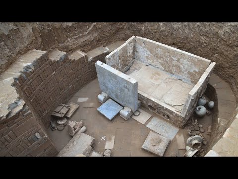
China Daily reports that a tomb dated to the Sui Dynasty (A.D. 581–618) has been unearthed in central China’s Henan Province.
The tomb, which contains a coffin bed and screen made of white marble carved with patterns resembling those found in Zoroastrianism and Buddhism, belonged to a previously unknown couple named Qu Qing.
An epigraph unearthed from the tomb records the life experience of the tomb owners, a couple with the name Qu Qing, who never appeared in any historical files before.
This is a copy of an epigraph that was unearthed from a Sui Dynasty (581-618) tomb in Anyang, Central China’s Henan province.
The epigraph provides new evidence for character evolution and the art of calligraphy during the Sui Dynasty, according to the Anyang Institute of Cultural Relics and Archaeology, adding that it also has great value as complementing the institute’s history section.
Various patterns strongly in the style of Zoroastrianism were carved on the coffin bed and the screen, showing the daily life of the tomb owners and some religious allusions.
“The Qu family lived in the Longxi area, which occupied the main part of the Silk Road for a long time, so they were deeply influenced by European, West Asian and Central Asian cultures,” said Kong Deming, head of the institute.
The discovery of the coffin bed and dozens of relief patterns carved in Buddhist and Zoroastrian styles can be seen as a witness to the exchanges and mutual learning between Eastern and Western civilizations along the Silk Road, Kong said.
Furthermore, a large number of exquisite white Xiangzhou kiln porcelain was unearthed at the site.
Several porcelain tomb figures were unearthed from a Sui Dynasty (581-618) tomb in Anyang, Central China’s Henan province
These two tomb figures were unearthed from a Sui Dynasty (581-618) tomb in Anyang, Central China’s Henan province.
According to Kong, the porcelain shows the high production level of the Xiangzhou kiln in Anyang during the Sui Dynasty.
It can also fill in the blanks in the research on Xiangzhou kiln porcelains and provide valuable materials for the origin and development of Chinese white porcelain.
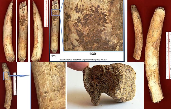
Prehistoric people developed a technique for making a play dough-like material from mammoth ivory
It is stated in The Siberian Times that Evgeny Artemyev of the Russian Academy of Sciences has studied 12,000-year-old archaeological objects that have been found some 20 years ago at the Afontova Gora-2 archaeological site, which is situated on the banks of the Yenisei River in south-central Siberia.
The items include objects made from the spongey parts of woolly mammoth bones.
The finds were made in early 2000 but were re-examined recently by Dr Evgeny Artemyev who said that the figurines can be either Ice Age toys made by people who populated this area of the modern-day Siberia, or a form of primaeval art.
‘When you look at them at different angles, they resemble different types of animals.
‘It is possible that this is the new form of Palaeolithic art, that the international scientific community is not aware of yet’, the archaeologist said.
These animal-like figurines were made from spongy parts of woolly mammoth bones, and could have been either toys, or some form of premieval art.
The two prehistoric figurines appear similar to a bear and a mammoth, says Dr Artemyev, who has worked at the site since the 1990s.
Looked at from another angle, one of the figurines maybe a sleeping human.
The ivory bars, some of them phallic-shaped, discovered at the same site were created with a technique which made them almost ‘fluid-like’.
‘The mammoth tusk was softened to the extent that it resembled modern-day playdough. We don’t know yet how ancient people achieved that’, Dr Artemyev said.
‘On the items, we can see traces of stone implements and the flows of the substance before it stiffened. This means that the tusk was softened significantly, the consistency was viscous.
‘Most likely it was not for the entire tusk, but its upper part which was processed’, explained Artemyev.
Dr Evgeny Artemyev and Afontova Gora-2 archeological site in Krasnoyarsk.
The archaeologist said that he didn’t come across similar finds on other Palaeolithic sites.
‘Perhaps we don’t get to see reports about such finds because scientific teams rarely publish about items that can’t be properly explained. These elongated ivory bars could be blanks prepared to make making implements, or tools, or future toys – or anything else, we can only guess’, Dr Artemyev said.
While scientists can’t yet fathom why these shapes were made, the ‘playdough’ crafting technique helps them realise that these ancient people had much greater skills than they have imagined.
‘We tend to think of them as more primitive than they were. Yet they had technologies we cannot properly understand and describe, such as this softening of the tusks’, the archaeologist said.
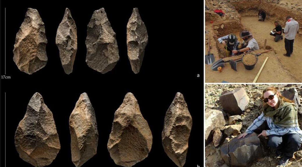
200,000-year-old tools from Stone Age unearthed in Saudi Arabia
A team of Saudi scientists from the Heritage Authority recently discovered stone tools used by the inhabitants of Assyrian civilization in the Paleolithic time period that date back to 200,000 years.
While exploring the site near Shuaib Al-Adgham in the Al-Qassim area, the Heritage Authority found a range of Neolithic tools: iron knives, scrapers, axes, and stone pierce tools from the Middle Paleolithic period.
These are unique and rare stone axes that were characterized by the high precision in manufacturing that these human groups used in their daily life.
The abundance of stone tools discovered from this site indicated the numerical density of prehistoric communities that lived in this region.
It is also a clear indication that the climatic conditions in the Arabian Peninsula were very suitable for these human groups as they benefited from the natural resources available therein.
The satellite images showed that the Shuaib Al-Adgham and other sites were connected with passages of rivers to confirm that humans used rivers to reach deep into the interior regions of the Arabian Peninsula in ancient times.
According to the wide spatial distribution of the Assyrian sites, they were the largest concentrations of human inhabitance worldwide.
It also indicates that human groups in the Arabian Peninsula were able to cross through vast swathes of geographical distances, while the large number of sites centered around ancient valleys and rivers indicated that these groups were gradually spreading and discovering new sites when they needed them.
These sites were characterized by the spread of broken stone fragments and manufactured tools.
The authority stated that a huge amount of new environmental and cultural information has been collected, and the results showed that there were significant changes in the environments, ranging from very arid to humid.
The current evidence strongly supports the assertions of the existence of the “Green Arabian Peninsula” many times in the past.
During the wet phases of human civilizations, there were rivers and lakes throughout the Arabian Peninsula, which led to the spread and expansion of these human groups.
This confirms that the Arabian Peninsula was a major crossroads between Africa and the rest of Asia throughout prehistoric times and that it was one of the places of settlement in the period of the Stone Ages.
It is believed that the ancient migrations of these human groups were through two main passages — the Bab Al-Mandab Strait and the Sinai Peninsula Corridor.
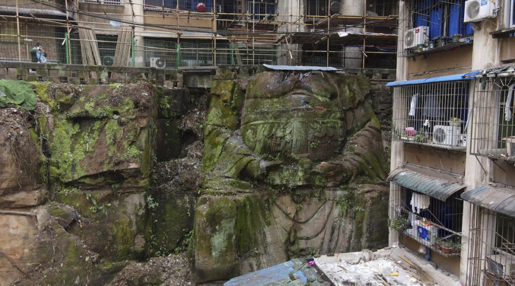
Giant Headless Buddha Statue found Beneath Chinese Apartments
In the old neighborhood of Chongqing, southwest China, people had passed by two residential buildings constructed upon a steep hill, indifferent to what lay underneath. It turns out that these two apartment buildings that sit upon the cliff face had been carved by Lord buddha.
The massive statue — about 30-feet tall and with its head missing — was hidden by a dense coating of foliage, and only exposed during recent repairs to the residential building, according to the local Nan’an district government.
Photos of the enigmatic headless sculpture have gone viral on Chinese social media since the accidental discovery, where many have referred to it as “the Buddha,” attracting headlines and stirring instant curiosity in its history and origins.
The seated Buddha sculpture uncovered in Chongqing is missing its head.
Now only partially covered in moss, the statue is depicted seated with its forearms resting on its lap and its hands holding what appears to be a round stone. The folds and some details of the figure’s clothes are also visible.
The statue is believed to have been built during China’s Republican era (1912-1949), according to a national survey of cultural relics.
While that study was conducted just over a decade ago, the sculpture had been neglected and appears to have been completely forgotten until recently.
Its head was likely destroyed during the 1950s, and the apartment buildings around it were built in the 1980s, said the district government on China’s Twitter-like platform, Weibo.
The ‘Buddha’ statue (location identified with the red square) used to be covered by dense foliage. ( Weibo)
However, experts invited by the district’s cultural relics management office to study the statue said it was not of Buddhist origin and is likely related to folk religion.
A temple dedicated to the Daoist god of thunder was once built next to the statue, though it was dismantled in 1987, the district government told state-run media outlet The Paper.
The religious statue was already designated as a district-level cultural relic before 1997, it added.
That the statue could be so quickly hidden is perhaps, a reflection of the rapid urban expansion that has unfolded in Chongqing.
In recent decades, countless structures have been built to accommodate a bustling population of over 30 million people, sometimes at the expense of historical and cultural relics. Because of the city’s mountainous terrain, many homes are built on hillsides.
Revealed: Cambodia’s vast medieval cities hidden beneath the jungle
Archaeologists in Cambodia have found multiple, previously undocumented medieval cities not far from the ancient temple city of Angkor Wat, the Guardian can reveal, in groundbreaking discoveries that promise to upend key assumptions about south-east Asia’s history.
The Australian archaeologist Dr Damian Evans, whose findings will be published in the Journal of Archaeological Science, will announce that cutting-edge airborne laser scanning technology has revealed multiple cities between 900 and 1,400 years old beneath the tropical forest floor, some of which rival the size of Cambodia’s capital, Phnom Penh.
Invisible city
For centuries, the Angkor region’s wealth of artefacts drew looters, archaeologists. They focused their attention, both good and ill, on Angkor Wat and a few other nearby moated temple complexes. Based on those ruins, the first European explorers to encounter Angkor in the 19th century assumed Khmer urbanites lived in what were basically moated cities of a few thousand people. These European explorers thought Angkor Wat was something like a medieval walled city in Europe, which typically held fewer than 10,000 people. They explained all the moated complexes in the Angkor area by suggesting that maybe the royal family and their people were moving from one moated city to the next overtime. But as archaeologists learned more in the intervening century, something about those population numbers seemed off. Beyond the moated cities were vast canal systems and reservoirs hinting at something bigger.
The ruins of Preah Khan of Kompong Svay covered with forest. An urban network was revealed by the lidar imagery around this temple.
Unfortunately, most of Angkor had become a tangle of jungles and small farms by the 20th century. There was little evidence of medieval settlements beyond the moats’ precise edges. Even if explorers were willing to hack through the dense growth, there was little to find. In a Khmer city, only the temples were made from stone. Everything else was built from perishable materials like wood. All that remained of Angkor’s homes and other non-religious structures were the elevated clay mounds of their foundations, which had been designed to prevent flooding during Cambodia’s intense wet season. Most of the city’s dramatic waterworks for flood runoff and water storage had been reduced to pits and troughs in the Earth. It was practically impossible to identify a medieval Angkorian house deep within the jungle.
All that changed when airborne LiDAR (for “Light Imaging, Detection, And Ranging”) came into common use for mapping in the early 2000s. Archaeologists working in Cambodia immediately seized on it. By scattering light off the surface of the planet, LiDAR systems can produce maps with accuracy down to the centimetre even if the ground is covered in heavy vegetation. The system is ideal for a place like Angkor, where the city’s remains are cloaked in vegetation and characterized almost entirely by elevated or depressed plots of ground.
The LiDAR rig was a Leica ALS70 HP instrument, mounted in a pod attached to the right skid of a Eurocopter AS350 B2 helicopter along with a 60 megapixel Leica RCD30 camera.
With funding from the National Geographic Society and European Research council, archaeologist Damian Evans and his colleagues conducted broad LiDAR surveys of Angkor in 2012 and 2015. The team’s mapping rig consisted of a Leica ALS70 HP LiDAR instrument mounted in a pod attached to the right skid of a Eurocopter AS350 B2 helicopter alongside a 60 megapixel Leica RCD30 camera. It was as if an invisible city suddenly appeared where only overgrowth and farmland existed before. For the first time in centuries, people could discern Angkor’s original urban grid. And what they saw changed our understanding of global history.
Archaeological researcher Piphal Heng, who studies Cambodian settlement history, told Ars that the LiDAR maps peeled back the forest canopy to reveal meticulous grids of highways and low-density neighbourhoods of thousands of houses and pools of water. There was “a complex urban grid system that extended outside the walls of Angkor Thom and other large temple complexes such as Angkor Wat,Preah Khan, and Ta Prohm,” he said. With the new data, scientists had solid evidence that the city of Angkor sprawled over an area of at least 40 to 50 square km. It was home to almost a million people. The scattered, moated complexes like Angkor Wat and Angkor Thom were merely the most enduring features of what we now know was the biggest city on Earth during the 12th and 13th centuries.
This aerial photo shows what Angkor Wat looks like today, surrounded by vegetation and a few areas of modern farms and homes. None of the vast city grid from 800 years ago is visible.
In the LiDAR map, you can clearly see the central urban grid of Angkor extending from Angkor Thom (top left) and Angkor Wat (bottom left).
Here you can see the areas covered by the LiDAR surveys in 2012 and 2015.
A map of the greater Angkor area, showing the extent of the urban sprawl revealed by LiDAR.
From legend to reality
The city of Angkor has its origins in the ninth century during the reign of Jayavarman II. He unified large parts of Southeast Asia by establishing the Khmer Empire across regions we know today as Cambodia, Thailand, Vietnam, and Laos. Inscriptions on temple walls at Sadok Kok Thom in Thailand describe how he established a city called Hariharalaya, located near Siem Reap in the Angkor area. But the inscriptions also say that Jayavarman II declared himself a supreme ruler or “god-king” in a lavish Hindu ceremony held at his residence on Kulen Mountain in a city called Mahendraparvata. Accounts of the Kulen Mountain phase in Jayavarman’s life are so sparse and fantastical that debates have raged among scholars about whether he actually lived in Mahendraparvata at all.
To find out more, archaeologists targeted Kulen Mountain in their latest LiDAR survey. Evans published some of the first results from this 2015 survey in the Journal of Archaeological Science. Royal Academy of Cambodia archaeologist Kaseka Phon explained to Ars via e-mail that the LiDAR has uncovered an Angkor-like city grid at the abandoned city of Mahendraparvata on Kulen Mountain. Plus, the LiDAR “shows not only features of the construction, but also water features” that are clearly versions of Angkor’s incredible water management facilities. The new survey revealed massive stone quarries, now filled in, that produced the rock used to build some of the temples of Angkor. Kulen Mountain’s role in the birth of the Khmer Empire is no longer a legend—it’s an established historical fact.
This transformation of legend into fact has been a theme of the LiDAR surveys. Angkor’s huge population is described in temple inscriptions and reports written by Chinese travellers who visited the city during the 12th-century reign of King Suryavarman II, who built Angkor Wat. But historical sources are often exaggerated or incomplete. Plus, it was difficult for Western researchers to believe that the Khmer Empire’s great city was home to almost a million people, dwarfing European cities of the same era. Now, such facts are impossible to deny.
Angkor city planning
Angkor reached megacity proportions in the 12th century when Suryavarman II ordered the construction of Angkor Wat (which he dedicated to the Hindu god Vishnu). At that time, the urban sprawl in Angkor was not only enormous, but it was centrally planned with rigorous precision. Heng told Ars that “the shape of roads, walls, moats, mounds, and ponds were probably made based on urban templates commissioned by the Angkorian rulers” while residents of different neighbourhoods probably had different degrees of freedom to modify those plans. Heng continued:
At temples such as Angkor Wat and Ta Prohm, the grid usage was significantly varied. For example, based on our recent excavations, after the urban grid was laid out, there is little evidence of modification—if at all—in a series of habitation mounds inside Angkor Wat. While for Ta Prohm, its inhabitants seem to have more freedom in modifying parts of their gridded mounds.
To learn more about everyday life in Angkor Wat, University of Illinois Urbana-Champaign archaeologist Alison Carter has done excavation work on some of the residential mounds inside the enclosure. In 2015, she got funding from the National Geographic Society to excavate one of the residential mounds identified via LiDAR. Carter discovered what appears to be the remains of a brick stove, complete with ceramic vessels for cooking. Chemical analysis revealed remains of pomelo fruit rind, seeds from a relative of the ginger plant, and grains of rice. This is what archaeologists call “ground-truthing,” and it’s further confirmation that the mounds we see in LiDAR are actually from households rather than other structures.
The picture that’s emerging of Angkor is much like a modern low-density city with mixed-use residential and farm areas. As Evans put it to Ars, “in the densely inhabited downtown core there are no fields, but that nice, formally planned city centre gradually gives way to an extended agro-urban hinterland where neighbourhoods are intermingled with rice-growing areas, and there is no clear distinction between what is ‘urban’ or ‘rural’.” The city was a miracle of geoengineering with every acre transformed by human hands, whether for agriculture or architecture.
Perhaps Angkor’s greatest technological achievement was its sophisticated waterworks, including artificial canals and reservoirs. People strolling through the city 800 years ago would have passed through neighborhoods whose carefully arranged homes were built alongside rainfall ponds for families, as well as enormous canals for the city as a whole. Massive rectangular reservoirs held water all year around for agricultural use.
Each neighbourhood would have looked slightly different, though all relied on the same water infrastructure. The city had to survive the floods of the rainy season and slake the thirst of people and farms in the dry season. For centuries, it accomplished this incredible feat, which modern cities still struggle with. Suryavarman II ruled a city whose mythic proportions were enabled by the most sophisticated engineering techniques of his day.
Comparison of major temple complexes in the 12th to 13th centuries, all at the same scale. Later developments (right column) show more variable grids than earlier ones (left column), with areas within the moat divided neatly into ~100×100 m “city blocks.” 6a: Angkor Wat. 6b: Beng Mealea. 6c: Preah Khan of Kompong Svay. 6d: Preah Khan of Angkor. 6e: Ta Prohm. 6f: Banteay Chhmar.
“Mound fields” across Cambodia. Panels a,b are in the Phnom Kulen area. Panels c,d are immediately to the north of the main temple complex at Sambor Prei Kuk. Panels e,f are Immediately to the west of Banteay Srei temple at Angkor. Panels g,h: Near the exit of the East Baray reservoir at Angkor, new archaeological mapping (3g) based on the 2012 ALS data has added further detail to a ~10×10 grid of mounds (3h) and revealed a second mound field to the south of the exit. Panels 3a,c and e are conventional aerial imagery acquired in the 2015 campaign. Panel 3g is based on archaeological maps by Damian Evans, Christophe Pottier and Pelle Wijker.
Unexplained, rectangular coil patterns associated with major temples across northwest Cambodia, revealed in LiDAR maps.
Mysterious coils and mounds
Plenty of unknowns remain at Angkor, and the LiDAR surveys have revealed two previously unseen structures that nobody has been able to explain so far. The first is a complicated rectangular maze pattern dubbed the “coils,” “spirals,” or “geoglyphs.” These were first spotted outside the moat at Angkor Wat during the 2012 survey, but the 2015 survey revealed similar coils outside the enclosures at Beng Mealea and Preah Khan. At first glance, they appear to be waterworks, but Evans and his colleagues dismissed that idea because they are too shallow and are cut off from the city’s general waterworks.
Currently, the reigning hypothesis is that these rectilinear coils were specialized gardens for growing plants used in temple rituals. The often-flooded channels might have contained lotus, while the raised areas could have supported “aromatics such as sandalwood trees.”
More mysterious are the so-called “mound fields” found near some of Angkor’s largest reservoirs and canals. Unlike the residential mounds excavated by Carter and her colleagues, these mounds aren’t packed with ceramics and food remains. They are just mounds, clearly the foundations for an elevated structure or structures. Their locations suggest that they may have been related to the city’s waterworks, but of course, correlation does not equal causation. Further research is needed to unlock the secrets of the coils and mound fields.
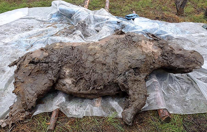
Scientists uncover 20,000-year-old Ice Age woolly rhino in Russia
During a search in Russia’s permafrost, an animal dating back at least 20,000 years was discovered and it is over 80% preserved and straight-up wild to see. The woolly rhinoceros (Coelodonta antiquitatis) was once a common species throughout Europe and Northern Asia.
On average, they were between 9.8 to 12.5 ft from head to tail and would weigh between 4,000 and 6,000 pounds once fully grown. Their closest living genetic relative is the Sumatran rhinoceros but looking at a picture of them they almost appear as if a unicorn made babies with an American buffalo.
These Wooly Rhinos had two horns, one big and one small(er). The bigger horn would measure up to 4.6 feet and the horn itself would weigh over 33 pounds.
As you can tell, I’m learning all of this on the fly because I’ve only ever heard of this species once before today. It’s not like this is one of those animals they taught us about in elementary school.
Well, according to the Siberian Times, archaeologists found a juvenile (estimate 3 to 5 years old) wooly rhino ‘in permafrost deposits by river Tirekhtyakh in the Abyisky ulus (district) of the Republic of Sakha.’ I did a quick search on Google Maps of that location and it’s in eastern Russia almost straight north of North Korea.
It is a little grizzly. After all, it’s a 20,000+ year old animal and not a newborn bunny. But it’s crazy to see how intact it is:
It is the best preserved to date juvenile woolly rhino ever found in Yakutia, with a lot of its internal organs – including its teeth, part of the intestines, a lump of fat and tissues – kept intact for thousands of years in permafrost
The juvenile rhino with thick hazel-colored hair and the horn, found next to the carcass was discovered in the middle of August in permafrost deposits by river Tirekhtyakh in the Abyisky ulus (district) of the Republic of Sakha.
The sensational discovery is still in the Arctic Yakutia waiting for ice roads to form so that it can be delivered to scientists in the republic’s capital Yakutsk.
It is the best-preserved to date juvenile woolly rhino ever found in Yakutia, with a lot of its internal organs – including its teeth, part of the intestines, a lump of fat and tissues – kept intact for thousands of years in permafrost.
‘The young rhino was between three and four years old and lived separately from its mother when it died, most likely by drowning’, said Dr. Valery Plotnikov from the Academy of Sciences who has been to the discovery site and made the first description of the find.
‘The gender of the animal is still unknown. We are waiting for the radiocarbon analyses to define when it lived, the most likely range of dates is between 20,000 and 50,000 years ago.
The rhino has a very thick short underfur, very likely it died in summer’, Dr. Plotnikov said. (via Siberian Times)
It’s absolutely wild that its last meal was intact in its stomach too. They are waiting on analysis of the contents from the rhino’s stomach and internal organs to try and determine what exactly it was eating.
Despite its awesome horns that I would’ve assumed was for picking up monkeys out of trees, the woolly rhinoceros primarily ate grass and sedges. Due to their massive sizes, they had to eat A LOT of grass to sustain themselves which wasn’t exactly easy during an ice age.
To read more about this fascinating discovery, you can head on over to the Siberian Times which has a lot of information about this discovery along with a few other rare discoveries from this year including two extinct cave lion cubs.
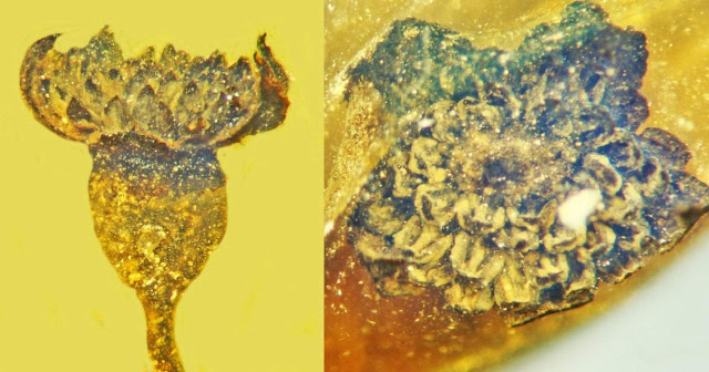
99-Million-Year-Old Fossil Flower Found Encased in Burmese Amber
Oregon State University researchers have identified a spectacular new genus and species of flower from the mid-Cretaceous period, a male specimen whose sunburst-like reach for the heavens was frozen in time by Burmese amber.
“This isn’t quite a Christmas flower but it is a beauty, especially considering it was part of a forest that existed 100 million years ago,” said George Poinar Jr., professor emeritus in the OSU College of Science.
Findings were published in the Journal of the Botanical Research Institute of Texas.
Valviloculus pleristaminis, flower in lateral view.
“The male flower is tiny, about 2 millimetres across, but it has some 50 stamens arranged like a spiral, with anthers pointing toward the sky,” said Poinar, an international expert in using plant and animal life forms preserved in amber to learn more about the biology and ecology of the distant past.
A stamen consists of an anther — the pollen-producing head — and a filament, the stalk that connects the anther to the flower.
“Despite being so small, the detail still remaining is amazing,” Poinar said. “Our specimen was probably part of a cluster on the plant that contained many similar flowers, some possibly female.”
Valviloculus pleristaminis, center of flower in apical view.
The new discovery has an egg-shaped, hollow floral cup — the part of the flower from which the stamens emanate; an outer layer consisting of six petal-like components known as tepals; and two-chamber anthers, with pollen sacs that split open via laterally hinged valves.
Poinar and collaborators at OSU and the U.S. Department of Agriculture named the new flower Valviloculus pleristaminis. Valva is the Latin term for the leaf on a folding door, loculus means compartment, plerus refers to many, and staminis reflects the flower’s dozens of male sex organs.
The flower became encased in amber on the ancient supercontinent of Gondwana and rafted on a continental plate some 4,000 miles across the ocean from Australia to Southeast Asia, Poinar said.
Geologists have been debating just when this chunk of land — known as the West Burma Block — broke away from Gondwana. Some believe it was 200 million years ago; others claim it was more like 500 million years ago.
Numerous angiosperm flowers have been discovered in Burmese amber, the majority of which have been described by Poinar and a colleague at Oregon State, Kenton Chambers, who also collaborated on this research.
Angiosperms are vascular plants with stems, roots and leaves, with eggs that are fertilized and develop inside the flower.
Since angiosperms only evolved and diversified about 100 million years ago, the West Burma Block could not have broken off from Gondwana before then, Poinar said, which is much later than dates that have been suggested by geologists.
Joining Poinar and Chambers, a botany and plant pathology researcher in the OSU College of Agricultural Sciences, on the paper were Oregon State’s Urszula Iwaniec and the USDA’s Fernando Vega.
Iwaniec is a researcher in the Skeletal Biology Laboratory in the College of Public Health and Human Sciences and Vega works in the Sustainable Perennial Crops Laboratory in Beltsville, Maryland.
Traces of Possible Neolithic Tsunami Found in Israel
Prehistoric tsunami disasters had a significant impact on coastal societies,” said lead author Dr Gilad Shtienberg from the Department of Anthropology at the University of California, San Diego, and colleagues at the Scripps Center for Marine Archaeology.”
“6,000 years of historical records and geological data show that tsunamis are a common phenomenon affecting the eastern Mediterranean coastline, occurring at a rate of around 8 events per century in the Aegean region over the past 2,000 years and approximately 10 per century over the past 3,000 years in the Levant basin.”
“Most of these events are small and have only local impacts.”
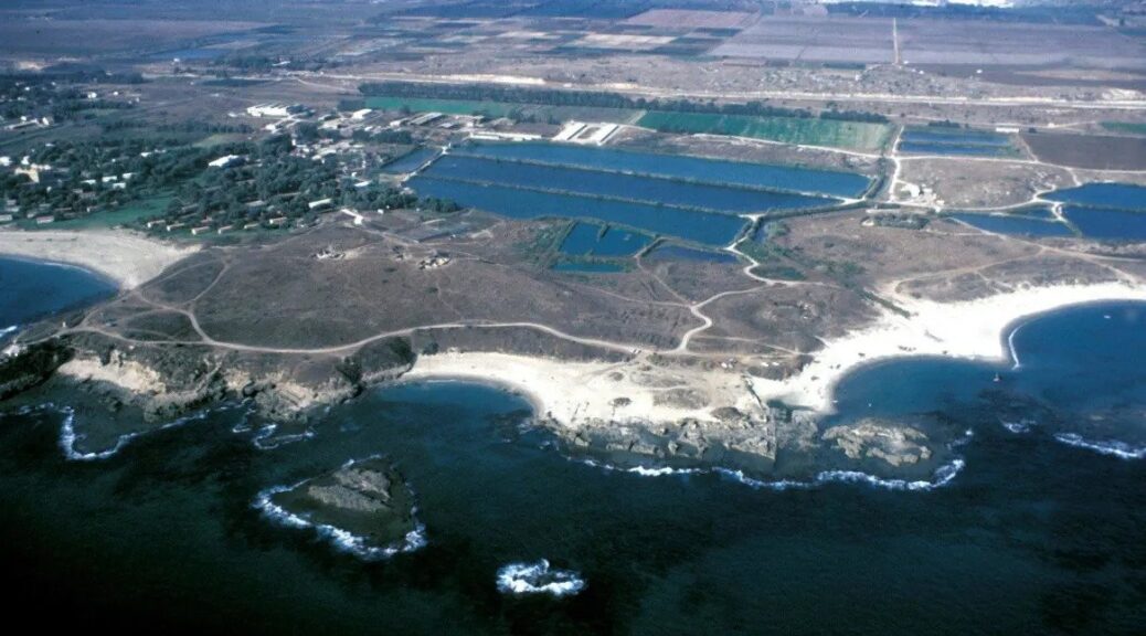
In the study, the researchers found a large paleo-tsunami deposit (between 9,910 to 9,290 years ago) at the archaeological site of Tel Dor in northwest Israel.
“Tel Dor, located along the Carmel coast of northwest Israel, is a maritime city-mound that has been occupied from the Middle Bronze II period (2000 to 1550 BCE) throughout the Roman period (3rd century CE) while Byzantine and Crusader remains are also found on the tel,” they said.
“The local environment of Dor is characterized by a series of unique embayments/pocket beaches that stand out from the linear morphology of the southeastern Mediterranean littoral shoreface.”
To conduct their analysis, the scientists used photogrammetric remote sensing techniques to create a digital model of the Tel Dor site, combined with underwater excavation and terrestrial borehole drilling to a depth of 9 m (29.5 feet).
In their samples, they found an abrupt layer of seashells and sand, dated to between 9,910 and 9,290 years ago, in the middle wetland layers deposited 15,000 to 7,800 years ago.
They estimate that the ancient tsunami had a run-up of at least 16 m and travelled between 3.5 to 1.5 km inland from the paleo-coastline.
The near absence of Pre-Pottery Neolithic A-B archaeological sites (11,700-9,800 years ago) suggest these sites were removed by the tsunami, whereas younger, late Pre-Pottery Neolithic B-C (9,250-8,350 years ago) and later Pottery-Neolithic sites (8,250-7,800 years ago) indicate resettlement following the event.
“We can’t know for sure why people weren’t living there, in a place otherwise abundant with evidence of early human habitation and the beginnings of village life in the Holy Land,” said Professor Thomas Levy, a researcher in the Department of Anthropology and the Levant and Cyber-Archaeology Laboratory in the Scripps Center for Marine Archaeology at the University of California, San Diego.
“Was the environment too altered to support life? Was the tsunami part of their cultural knowledge — did they tell stories of this destructive event and stay away? We can only imagine.”
“Our project focuses on reconstructing ancient climate and environmental change over the past 12,000 years along the Israeli coast, and we never dreamed of finding evidence of a prehistoric tsunami in Israel,” Dr Shtienberg said.
“Scholars know that at the beginning of the Neolithic, around 10,000 years ago, the seashore was 4 km (2.5 miles) from where it is today.”
“When we cut the cores open in San Diego and started seeing a marine shell layer embedded in the dry Neolithic landscape, we knew we hit the jackpot.”