Archaeologists Find Ancient Golden Neck Ring Dating Back To Germanic Iron Age
In a very amusing discovery, an ancient golden neck ring has been found in a field near Esbjerg on the Jutland Peninsula in mainland Denmark.
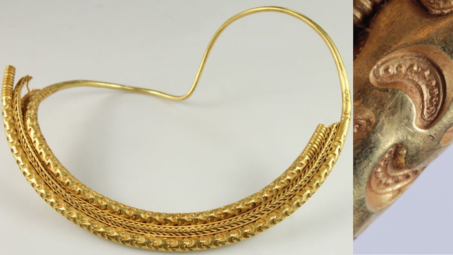
According to a report published in Sputnik, the archaeologists estimate that it belongs to the Germanic Iron Age 1,400–1,700 years ago and it weighs around half a kilo (446 grams), which is designed with crescent-like depressions. The broadest point of the ring measures 21 centimetres in diameter.
The archaeologists observed that the decoration found on the ring is quite rare, which makes it a “masterpiece of almost divine quality,” as termed by the South West Jutland Museum.


The experts noted that the ring was deliberately buried and hidden away and that the inhabitant to whom it belonged did not sacrifice the ring to the gods, which was common practice in that era.
Ancient golden neck ring ‘of almost divine quality’ found in Denmark
“When sacrificing items at that time, it usually took place in wetlands, bogs, and the like. We know a large wetland existed near the discovery site, so if it was sacrificed to the gods, it would have been located out there instead, “said Claus Feveile, curator at Museet Ribes Vikinger in a statement.
After examining the metal, Feveile noted that the metal had moved from its place for a very long time, as the neck ring is still in excellent condition and its shape or size has not been distorted.
“The gold is so pure and therefore so soft that the ring would not have been able to keep its shape as nicely as it has if it had been moved around with tools.

At the same time, the excavation shows that we have found the very hole in which the neck ring was hidden,” reported Sputnik.
READ ALSO: RESEARCHERS DATE HORNED HELMETS DISCOVERED IN DENMARK
Archaeologists’ observations
After examining the neck ring, Claus Feveile suggested that the ancient jewellery was hidden by the owner, as they may not have wanted to lose it, or planned to dig it up again sometime later.
However, something unexpected must have happened, and the owner of that masterpiece never came to reclaim it, the archaeologist concluded. The neck ring will be kept for exhibition at the Ribe Viking Museum.