Scientist Finds Hidden Portraits Underneath “Mona Lisa”
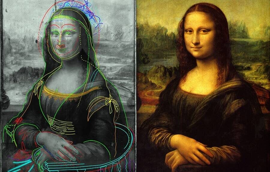
Forget everything you know about the most famous painting in the world: Leonardo da Vinci’s Mona Lisa (1503–17). According to French scientist Pascal Cotte, who has analyzed the painting by reflecting light technology for over 10 years, the Mona Lisa hides another portrait underneath.
According to the BBC, the most surprising of Cotte’s findings is that the sitter in the original painting found underneath has no trace of the enigmatic smile that elevated da Vinci’s portrait to the category of myth.
The sitter is also looking off to the side, rather than towards the viewer like the Mona Lisa we know and love today.

Cotte’s pioneering technology is called Layer Amplification Method (LAM) and has allowed him to make a slew of groundbreaking discoveries. It works by projecting a series of intense lights onto an artwork while a camera measures the reflections.
Last year, he already made waves among the art historical community when he revealed that another da Vinci masterpiece, Lady With an Ermine (1489–90) was painted not in one, but in three clearly differentiated stages.

“The LAM technique gives us the capability to peel the painting like an onion, removing the surface to see what’s happening inside and behind the different layers of paint,” he told the BBC back then.
Crucially, this “new” Mona Lisa has ramifications also in terms of the identity of the sitter. For years and years, it’s been debated whether the woman in the painting might have been Lisa Gherardini, the wife of a Florentine silk merchant, da Vinci’s mother, or even a Chinese slave.
Cotte, complicating things even further, told the BBC: “When I finished the reconstruction of Lisa Gherardini, I was in front of the portrait and she is totally different from Mona Lisa today. This is not the same woman.”
Not everyone agrees with Cotte, however. Da Vinci expert Martin Kemp, Emeritus Professor of the History of Art at the University of Oxford, told the BBC: [Cotte’s images] are ingenious in showing what Leonardo may have been thinking about.
But the idea that there is that picture as it was hiding underneath the surface is untenable. I do not think there are these discreet stages that represent different portraits. I see it as more or less a continuous process of evolution. I am absolutely convinced that the Mona Lisa is Lisa.”
Cotte’s findings will be presented in a documentary called The Secrets of the Mona Lisa that will be broadcast on BBC Two.
The famous art historian Andrew Graham-Dixon, who’s behind the documentary, said of the discovery: “I have no doubt that this is definitely one of the stories of the century.”
This could be the second claim in less than two weeks that changes common perspectives on celebrated artworks by da Vinci.
In late November, the notorious British art forger Shaun Greenhalgh publicly claimed to be the author of La Bella Principessa, a $150 million painting attributed to Leonardo da Vinci.