According to a Nature report, a team of researchers led by Bin Han of the University of the Chinese Academy of Sciences identified a bronze vessel containing remnants of a 2,700-year-old cosmetic among the artifacts recovered from a nobleman’s tomb at the Liujiawa site in northern China.
The ornate bronze jar was still sealed when researchers unearthed it at the Liujiawa archaeological site in northern China. That allowed Yimin Yang at the University of the Chinese Academy of Sciences in Beijing and his colleagues to analyze the composition of the yellowish lumps inside the pot.
The lumps consisted of beef fat mixed with minerals that absorb sweat and skin oil. Those minerals came from ‘cave moon milk’, a powdered form of white stalactites found in limestone caves.
Caves were important to the Taoist philosophy prevalent during the nobleman’s day, and the cream would have had symbolic power as well as the ability to moisturize and whiten the face.
The presence of similar pots in many royal and noble graves suggests that a cosmetics industry serving elite customers had appeared in China by roughly 700 BC.
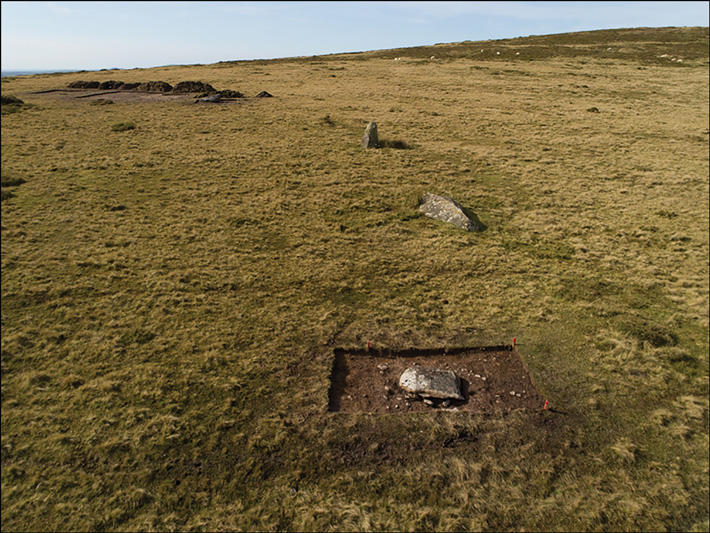
Traces of a Neolithic stone circle have been discovered in west Wales, near ancient bluestone quarries in the Preseli Hills, by a team of researchers led by Mike Parker Pearson of University College London, according to a Science Magazine report.
Around 3200 B.C.E., Stone Age farmers in Wales’s Preseli Hills built a great monument: They carved columns of unspotted dolerite, or bluestone, from a nearby quarry, then thrust them upright in a great circle aligned with the Sun. Exactly what the circle meant to them remains a mystery.
But new research reveals that several centuries later, their descendants took down many of the giant stones and hauled them 200 kilometers to the Salisbury Plain, where they created what is still the world’s most iconic prehistoric stone monument: Stonehenge.
A few toppled bluestones are visible at the prehistoric stone circle of Waun Mawn in Wales
The paper’s authors “make a very good argument Stonehenge is a dismantled stone circle from Wales,” says Alison Sheridan, a curator emerita at the National Museum of Scotland who was not part of the research team. “They dealt with very tricky data but came up with a brilliant hypothesis.”
Researchers had already traced Stonehenge’s slabs of bluestone to the west coast of Wales; they’d even identified some of the quarries where the stones were extracted more than 5,000 years ago.
But radiocarbon dating showed a puzzling gap of several centuries between activity at the bluestone quarries and the earliest construction at Stonehenge.
Researchers wondered whether the distinctive, 2- to 3-meter-tall bluestones had been used to build other stone circles first, then moved to Stonehenge later. “They’re clearly not spending 200 years slowly moving them across the landscape,” says University of Southampton archaeologist Joshua Pollard, one of the co-authors. “It always seemed likely they were dismantling existing monuments.”
Over the past decade, researchers led by University College London archaeologist Michael Parker Pearson searched for ritual structures in the Preseli region that might have provided the stones—and the blueprint—for Stonehenge. In 2017 and 2018, they excavated parts of an ancient monument called Waun Mawn, where a handful of toppled bluestones similar to those at Stonehenge form a partial circle.
The excavations revealed distinctive socket-shaped pits where other stones had once stood. Connecting the dots between the empty sockets and toppled bluestones at Waun Mawn, researchers sketched out a circle 110 meters across—the same dimensions as the outer earthen ditch that was part of Stonehenge’s original layout. (The ritual center was rearranged multiple times over its 1000 year life span.) And, like at Stonehenge, the circle’s entrance was oriented toward sunrise on the midsummer solstice.
Parker Pearson’s team then measured the last time sediments inside the socket holes at Waun Mawn had been exposed to light, using optically stimulated luminescence; they also radiocarbon dated charcoal found inside the pits.
They estimate the missing stones were erected between 3400 and 3200 B.C.E. and then removed 300 or 400 years later, around the time the first construction at Stonehenge began, they report today in Antiquity. “We’re quite confident the reason they come down is they’ve gone to Stonehenge,” says Parker Pearson.
Researchers say the dismantling of Waun Mawn and the rise of Stonehenge could have been part of a larger migration from the Preseli Hills to the Salisbury Plain. Human and animal remain found at Stonehenge have chemical signatures suggesting their early years were spent on the Welsh coast. “We’ve got regular contact between the two regions,” Pollard says.
The results add to an emerging picture of Stonehenge’s origins in a complex, interconnected region centered on the Irish Sea that flourished in the fourth millennium B.C.E., Sheridan says.
“People and ideas and objects were moving over long distances, and the movement clearly had to do with the way society expressed power,” Sheridan says. “Uprooting stones is a classic example.”
Back in the Preseli Hills region, radiocarbon dates and pollen evidence suggest that millennia of farming and human occupation ended around the time the Waun Mawn circle was dismantled. “Evidence for human activity drops around 3400 B.C.E.,” Parker Pearson says, though researchers aren’t sure why the people left.
The researchers say the migrants from Wales might have relocated the stones as a way to stay symbolically connected to their past—or to draw on their ancestors’ authority to claim a new region. “They’re bringing ancestral symbols as an act of unification,” Parker Pearson says.
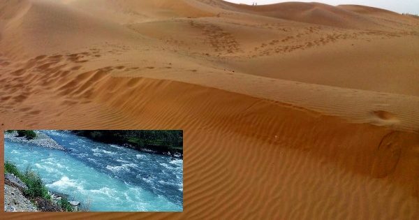
Lost Civilization? 172000 Year Old River Discovered in Thar Desert India
Researchers have found evidence of a “lost” river that ran through the central Thar Desert, near Bikaner, as early as 172 thousand years ago, and may have been a life-line to human populations enabling them to inhabit the region. The findings, published in the journal Quaternary Science Reviews, represent the oldest directly dated phase of river activity at Nal Quarry in the central Thar Desert.
The study by researchers from The Max Planck Institute for the Science of Human History in Germany, Anna University in Tamil Nadu, and IISER Kolkata indicates that Stone Age populations lived in a distinctly different Thar Desert landscape than we encounter today.
This evidence indicates a river that flowed with phases of activity dating to approximately up to 172 thousand years ago, nearby to Bikaner, Rajasthan, which is over 200 kilometers away from the nearest modern river.
Sand Dunes in Bikaner, Rajasthan
These findings predate evidence for activity in modern river courses across the Thar Desert as well as dried up course of the Ghaggar-Hakra River, the researchers said. The presence of a river running through the central Thar Desert would have offered a life-line to Paleolithic populations, and potentially an important corridor for migrations, they said.
The researchers noted that the potential importance of ‘lost’ rivers for earlier inhabitants of the Thar Desert has been overlooked.
“The Thar Desert has a rich prehistory, and we’ve been uncovering a wide range of evidence showing how Stone Age populations not only survived but thrived in these semi-arid landscapes,” said Jimbob Blinkhorn from The Max Planck Institute for the Science of Human History.
“We know how important rivers can be to living in this region, but we have little detail on what river systems were like during key periods of prehistory,” Blinkhorn said.
Studies of satellite imagery have shown a dense network of river channels crossing the Thar Desert, according to the researchers.
“These studies can indicate where rivers and streams have flowed in the past, but they can’t tell us when,” explained Professor Hema Achyuthan of Anna University.
“To demonstrate how old such channels are, we had to find evidence on the ground for river activity in the middle of the desert,” Achyuthan said.
The team studied a deep deposit of river sands and gravels, which had been exposed by quarrying activity near the village of Nal. The researchers were able to document different phases of river activity by studying the different deposits.
“We immediately saw evidence for a substantial and very active river system from the bottom of the fluvial deposits, which gradually decreased in power through time,” Achyuthan said.
The researchers used a method called luminescence dating to understand when quartz grains in the river sands were buried. The results indicated that the strongest river activity at Nal occurred at approximately 172 and 140 thousand years ago, at a time when the monsoon was much weaker than today in the region.
River activity continued at the site between 95 to 78 thousand years ago, after which only limited evidence for the presence of a river at the site, with evidence for a brief reactivation of the channel 26 thousand years ago, the study found.
The river was flowing at its strongest during a phase of weak monsoonal activity in the region, and may have been a life-line to human populations enabling them to inhabit the Thar Desert, the researchers said.
The timeframe over which this river was active also overlaps with significant changes in human behaviour in the region, which have been linked with the earliest expansions of Homo sapiens from Africa into India, they said.
“This river flowed at a critical timeframe for understanding human evolution in the Thar Desert, across South Asia and beyond,” said Blinkhorn.
“This suggests a landscape in which the earliest members of our own species, Homo sapiens, first encountered the monsoons and crossed the Thar Desert may have been very different to the landscape we can see today,” he added.
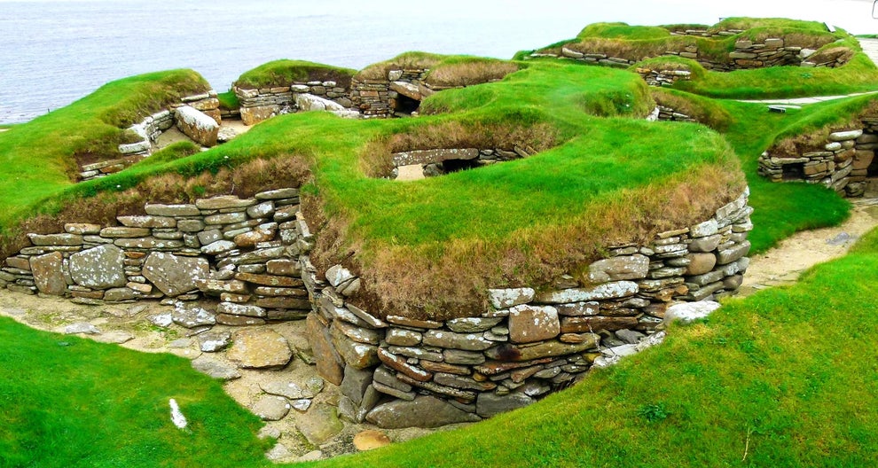
Erosion Reveals Possible Neolithic Village Site in Scotland
The Scotsman reports that erosion on the island of Orkney at the northern end of the Bay of Skaill has exposed deer antlers, a boar tooth, a cattle jawbone, and a large stone marked with incised triangles and a series of rectangular bands.
The artifacts were found about a half-mile away from the site of the Neolithic village of Skara Brae, which is located at the bay’s southern end.
Skara Brae is considered the best-preserved Neolithic settlement in Western Europe with people first making their home there around 3,100BC.
It was discovered in 1850 when a storm exposed part of the coastal site. Now, almost 170 years later, coastal erosion may have uncovered its neighbour.
A section of badly damaged wall has been exposed by the work of the pounding tides at the north end of the Bay of Skaill. Deer antlers, a boar tooth, a cattle jawbone, and a large decorated stone have also been discovered.
A boar tusk found at the north end of the Bay of Skaill.
Sigurd Towrie, the spokesman for the Archaeology Institute at the University of Highlands and Islands, said the finds “suggest there is another settlement at the Bay of Skaill – one that, from previous environmental sampling, is likely to be 4,000 to 5,000 years old”.
He said: “If this is the case, and based on the scale of the eroded section, we may well be looking at a Neolithic/Bronze Age site on a par with Skara Brae – albeit one that is now disappearing at an alarming rate.”
The large decorated stone found on the beach, which is similar to those found at Skara Brae.
The large decorated stone was discovered in the Bay of Skaill by Mr. Towrie after he noticed animal remains falling from an eroding section of shoreline.
Closer inspection found the stone marked with a pair of incised triangles and a series of rectangular bands running across the surface.
Dr. Antonia Thomas, the Archaeology Institute’s rock art specialist, confirmed the find was potentially a carved stone – one with designs similar to those recorded at Skara Brae.
The Bay of Skaill, where evidence of another potential Neolithic settlement has emerged.
It has long been thought that more Neolithic settlements may have dotted the bay surrounding Skara Brae. During building work in the 1930s, a wall was discovered to the north of the bay along with midden material, animal bone, and four burials, which were later moved.
The new finds have refreshed interest in who may have lived around the bay during the New Stone Age.
The discovery of deer remains is an unusual find for a Neolithic site on Orkney, with the animal perhaps used for rituals rather than food, it is understood.
The Bay of Skaill is now under close observation from the archaeology institute, although an excavation is unlikely in the near future given restrictions imposed by the coronavirus pandemic.
A section of wall which has been exposed at the Bay of Skaill which may have been part of an undiscovered Neolithic settlement.
The cow mandible recovered from the eroding shoreline section. Towrie discovered the stone while visiting the Bay of Bay Skaill after she noticed animal remains falling from an eroding section of shoreline
Mr. Towrie said: “UHI Archaeology Institute will continue to carefully monitor the extent of the coastal erosion and act as an when necessary.”
Skara Brae is considered the best-preserved prehistoric settlement of any period in the British Isles. Its preservation in the sand has left a vivid impression of life in a prehistoric village.
An ‘exceptional’ collection of artifacts recovered from the site tell a story of farming and fishing among its inhabitants, as well as jewellery making and crafts.
One of the houses at Skara Brae contains a hearth and stone beds. One bed, which is decorated, lies directly over the burial site of two mature women laid to rest in a crouched position.
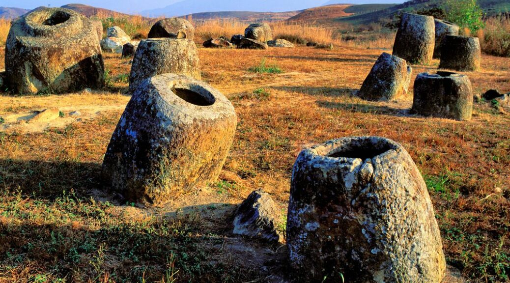
10-Foot-Tall Stone Jars ‘Made by Giants’ Stored Human Bodies in Ancient Laos
Stonehenge inspires awe, but there’s an even more mysterious ancient scene in Laos. The Plain of Jars consists of thousands of prehistoric stone vessels scattered over hundreds of square kilometres near Phonsavan, in the northeastern part of the country—a hilly area, despite the “plain” in the name. The huge jars form a surreal sight—some are up to ten feet tall and weigh several tons. It’s an archaeological wonder that experts still haven’t pinned down.
Several human burials, thought to be around 2,500 years old, have been found at some of these sites in Laos, but nothing is known about the people who originally made the jars.
An expedition of archaeologists from Laos and Australia visited the Xiangkhouang region in February and March this year to document known jar sites and to search for new jars-of-the-dead sites and stone quarries.
Local legends say the carved stone jars were created by a race of giants to brew rice beer, but archaeologists think they were used in burial rituals.
The new finds show that the mysterious culture that made the stone jars were geographically more widespread than previously thought, said Louise Shewan, an archaeologist at the University of Melbourne, and one of the expedition leaders.
The joint Australian and Laos archaeological expedition searched for new jar sites in the Xiangkhouang region and excavated a previously known jar site.
The largest and best-known jar site is the famous Plain of Jars, located in relatively open country near the town of Phonsavan. That site contains around 400 carved stone jars, some as tall as 10 feet (3 m) and weighing more than 10 tons (9,000 kilograms), and the first archaeological investigation of it was made in the 1930s.
But Shewan said that the majority of the jar sites usually contained fewer than 60 carved stone jars, and were found in forested and mountainous terrain surrounding the Plain of Jars, spread over thousands of square miles.
Ancient stone jars
Shewan told Live Science that the search for new jar sites took the expedition into “extremely rugged, forested terrain,” as the researchers looked for ancient relics reported by local people.
Relying on local knowledge meant the archaeologists could avoid the ever-present danger of unexploded Vietnam War-era bombs, she said. U.S. warplanes dropped an estimated 270 million cluster bombs on Laos during the war.
The Laos government agency that oversees clearance efforts reports that more than 80 million unexploded bombs are scattered around the country.
Although the region is best known for the stone jars on the Plain of Jars, most of the ancient jar sites are in heavily forested and mountainous areas.
The latest expedition, in addition to accurately mapping many of the reported sites in the Xiangkhouang region, found 15 new jar sites, containing a total of 137 ancient stone jars.
Shewan said that the newly discovered jars were similar to those found on the Plain of Jars, but some varied in the types of stone that they were made from, their shapes and the way the rims of the jars were formed.
Burial rituals
Local legends include a story that the enormous stone jars were made by giants, who used the vessels to brew rice beer to celebrate a victory in war. But archaeologists think that at least some of the carved stone jars were used to hold dead bodies for a time before their bones would be cleaned and buried.
Australian and Lao archaeologists found more than 137 ancient stone jars at 15 new sites in the remote and rugged Xiangkhouang region.
Although the remains of elaborate human burials have been found at some of the jar sites, archaeologists aren’t sure if the jars were made for the purpose of the burials or if the burials were performed later.
Excavations in 2016 revealed that some of the stone jars were surrounded by pits filled with human bones and by graves covered by large carved disks of stone. These appear to have been used to mark the grave locations.
The latest expedition also found buried disks and other artefacts. Those included several beautifully carved stone disks, decorated on one side with concentric circles, human figures and animals. Curiously, the stone discs were always buried with the carved side face down.
“Decorative carving is relatively rare at the jar sites, and we don’t know why some disks have animal imagery and others have geometric designs,” expedition co-leader Dougald O’Reilly, an archaeologist at Australian National University in Canberra, said in a statement.
The excavations around some of the stone jars also revealed decorative ceramics, glass beads, iron tools, decorative disks that were worn in the ears and spindle whorls for cloth making. Researchers also discovered several miniature clay jars that looked just like the giant stone jars and that were buried with the dead.
The scientists will now use the data and photographs from the new jar finds to reconstruct the sites in virtual reality at Monash University; then, archaeologists across the globe can use the VR to examine the sites in detail.
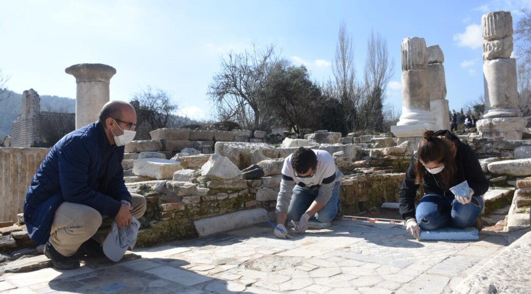
The Anadolu Agency reports that an ancient floor surface made up of at least four different colors of marble has been uncovered at the site of the ancient city of Stratonikeia in southwestern Turkey.
The latest project on a 1,550-year-old Byzantine church and its marble floors stand out as one of the most eye-catching restoration projects in the ancient city recently.
The Byzantine church at the ancient site, which is on the UNESCO Tentative World Heritage List, historically used to serve religious people with an enchantingly colorful marble floor. The excavation and restoration project at the site will restore the marble structure back to its original, glorious state.
Professor Bilal Söğüt from Pamukkale University, head of excavations at Stratonikeia and Lagina sites, said that most of their archaeological work was focused on Western Street, where the church is also located. Söğüt said the church was built after an earthquake hit the city in 365 A.D. and stood until the seventh century.
“The region of the church, built on the colonnaded street, was turned into a graveyard in the later period. Today, we are unearthing both the graveyard and the church. Currently, we are working on restoring the church’s flooring,” Söğüt told Anadolu Agency (AA).
Söğüt stated that Stratonikeia was one of the largest marble ancient cities in the world and was home to many civilizations during its history, which helped retain its importance in Hellenistic, Roman, Ottoman, and Republic periods.
He explained that materials retrieved from the excavation site, which were ruined during the Byzantine era when the church was turned into a graveyard, are carefully reconstructed staying true to their original state, and are repaired in a place that could be described as a “stone hospital,” and then they are meticulously placed on the floor of the church.
Söğüt pointed out that given the church’s age, it had traces from many eras. “So, here we display the base and flooring of the Byzantine church but also samples of the Byzantine graves which were built on top of the church as well,” he said.
The professor said that the marble plates of the church floor had unique geometric patterns and they are collected by the archaeological team to restore. “The floor of the church is made of colorful marbles. This is the first time we have seen such a work in the city.
We reconstruct and refloor the church floor with marbles that we unearth during our excavations and give visitors a chance to see the ancient times.” Noting that they have so far discovered 62 graves at the church site, he added that they will display the most preserved of these alongside the church’s architecture.
Söğüt stated that the structures that the archaeological team discovered were also being worked on by an illustration team to transfer the ancient works into a digital 3D space. He said that these 3D drawings would be made available for viewing to visitors in the workshop area of the site.
City of historic remains
Stratonikeia was an ancient city built upon the remains of a Carian settlement, known as Idrias, which is thought to be the first settlement to be funded by the Lycians, another ancient Anatolian civilization.
According to Strabo, a Greek philosopher, and historian, the ancient city was founded in the Seleucid Empire during the reign of King Antiochus I Soter (281–261 B.C.), who named it after his wife, Stratonice, although that is contested amongst historians.
Selecuid Empire was a Hellenistic state in western Anatolia which existed between 312 BC to 63 B.C. Stratonikeia was founded as a confederation of several settlements surrounding the Carian settlement of Idrias with Anatolian and Macedonian settlers.
Although Stratonikeia’s later fell into ruin, its existence was never a secret. Richard Pococke, an English churchman and travel writer, even published a book called “A Description of the East, and Some Other Countries,” in which he described in great detail the city’s theater, bouleuterion (council house), and one of the city gates.
The city’s many historical remains include a gymnasium, a training facility for competitors in public games, which was built in second century B.C. and is the largest known gymnasium from the ancient period, a bouleuterion, which is located at the center of the city, and a theater, built on a natural slope in the southern part of the city. The Greco-Roman type theater, dated to the Hellenistic period, hosted approximately 12,000 people in its prime.
There is also the Augustus-Imperial Temple, which is situated on an upper terrace south of the theater and seems to be designed together with the theater.
The temple, designed as a peripteros, a type of ancient Greek or Roman temple surrounded by columns, is thought to be from the Early Imperial Period. The city also houses a Roman bath, dating back to the second century A.D., which is one of the three baths in Stratonikeia that are indicated in inscriptions.
The remains of the ancient city of Stratonikeia, Muğla, southwestern Turkey, Feb. 9, 2021.
The northern City Gate acts as an important entrance but at the same time as a ritualistic place because it allows the sacred road of Lagina Hecate to enter the city. The gate has a monumental arched entrance on both sides, and there is also a monumental fountain in between the entrances, with semicircular pools decorated with columns and statues in Corinthian order.
Besides, rock carvings of mythological masks shine out among the significant archaeological findings of the city. These masks depict the characters in the plays performed at the theater, ancient gods and goddesses, as well as animal figures.
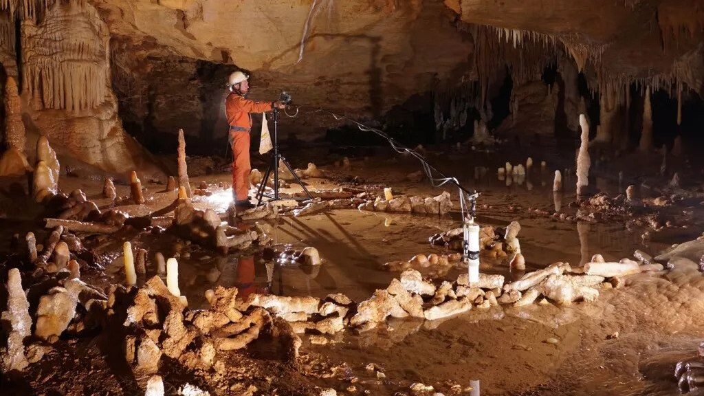
Deep in a Cave in France Neanderthals Constructed Mysterious Ring Structures 176,000 Years Ago
In February 1990, thanks to a 15-year-old boy named Bruno Kowalsczewski, footsteps echoed through the chambers of Bruniquel Cave for the first time in tens of thousands of years.
The cave sits in France’s scenic Aveyron Valley, but its entrance had long been sealed by an ancient rockslide. Kowalsczewski’s father had detected faint wisps of air emerging from the scree, and the boy spent three years clearing away the rubble. He eventually dug out a tight, thirty-meter-long passage that the thinnest members of the local caving club could squeeze through.
They found themselves in a large, roomy corridor. There were animal bones and signs of bear activity, but nothing recent. The floor was pockmarked with pools of water. The walls were punctuated by stalactites (the ones that hang down) and stalagmites (the ones that stick up).
Some 336 meters into the cave, the caver stumbled across something extraordinary—a vast chamber where several stalagmites had been deliberately broken. Most of the 400 pieces had been arranged into two rings—a large one between 4 and 7 meters across, and a smaller one just 2 meters wide. Others had been propped up against these donuts. Yet others had been stacked into four piles. Traces of fire were everywhere, and there was a mass of burnt bones.
These weren’t natural formations, and they weren’t the work of bears. They were built by people. Recognizing the site’s value, the caver brought in archaeologist Francois Rouzaud. Using carbon-dating, Rouzaud estimated that a burnt bear bone found within the chamber was 47,600 years old, which meant that the stalagmite rings were older than any known cave painting. It also meant that they couldn’t have been the work of Homo sapiens. Their builders must have been the only early humans in the south of France at the time: Neanderthals.
Scientists take measurements for the archaeo-magnetic survey in the Bruniquel Cave, where they found near-circular structures made of stalagmites.
The discovery suggested that Neanderthals were more sophisticated than anyone had given them credit for. They wielded fire, ventured deep underground, and shaped the subterranean rock into complex constructions. Perhaps they even carried out rituals; after all, there was no evidence that anyone actually lived in the cave, so what else were the rings and mounds for?
Rouzaud would never know. In April 1999, while guiding colleagues through a different cave, he suffered a fatal heart attack. With his death, work on the Bruniquel Cave ceased, and its incredible contents were neglected. They’ve only now re-entered the limelight because Sophie Verheyden went on holiday.
A life-long caver, Verheyden works at the Royal Belgian Institute of Natural Sciences, where she specializes in stalagmites. She treats them as time capsules, using the chemicals within them to reconstruct the climate of past millennia. So when she learned about Bruniquel Cave, while visiting the region on holiday and seeing a display at a nearby castle, she had only one thought: Why hadn’t anyone dated the broken stalagmites themselves?”
She knew that Rouzaud’s date of 47,600 years was impressive but suspect. Carbon dating is only accurate for samples younger than 50,000 years, so the Bruniquel material was hitting the technique’s limits. They could well have been much older. To get a better estimate, Verheyden assembled a team including archaeologist Jacques Jaubert and fellow stalagmite expert Dominique Genty. In 2013, they got permission to study the site and crawled into it themselves. “I’m not very big, and I had to put one arm before me and one behind to get through,” says Verheyden. “It’s kind of magical, even without the structures.”
After drilling into the stalagmites and pulling out cylinders of rock, the team could see an obvious transition between two layers. On one side were old minerals that were part of the original stalagmites; on the other were newer layers that had been laid down after the fragments were broken off by the cave’s former users. By measuring uranium levels on either side of the divide, the team could accurately tell when each stalagmite had been snapped off for construction.
Their date? 176,500 years ago, give or take a few millennia.
“When I announced the age to Jacques, he asked me to repeat it because it was so incredible,” says Verheyden. Outside Bruniquel Cave, the earliest, unambiguous human constructions are just 20,000 years old. Most of these are ruins—collapsed collections of mammoth bones and deer antlers. By comparison, the Bruniquel stalagmite rings are well-preserved and far more ancient.
And if Rouzaud’s work made it unlikely that modern humans built the rings, Verheyden’s study grinds that possibility into the dust. Neanderthals must have been responsible. There simply wasn’t any other hominin in that region at that time.
This 3D reconstruction reveals the stalagmite structures in the Bruniquel Cave in France.
Why did they build the rings and mounds? The structures weren’t foundations for huts; the chamber contains no stone tools, human bones, or any other sign of permanent occupation, and besides, why build shelter inside a cave? “A plausible explanation is that this was a meeting place for some type of ritual social behavior,” says Paola Villa from the University of Colorado Museum.
“When you see such a structure so far into the cave, you think of something cultural or religious, but that’s not proven,” adds Verheyden. Indeed, despite some fanciful speculations about cave bear cults, no one really knows.
Nor is it clear how the Neanderthals made the structures. Verheyden says it couldn’t have been one lone artisan, toiling away in the dark. Most likely, there was a team and a technically skilled one at that. They broke rocks deliberately and arranged them precisely. They used fire, too. More than 120 fragments have red and black streaks that aren’t found elsewhere in the chamber of the cave beyond.
They were the result of deliberately applied heat, at intensities strong enough to occasionally crack the rock. “The Neanderthal group responsible for these constructions had a level of social organization that was more complex than previously thought,” the team writes.
These discoveries are part of the Neanderthals’ ongoing rehabilitation. Since their discovery, scientists have tried to understand why they died out and we did not, with the implicit assumption that they were inferior in some important way. Indeed, to describe someone as a Neanderthal today is to accuse them of unsophisticated brutishness.
But we now know that Neanderthals made tools, used fire, made art, buried their dead, and perhaps even had language. “The new findings have ushered a transformation of the Neanderthal from a knuckle-dragging savage rightfully defeated in an evolutionary contest, to a distant cousin that holds clues to our identity,” wrote Lydia Pyne in Nautilus.
And now, we have Bruniquel Cave with its structures that are unprecedented in their complexity, antiquity, and depth within the darkness. We know that 400,000 years ago, some ancient hominins chucked their dead into a cave at Sima de Los Huesos, but there’s no evidence of the careful constructions in Bruniquel. There’s evidence of painting and sculpture within caves, but none older than 42,000 years. There are signs that Neanderthals used caves, but nothing to suggest that they frequently ventured deeper than sunlight.
“I think we have several lines of evidence showing that the cognitive abilities and behaviors of Neanderthals were complex,” says Marie Soressi from Leiden University. “But we had no direct evidence of their ability to build. That changes the picture for me. It’s puzzling to find such structures so deep inside the cave.”
To solve these puzzles, Verheyden wants to start cutting into the cave’s floor. It has been covered by layers of calcite, which may conceal specimens that hint at the chamber’s purpose. Verheyden also notes that the entrance they’ve been using cannot possibly have been the only one. “We’re crawling through this small thing and there are bear hollows in the cave. I don’t think the bears went in that way!” she says. “There must have been some other passage that collapsed.”
Hidden for 1,000 years-“Underground Great Wall” of China
The Song Dynasty (960AD-1127AD) battled for 200 years with the Liao and Jin Dynasties, which at the time were ruled by minorities of China’s Northern Territories, the Khitans, and Jurchens respectively.
The battleground was an endless flat ground, with no mountains or rivers that could be used to help defend against attack, but their secret was found more than half a century ago, when locals in the Yongqing village, Hebei, experienced a great flood.
Villagers were running for their lives when the course of the flood suddenly diverted and disaster was averted – exposing a series of underground passages spanning more than 300 square kilometers (115 square miles).
Experts in China discovered the Yongqing ancient war passages were widespread and formed part of a large-scale construction used to house troops during times of war.
The structure of the caves was complicated and possessed advanced military facilities such as camouflaged exits, covers, and locking gates. More recently though, the existence of a modern “underground Great Wall” tunnel network was unveiled in the mountainous regions of Hebei.
The labyrinthine tunnel system was built by the engineering unit of the Second Artillery in 1985 for concealing, mobilising and deploying China’s growing arsenal of nuclear weapons.
China has a serious of underground tunnels
The ancient tunnels were found half a century ago
Who Built the Ancient War Passages and When?
Experts discovered that the Yongqing ancient war passages were widespread. They were in fact a large-scale construction used to house troops during times of war.
The structures of the caves were complicated and complete, possessing military facilities such as camouflaged exits, covers, and locking gates. Facilities for housing people were also found, such as ventilation holes, lampstands, and heatable brick beds.
The “blue bricks” used in the construction of the passageways were 30×16×8 cubic centimeters in size. This kind of brick, created using fine soil baked at high temperatures, was very solid and robust; the use of such facilities suggests a well thought out and sophisticated underground network had been established at some point in time.
Military figures, Northern Song dynasty, 11th century, pottery, iron brown pigment and clear glaze, Lowe Art Museum.
Further investigation revealed that the blue bricks found in Yongqing County were the same as the bricks found in underground passages in Qigang, Xiong County from the Song Dynasty.
The creation and maintenance of such a massive underground network required a great number of these bricks. It is believed that these ancient war passages were constructed as part of a large nation-wide project created and overseen at a national level by the governing authorities of the time.
The Passages Spread Over 1,600 Square Kilometers
Experts have dug out similar war passages in Yongqing, Xiong county, and Bazhou. The ancient war passages are about 65 kilometers from east to west, 25 kilometers from north to south, which extend through 1,600 square kilometers.
When the border between the Song Dynasty and the Liao Dynasty went as far west as Rongcheng county and Xushui county, it is thought that many ancient war passages existed in that area. How far the ancient war passages extended eastwards from Yongqing is still unknown.
The tunnels were found in Hubei
Hiding Soldiers in the Ancient War Passages to Defend the Country
Amidst many legends about the underground network, one states that the ancient war passages were built by General Yang and his family; a family that produced three great generals over three generations.
Another legend suggests that General Yang Liulang used the underground passageways to defend the border. At the time (960-1127 AD), soldiers of the Liao Dynasty strictly guarded the lands north of Yongqing County. It is said that Yang Liulang built the passages to hide his soldiers underground so they could quickly defend against attacks launched by the Liao soldiers.
“Four Generals of Zhongxing” by Southern Song Dynasty artist Liu Songnian (1174–1224).
Experts point out that the underground passages may have been used as a base for launching attacks during wars fought in ancient China. As a means of defense throughout the years, people have built great walls in mountainous areas and water fields near rivers and lakes to block cavalries.
However, in the open plains, where it is difficult to use the terrain as a means of defense, the tunnels would have allowed soldiers to travel unseen below the earth.
The ancient war passages have become famous for the advantages they provide whether the troops are attacking or defending, and they have been named the “underground Great Wall.”
Similar tunnels are now used by the Chinese military