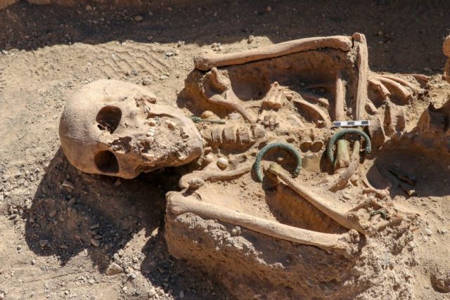
Urartian noblewoman buried with the jewelry found in the 2,750-year-old necropolis of Çavuştepe castle
Greek archaeologists have discovered a virtually intact grave of an ancient noblewoman buried with her golden jewellery at a Roman burial monument on the island of Sikinos.
Her name, according to a burial inscription, was Neko – or using the Greek alphabet.
The box-shaped grave was found untouched in the vault of the Episkopi monument, a rare burial memorial of the Roman era, which was later turned into a Byzantine church and a monastery.
Greek archaeologists have discovered a virtually intact grave of an ancient noblewoman buried with her golden jewellery at a Roman burial monument on the island of Sikinos. Her name, according to a burial inscription, was Neko
Golden wristbands, rings, a long golden necklace, a female figure carved cameo buckle, glass, and metal vases, and fragments of the dead woman’s clothes were found in the grave.
The well-preserved mausoleum on the tiny island, in the Cycladic group southeast of Athens, was likely to have been constructed to shelter the grave, archaeologists said.
‘We were unexpectedly lucky,’ Director of the Ephorate of Antiquities of Cyclades Dimitris Athanassoulis told Reuters on Monday. ‘This is Neko’s mausoleum.’
‘It’s very rare. A monument, one of the Aegean’s most impressive, has got an identity.
The box-shaped grave was found untouched in the vault of the Episkopi monument, a rare burial memorial of the Roman era, which was later turned into a Byzantine church and a monastery
‘We now have the person for whom the building was built, we have her remains, her name.’
Despite attacks by grave robbers in ancient times and the building’s various uses through the centuries, Neko’s grave was found intact mainly because it was well hidden in a blind spot between two walls in the basement of the building, Athanassoulis said.
He said that experts thought Neko had links to the island but it was not clear whether she was actually from Sikinos.
‘We are now trying to find out more about her,’ he said. ‘We are still at the beginning.’
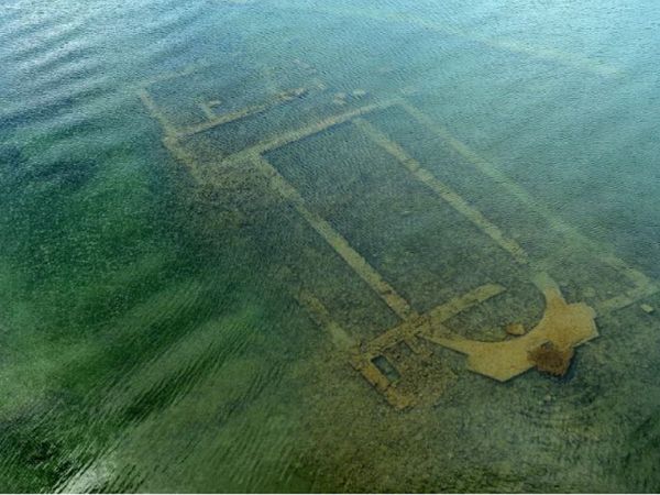
A 1,600-year-old basilica re-emerged due to the withdrawal of waters from lake iznik
The 1600-year-old basilica found under Lake Iznik in crystal clear water shows breathtaking aerial images. Archeologists, and art historians believe that after an earthquake in 740, the religious structure collapsed during an earthquake in 740, before sinking further into the lake.
The underwater building lies between 1.5 and 2 meters below the sea and can be clearly seen for the first time, as the coronavirus lockdown has resulted in less water pollution.
The local authority recently flew a drone over the site to take stunning images, revealing the basilica’s walls and structure just below the lake surface.
In 2014, when it was first found by experts, the Archaeological Institute of America named the basilica as one of the top 10 discoveries of the year. It was discovered while photographing the area from the air for an inventory of historic sites and cultural artifacts.
Five years ago the Doğan News Agency reported that the submerged structure was set to become an underwater museum. Experts believe it was built in AD 390, to honor St. Neophytos, who was among the saints and devout Christians martyred during the time of Roman emperors Diocletian and Galerius.
Neophytos was killed by Roman soldiers in A.D. 303, a decade before an official proclamation permanently established religious toleration for Christianity within the Roman Empire, they say.
I thought to myself, ‘How did nobody notice these ruins before?’ said Prof Mustafa Sahin
Uludag University Head of Archaeology Department Prof Mustafa Sahin told the agency in 2015 the church was built in tribute to him, at the place that he was killed.
He said: “We think that the church was built in the 4th century or a later date.
“It is interesting that we have engravings from the Middle Ages depicting this killing. We see Neophytos being killed on the lake coast.” Ancient resources show that Christians definitely stopped by Iznik in the Middle Ages while making their pilgrimage to visit the church.
“Rumour has it that people in Iznik were asking for help from the body of Neophytos when they were in difficulty,” Sahin said.
The researcher told Live Science that he been carrying out field surveys in Iznik since 2006, and “I hadn’t discovered such a magnificent structure like that.
“When I first saw the images of the lake, I was quite surprised to see a church structure that clearly.”
He also told the Archaeological Institute of America: “I did not believe my eyes when I saw it under the helicopter.
“I thought to myself, ‘How did nobody notice these ruins before?’”
PAGAN TEMPLE?
And, there might be a pagan temple beneath the church, reports The Weather Channel. Researchers have uncovered fragments of an ancient lamp and early coins from the reign of the emperor Antoninus Pius – indicating a more historic structure buried under the church.
Early coins found at the submerged basilica
Sahin said he believed the basilica could have been built on top of a temple to Apollo. The information shows there is a connection with the Roman emperor Commodus – to a similar temple at Iznik, then known as Nicea, outside city walls.
“Could this temple have been underneath the basilica remains?” Sahin asked of the church, which is to be transformed into an underwater archaeological museum.
The early Byzantine-era basilica has architectural elements from the early period of Christianity and is situated 20 meters from the banks of Lake Iznik in the north-western Turkish province of Bursa.
Archaeological finds excavated since 2015 include the memorial stamp of the Scottish knights, who were believed to have been among the first foreign visitors to the basilica, reports Daily Sabah.
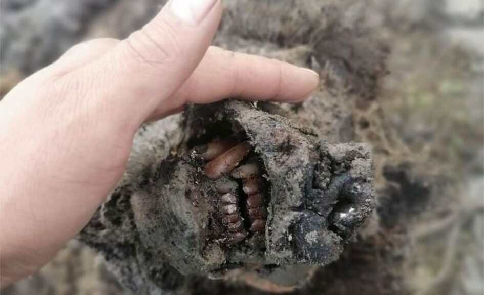
World-first Perfectly Preserved Ice age bear found in Russia
In the Russian Arctic, the fully preserved remains of an Ice Age cave bear were discovered – the first specimen of the animal that has ever been identified with soft tissues.
The remarkable discovery was found in the Lyakhovsky Islands in the Far North of Russia Part of the Modern Siberian Islands, find was made by reindeer herders
Previously only the bones of the cave bears had been found, but this specimen even had its nose intact, according to a team of scientists from the North-Eastern Federal University (NEFU) in Yakutsk, Siberia.
A head of an Ice Age cave bear found on Bolshoy Lyakhovsky Island, or Great Lyakhovsky, the largest of the Lyakhovsky Islands belonging to the New Siberian Islands archipelago between the Laptev Sea and the East Siberian Sea in northern Russia. Reindeer herders in a Russian Arctic archipelago have found an immaculately preserved carcass of an Ice Age cave bear revealed by the melting permafrost, which has all its internal organs, teeth, and even its nose intact.
The discovery is of “world importance,” a leading Russian expert on extinct Ice Age species said.
In a statement released by the university, scientist Lena Grigorieva said: “Today this is the first and only find of its kind — a whole bear carcass with soft tissues. It is completely preserved, with all internal organs in place including even its nose.
The Ice Age-era bear was found on the Lyakhovsky Islands in north-east Russia
“Previously, only skulls and bones were found. This find is of great importance for the whole world.”
The adult animal was found by a group of reindeer herders, who then transferred the right to research the specimen to the NEFU, which is at the forefront of research into extinct woolly mammoths and rhinos.
According to the team, the cave bear (Ursus spelaeus) is a prehistoric species or sub-species that lived in Eurasia in the Middle and Late Pleistocene period and became extinct some 15,000 years ago. Preliminary analysis suggests the bear is between 22,000 and 39,500 years old.
Maxim Cheprasov, the senior researcher from the Mammoth Museum laboratory in Yakutsk, said in the statement: “It is necessary to carry out radiocarbon analysis to determine the precise age of the bear.”
Scientists have not yet been able to visit the site of the discovery — the ancient carcass was found a long way from Yakutsk, which itself is more than 5,000 miles from Moscow.
Significant discoveries, including mammoths, woolly rhinos, Ice Age foal, several puppies, and cave lion cubs, have been made in Siberia in recent years as the permafrost melts.
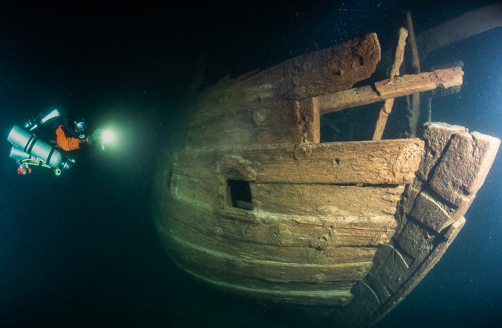
A well-preserved 400-year old ship has been found in the Baltic Sea
Although the company reported wrecks of some so-called 1st or 2nd World War wrecks at the mouth of the Gulf of Finland, Badewanne divers descended on one of the biggest surprises during their long career of diving the wrecks of this eastern extension of the Baltic Sea.
The Baltic Sea has been an exceedingly important trading itinerary since the Middle Ages, as the navies of Holland and England needed endless supplies of wood, tar, and hemp, all of which were available around the Baltic.
The Hanseatic League dominated the trade from the 13th century but the highly powerful merchant fleet of the Dutch Republic acquired dominance of the trade during the 17th century.
Port side hull view of the stern of the wreck. Decorated stern cabin window holes are visible.
This trade received a significant boost in importance and profitability after Czar Peter the Great founded his new capital St. Petersburg at the estuary of Neva river, in the easternmost part of GoF.
One ship type rises above others and becomes the mainstay of this trade: the Dutch “Fluit” ship, a three-masted ship with very capacious hull design, carrying no guns, and allowing a very large cargo capacity.
In addition, the Fluit ships utilized a very novel and advanced rigging using cleverly designed pulley and tackle systems for hoisting the yards and sails and controlling them.
These advanced technical features facilitated a much smaller crew than earlier ship types, making the trade more profitable. Another totally novel feature onboard the Fluit ships were that the entire crew lived “abaft of the mainmast” – Master, mates, bosun, cook, and all ratings, all occupied the same space ‘tween decks and ate at the same table.
This was very unusual in contemporary society, let alone in the highly hierarchic maritime world. Fluit ships were dominant in the Baltic trade between the late 16th to the mid-18th centuries. However, very few of these once common ships have survived, even as wrecks.
Therefore, it was to our great surprise when descending on a wreck at 85 meters depth, expecting to see an early WW1 minesweeper or a schooner sunk during WW2, we realized that we are looking at an almost completely preserved Dutch Fluit ship! She rests on even keel on the seabed, with most of her rigging scattered around her.
There is only slight damage from a pelagic trawl. The trawl seems to have swept her from a bow towards the aft, dislocating the stem, damaging the poop deck, and the topmost part of the typical Fluit transom somewhat.
Apart from these damages, the wreck is intact, holds are full, and all side planking is firmly in place. Even the damaged parts and components of the transom decorations, such as the “Hoekmen”, or the “Strongmen” may be found on the bottom behind the stern. Luckily, only very small bits of the trawl netting remain on the wreck.
Anchor windlass in the bow, viewed from the starboard side.
It is only in rare places around the world, including the Baltic Sea, where wooden wrecks can survive for centuries without being destroyed by chemical, biochemical and biological decaying processes.
Due to low salinity, absolute darkness, and very low temperatures all year round these processes are very slow in the Baltic. Perhaps most importantly, wood-boring organisms such as shipworm cannot live in such an environment. Even in temperate seas, all wooden wrecks vanish in decades, unless buried in sediments.
This find, a practically intact and complete Dutch Fluit ship, the Queen of the Baltic trade from almost 400 years back, is a good example of the importance of the Baltic Sea, and especially the Gulf of Finland as a special cellar of the sea.
Only here the environment preserves the wrecks, which are plentiful due to the sea being a very important trade route and battleground for many wars during centuries.
And all of these wrecks are within the range of modern technical diving methods! Badewanne team will continue documenting and investigating this significant wreck in co-operation with the Finnish Heritage Agency of Antiquities and other partners, Including Associate Professor Dr. Niklas Eriksson, Maritime Archaeologist, Univ. of Stockholm, Sweden:
“The wreck reveals many of the characteristics of the fluit but also some unique features, not least the construction of the stern. It might be that this is an early example of the design. The wreck thus offers a unique opportunity to investigate the development of a ship type that sailed all over the world and became the tool that laid the foundation for early modern globalization,” says Dr. Eriksson.
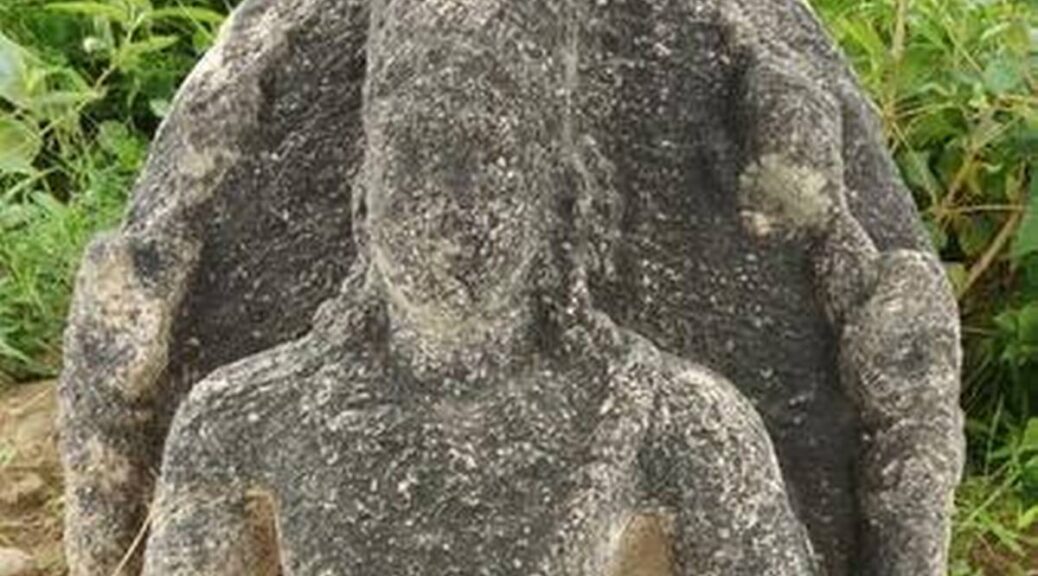
1,200-Year-Old Sculpture Unearthed in Southern India
The Hindu reports that an eighth-century A.D. sculpture of Lord Vishnu, one of the principal Hindu deities.
M. Maruthu Pandiyan of the Madurai Government Museum said the style of the sculpture corresponds to the Pandya dynasty, a Tamil-speaking group that ruled in South India and Sri Lanka as early as the fourth century B.C.
An eight century Common Era (CE) sculpture of Lord Vishnu, belonging to the Pandya period, was found at the western bank of the Gundaru river at Ulagani village of Kallikudi block in southern India by a team of researchers from Madurai Kamaraj University.
Madurai Government Museum Curator M. Maruthu Pandiyan and Udhayakumar, a researcher, checked the sculpture based on the information provided by Kannan, a Tamil student of a college affiliated to Madurai Kamaraj University, and Sangaiah, a professor from the college.
Mr. Maruthu Pandiyan said the features of the sculpture indicated that it belongs to the Pandya period. “Mainly, the sacred thread of the sculpture goes above the right forearm and a broad ‘kanthi’ (necklet) studded with big gems adorns the neck.
Similar sculptures of the Pandya period have been found in various places such as Thirumalapuram, Tirupparankundram, and Sevalpatti,” he said.
The sculpture has four hands. Among them, two arms are held up vertically. The right arm has a broken chakra and in the left arm a conch. “The chakra and conch are the main features of the Pandya period,” said Mr. Maruthu Pandiyan.
An eight century Common Era (CE) sculpture of Lord Vishnu, belonging to the Pandya period, was found at the western bank of the Gundaru river at Ulagani village of Kallikudi block in Madurai.
The village has also been mentioned in a book about the inscriptions of the Madurai district, which was released by the State Archaeology Department.
The book mentions that this village had an old name, ‘Kulasegara chathurvethimangalam or Ulagunimangalam.”
Also, a 13th-century Pandya inscription mentioned that the local village administrators had levied a special tax called ‘pasipaattam’ tax (a tax on fishing) for the renovation of the tank.
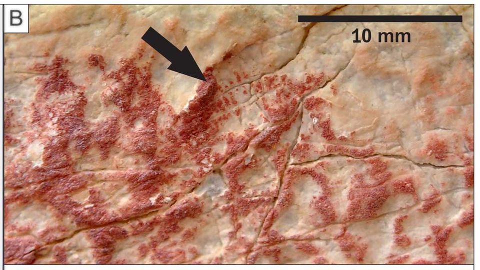
Two fingerprints discovered in rock art at the Los Macho Rock Shelter in Spain indicate a man who was at least 36 years old and a girl between the ages of ten and 16, according to a report in The Art Newspaper.
Not only are fingerprints effective in the identification and unlocking of your phone, but they also can help to learn about ancient artists too.
Researchers recently analyzed 2 fingerprints discovered between the painted rock art in Los Macho’s rock shelter, in southern Spain, according to a new study published in the journal Antiquity.
The work done by a team of researchers from the University of Granada, the University of Durham, and the Autonomous University of Barcelona, shines a rare light on the artists who produced Spain’s rock art and the society in which they lived.,
Created between 4,500 and 2,000 BC and painted by finger, the prehistoric “schematic art” involves strokes, circles, geometric motifs, and human figures, and “probably relate to daily life, and are the materialization of symbolic elements understood by the communities that inhabited the area around Los Machos” at the time, the team writes in Antiquity.
“The true value of rock art lies in how it represents the direct expression of the thought processes of the people who created it. These individuals are very often missing from discussions of rock art sites.”
“The analysis of fingerprints in terms of sex and age is a great contribution towards understanding who was involved in the production of rock art,” says Leonardo García Sanjuán, a professor in prehistory at the University of Seville.
“For example, a gender analysis of rock art would be possible if sufficient amounts of evidence on fingerprints like that presented in this paper were compiled: was rock art made by children, adults, women and men alike? Or were there specific age and sex groups in charge of its production? Up until now, we knew next to nothing about these issues.”
A prehistoric fingerprint, or palaeodermatoglyph, spotted on the rock art
Scholars are able to determine a person’s sex and age using fingerprints on archaeological remains because the characteristics of the prints differ.
Men tend to have broader fingerprint ridges than women, for example, while the distance between ridges grows from childhood to adulthood, helping to deduce age.
Prehistoric archaeologist Margarita Diaz-Andreu, an ICREA Research Professor based at the University of Barcelona, says that the study is an “exciting proposal,” but urges some caution.
“We know that in several societies in the world, the people who were in charge of painting were often accompanied by other members of the community. This means that the fingerprints may not have come from the authors of the paintings.”
Although prehistoric rock art has been extensively studied, few facts have been gleaned about the artists who created these works.
It was once assumed that the much earlier rock art of the Upper Palaeolithic era (at least 20,000 years ago) was mainly produced by men because the artists often painted animals that would have been hunted.
Today though, analyses of the hand stencils left by these Palaeolithic artists have shown that men, women, and children all played a role in producing the works. In fact, one study of rock art in various French and Spanish caves showed that 75% of the hand stencils were female.
In a similar way, fingerprint analysis can help researchers to challenge assumptions about prehistoric artists.
“The research into authorship, using the methodology applied here, could reveal further complex social dimensions at other rock art sites worldwide,” writes the research team.
A 15-year-old school student from Quebec, Canada, William Gadoury discovered something that archaeologists have been covering for centuries-a nearly abandoned Mayan civilization settlement, hidden deep within the Yucatan jungle of Southeastern Mexico.
Gadoury has named the newly discovered Mayan metropolis K’aak Chi, after reading about their 2012 apocalypse prediction.
He didn’t do it by hiring a bunch of expensive equipment, hopping on a plane, and slaving away on an excavation site – he discovered the incredible ruins from the comfort of his own home, by figuring out that the ancient cities were built in alignment with the stars above.
“I did not understand why the Maya built their cities away from rivers, on marginal lands and in the mountains,” Gadoury told French-Canadian magazine, Journal de Montréal.
“They had to have another reason, and as they worshipped the stars, the idea came to me to verify my hypothesis. I was really surprised and excited when I realised that the most brilliant stars of the constellations matched the largest Maya cities.”
Gadoury had been studying 22 Maya constellations for years before releasing that he could line up the positions of 117 Maya cities on the ground with maps of stars and constellations above – something that no one had pieced together before.
With this in mind, he located a 23rd constellation, which included just three stars. According to his sky map, he could only link up two cities with the three stars, so suspected that a third city remained undetected in that spot.
Satellite images compared with Google Earth show potentially man-made structures beneath the jungle canopy.
Unfortunately, the location on the ground that matched up with the third star wasn’t exactly somewhere that Gadoury could just go visit – it’s right in the heart of the jungle, in the inaccessible and remote region of Mexico’s southern Yucatán Peninsula.
Not that stopped Gadoury – he knew that a fire had stripped much of the forest in the area back in 2005, which meant that from above, you might have an easier time spotting ancient ruins than if the canopy had been thriving for the past couple of thousand years.
All he needed to do was access satellite imagery of the area from the Canadian Space Agency, which he mapped onto Google Earth images to see if there were any signs of his lost city.
Further analyses from satellites belonging to NASA and the Japanese Space Agency revealed what looks like a pyramid and 30 buildings at the location mapped by the star, Yucatan Expat Life reports.
William Gadoury, 15, explains his theory of the existence of a Mayan city still unknown in Mexico before scientists at the Canadian Space Agency.
As Daniel De Lisle from the Canadian Space Agency told Samuel Osborne at The Independent, the satellite images revealed certain linear features on the forest floor that looked anything but natural. “There are enough items to suggest it could be a man-made structure,” he said.
Gadoury has tentatively named the lost city K’àak’ Chi’, meaning “fire mouth”, and will be working with researchers from the Canadian Space Agency to get his discovery published in a peer-reviewed journal.
Now, we don’t want to burst anyone’s bubble here, but while things look promising from those satellite images, nothing can be confirmed until experts can access the site and see the remains up close.
A team of archaeologists is now figuring out how to make that happen, and one of the researchers involved in the project, Armand LaRocque from the University of New Brunswick, told the Journal de Montréal that if they can get the funds to organise an excavation, they’ll be taking Gadoury along for sure.
“It would be the culmination of my three years of work and the dream of my life,” said Gadoury, and suddenly we feel incredibly inadequate that the best thing we did at 15 was hand in most of our assignments on time.
Update: In a strange development, a scientist familiar with the Mexican region where the odd, city-like features have been discovered says at least one of them is either an abandoned cornfield – or a covert marijuana operation.
“We’ve visited them, and my grad students know them quite well,” anthropologist Geoffrey E. Braswell from the University of California San Diego’s Mesoamerican Archaeology Laboratory told George Dvorsky at Gizmodo. “They’re not Maya pyramids.”
No word yet on what this means for Armand LaRocque’s planned expedition to the site, but things aren’t looking good for Gadoury’s science fair entry at this stage. But Braswell has praised his curiosity and told The Washinton Post he hopes he ends up at his university to study.
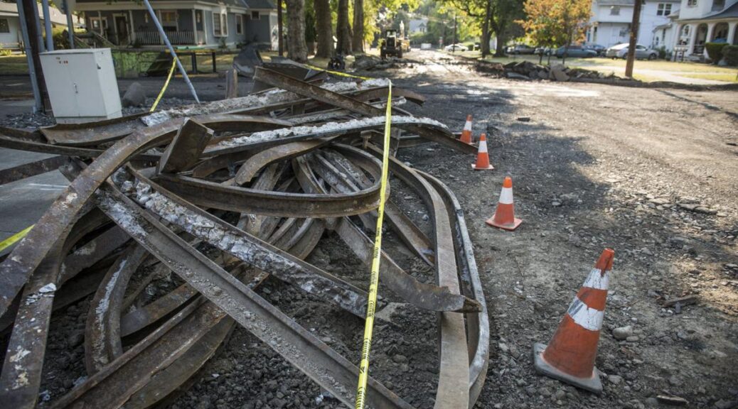
Early 20th-Century Trolley Tracks Found in Washington State
Contractors dug up history last week when rails from Walla Walla’s trolley system dating back to 1906 were removed from Whitman Street between First and Second avenues.
The tracks once connected Walla Walla residents to downtown, Pioneer Park, the Walla Walla County Fairgrounds, cemetery, and many other key stops before automobiles became the common transportation mode.
For 5 cents, Walla Wallan’s could take a trip around the city’s central portion, and as far as Pleasant Street or Prospects Heights. Stops included colleges, local businesses and an opera house.
About 450 linear feet of those trolley tracks were dug up to replace the sewer main underneath them as part of the Third and Maple Infrastructure Repair and Replacement Plan Project, including water, sewer and road improvements expected to be complete in October, city officials said Tuesday.
The removal of trolley tracks is permitted because of measures taken to mitigate the impact of the loss of the tracks. These efforts included hiring Fort Walla Walla Musem to conduct an archeological survey, research and report on the trolley system in 2011 when a different project called for the removal of the tracks.
Other efforts included interpretative signage placed along the former trolley line near Sharpstein School and at modern bus stops on the former trolley line, a Powerpoint presentation on the trolley system used for public education purposes and a publication of an article.
When part of the rail was removed in 2011, archeologists took a piece of it. The rail had a date on it and listed the manufacturer, confirming the research, said Mike Laughery, the city’s capital programs engineer.
That piece is at Fort Walla Walla Museum and if needed, can be curated, made part of the museum, and put on display.
With these steps, the state Department of Archaeology and Historic Preservation and the Confederated Tribes of the Umatilla Indian Reservation continue to grant permission for removal of the tracks for each infrastructure project the city plans, so far, Laughery said.
Another step in honoring the history could be incorporating a segment of railroad tracks into the design, Laughery said. That would mean removing the original tracks, rebuilding the utilities, and then setting the new tracks back in the roadway, so they are still visibly present, he said.
That idea has not yet been required, he said.
According to the 2011 report, exposed trolley tracks create safety hazards for pedestrians and cyclists. Leaving tracks beneath asphalt leads to premature failure of that street surface, and pavement failure associated with the tracks was discovered in various locations where buried rails exist.
Some of the trolley tracks remained much longer than they were in use, and portions can still be seen on Whitman Street between Howard and Division streets, near the intersection of Clinton and Boyer streets and along North Sixth Avenue to Cherry Street. The trolley only operated 20 years before the automobile became so common that the line had to close down in 1926.
“I don’t know what the financial investment was back then but it had to have been substantial,” Laughery said. “I don’t know if they just didn’t foresee the development of the automobile or how that played out.”
Trolley cars would hold 28 to 72 passengers and were equipped with onboard electric motors. Overhead wires supplied electricity to the cars through metal rods extending from the roof, according to an article published by Maury Mule of the Fort Walla Walla Museum.
The trolley cars had two-piece windows allowing for air during hot summer days and maintaining heat in the colder months with an onboard coal-fired stove providing heat to the car, the article stated.
The trolley operated in conjunction with an interurban line, which closed in 1931 and ran about 13 miles south to the Oregon cities of Milton and Freewater, the article stated. Spur lines and connections to national rail networks would appear.
No other discoveries were reported when the contractors removed the tracks, Laughery said. Project contractor Total Site Services now owns the tracks, and if no one wants them, they will probably be scrapped, according to city staff.
For further information, call the city’s Engineering Division at 509-527-4537.