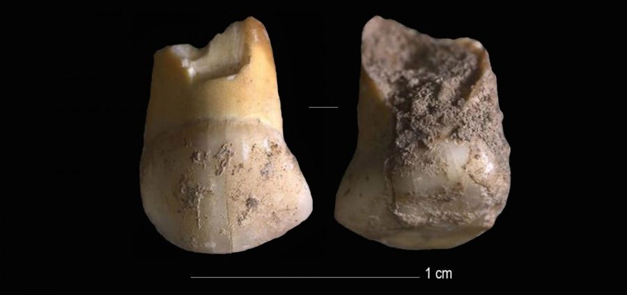
A 48,000 years old tooth that belonged to one of the last Neanderthals in Northern Italy
A milk tooth belonging to one of Italy’s last Neanderthal children has been found near Venice. The canine tooth belonged to a pre-teen, likely 11 or 12 years old, and dates back 45,000 years.
Neanderthals went extinct around 40,000 years ago after being out-competed for food and shelter by the more intelligent Homo sapiens. The tooth would have been in the upper row of teeth on the right-hand side of the child’s mouth.
It was discovered in a rock shelter at an archaeological site called ‘Riparo del Broion’ on the Berici Hills in the Veneto region, near Venice. The tooth is the first-ever human remain to be found at the site.
Genetic analysis of mitochondrial DNA preserved inside the tooth, as well as analysis of the enamel and shape, reveal it is from a Neanderthal and not a Homo sapien.
Matteo Romandini, lead author of the study at the University of Bologna says: ‘High-resolution prehistoric field-archaeology allowed us to find the tooth, then we employed virtual approaches to the analyses of its shape, genome, taphonomy and of its radiometric profile.
An upper canine milk-tooth (pictured) that belonged to a Neanderthal child, aged 11 or 12, that lived between 48,000 and 45,000 years ago was found in Northern Italy
Neanderthals (pictured, artist’s impression) went extinct around 40,000 years ago after millennia of struggling to compete with the superior intelligence of Homo sapiens which had recently arrived in Europe.
‘Following this process, we could identify this tooth as belonging to a child that was one of the last Neanderthals in Italy.’
Mitochondrial DNA is similar to normal DNA, except it is smaller and stored in the mitochondria, the powerhouses of human cells, not the nucleus.
The milk tooth was discovered in a rock shelter at an archaeological site called ‘Riparo del Broion’ on the Berici Hills in the Veneto region, near Venice. The tooth is the first-ever human remain to be found at the site
It is also inherited only from the mother and therefore paints a picture of maternal heredity. The owner of this tooth had a mother who was descended from Neanderthals that had lived in Belgium, the DNA revealed.
‘This small tooth is extremely important’, says Stefano Benazzi, professor at the University of Bologna and research coordinator.
‘This is even more relevant if we consider that, when this child who lived in Veneto lost their tooth, Homo Sapiens communities were already present a thousand kilometers away in Bulgaria’.
The early findings are published in the Journal of Human Evolution and researchers are still delving through the other findings the archaeological site has revealed.
For example, there are many signs of hunting and that the site was used to butcher large animals.
‘The manufacturing of tools, mainly made of flint, shows Neanderthals’ great adaptability and their systematic and specialized exploitation of the raw materials available in this area’, adds Marco Peresanti, a professor of the University of Ferrara who contributed to the study.
Neanderthals first arrived in Europe around 350,000 years ago and lived without rivals until around 45,000 years ago, when Homo sapiens first ventured into Eurasia.
When Homo sapiens — modern humans — moved into Europe they hunted the same animals and sought the same plants to survive a Neanderthals.
This proximity led to mingling and even interbreeding, Neanderthal DNA can be found in modern-day humans to this day.
It is believed the two species managed to co-exist for around 8,000 years, but the competition over limited resources led Neanderthals to extinction at some point between 43 to 38 thousand years ago.
A map showing the relative dates at which humans arrived in different Continents, including Europe 45,000 years ago. Humans and Neanderthals co-existed for about 8,000 years before Neanderthals went extinct
100-million-year old giant sperm found trapped in amber
The world’s oldest animal sperm has been found in a tiny crustacean trapped in Amber about 100 million years ago in Myanmar by the international partnership of researchers from London’s Queen Mary University and the Chinese Academy of Science in Nanjing.
Dr. He Wang of the Chinese Academy of Science in Nanjing led the study team to locate sperm in a new species called Myanmarcypris hui. They predict that the animals had sex just before their entrapment in the piece of amber (tree resin), which formed in the Cretaceous period.
Sperm fossilized was exceptionally rare; previously the oldest known examples were only 17 million years old. Myanmarcypris hui is an ostracod, a kind of crustacean that has existed for 500 million years and lives in all kinds of aquatic environments from deep oceans to lakes and rivers.
One of the ostracods trapped in amber.
Their fossil shells are common and abundant but finding specimens preserved in ancient amber with their appendages and internal organs intact provides a rare and exciting opportunity to learn more about their evolution.
Professor Dave Horne, Professor of Micropalaeontology at Queen Mary University of London said: “Analyses of fossil ostracod shells are hugely informative about past environments and climates, as well as shedding light on evolutionary puzzles, but exceptional occurrences of fossilized soft parts like this result in remarkable advances in our understanding.”
Besides a few insects, 39 ostracod crustaceans were entrapped in this tiny piece of Cretaceous amber found in Myanmar, including one containing the world’s oldest sperm cells.
During the Cretaceous period in what is now Myanmar, the ostracods were probably living in a coastal lagoon fringed by trees where they became trapped in a blob of tree resin.
The Kachin amber of Myanmar has previously yielded outstanding finds including frogs, snakes, and a feathered dinosaur tail. Bo Wang, also of the Chinese Academy of Science in Nanjing added: “Hundreds of new species have been described in the past five years, and many of them have made evolutionary biologists re-consider long-standing hypotheses on how certain lineages developed and how ecological relationships evolved.”
The study, published in Royal Society Proceedings B, also has implications for understanding the evolutionary history of an unusual mode of sexual reproduction involving “giant sperm.”
The new ostracod finds may be extremely small but in one sense they are giants. Males of most animals (including humans) typically produce tens of millions of really small sperm in very large quantities, but there are exceptions.
Some tiny fruit flies (insects) and ostracods (crustaceans) are famous for investing in quality rather than quantity: relatively small numbers of “giant” sperm that are many times longer than the animal itself, a by-product of evolutionary competition for reproductive success.
The new discovery is not only by far the oldest example of fossil sperm ever found but also shows that these ostracods had already evolved giant sperm, and specially-adapted organs to transfer them from male to female, 100 million years ago.
Each ostracod is less than a millimeter long. Using X-ray microscopy the team made computer-aided 3-D reconstructions of the ostracods embedded in the amber, revealing incredible detail.
A 3D reconstruction of the female ostracod.
Artist’s reconstruction of the Cretaceous ostracod crustacean Myanmarcypris hui male (right) and female (left) during mating.
“The results were amazing — not only did we find their tiny appendages to be preserved inside their shells, but we could also see their reproductive organs,” added He Wang. “But when we identified the sperm inside the female and knowing the age of the amber, it was one of those special Eureka-moments in a researcher’s life.”
Wang’s team found adult males and females but it was a female specimen that contained the sperm, indicating that it must have had sex shortly before becoming trapped in the amber.
The reconstructions also revealed the distinctive muscular sperm pumps and penises (two of each) that male ostracods use to inseminate the females, who store them in bag-like receptacles until eggs are ready to be fertilized.
Such extensive adaptation raises the question of whether reproduction with giant sperms can be an evolutionarily-stable character. “To show that using giant sperms in reproduction is not an extinction-doomed extravagance of evolution, but a serious long-term advantage for the survival of a species, we need to know when they first appeared,” says co-author Dr. Renate Matzke-Karasz of Ludwig-Maximilians-University in Munich.
This new evidence of the persistence of reproduction with giant sperm for a hundred million years shows it to be a highly successful reproductive strategy that evolved only once in this group — quite impressive for a trait that demands such a substantial investment from both males and females, especially when you consider that many ostracods can reproduce asexually, without needing males at all.
“Sexual reproduction with giant sperm must be very advantageous,” says Matzke-Karasz.
The Prairies are home to tons of hidden treasures, some of which are hiding right under our noses. Even though this lake is super popular and is located in a huge national park, few could ever guess a ghost town lies just beneath the waters.
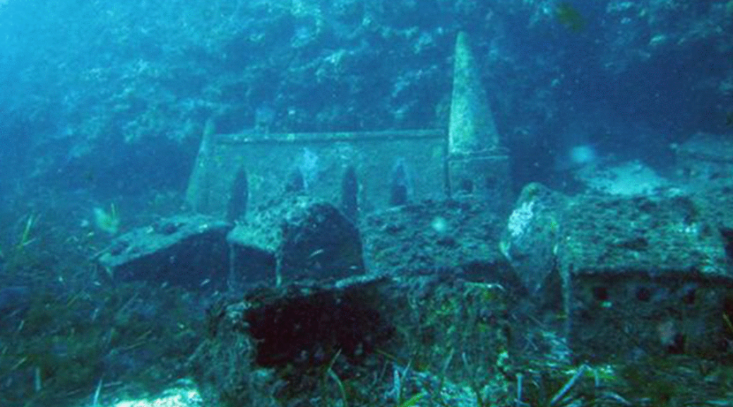
The sunken city under Lake Minnewanka is a hidden treasure that few have seen and it’s waiting to be discovered.
Deep below the surface of the lake’s pristine waters is the sunken resort town of Minnewanka Landing. While it used to bustle with tourism and life, according to Parks Canada, its only residents are now trout and the occasional scuba diver.
Beneath the surface of Lake Minnewanka, located in Alberta, Canada, rests the remains of a former resort town.
The village was built way back in 1888 when the water levels were much lower. Soon, cottages sprung up, restaurants and hotels were built, and even a boat tour started ferrying travellers around the scenic lake. For a little while, life was great at Minnewanka Landing.
Over the years the town grew to include four avenues, three streets, dozens of cottages, numerous hotels and restaurants, and multiple sailing outfits that would take guests on boat excursions around the (much smaller) original lake.
It wouldn’t be until 1912 that the area’s landscape would start to evolve with the construction of a new dam—part of a Calgary Power Co. hydroelectric plant operation being set up downriver—resulting in the flooding of a good portion of Minnewanka Landing.
But while the town continued to thrive over the next two decades (42 lots were built to make way for additional cabin sites), it would finally meet its fate in 1941 with the building of a new dam, which raised the reservoir’s waters by 98 feet, engulfing everything in its wake.
“It was during the Second World War and everyone was hungry for power,” Bill Perry, an archeologist with Parks Canada, tells Smithsonian.com. “Calgary and the surrounding area were growing substantially during that point in time and required more power, so Lake Minnewanka was seen as an easy end.”
Today the reservoir hides a secret that many people will never get the chance to experience—unless they’re scuba divers, that is. Thanks to Lake Minnewanka’s glacier-fed, ice-cold waters, many structures of the former resort town still remain intact, including house and hotel foundations, wharves, an oven, a chimney, a cellar, bridge pilings, and sidewalks. (A full list of sites is available here.) Even the footings from the town’s original dam, built by the federal government in 1895, along with the footings from the dam built in 1912, remain visible.
Another notable site nearby is a native campsite that dates back thousands of years.
In recent years, archaeologists have uncovered spear points, arrowheads, ancient weapons known as atlatls, stone tools, and other implements used by indigenous tribes who once lived there.
“What is particularly interesting about that for me is looking at the whole area as a cultural landscape,” Perry says. “The area’s 13,000 years of continuous use absolutely fascinates me.”
And Perry isn’t alone. He estimates that approximately 8,000 divers descend into the lake each year to explore its hidden past.
“Because of the cold, clear water, wood actually survives quite well down there,” he says. “That’s why it has become such a popular diving place for local scuba diving clubs. There’s just so much left to see.”
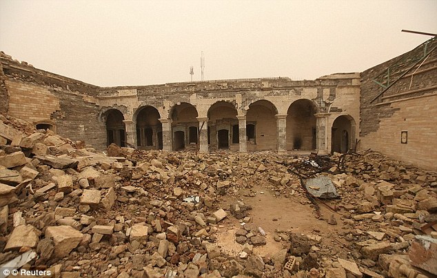
The 2,600-Year-old palace is found buried under the ruins of a shrine blown up by Isis in Mosul
Archaeologists assessing the damage caused by Islamic State militants to the tomb of the prophet of Jonah have made a surprise discovery. Experts found a previously untouched palace dating back to 600BC buried under the ruins of Jonah’s desecrated resting place.
The Nebi Yunus shrine – containing what Muslims and Christians believe to be the tomb of Jonah or ‘Yunnus’ as he is known in the Koran – was destroyed by ISIS militants in July 2014.
Weeks after overrunning Mosul and much of Iraq’s Sunni Arab heartland, ISIS militants rigged the shrine and blew it up, sparking global outrage. ISIS militants believe giving special veneration to tombs and relics is against the teachings of Islam.
Archaeologists assessing the damage caused by Islamic State militants to the tomb of the prophet of Jonah have found an undiscovered palace. Here, a member of the Iraqi army stands next to Assyrian stone sculptures of demi-goddesses, pictured spreading the ‘water of life’
The shrine holding Jonah’s tomb is located on top of a hill in eastern Mosul, a city in northern Iraq with a population of around 660,000 that was retaken from ISIS control by Iraqi army forces last month.
Archaeologists have been picking through ancient rubble left behind by the terror group as they attempt to salvage surviving artefacts. They told the Telegraph that ISIS dug tunnels deep under the shrine and into a previously undiscovered and untouched palace dating back to 600BC. These tunnels were not professionally built, leaving them unstable and at risk of collapse within the next few weeks, burying the ancient palace.
‘We fear it could all collapse at any time,’ entombing the treasures, said archaeologist Layla Salih, who is in charge of antiquities for the Nineveh province where the shrine stands.
The impressive maze of tunnels dug by the jihadists to carry out excavations is located in the heart of the hill that houses the tomb of the Prophet Jonah. These demi-goddess sculptures were carved into the walls over 2,000 years ago
‘There are cave-ins in the tunnels every day.’
It had long been rumoured that the shrine shared a site with an ancient palace. Excavations had previously been carried out by the Ottoman governor of Mosul in 1852. The Iraqi Department of antiques also studied the site in the 1950s.
But neither excavation had dug as far as the ISIS militants, leaving the palace undiscovered for 2,600 years. The finding is the first example of ISIS militants tunnelling underneath historic sites to find artefacts to loot. Within one of the ISIS tunnels, archaeologists found a marble inscription of King Esarhaddon, thought to date back to the Assyrian empire in 672BC.
The palace was renovated and expanded by King Esarhaddon after it was built for his father Sennacherib. It was partly destroyed during a ransacking as part of the Battle of Nineveh in 612 BC.
Only a handful of these ‘cuneiform’ slabs have ever been uncovered from the Esarhaddon period. Archaeologists also unearthed two Assyrian empire-era winged bull sculptures within the Jihadist tunnels.
Excavations had previously been carried out by the Ottoman governor of Mosul in 1852. And the Iraqi department of antiques studied the site in the 1950s. But neither excavation had dug as far as the ISIS militants, who dug tunnels, such as those pictured here, deep into the earth
Two murals in white marble show the winged bulls with only the sides and feet showing. In another section of ISIS tunnel, the archaeologists found Assyrian stone sculptures of a demi-goddess, pictured spreading the ‘water of life’ to protect humans.
Mrs Salih said that some of the larger sculptures were likely left behind by ISIS because they feared the hill might collapse. Other removable artefacts, especially pottery, were certainly plundered, she said.
‘I’ve never seen something like this in stone at this large size,’ Professor Eleanor Robson, chair of the British Institute for the Study of Iraq, told The Telegraph.
Professor Robson suggested they may have been used to decorate the women’s quarter of the palace. The objects don’t match descriptions of what we thought was down there, so Isis’s destruction has actually led us to a fantastic find.’
An Iraqi soldier standing in a section of excavated ISIS tunnel. It had long been rumoured that the shrine shared a site with an ancient palace. Excavations had previously been carried out by the Iraqi department of antiques in the 1950s, but they found nothing
‘There’s a huge amount of history down there, not just ornamental stones. It is an opportunity to finally map the treasure-house of the world’s first great empire, from the period of its greatest success.’
Mrs Salih, who is leading the five-person team carrying out the emergency documentation of Jonah’s tomb, believes that ISIS forces looted hundreds of objects before Mosul was retaken by Iraqi forces.
‘I can only imagine how much Daesh discovered down there before we got here,’ she said.
‘We believe they took many of the artefacts, such as pottery and smaller pieces, away to sell. But what they left will be studied and will add a lot to our knowledge of the period.’
The Nebi Yunus shrine – containing what Muslims and Christians believe to be the tomb of Jonah or ‘Yunnus’ as he is known in the Koran – was destroyed by ISIS militants in July 2014
The shrine holding Jonah’s tomb is located on top of a hill in eastern Mosul, a city in northern Iraq with a population of around 660,000 that was retaken from ISIS control by Iraqi army forces last month
As the city of Mosul was finally retaken, Iraqi forces battling Islamic State unveiled the destruction left behind by the jihadis last month in a series of devastating photographs. The terrorist group who levelled many of the city’s most well-known Muslim artefacts and buildings.
‘We retook control of Nabi Yunus area… raised the Iraqi flag above the tomb,’ said Sabah al-Noman, spokesman for the Counter-Terrorism Service spearheading the Mosul offensive. The destruction of all bridges over the river in airstrikes has made it difficult for IS fighters in east Mosul to resupply or escape to the west bank, which they still fully control.
The western side of Mosul, which is home to the old city and some of the jihadists’ traditional bastions, was always tipped as likely to offer the most resistance.
Cleopatra’s final resting place: Mummies of two high-status Egyptians discovered.
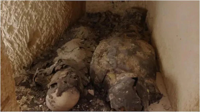
The mystery behind Egyptian queen Cleopatra’s tomb is immense because nobody appears to know where she was buried. However, archaeologists in Egypt are in all probability, close to cracking the code with respect to Cleopatra’s burial after two mummies of high-status individuals, who lived in her era, have been discovered at Taposiris Magna – a temple on the Nile delta.
A discovery that it is being described as “sensational” because it shows the importance of a necropolis that is being linked to her by the latest finds.
Although the burial chamber had been undisturbed for 2,000 years, the mummies are in a poor state of preservation because water had seeped through.
The two mummies found inside a sealed tomb at Taposiris Magna, that would originally have been completely covered with gold leaf.
But crucial evidence reveals they were originally completely covered with gold leaf, a luxury afforded only to those from the top tiers of society. Perhaps these two individuals had interacted with Cleopatra herself, archaeologists suggest.
The opening of the first-ever intact tomb found at Taposiris Magna was witnessed by cameras for a new Channel 5 documentary, The Hunt for Cleopatra’s Tomb, to be screened.
The temple is located near Alexandria, the capital of ancient Egypt and where Cleopatra killed herself in 30 BC
It is presented by Dr Glenn Godenho, a senior lecturer in Egyptology at Liverpool University, who described the discovery as phenomenal.
“Although now covered in dust from 2,000 years underground, at the time these mummies would have been spectacular. To be covered in gold leaf shows they … would have been … important members of society,” he said.
The mummies have been X-rayed, establishing that they are male and female. One suggestion is they were priests who played a key role in maintaining the pharaohs’ power. One bears an image of a scarab, symbolising rebirth, painted in gold leaf.
Cleopatra was the last of a ruthless dynasty that ruled the Ptolemaic kingdom in Egypt for almost three centuries. Yet not a single Ptolemaic pharaoh’s tomb has been found.
Excavations at Taposiris Magna are headed by Dr Kathleen Martínez, who, after working there for over 14 years, is more convinced than ever Cleopatra’s tomb will be found there. Only a tiny percentage of the vast site has been explored.
Dr Glenn Godenho and Dr Kathleen Martinez inside Taposiris Magna temple near Alexandria in Egypt
In the show, cameras film her as the burial chamber with two mummies is opened up for the first time. After an initial limestone slab is removed with a chisel and hammer, she peers through a small hole, exclaiming: “Oh my god, there are two mummies … See this wonder.”
Osteoarchaeologist, Dr Linda Chapon, working to conserve the two mummies found inside a sealed tomb at Taposiris Magna
Her previous discoveries include a headless statue of a pharaoh, believed to be King Ptolemy IV, Cleopatra’s ancestor, and a foundation plate with an inscription showing that the temple was dedicated to the goddess Isis. Cleopatra saw herself as the “human incarnation of Isis”, Martínez said.
At the site of the temple altar, where priests would have made offerings to the gods, 200 coins bearing Cleopatra’s name and her face have been discovered.
This “incredible find” not only links Cleopatra directly to Taposiris Magna but also reveals a striking image of the queen, Godenho says in the documentary.
While its prominent nose and double chin may not suggest the classical beauty immortalised by Hollywood and Elizabeth Taylor, it is how she would have wanted to be seen as the coins would have been pressed using her direct instructions.
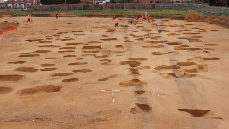
Anglo-Saxon Cemetery Excavated in the East of England
BBC News reports that an Anglo-Saxon cemetery that may date to the sixth century A.D has been found at a site slated for residential development in the East of England, within the border of the Kingdom of the East Angles.
The Anglo-Saxon cemetery is believed to date back to the same period as the famous Sutton Hoo burial site near Woodbridge
Brooches, pottery, small iron knives, wrist clasps, amber and glass beads, and silver pennies were uncovered among the more than 200 burials.
The grave included the bones of men , women and children and objects including brooches, small iron knives and silver pennies. Suffolk’s Archaeological Service said studies would help establish the graveyard’s links to other local sites
A spokesman said the site “lies within the Kingdom of the East Angles, made famous by the royal burial ground at nearby Sutton Hoo”.
Sutton Hoo, discovered in 1939, included two cemeteries from the 6th to 7th centuries and a ship burial full of treasures believed to be the final resting place of King Raedwald.
Artefacts which also include wrist clasps, strings of amber and glass beads, should eventually be available for public display.
Many of the skeletons are only visible as “sand-silhouettes”, a delicate form of preservation.
The site appears to contain several generations of a small farming community and the county council’s archaeological service said the excavation of such cemeteries in their entirety was rare in England, which made it “nationally significant”.
“It is important we oversee and record this work so that we can understand the community buried here and its connections to other finds in Oulton and the nearby settlements and cemeteries at Carlton Colville and Flixton,” said the spokesman.
Artefacts including copper-alloy brooches, wrist clasps, strings of amber and glass beads, small iron knives and silver pennies were discovered
Andrew Peachey, of Archaeological Solutions Ltd, which carried out the excavations, said the remains of 17 cremations and 191 burials were “painstakingly excavated”.
“Due to the highly acidic soil the skeletons had mostly vanished and were luckily preserved as fragile shapes and shadows in the sand,” he said.
Mr Peachey added many of the artefacts were so fragile they had “to be block-lifted for micro-excavation in the labs at Norfolk Museum Service”.
Remains found at the site had to be “painstakingly excavated” and fragments of wooden coffins were found
The remains have now been fully excavated ahead of the Persimmon Homes Anglia housing development.
They will undergo specialist analysis and eventually go on public display.
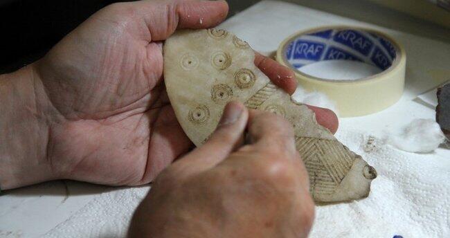
4,300-Year-Old Figurines Unearthed in Central Anatolia
Hurriyet Daily News reports that a team of researchers led by Fikri Kulakoğlu of Ankara University uncovered more than a dozen 4,300-year-old figurines thought to depict gods and goddesses at the Kültepe mound in central Anatolia. Previous excavation at the site uncovered 35 similar figurines in one room of the same building.
Due to its ashy soil that is some 25 kilometres from the city centre of Kayseri and has continued ever since excavations began 72 years ago in the region called “Kültepe.”
This year, statues of God and Goddess from 4,300 years of age, assumed by Anatolians, were found during the excavations. The figurines will be on display in the temporary exhibition at the Kayseri Museum.
Archaeologists work at the Kültepe archaeological site, Kayseri, central Turkey, Sept. 14, 2020.
Some of the statuettes found recently at the Kültepe archaeological site, Kayseri, central Turkey, Sept. 10, 2020.
Ankara University Faculty of Language and History-Geography member and the head of Kültepe excavations, Professor Fikri Kulakoğlu, told the state-run Anadolu Agency that one of the two tablets taken out of Kültepe in the late 1800s and sold to an antique shop in Istanbul had gone to the British Museum and the other to the Louvre Museum.
Stating that scientists, who were curious about the city mentioned in the tablets, came to Turkey but could not find any tablets, Kulakoğlu said: “There was a Czech scientist named Bedrich Hrozny.
This scientist is the first person in the world to solve the Hittite language. This person came to Kültepe in Kayseri to find out where the city of Kaniş mentioned on the tablets is.
He destroyed one-third of the palace that we call ‘Warşama Palace.’ He dug a hole like a crater according to the excavation techniques of that time.”
“He was disappointed that he could not find a tablet. He drew the attention of his coachman, who asked, ‘What happened to my master?’ He answered that he could not find a tablet.
The coachman said, ‘You dug the wrong place, the tablets are not there, but in Mehmet Ağa’s field.’ He went back and started excavations in the place we call Karum, but he could not find many tablets,” he added.
“Meanwhile, there was an epidemic of malaria in the region. Hrozny, who was a former soldier, brought a quinine tablet against malaria with him. People came to him because of the epidemic, they wanted medicine.
He gave them a quinine tablet in return for a cuneiform tablet. Thus, he collected tablets from the villagers. Thanks to the tablets that he collected, which proved that Kültepe was the city of ‘Kaniş’ mentioned in the first tablets.
He took the tablets to his country and returned them to Turkey in 1936. The tablets in the Istanbul Archeology Museum are the ones he studied and returned later,” the professor said.
Kulakoğlu stated that they have been looking for an answer to the question, “What was Anatolia like in the Ancient Bronze Age, the period before the Assyrian merchants came to Anatolia?” since 2009, and said that they have continued excavations in the area of Kaniş, which is called the “upper city.”
Reminding that they found 35 god and goddess figurines collectively in the excavations carried out in the room of a building in 2017, Kulakoğlu said: “We found 15 more idols [statuettes] this year. Excavations continue in this area.
The building we excavated is probably an official, religious, a very large and unique place in Anatolia. The idols extracted from here are the works that depict the beliefs of the Anatolian people and the beings they worshipped 4,500 years ago.”
“Some of them are sitting on the throne and some are made schematically. These are works that are not available anywhere but Kültepe. You find a work worshipped by a person 4,500 years ago and bring it to light; this is exciting.”
He added that they were planning to exhibit them at the Kayseri Museum with a temporary exhibition.
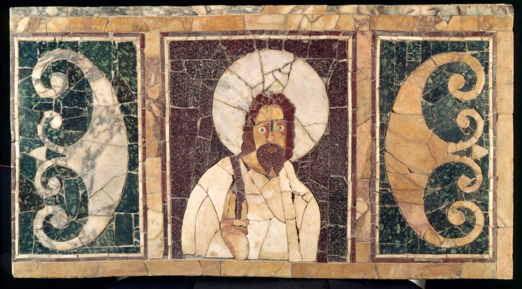
Egypt dig unearths ‘early image of Jesus’ in a mysterious underground tomb
Jesus image has been replicated countless times in churches and artwork, but a team of Spanish archaeologists believe they have found one of the earliest images of Jesus.
A mysterious underground room dating from between the sixth and seventh century AD holds an image of a young man with curly hair, who appears to be giving a blessing among other Coptic images.
The Catalan experts who discovered the site in the ancient Egyptian city of Oxyrhynchus think it was the final resting place for a writer and a number of priests.
A miraculous discovery! An underground room dating from the sixth century holds an image of a young man with curly hair, who appears to be giving a blessing (pictured) and one expert thinks it could be one of the earliest paintings of Jesus Christ. The image, which is seen here, has been protected from the sun with a thin layer of material
A miraculous discovery! An underground room dating from the sixth century holds an image of a young man with curly hair, who appears to be giving a blessing (pictured) and one expert thinks it could be one of the earliest paintings of Jesus Christ. The image, which is seen here, has been protected from the sun with a thin layer of material
THE UNDERGROUND ROOM
The structure dates from between the sixth and seventh century AD in the Coptic period and holds what could be an image of Jesus. It shows a young man with curly hair, dressed in a short tunic and with his hand raised as if giving a blessing
The room is thought to be a tomb for a writer and several priests, based upon artefacts found inside it, including a metallic ink well. It lies in what was the ancient city of Oxyrhynchus on a processional route between the Nile and a temple dedicated to Osiris – the ancient Egyptian god of the underworld
There is another mysterious structure closeby, linked with a flight of well-worn steps, which experts think might be another temple.
The find has been heralded as ‘exceptional’ by Josep Padró who is leading the exhibition and said the figure accompanies symbols and images of plants that are thought to date from the Coptic period of the first Christians.
Dr Padró, Emeritus Professor at the University of Barcelona, told La Vanguardia newspaper that the figure is that of ‘a young man with curly hair, dressed in a short tunic and with his hand raised as if giving a blessing.’
‘We could be dealing with a very early image of Jesus Christ.’
Archaeologists are now working to translate inscriptions surrounding the figure in the painting on the wall of the rectangular crypt in a bid to ascertain the man’s identity. The underground structure measures around eight metres long and four metres deep.
Experts from the University of Barcelona, the Catalan Egyptology Society and the University of Montpellier are also unsure of what the function of structure originally was, but said that the underground stone structure is ‘excellent’ quality.
Ancient centre: The Catalan experts who discovered the site in the ancient Egyptian city of Oxyrhynchus (marked on the map) think it was the final resting place for a writer and a number of priests
Tools of the trade: The team of archaeologists also found working tools of a scribe that were buried in the tomb. They include a metallic inkpot which is still full of ink and two new pens for the pens (pictured) for the deceased to write during the eternal life
They also found working tools of a scribe that was buried in the tomb. They include a metallic inkpot which is still full of ink and two new pens for the deceased to write during the eternal life.
Dr Padró said: ‘The archaeological site of Oxyrhynchus is known for the thousands of papyri found there, but any scribe was found to date.’
While there were no inscriptions hinting at the identity of the deceased, the remains show that the scribe was probably around 17 year’s old and lived during the Coptic Roman period.
Archaeologists and engineers had to move around 45tonnes of rock to get to the hidden artwork and another unidentified structure close by, which is connected to the tombs by a set of very worn steps is currently being investigated.
Gateway to the afterlife? The underground structure is situated in the middle of what was a processional route joining the Nile with the Osireion – the temple dedicated to Osiris – which is one of the greatest findings of Oxyrhynchus. The god is pictured in this painting in the tomb of Pashedu in Luxor, Egypt alongside – Orus, the hawk god protector of Osiris
No-one is sure of what lies inside it, but experts from the University of Barcelona think it might be a temple, perhaps dedicated to god Serapis – the Hellenistic form of Osiris who is the ancient Egyptian god of the afterlife.
The structures are situated in the middle of what was a processional route joining the Nile with the Osireion, the temple dedicated to Osiris, which is one of the greatest findings of Oxyrhynchus.
Egypt’s Minister of Antiquities, Mohamed Ibrahim, has become personally involved with the excavation, The Local reported. The Egyptian ministry will develop the archaeological site to preserve early Christian artwork.