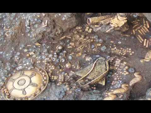
Spectacular Ancient tomb treasures from the Republic of Georgia kingdom of Colchis
This exhibition is the first showing in Britain of spectacular tomb treasures from the Republic of Georgia, known in ancient classical times as Colchis and familiar to every schoolchild as the land to which the Greek hero Jason led the Argonauts in search of the Golden Fleece.
Recent archaeological excavations have thrown much new light on the rich culture of this region, including their lavish gold-adorned burials and ritual practices in which the local wine played a central role. These finds offer a unique insight into a fascinating and little-known ancient culture on the periphery of the classical world.
The magnificent gold and silver jewellery, sculpture and funerary items displayed here derive from tombs and sanctuaries of the 5th to the 1st centuries BC at the site of Vani.
Most of the more than 140 treasures have never been seen outside Georgia before this exhibition tour. They offer both a spectacular array of exquisite works of art and a valuable window onto the interaction of indigenous Georgian and classical Greek culture in antiquity.
Land of the Golden Fleece
The region known to the ancient Greeks as Colchis now lies within modern Georgia. This placed it to the east of the ancient Greek world, north of the Assyrian and Persian empires and south of the nomadic Scythians.
This region is protected on the north by the Caucasus Mountains and formed a natural trade route, which ran from the eastern edge of the Black Sea to Central Asia, as far as India.
It was rich in natural resources, especially metals, and was known to the Greek world as an area ‘rich in gold’. According to legend, this was the place to which Jason set out with his Argonauts on their quest for the Golden Fleece.
Archaeological evidence shows that as early as the 8th century BC the Greeks had begun establishing colonies along the shores of the Black Sea, and several trading posts (known as emporia) thrived on Colchian shores.
While the Achaemenid Persians do not appear to have been actively present in Colchis, the Greek historian Herodotos (Histories III, §97, 3-4) records that the Colchians paid a tribute of one hundred men and one hundred women to the Persian empire every four years, presumably as slaves.
By the 6th century BC, the various regions of Colchis united formally into one kingdom made up of a network of culturally and politically connected cities.
Vani
Vani is one of the best-known sites in Colchis. It is located on a hilltop in the fertile region between the Sulori and Rioni Rivers.
The Vani archaeological site is a multi-layer archaeological site in western Georgia, located on a hill at the town of Vani in the Imereti region. It is the best-studied site in the hinterland of an ancient region, known to the Classical world as Colchis, and has been inscribed on the list of the Immovable Cultural Monuments of National Significance.
The ancient name of the city is still unknown, but archaeological evidence shows that there was already a small settlement here by the 8th century BC. From the 6th to the end of the 4th century BC, Vani’s size and wealth increased dramatically.
During this period, the city became the political and administrative center of the area, managing the cultivation of grapevines and the harvesting of wheat in the surrounding hills and plains. By about 250 BC, it appears that Vani had been transformed into a sanctuary city with its inhabitants moving outside the city walls.
The unstable political environment of the Hellenistic period (3rd-1st centuries BC) affected Colchis a great deal. Fortifications at Vani, including defensive walls and towers, indicate an increased threat of attack.
The city came to a violent end around 50 BC when it was destroyed by two successive invasions within a few years, the first probably by the Bosporans from the northwest under their leader Pharnaces, and the second by Mithridates VII from Pontus (southwest of Colchis).
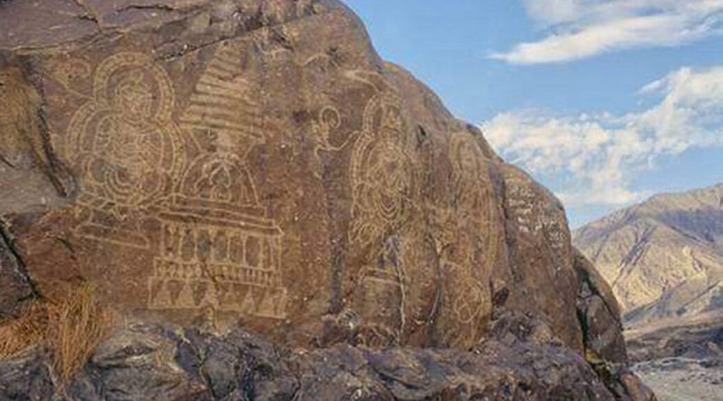
A resident of the area, Araib Ali Baig, wrote, “The art of rock carving is present in all regions of Gilgit Baltistan, mainly in the districts of Diamir, Hunza and Nagar and Baltistan”. “Speaking specifically of Baltistan, these engravings can be seen on former settlements and popular old routes along the Indus and Shyok”.
This is how China is ruining Buddhist treasure in Pakistan Occupied Ladakh
Since the Chinese company develops Diamer-Bhasha, a dam in Pakistan’s Gilgit – Baltistan region occupied Ladakh, most of the Buddhist relics in an around some of the ancient villages would be submerged.
The dam has come as an end to the rich Buddhist culture and treasure that was dominant before the 14th and 15th centuries when forced conversion by Muslim invaders from Central Asia started in the region.
However it is interesting to know that even the local Muslim population is criticizing the construction of the dam and destruction of Buddhist heritage.
Ancient Buddhist rock inscriptions in Gilgit Baltistan
The local population says that the Buddhist relics found in most of the villages in a form on engraved symbols on rocks, Gautam Buddha’s statues made of rocks among many other artifacts. These could help in making the region of the occupied areas as self-dependent by promoting tourism.
The controversy erupted in Gilgit Baltistan soon after the Pakistan government on 13 May signed Rs 442 billion contract with a Chinese company for the construction of the dam that would submerge about 50 villages uprooting a large chunk of the population.
The Diamer-Bhasha Dam is located on the Indus River in northern Pakistan between Kohistan district in Khyber Pakhtunkhwa and Diamer district in Gilgit Baltistan.
Many Muslim residents of the area have on the social media joined the debate against the destruction of the rich heritage that the dam would cause in the area.
One of them remarked that “the wealth of Indic history spanning over millennia will soon be submerged under waters of the dam in Gilgit Baltistan”.
A resident of the area, Araib Ali Baig, wrote, “The art of rock carving is present in all regions of Gilgit Baltistan, mainly in the districts of Diamir, Hunza and Nagar and Baltistan”. “Speaking specifically of Baltistan, these engravings can be seen on former settlements and popular old routes along the Indus and Shyok”.
The project will destroy a number of petroglyphs that are the talking rocks of the region. Unplanned development activities, commercial painting practices, chalk on the walls, hatred of local people for these pre-Islamic sculptures, and apathy from government departments have also led to the rapid disappearance of these historic rock art, said a comment.
Baig commented, “Inscriptions which were destroyed during the conversion of the local population to Islam in the 14th and 15th centuries AD. Even today, these inscriptions are easy to find in the villages located mainly on the east bank of the Indus, but they are in a state of disrepair”.
“Yes these sculptures belong to Buddhism. They can attract millions of tourists across the globe. Irrespective of religion we should preserve this ancient heritage”, commented another resident of POJK.
An archaeologist of the area, Dr. Ahmad Hasan Dani has classified these rock engravings into four categories. The oldest category includes rock carvings dating from at least two millennia BC and even dating back to the fifth or sixth millennium BC.
Such engraved rocks are of great heritage importance and the Buddhist spiritual and temporal leader Dalai Lama during a recent visit to Leh had called for preserving these ancient rocks scattered along the Indus River and other places in the Ladakh union territory (UT).
Dalai Lama made the appeal when he came to know that the ancient rocks with inscriptions of the Kushan period and the Bronze Age were decaying due to negligence.
Such rocks are scattered throughout Ladakh but the largest cluster of rocks carrying inscriptions and images of animals, hunting scenes, human giants, masks, and various other themes is in the Murgi-Tokpo Village that was properly preserving these.
What Ear Infections Going Back 15,000 Years Tell Us About Human Health
Tel Aviv University researchers have found evidence of ear infections of the remains of people living in the Levant around 15,000 years ago in the skull.
The lead author Dr. Hila May of the Anatomy and Anthropology Department, TAU Sackler Faculty of Medicine, and Dan David Center for Human Evolution and Biohistory Studies at the Medicine Faculty, Steinhardt Museum of Natural History, says: “We seek to determine the impact of our environment on illness throughout different periods.”
“We were able to detect signs of prolonged inflammation in our middle ear using advanced technologies and special methods developed in our laboratory.”
The researchers found a decline in morbidity as a result of ear infections following the transition from hunting and gathering to farming on account of changes in living conditions. A peak in morbidity, however, was observed in a sedentary population living about 6,000 years ago (Chalcolithic period).
Dr. May says the reason for this is twofold: social and environmental: “We know from archaeological excavations of this period, similar to preceding periods, people lived in a communal area where all activities, from cooking to raising livestock, took place.
As a result, the population density in the ‘home’ was high, hygiene was poor and they suffered from indoor air pollution. Two other factors are known about this period – dietary change, the advent of dairy consumption, and climate change, a dip in temperature and a rise in rainfall, also contributed to the prevalence of ear infections.”
A story in the skulls
Until the advent of antibiotics in the 20th century, ear infections developed into chronic conditions, or, due to complications, caused permanent loss of hearing or even death.
“Ear infections are still a very common childhood ailment, with over 50 percent of young children today still suffering from an ear infection at one point or another,” explains Dr. May.
“The reason for this is that the tubes that channel fluid from the middle ear to the mouth are underdeveloped in young children, so fluids that accumulate in the ear ultimately cause inflammation.”
“A prolonged ear infection would cause permanent damage to the bony wall of the middle ear, which is remarkably preserved into adulthood, so when we sought to investigate changes in communal health over time in our region, we chose to focus on ear infections, developing a special method for doing so,” she adds.
The scientists used a video scope, a tiny camera mounted at the end of a flexible tube, which they inserted through the ear canal to the middle ear to observe its bony walls.
In addition, they scanned skull remains with a high-resolution micro-CT, and also examined the middle ear’s bony wall using a light microscope.
More room, fewer infections
As living conditions improved, morbidity as a result of ear infections dropped, according to the study.
“Houses were larger and featured several rooms, including separate areas for specific activities, i.e. the kitchen was set up in a separate room or outside, and livestock were kept in a separate area,” she says. “The change in lifestyle and climate is reflected in a decline in morbidity.”
“Our study deals with the impact of the environment and social behavior on morbidity rates, and to do so, we examined a common disease that has accompanied humanity since inception – the ear infection,” concludes Dr. May.
“Understanding how diseases appear, spread, and disappear throughout human history can help prevent and find solutions to contemporary illnesses.
The study clearly points out risk factors and shows how lifestyle changes can affect the incidence of the disease. In both ear infections and COVID-19, social distancing and adherence to hygiene reduced the spread of infection, while close quarters and unhygienic living conditions saw infections spike.”
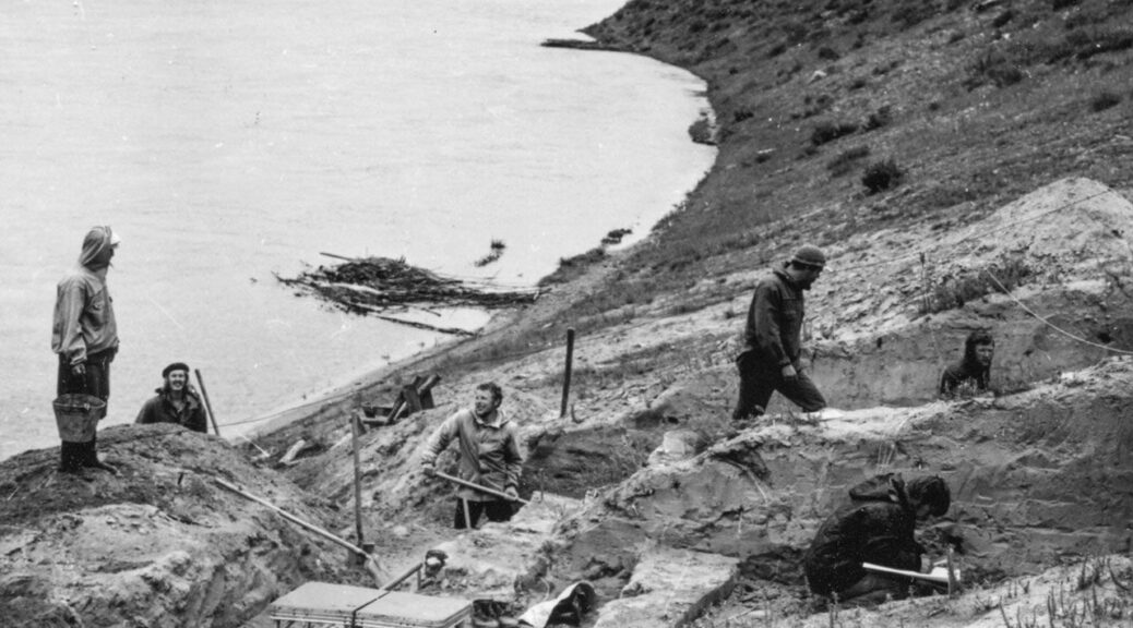
14,000-Year-Old Ancestor of Native Americans Identified in Russia
Since the Upper Paleolithic, modern humans have lived near Baikal Lake, and left a rich archeological record behind.
Russian archaeologists in 1976 excavating the Ust’-Kyakhta-3 site on the banks of the Selenga River
The region’s ancient genomes also uncovered multiple genetic turnovers and admixture events, indicating that the transition from the Neolithic to the Bronze Age was facilitated by human mobility and complex cultural interactions. The nature and timing of these interactions, however, remains largely unknown.
The reports of 19 newly sequenced human genomes, including one of the oldest ones recorded by the area of Lake Baikal, are presently in a new study published in the journal Cell.
Led by the Department of Archaeogenetics at the Max Planck Institute for the Science of Human History, the study illuminates the population history of the region, revealing deep connections with the First Peoples of the Americas, dating as far back as the Upper Paleolithic period, as well as connectivity across Eurasia during the Early Bronze Age.
The deepest link between peoples
“This study reveals the deepest link between Upper Paleolithic Siberians and First Americans,” says He Yu, the first author of the study. “We believe this could shed light on future studies about Native American population history.”
Past studies have indicated a connection between Siberian and American populations, but a 14,000-year-old individual analyzed in this study is the oldest to carry the mixed ancestry present in Native Americans.
Using an extremely fragmented tooth excavated in 1976 at the Ust-Kyahta-3 site, researchers generated a shotgun-sequenced genome enabled by cutting edge techniques in molecular biology.
A fragmented tooth belonging to a close cousin of today’s Native Americans
This individual from southern Siberia, along with a younger Mesolithic one from northeastern Siberia, shares the same genetic mixture of Ancient North Eurasian (ANE) and Northeast Asian (NEA) ancestry found in Native Americans and suggests that the ancestry which later gave rise to Native Americans in North- and South America was much more widely distributed than previously assumed.
Evidence suggests that this population experienced frequent genetic contacts with NEA populations, resulting in varying admixture proportions across time and space.
“The Upper Paleolithic genome will provide a legacy to study human genetic history in the future,” says Cosimo Posth, a senior author of the paper. Further genetic evidence from Upper Paleolithic Siberian groups is necessary to determine when and where the ancestral gene pool of Native Americans came together.
A web of prehistoric connections
In addition to this transcontinental connection, the study presents connectivity within Eurasia as evidenced in both human and pathogen genomes as well as stable isotope analysis.
Combining these lines of evidence, the researchers were able to produce a detailed description of the population history in the Lake Baikal region.
The presence of Eastern European steppe-related ancestry is evidence of contact between southern Siberian and western Eurasian steppe populations in the preamble to the Early Bronze Age, an era characterized by increasing social and technological complexity. The surprising presence of Yersinia pestis, the plague-causing pathogen, points to further wide-ranging contacts.
Recent view on the Selenga River close to the archeological site Ust-Kyakhta-3
Although spreading of Y. pestis was postulated to be facilitated by migrations from the steppe, the two individuals here identified with the pathogen were genetically northeastern Asian-like. Isotope analysis of one of the infected individuals revealed a non-local signal, suggesting origins outside the region of discovery.
In addition, the strains of Y. pestis the pair carried is most closely related to a contemporaneous strain identified in an individual from the Baltic region of northeastern Europe, further supporting the high mobility of those Bronze age pathogens and likely also people.
“This easternmost appearance of ancient Y. pestis strains is likely suggestive of long-range mobility during the Bronze Age,” says Maria Spyrou, one of the study’s co-authors.
“In the future, with the generation of additional data we hope to delineate the spreading patterns of plague in more detail,” concludes Johannes Krause, senior author of the study.
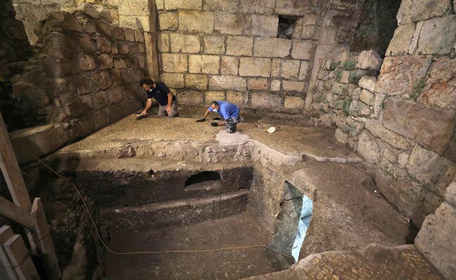
Researchers Find 1,400-Year-Old Rooms Under Jerusalem’s Western Wall
Previously, archeologists discovered three ancient subterranean chambers located in the bedrock under the Western Wall plaza in Jerusalem.
The excavation was part of a larger project to create an underground expanse showcasing various eras.
Two thousand years ago, the chambers were consisting of an open courtyard and two rooms, were carved on top of one another and connected by hewn staircases.
According to a statement from the Israel Ancientities Authority, inside the chambers, archaeologists discovered clay-cooking pots, cores of oil lamps, a stone mug, and a qalal or a large stone basin that was used to hold water for rituals.
The archeologists also found a long carving at the entrance to the chambers for shelves and depressions for door hinges and bolts, as well as round, square and triangular niches carved into the walls, some of which could have been used to place oil-lamps in.
These findings likely mean that these chambers were used daily, according to the statement. But it’s not clear what they were actually used for.
“Perhaps, it served as a pantry for an overhead structure that didn’t survive, or as a hewn space” for living underground, Mordechai Eliav, the director of the Western Wall Heritage Foundation, said in the statement.
Oil candles were among the items discovered in the underground chambers.
“We’re asking ourselves what was the function of this very complex rock-cut system?” co-director of the excavation Barak Monnickendam-Givon said in an accompanying video.
People could have lived in these underground chambers or stored food or groceries there for possibly another long-gone building above it.
“Another possibility is that this system was used for hiding during the siege on Jerusalem 2000 years ago when the Roman legions conquered the city,” he said.
The subterranean chambers were hidden beneath the white mosaic floor of a public building that was created around 1,400 years ago during the Byzantine period.
The building was renovated about 1,250 years ago, during the Abbasid period, according to the statement. In the 11th century, the building was destroyed and the subterranean chambers, along with other finds, were buried and stayed hidden for centuries.
These chambers were found in the “Beit Strauss” complex, beneath the entrance lobby to the Western Wall Tunnels, which helped the builders of the wall support its massive weight. (The tunnels also contained channels that supplied water to the Second Temple, according to Atlas Obscura).
Archeologists discovered this measuring cup in the chambers.
The complex was likely used by residents of the city during the early Roman period, before Jerusalem was destroyed in A.D. 70, according to a statement from the Israel Antiquities Authority.
The Western Wall is the only remaining part of the Second Temple of Jerusalem, which the Romans destroyed along with the rest of the city, according to the Encyclopedia Britannica.
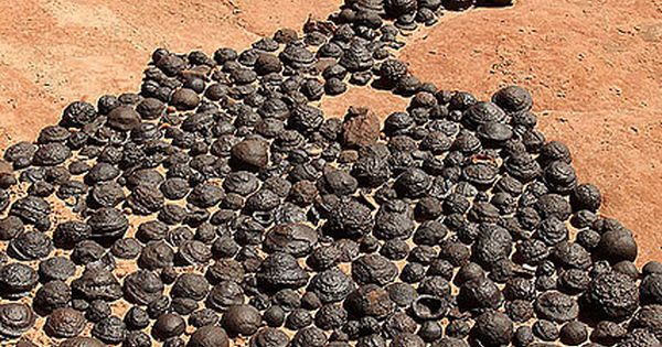
25 Million Old Moqui marbles naturally occurring iron oxide concretions that arise from Navajo sandstone
Walkers wandering through the sandy canyons of Utah sometimes come across a strange sight. Where the Navajo Sandstone loses its iconic peach, orange, and red stripes, hundreds of round, iron-coated stones often litter the ground.
Sandstone balls are cemented with a strong layer of iron oxide minerals. Moqui marbles, the colored stones spread over the Utah and Arizona, are often called as a stone, and they fall off pale, cream-colored Navajo Sandstone beds when wind and water wash away the softer rock are often known by the name Moqui.
For decades, the rocks were simply a geological oddity. Then, look-alikes were discovered on Mars (the so-called Martian blueberries). The milestone — among the early evidence for water on Mars — boosted interest in Earth’s iron baubles.
Now, a new study reveals that the Moqui marbles are no more than 25 million years old — a sharp contrast to the 190-million-year-old Navajo Sandstone. Marbles scattered on sandstone slopes in Grand Staircase-Escalante National Monument are only 2 million to 5 million years old. And on Arizona’s Paria Plateau, the marbles’ iron oxide rind is as young as 300,000 years old, researchers report in the September 2014 issue of the Geological Society of America Bulletin.
“They really represent a record of how water moved the rock millions of years ago, and the next generation can use them to understand water and life on other planets,” said Marjorie Chan, co-author of the new study and a geologist at the University of Utah in Salt Lake City.
Odd balls
The moqui marbles’ precise ages come from a radioactive clock. The iron oxide minerals contain traces of radioactive uranium and thorium, and these decay by expelling helium. Tallying the elements reveals the time since the minerals formed. The innovative technique may help resolve different models of how the stone spheres formed. Scientists agree that the iron comes from the bone-white Navajo Sandstone layers, stripped bare of their mineral paint by percolating groundwater. A subtle film of hematite, or iron oxide, colors the iconic red cliffs and canyons.
Chemical reactions fused the moqui marbles with iron, but the details haven’t been settled. Some researchers now think tiny microbes spurred the chemical process, and that similar concretions on Mars may one day reveal signs of ancient life.
“The discoveries on Mars helped push us to better understand the setting here on Earth, and what we do on Earth feeds back into helping interpret Mars,” Chan told fox news.
Concretions of all shapes and sizes are found all over the world. The curious rocks have inspired fantastical tales of fairies, meteorites and dinosaur eggs, but their origin is fairly mundane. Water flowing through sedimentary rock leaves behind minerals that glue together masses of sand, mud, or other particles. Sometimes, a treasure — like a bone or a shell — hides inside.
The Moqui marbles crop up in the Navajo Sandstone in Arizona and in Utah’s public lands, eroding from the spectacular white cliffs in Zion National Park and the Grand Staircase-Escalante National Monument. Collecting concretions in the parks is prohibited.
Red and white Navajo sandstone in Zion National Park
The iron stones appear almost black, with a pitted surface polished by blowing sand. Other rusty structures formed too, including discs, “flying saucers,” pipes and flat plates. Spiritualists have endowed the marbles with “energy” and dubbed the distinctive shapes as male and female, making them among the only rocks with a gender. Quietly sitting and holding one in each hand is said to calm the spirit, just like meditation.
“I don’t believe that,” Chan said. “I do believe these are important resources, and the geologic landscape is our heritage.”
Cloaked in iron
The Navajo Sandstone was once the biggest expanse of dunes on Earth. Its color comes from flakes of iron-rich minerals blown in and buried with the quartz sand. After the dunes were blanketed and buried by younger geologic layers, the iron enrobed the sand grains, giving the Navajo Sandstone its amazing colors and patterns.
Eons later, the moqui marbles were born. The concretions owe their existence to massive tectonic shifts in the Southwest, researchers think. Some 20 million years ago, the Colorado Plateau started to bob up like a cork. The entire plateau has lifted about 1.2 miles (2 kilometers).
The tectonic uplift warped its rock layers, trapping oil and gas. When a mixture of water and natural gas flowed through the Navajo Sandstone, it stripped away the rusty coating, bleaching the rocks from red to creamy white. Chan thinks this iron-rich water crept through the sandstone until it reached a crack, hole, or layer where the water chemistry was different and iron settled out of the water.
The chemical reactions first covered each sand grain with iron, creating tiny spheres. The spheres grew, layer by layer, making contact with others nearby until some spheres connect into one large mass. Collectors on private property sometimes find odd, knobby clumps that appear to be partially formed spheres, where the process may have halted halfway through.
The spheres grew layer by layer, making contact with others nearby until many spheres became one large ball.
“These round concretions have a self-organizing pattern, like people at a party,” Chan said. “The natural pattern is for people to gather together in conversation groups, and the groups are going to be round.”
The results of the new study suggest that the first iron-oxide batch formed 20 million to 25 million years ago, and the next set was added 2 million to 3 million years ago. This younger group matches up with another major event: It’s when the Colorado River started cutting through the Navajo Sandstone near the mouth of the Escalante River, which likely changed groundwater flow through the region. These younger marbles are mostly goethite instead of hematite, which may reflect the changing chemistry of the groundwater.
Iron eaters
The younger ages also support a different model for how the concretions formed, according to David Loope, a geologist at the University of Nebraska-Lincoln, who was not involved in the study. Loope thinks the Moqui marbles were transformed by microbes, morphing from one kind of mineral to another as the region’s groundwater chemistry changed.
According to Loope’s model, the marbles were originally siderite, an iron carbonate mineral. The same fluids Chan said had bleached the sandstone deposited the carbonate spheres, only with an added boost of carbon dioxide gas dissolved in the water. When the Colorado River sliced into the Navajo Sandstone 2 million years ago, the groundwater flow and the mineral levels shifted.
The researchers think bacteria helped convert the siderite into hematite. With a powerful microscope, the researchers also discovered tiny structures suggestive of microbial life inside the concretions, similar to tubes seen in Martian meteorites. Some of the hematite rinds resemble siderite crystals — a clue that one mineral ousted the other, Loope, and his colleagues reported in August 2012 in the journal Geology. “We are completely convinced the concretions had siderite precursors,” Loope said.
Link to the past
“Moqui” is a Hopi word that means “dear departed ones.” According to Hopi tradition, spirits of the dead would play with the marbles at night, leaving them behind in the morning to reassure the living that they were happy in the afterlife.
Just as the Moqui marbles embody the Hopi idea of life after death, the iron stones are links to ancient environments on the Colorado Plateau. With the new dating technique, Chan has shown that scientists can start to pinpoint where and when water flowed through rock. The search for historic water routes in the Southwest has engaged researchers for more than century, since the first geologists tried to puzzle out how the Colorado River carved the Grand Canyon.
“A lot of people are just fascinated by these concretions, and maybe geologists haven’t been able to take them seriously in the past,” Loope told Fox News. “I think they pretty clearly hold a lot of information.”
A New Unified Model For Cave Pearls: Insights from Cave Pearls in Carlsbad Cavern, New Mexico, U.S.A.
The Cave of Lechuguilla is the deepest of the Americas, but it is most notable because of its unique shapes, its peculiar geology, and its impermanence.
Nigel Ball in the Chandelier Ballroom in Lechuguilla Cave Carlsbad Boneyard
Agave lechuguilla, a plant species found near his entrance, is called the cavern. Lechuguilla is located in the National Park of Carlsbad Caverns, New Mexico.
Entry to the cave is limited to licensed scientists, survey and excavation teams, and management trips for the national park service.
Lechuguilla Cave offers more than extreme size. It holds a variety of rare speleothems, including lemon-yellow sulfur deposits, 20 feet (6.1 m) gypsum chandeliers, 20 feet (6.1 m) gypsum hairs and beards, 15 feet (4.6 m) soda straws, hydromagnesite balloons, cave pearls, subaqueous helictites, rusticles, U-loops and J-loops.
Lechuguilla Cave surpasses its nearby sister, Carlsbad Caverns, in size, depth, and variety of speleothems, though no room has been discovered yet in Lechuguilla Cave that is larger than Carlsbad’s Big Room.
Scientific exploration has been conducted. For the first time, a Guadalupe Mountains cave extends deep enough that scientists may study five separate geologic formations from the inside.
The profusion of gypsum and sulfur lends support to speleogenesis by sulfuric acid dissolution.
The sulfuric acid is believed to be derived from hydrogen sulfide that migrated from nearby oil deposits.
Therefore this cavern formed from the bottom up, in contrast to the normal top-down carbonic acid dissolution mechanism of cave formation.
Rare, chemolithoautotrophic bacteria are believed to occur in the cave. These bacteria feed on the sulfur, iron, and manganese minerals and may assist in enlarging the cave and determining the shapes of unusual speleothems.
The claim in the BBC documentary series Planet Earth that these bacteria do not derive any energy from the sun is incorrect, as the majority are sulfur-oxidizing bacteria that utilize primarily atmospheric oxygen (derived from sunlight-driven photosynthesis) as an electron acceptor.
Other studies indicate that some microbes may have medicinal qualities that are beneficial to humans.
Lechuguilla Cave lies beneath a park wilderness area. The cave’s passages may extend out of the park into adjacent Bureau of Land Management (BLM) land.
A major threat to the cave is proposed gas and oil drilling on BLM land. Any leakage of gas or fluids into the cave’s passages could kill cave life or cause explosions.
Cave pearl
Small, almost spherical concretion of calcite that is formed in a pool of water in a cave and is not attached to the surface on which it forms. Occasionally saturated water drips into small pools with such vigour that a stalagmite cannot form.
A bit of foreign matter may become coated with calcite, and slight movements of the water may keep the bit in motion while new layers of calcite are added. Concentric layers are added and polished in this way until the cave pearl becomes too large to remain in motion and becomes attached.
Cave pearls in the Pearlsian Gulf, Lechguilla Cave.
Lechuguilla cave
Cave pearls in the Pearlsian Gulf, Lechguilla Cave.
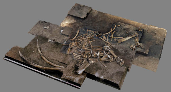
Archaeologists discover almost complete 300,000-year-old elephant skeleton
300,000 years ago in Lower Saxony elephants spread around Schoningen. In recent years there were the remains of at least ten elephants at Palaeolithic sites situated on the edges of the former opencast lignite mine.
Eurasian straight-tusked elephant died by the shores of a lake in Schoningen, Lower Saxony
In cooperation with the National Saxony State Office for Heritage, archeologists at the Senckenberg Center for Human Evolution and Palaeoenvironment at the University of Tubingen have collected for the first time in Schoningen an almost complete skeleton of the Eurasian straight-tusked elephant (Palaeoloxodon Antiquus).
The species has died in what had been the western shore of the lake — what exactly happened and what the biotope surrounding the area was like 300,000 years ago is now being carefully reconstructed by the team. The preliminary study will be published in Archaologie in Deutschland and will be first presented at a press conference in Schoningen on Tuesday the 19th of May.
“The former open-cast mine in Schoningen is the first-rate archive of climate change, as stated by Bjorn Thumler, Lower Saxony’s Science Minister: This must be made even clearer in the future. This is a place where we can trace how humankind went from being a companion of nature to a designer of culture.”
Head of the excavation, Jordi Serangeli, wipes sediment away from the elephant’s foot
The elephant skeleton lies on the 300,000 years old lakeshore in water-saturated sediments. Like most of the finds at Schoningen, it is extraordinarily well preserved as Jordi Serangeli, head of the excavation in Schoningen explains. “We found both 2.3-meter-long tusks, the complete lower jaw, numerous vertebrae and ribs as well as large bones belonging to three of the legs and even all five delicate hyoid bones.”
The elephant is an older female with worn teeth, as archaeozoologist, Ivo Verheijen explains. “The animal had a shoulder height of about 3.2 meters and weighed about 6.8 tonnes—it was, therefore, larger than today’s African elephant cows.”
Pictured above is a composite photograph of the find. Archaeologists suggested the elephant had died due to old age, although they didn’t rule out human hunting
It most probably died of old age and not as a result of human hunting. “Elephants often remain near and in the water when they are sick or old,” says Verheijen. “Numerous bite marks on the recovered bones show that carnivores visited the carcass.”
However, the hominins of that time would have profited from the elephant too; the team found 30 small flint flakes and two long bones which were used as tools for knapping among the elephant bones. Barbara Rodriguez Alvarez was able to find micro flakes embedded in these two bones, which proves that the resharpening of stone artifacts took place near to the elephant remains. She also refits two small flakes, this confirms that flint knapping took place at the spot where the elephant skeleton was found.
“The Stone Age hunters probably cut meat, tendons and fat from the carcass,” says Serangeli. Elephants that die may have been a diverse and relatively common source of food and resources for Homo heidelbergensis. Serangeli says that according to current data, although the Palaeolithic hominins were accomplished hunters, there was no compelling reason for them to put themselves in danger by hunting adult elephants. Straight-tusked elephants were a part of their environment, and the hominins knew that they frequently died on the lakeshore.
Several archaeological sites in the world have yielded bones of elephants and stone artifacts, e.g. Lehringen in Lower Saxony, Bilzingsleben in Thuringia, Grobern in Saxony-Anhalt, Benot Ya’aqov in Israel, Aridos 1 and 2 as well as Torralba and Ambrona in Spain, Casal dei Pazzi in Rome, Cimitero di Atella, Poggetti Vecchi in Italy and Ebbsfleet in England. Some of these sites have been interpreted as examples of elephant hunts in the Lower or Middle Palaeolithic.
Reconstruction of the Schöningen lakeshore as the humans discovered the carcass of the straight-tusked elephant.
“With the new find from Schoningen we do not seek to rule out that extremely dangerous elephant hunts may have taken place, but the evidence often leaves us in some doubt. To quote Charles Darwin: ‘It is not the strongest that survives, but the one who can adapt best’. According to this, the adaptability of humans was the decisive factor for their evolutionary success and not the size of their prey.”
The fact that there were numerous elephants around the Schoningen lake is proven by footprints left behind and documented approximately 100 meters from the elephant excavation site. Flavio Altamura from Sapienza University of Rome who analysed the tracks, tells us that this is the first find of its kind in Germany.
“A small herd of adults and younger animals must have passed through. The heavy animals were walking parallel to the lakeshore. Their feet sank into the mud, leaving behind circular tracks with a maximum diameter of about 60 centimeters.”
The Schoningen sites have already provided a great deal of information about plants, animals and human existence 300,000 years ago during the Reinsdorf interglacial. The climate at that time was comparable to that of today, but the landscape was much richer in wildlife.
About 20 large mammal species lived around the lake in Schoningen at that time, including not only elephants but also lions, bears, sabre-toothed cats, rhinoceroses, wild horses, deer and large bovids. “The wealth of wildlife was similar to that of modern Africa,” says Serangeli.
The discoveries in Schoningen include some of the oldest fossil finds of an auroch in Europe, of a water buffalo, and three saber-toothed cats. In Schoningen archaeologists also recovered some of the world’s oldest and best-preserved hunting weapons: ten wooden spears and at least one throwing stick.
Stone artifacts and bone tools complete the overall picture of the technology of the time. “The lakeshore sediments of Schoningen offer unique preservation and frequently provide us with detailed and important insights into the culture of Homo heidelbergensis,” says Nicholas Conard, head of the Schoningen research project.
Further detailed analyses of the environmental and climatic conditions at the time of the elephant’s death are taking place at the Technische Universitat Braunschweig, the University of Luneburg, and the University of Leiden (The Netherlands). The excavations in Schoningen are financed by the Ministry of Science and Culture of Lower Saxony.