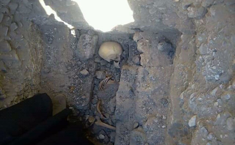
Teenage girl’s skeleton discovered in a mysterious grave near Egyptian pyramid
The skeletal remains, hugging in the crypt, of a 13-year-old girl, have been discovered by Egyptian archeologists excavating the pyramid ruins 60 miles out of Cairo.
It is a mystery how or when she died, though the experts say the site itself dates back to the end of the Third Dynasty roughly 4,600 years ago.
The cemetery was empty apart from the skeleton, which was buried in the squatting position, but the team also found two animal skulls and three ceramic vessels nearby that were likely placed as funerary offerings. The skull offerings appear to have come from bulls, according to Egypt’s Ministry of Antiquities.
While the newly-discovered bones (left) indicate the remains belong to a girl who was around 13 years old when she died, much about the burial and the skull offerings (right) are still unclear, the researchers say
Researchers came across the burial during work on the partially-collapsed Meidum pyramid, where the team is excavating a cemetery built near the end of the Third Dynasty.
It’s thought that construction on the Meidum period began at the command of the Third Dynasty’s last pharaoh, Huni, and was continued by Sneferu, the first pharaoh of the Fourth Dynasty. Previous efforts at the site uncovered the tomb of Prince Nefar-Maat, Sneferu’s oldest son.
The latest burial was found surrounded by a partially intact brick wall, and the team is now working to restore and reinforce the structures
While the newly-discovered bones indicate the remains belong to a girl who was around 13 years old when she died, much about the burial and the offerings are still unclear.
Researchers do not know the identity of the buried teenager.
The latest burial was found surrounded by a partially intact brick wall, and the team is now working to restore and reinforce the structures.
Elsewhere, in the Sinai Peninsula, the Antiquities Ministry says it discovered an ancient workshop that was used to build and repair ships thousands of years ago.
The site dates back to the Ptolemaic era (332 B.C.-30 B.C) and was found during excavations in the Tel Abu Saifi archaeological site, which is said to have once been the location of the Roman fortress Silla.
The find includes two dry dockyards where the ancient ships were worked on.
Researchers say it dates to the Greco-Roman period in Egypt, which lasted from the arrival of Alexander the Great in the 4th century until the 7th century when the Islamic conquest swept the region.
90,000-year-old human hybrid found in ancient cave
The idea of free love seems to have started even earlier than in the 1960s. A small bone fragment belonging to an ancient hominin called “Denny” by the team, who had a mother Neanderthal and a dad Denisovan-the two nearest extinct relatives of the living humans today, was discovered in an international team of researchers.
90,000-year-old bones provide the first direct evidence of interbreeding between Neanderthals and their close relatives the Denisovans.
The two races have been known to live on the Eurasian Mixed Continent, Neanderthals in the west of the continent until some 40,000 years ago and Denisovans in the east.
Previous genetic studies of ancient hominin remains have shown that they sometimes interbred, but Denny is the only known example of a first-generation child with equal parts Neanderthal and Denisovan DNA.
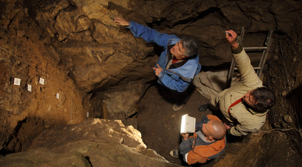
The bone fragment was found in 2012 at Denisova Cave in Russia and taken to the Max Planck Institute in Leipzig for genetic analysis, after being identified as a hominin bone due to its protein composition. It is thought that the bone is a fragment of the arm or leg of a young female, who would have been aged around 13 when she died some 90,000 years ago.
“It is striking that we find this Neanderthal/Denisovan child among the handful of ancient individuals whose genomes have been sequenced,” said Prof Svante Pääbo at the Max Planck Institute. “Neanderthals and Denisovans may not have had many opportunities to meet. But when they did, they must have mated frequently – much more so than we previously thought.”
Genetic analysis of the bone indicates that the mother was more closely related to the 55,000-year-old Neanderthal remains found in the Vindija Cave in western Europe than those of another, the so-called Altai Neanderthal, that lived in the Denisova Cave at an earlier date. This means that Neanderthals must have at some point traveled between western and eastern Europe.
The team also found evidence in the genome that the Denisovan father had at least one Neanderthal ancestor further back in his family tree – between 8,000 and 17,000 years before Denny lived.
“An interesting aspect of this genome is that it allows us to learn things about two populations – the Neanderthals from the mother’s side, and the Denisovans from the father’s side,” said Dr. Fabrizio Mafessoni, also from the Max Planck Institute.
A reconstruction of what the Neanderthal-Denisovan Denny might have looked like when she was alive
Expert comment
Rebecca Wragg Sykes – Archaeologist based at the Université de Bordeaux
It’s hard to overstate the importance of finding Denny. A decade ago we had no clue that her father’s people even existed, much less that children like her existed.
In May 2010 the first Neanderthal genome was published, proving that rather than usurping them, early Homo sapiens made babies with them. But just the month before, samples from a tiny finger bone in Denisova Cave, Siberia revealed an entirely new hominin species.
Now known as D3, this bone was at least 10,000 years younger than Denny. Thanks to ancient DNA, today we’ve identified five Denisovans. But we know more about their history as a species than we do about their technology or even their appearance. Some of them had genes for dark hair, skin, and eyes, but how tall they were or what their faces were like are mysteries.
Despite all samples so far coming from one site, they were far from isolated. Both they and Neanderthals bred with H. sapiens, but in different times and places. Asians and Native Americans have more Neanderthal DNA than Europeans, which might reflect more interaction in that region, or elsewhere in a group which later moved eastwards.
Denisovan blood is even more unevenly distributed: living populations of Oceania and Australia have up to 25 times more than anywhere else. It’s clear we’re seeing only a fraction of the true picture.
Another extinction theory may soon bite the dust
Neanderthals and Denisovans weren’t shy of each other, either. D3’s genes showed interbreeding tens of thousands of years before she died. Denny’s father’s forebears were also making babies with Neanderthals up to 17,000 years earlier. Intriguingly, those far-off encounters were with a Neanderthal lineage different from that of Denny’s mother.
Finding the child of a Neanderthal and a Denisovan should make us sit up and think. Until now, most evidence has pointed to small, localized populations in both species. Added to this, studies mapping the distances that stone tools were moved from their source pointed to relatively limited territories.
On this basis, dominant theories emphasized Neanderthals as socially ‘exclusive’: avoiding outsiders, limited to topographic, cultural and genetic valleys. If that’s true, it’s unlikely we would ever find the result of such an encounter, so Denny is telling us something about these models is wrong.
Populations were likely small, so the startling fact of Denny’s parentage means the other part of the equation must be wrong: Denisovans and Neanderthals must have been quite keen on strangers. But how did populations who were happy to blend stay so distinct genetically? One theory is that mixed children had a tougher time reproducing, but we just don’t know yet.
Why does this matter? One of the most influential ideas about why the Neanderthals disappeared is that H. sapiens had more extensive territories – if we map the distances stone tools were carried, early H. sapiens come out ahead. But finding Denny strongly suggests stone tool mobility can’t be a real measure of sociability. Another extinction theory may soon bite the dust.
Humans were in America 100,000 years earlier than we thought, study claims
The remnants of a mastodon found in a routine freeway excavation in San Diego shows there was human activity in North America 130,000 years ago — or about 115,000 years earlier than previously thought.
Broken bone fragments show evidence that humans were around much earlier than previously thought.
The fossils of the ancient mammal were revealed more than 20 years ago by paleontologists with the San Diego Natural History Museum. But it wasn’t until now that scientists were able to accurately date the findings, and possibly rewrite the history of the New World as we know it.
“This is a whole new ball game,” Steve Holen, co-director of the Center for American Paleolithic Research and the paper’s lead author, told CNN. The discovery changes the understanding of when humans reached North America.
The study, to be published this week in the science journal Nature, said the numerous limb bones fragments of a young male mastodon found at the site show spiral fractures, indicating they were broken while fresh.
Hammerstones and stone anvils were also found at the site, showing that humans had the manual skill and knowledge to use stone tools to extract the animal’s marrow and possibly to use its bones to make tools.
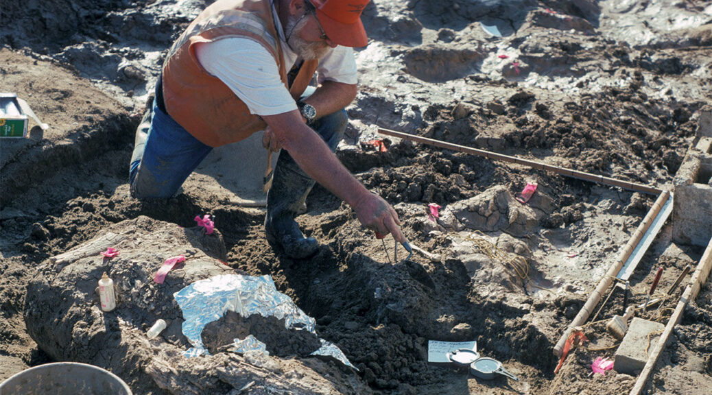
The discovery took place in 1992 by museum paleontologists, who were doing routine work at a freeway expansion in San Diego County. The site was named Cerutti Mastodon site, in honor of Richard Cerutti, who made the discovery and led the excavation.
Museum paleontologist Tom Deméré, who was involved in the excavation and has also been part of this study, said the project took five months and covered almost 600 square feet. He described the decades-long project as an “incredible odyssey.”
Researchers work at the Cerutti Mastodon site near San Diego.
“We early on realized that this is a special site,” said Deméré, adding later the group was “salvaging fossils as they were being found.”
Five large stones, which were used to break the bones and teeth of the mastodon, were found alongside the animal’s remains, according to the study. The site also contained fossils of other extinct animals, including dire wolf, horse, camel, mammoth and ground sloth.
Scientists specialized in various fields, from archaeology to the environment, have done research at the Cerutti site since its discovery.
Advanced radiometric dating technology allowed scientists to determine the mastodon bones belong to the Late Pleistocene period, or 130,000 years old, with a margin of error of plus or minus 9,400 years.
Some of the Mastodon bones found at the excavation site are seen in an image
“The bones and several teeth show clear signs of having been deliberately broken by humans with manual dexterity and experiential knowledge,” Holen said in a press release.
Experts agreed that the earliest records of human ancestors in North America is about 15,000 years old, but the discovery of the Cerutti site “shows that human ancestors were in the New World ten times that length of time,” said paleontologist Lawrence Vescera.
“This site really nails it because the evidence is really clear.”
The 11 scientists involved in the study told CNN it’s too early to tell the impact of the new findings. For now, they want the general audience to see it and understand it, and for their peers to study it — and even challenge it.
The archaeological treasures found at the Cerutti site will be on display at the San Diego museum. And a partnership with the University of Michigan will allow for even more people to see 3-D models of some of the specimens at their Online Repository of Fossils.
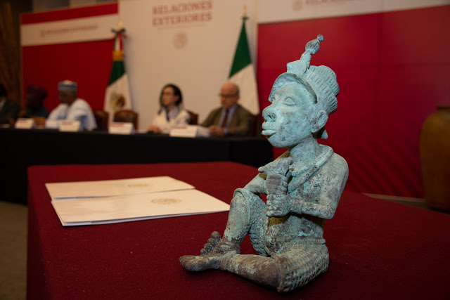
Mexican Government Returns Stolen Bronze Sculpture to Nigeria
Mexican customs officials thwarted an attempt to smuggle the ancient Yoruba sculpture into the country.
Mexico returns a smuggled bronze sculpture to Nigeria ?? after it was seized by customs officials at an airport. The Yoruba artefact is believed to date back to the 6th Century.
The Mexican government has recently returned a stolen bronze sculpture to Nigeria according to Vanguard.
The ancient sculpture was seized by customs officials at Mexico City Airport following an attempt to reportedly smuggle the artefact into the country.
The bronze sculpture itself is thought to be a 6th-century relic from the southwestern Yoruba City of Ife and depicts a man in woven pants sitting cross-legged and holding an instrument.
While it is still unclear how the artefact was obtained in the first place, Mexico’s Deputy Secretary of Foreign Affairs Julián Ventura Valero says, “We oppose the illegal commercialisation of archaeological pieces, an important cause of the impoverishment of the cultural heritage of the nations of origin, since it undermines the integrity of cultures and, therefore, of humanity.”
Several bronze artefacts ranging from a 19th-century cockerel from Benin City to an 18th-century Ethiopian crown have since been returned to their respective countries over the past few years.
Often the result of looting during the colonial era, the governments of these African countries are now rightly demanding that these stolen pieces of significant cultural history be permanently returned to them and not offered on “long-term loans” as has often been the case.
However, thousands more of these invaluable artefacts from many African countries remain housed in museums across Europe. Revisit our interview with anthropologist and curator Niama Safia Sandy about the politics around the repatriation of African art here.
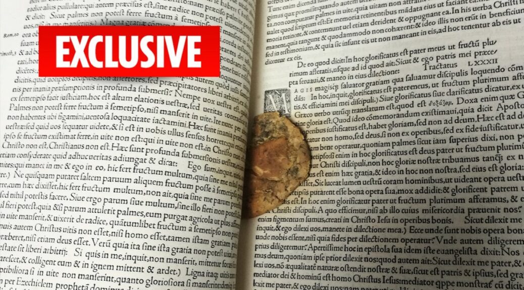
Half-Eaten Cookie Found Inside 16th Century Tudor Manuscript
One timid schoolboy is believed to be leafing through the book which seems to be a chocolate chip cookie about 50 years ago. The manuscript — which dates back almost 500 years — was given to the university by a grammar school in 1970.
The 1529 volume from the complete works of St Augustine is stored inside the university’s rare books archive, where no food, drink or even pens are allowed.
Emily Dourish, the deputy keeper of rare books and early manuscripts, discovered the biscuit.
She explained to The BBC: “It was probably a schoolboy looking at the book over 50 years ago who then accidentally dropped a biscuit and it was forgotten about.”
“When we received the book, somebody will have had a brief look at it, then stored it away. Nobody has properly looked at it since.”
“I was stunned. When we gave it to our conservationist, his jaw dropped.”
Restorers were able to remove the decaying “dry and crumbly” biccie — but it has left a greasy stain on a handwritten page.
The university’s special collections library tweeted: “For future reference, we have an acid-free paper to mark your place. Please don’t use baked goods.”
Archaeologists in Turkey Discover a Mysterious Ancient Kingdom Lost in History
In Southern Turkey Last Winter, a local farmer stumbled over a large stone half submerged in a canal of irrigation with mysterious inscriptions.
A local farmer discovered this stone half-submerged in an irrigation canal in Turkey. Inscriptions on the stone, dating back to the 8th century B.C. told the story of an ancient lost civilization in Turkey.
Accordingly to new discoveries, the stone revealed the existence of an ancient, lost civilization that might have defeated King Midas’ kingdom of Phrygia in the late eighth century B.C., according to new findings.
The farmer tipped the nearby archaeologist to the presence of the stone a few months after this discovery.
“Right away it was clear it was ancient, and we recognized the script it was written in: Luwian, the language used in the Bronze and Iron Ages in the area,” James Osborne, an archeologist and assistant professor of Anatolian Archeology at the University of Chicago, said in the statement. With a tractor, the farmer helped the archeologists pull the heavy stone block, or stele, out from the canal.
The stele was covered in hieroglyphs written in Luwian, one of the older Indo-European languages, according to the statement. The written language, made up of hieroglyphic symbols native to ancient Turkey, is read in alternating sequences from right to left and left to right.
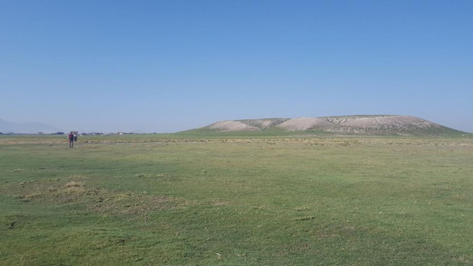
The newly discovered city likely had its capital located at Turkmen-Karahoyuk, an archeological mound in southern Turkey (shown here).
“We had no idea about this kingdom,” Osborne said. “In a flash, we had profound new information on the Iron Age Middle East.” The stone tells the story of an ancient kingdom that defeated Phrygia, which was ruled by King Midas. According to Greek mythology, Midas turned everything he touched into gold.
A symbol on the stone indicated that it was a message that came directly from its ruler, King Hartapu. One part of the stone read, “The storm gods delivered the [opposing] kings to his majesty.”
The lost kingdom likely existed between the ninth and seventh centuries B.C. and at its height, it likely covered around 300 acres (120 hectares). Though that sounds tiny compared with modern cities, it was actually one of the largest settlements to exist in ancient Turkey at the time.
The name of the kingdom is unclear, but its capital city was likely located at what is now the nearby archeological site of Turkmen-Karahoyuk.
The Konya Regional Archaeological Survey Project had identified this settlement as a major archeological site in 2017, and Osborne and his colleagues had been excavating there at the time when the stone was discovered.
This inscription isn’t the first mention of King Hartapu. Just under 10 miles (16 kilometers) south, archeologists previously discovered hieroglyphic inscriptions on a volcano that referred to King Hartapu. That inscription didn’t reveal who he was or what kingdom he ruled, according to the statement.
Remembering the giant mushrooms that once ruled the earth
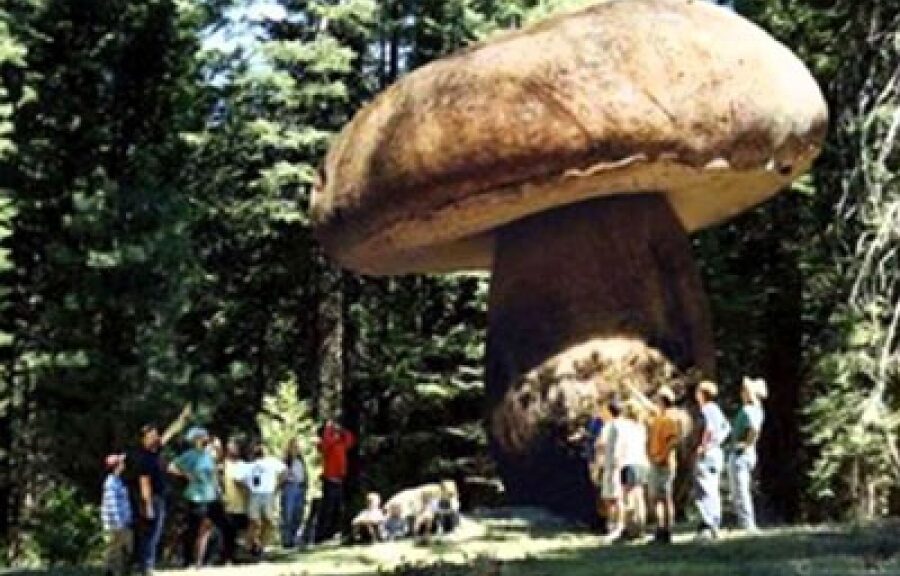
When earth plants were relatively new kids and “the largest trees only a few meters high” on the evolutionary block from around 420 to 350 million years ago, giant spires of life poked from the Earth.
“The ancient organism boasted trunks up to 24 feet (8 meters) high and as wide as three feet (one meter),” said National Geographic in 2007. With the help of a fossil dug up in Saudi Arabia scientists finally figured out what the giant creature was: a fungus. (We think.)
The towering fungus spires would have stood out against a landscape scarce of such giants, said New Scientist in 2007.
“A 6-meter fungus would be odd enough in the modern world, but at least we are used to trees quite a bit bigger,” says Boyce.
“Plants at that time were a few feet tall, invertebrate animals were small, and there were no terrestrial vertebrates. This fossil would have been all the more striking in such a diminutive landscape.”
Fossils of the organisms, known as Prototaxites, had peppered the paleontological findings of the past century and a half, ever since they were first discovered by a Canadian in 1859.
But despite the fossil records, no one could figure out what the heck these giant spires were. The University of Chicago:
Digging up a Prototaxites fossil (University of Chicago)
For the next 130 years, debate raged. Some scientists called Prototaxites a lichen, others a fungus, and still others clung to the notion that it was some kind of tree.
“The problem is that when you look up close at the anatomy, it’s evocative of a lot of different things, but it’s diagnostic of nothing,” says Boyce, an associate professor in geophysical sciences and the Committee on Evolutionary Biology. “And it’s so damn big that when whenever someone says its something, everyone else’s hackles get up: ‘How could you have a lichen 20 feet tall?’”
That all changed in 2007 when a study came out that concluded the spires were a fungus, like a gigantic early mushroom.
But not everyone was sold on the idea that Prototaxites was an early fungus. No one’s questioning the spires’ existence—people just have trouble trying to imagine that such a huge structure could be a fungus.
Researchers trying to refute the fungus idea thought that Prototaxites spires were gigantic mats of liverworts that had somehow rolled up. But in a follow-up study, the scientists who had proposed the fungus idea doubled down on their claim.
So science is messy, and despite more than a century of digging, we still don’t really know, for sure, what these huge spires that dominated the ancient Earth really were.
But even though the spire-like mushrooms of yore—or whatever they were—are long gone, don’t feel too bad for fungus kind. The largest organism on Earth, says ABC, is still a huge fungal mat, a single organism spread over 2,200 acres of forest in eastern Oregon.
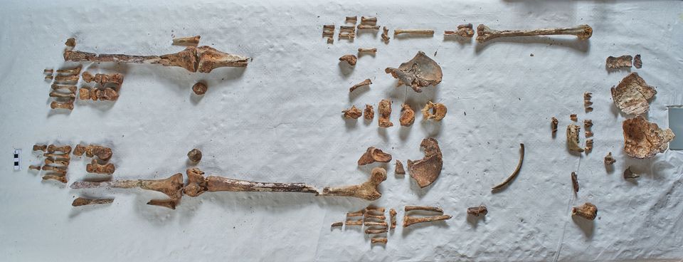
Bones hidden in church revealed to be remains of one of England’s earliest saints
First scientific tests on bones in a Kent Church for decades prove they are really are relics of one of the earliest English saints, Eanswythe, patron saint of Folkestone.
Apart from one bone fragment and a single tooth sent for radiocarbon to Queen’s University Belfast, the remains stayed in the church during the work
She was a Kentish royal Anglo-Saxon princess who is said to have founded one of the earliest English monastic communities as a teenager but died in her teens or early 20s.
If the findings of further studies are authenticated, hers are the earliest identified remains of an English saint, and the only remains identified of a member of the powerful Anglo Saxon royal family.
Eanswythe cannot have been born any later than 641 AD since her father king Eadbald died in late 640. She is believed to have died by 663. The radiocarbon dating results, which would indicate the latest date of her death, give a high probability that the bones date from between 649 and 673 AD.
“My hands were literally shaking when I opened the email with the results,” says Andrew Richardson, the archaeologist who led the Finding Eanswythe project. “The dates could have been inconclusive, or blown the project completely out of the water, but instead they are the best we could possibly have hoped for.”
Workmen found the relics in 1885, hidden inside a wall near the altar
The diocese of Canterbury gave special permission for the work on the bones, which were examined by archaeologists in the 1980s but not tested.
Apart from one bone fragment and a single tooth sent for radiocarbon to Queen’s University Belfast, they stayed in the church during the work, with the archaeologists and scientists sleeping in the church to guard them.
Most of the team including Richardson come from Folkestone and had known the story of the teenage saint since childhood, apart from US-born conservator Dana Goodburn-Brown who is still working on fragments including minute scraps which may be the gold thread from precious fabric once covering the bones.
The relics had disappeared for centuries before workmen found them in 1885, hidden inside a wall near the altar, presumably to save them from the iconoclasm of the Reformation, which destroyed most of the oldest monuments.
They were still in a curious battered oval lead container, one of a handful of known Anglo Saxon examples made from recycled panels cut down from a high status decorated Roman coffin. They have remained where they were reinterred in 1885, in a niche behind an alabaster and brass fronted door, part of an elaborate Victorian redecoration of the church.
Archaeologists and scientists slept in the church to guard the relics
Eanswythe’s grandfather Ethelbert was the first English king to convert to Christianity, under the mission to Kent of Saint Augustine: his tomb and others of the royal family were destroyed with Augustine’s church in Canterbury.
She is said to have founded a monastic settlement, near the present medieval church of St Mary and St Eanswythe which stands on the cliff above the sea high above the old town of Folkestone.
Early accounts of her life say her body was moved when some monastic buildings tumbled over the cliff into the sea and moved again when the new church was built.
In a 13th century life, she was credited with some admirably practical miracles, illustrated in Victorian stained glass in the church, including diverting a stream to flow uphill to supply her monastery, and ordering a flock of birds to spare their crops.
The Anglo Saxon history of the area will be celebrated in events at the nearby town museum during British Science Week from 6-15 March. The Finding Eanswythe project is fundraising for further tests, which the team hopes will include extracting DNA which should reveal more about her diet, background, and appearance.