Hittite Prince’s Seal and Cuneiform Tablet Uncovered in Turkey
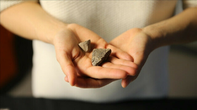
A 3,250-year-old seal belonging to a Hittite prince and an ancient cuneiform tablet dating back 3,400 years were discovered in Turkey’s southern Hatay province.
The excavations in Accana Hoyuk of the Reyhanli district in Hatay on behalf of the Culture and Tourism Ministry with the support of the Turkish Historical Society, have been underway for six months.
Speaking to Anadolu Agency, Murat Akar, the head of the excavation team and Mustafa Kemal University’s Protohistory and Near East Archeology Department chair, said they have had some “thrilling” findings.
An ancient tablet they have unearthed has Akkadian cuneiform texts, Akar noted, saying: “The tablet, around 3,400 years old, and the accompanying cylinder seals give us information about the administration and administrative practices of the region, especially during a period when the region was under the rule of the Mitanni Empire.”
He said they had found a 3,250-year-old seal during the latest excavation, adding that the item is one of the most important discoveries of this year, helping us understand “what happened during the period after the region came under the Hittite control” as well as “define its administrative and political dynamics.”
Akar further noted that the findings provide information about the administrative and archival practices in the Alalakh ancient city, the capital of the Mukish Kingdom in the Middle and Late Bronze Age.
“The written documents we found are extremely exciting,” he said.
The impressions on the cylinder seals show the existence of a ruling class in the region, Akar said, adding: “This last one, with Luwian hieroglyphic inscription on it, gives us the name of a Hittite prince whose name is not included in other written documents in Alalakh and appears for the first time.”
He did not reveal the name of the Hittite prince but said a Hittitology academic at Istanbul University Faculty of Letters, Hasan Peker, will share the name of the prince with the scientific community once the research is completed.
Four Of North America’s Oldest Human Skulls Don’t Look Much Alike
The earliest humans in North America were far more diverse than previously realized, according to a new study of human remains found within one of the world’s most extensive underwater cave systems.
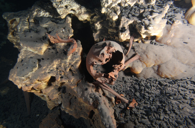
The original position of the skeletal remains inside the submerged cave of Muknal. These remains date back to about 10,000 years ago and belonged to an adult male.
The remains, discovered in the caverns of the Mexican state of Quintana Roo, represent just four of the earliest North Americans, all of whom lived between 9,000 and 13,000 years ago. They’re important because North American remains from the first millennia of human habitation in the Americas are rare, said study leader Mark Hubbe, an anthropologist at The Ohio State University. Fewer than two dozen individuals have been discovered, he added.
What makes the four individuals from Mexico interesting is that none of them is quite alike. One resembles peoples from the Arctic, another has European features and one looks much like early South American skulls, while the last doesn’t share features with anyone population.
“The differences we see among these Mexican skulls are on the same magnitude as the most different populations nowadays,” Hubbe told Live Science.
The settlement of the Americas is a complicated topic, shrouded in mystery because of the dearth of archaeological findings from 15,000 to 20,000 years ago, which is probably when the first humans set foot on the continent. South America has more early human remains than North America, Hubbe said. The skulls found in South America are typically quite similar to one another, sharing features of skull measurements with indigenous Australians and Africans.
This doesn’t mean that the South Americans had ancestors who came directly from Australia or Africa, Hubbe cautions. Rather, the shared features reveal a shared common ancestry between ancient South Americans and the peoples of Australia and Africa.
“The [skull] morphologies in Asia changed a lot in the last 10,000 years,” Hubbe said. “Everyone who came [to the Americas] before 10,000 years ago would look a lot like early modern humans out of Africa and Australia.”
Because the path to South America must have included pit stops in North America or along the Pacific coast, the assumption has long been that early people in South America looked a lot like early people in North America. But the new research suggests otherwise, Hubbe said. Instead, early North American populations look far more diverse than early South American populations.
“For whatever reason, when they went to South America, part of this diversity disappeared,” Hubbe said.
The extensive caves of Quintana Roo are now mostly underwater. But about 12,000 years ago, during the end of the Pleistocene epoch and the beginning of the Holocene, sea levels were lower and the caves were dry. Some of the early inhabitants of Mexico seemed to use the caves as burial places, deliberately placing bodies inside. Some other skeletons discovered in the caves appear to indicate that those people’s deaths may have been accidental.
Of the four skulls studied in the new research, published today in the journal PLOS ONE, one came from a young adult woman who lived around 13,000 years ago; one belonged to a young adult male from the same era; one was from a middle-aged woman who lived between about 9,000 and 12,000 years ago, and the fourth was that of a middle-aged man from around 10,000 years ago. Hubbe and his co-authors used computed tomography (CT) scanning to re-create digital, 3D images of the skulls. They then marked various landmarks on the skulls, such as the bottom of the nose or top of the eye orbits. Sizes and distances between landmarks were then used to compare the skulls to larger data sets of measurements from different populations of people around the world.
The four skulls, from cenotes (sinkholes) in the Mexican state of Quintana Roo, analyzed in the study.
There are limitations to working with the data of only four people, Hubbe said – after all, any given individual can be an outlier compared with the rest of his or her community. But, in an attempt to downplay any individual quirks of the skulls, the researchers focused only on the components of the measurements that explained the majority of the variations between skulls. By limiting the analysis to only major variations, they could avoid putting too much weight on smaller differences between skulls.
They found that the 13,000-year-old young woman had features that most closely matched Arctic North Americans from Greenland and Alaska. The young man from 13,000 years ago, on the other hand, looked most similar to people from European populations. The middle-aged female from between 9,000 and 12,000 years ago looked much like the earliest settlers of South America. Finally, the middle-aged man from around 10,000 years ago showed no clear pattern. He had features seen in several American and Asian populations.
The findings are important because they provide new information on the earliest Americans, said Richard Jantz, an anthropologist at the University of Tennessee who was not involved in the research. The skulls are diverse, he said, though he noted that all but the young man from 13,000 years ago had Asian or Native American affinities, so the differences shouldn’t be overexaggerated.
The new information complicates the fuzzy picture of who the first Americans were and how the earliest migrations worked.
North America could have been more diverse than South America if there were a consistent flow of people – and new genes – into North America, but only one or two big movements of populations through the funnel of Mexico into South America, Hubbe said.
“We cannot test this at this point,” he said.
That story also contradicts the genomic data researchers have collected. Genomics suggests that all Native Americans (with the exception of a few later migrants) descend from a single migration of people from Asia. But research-based on phenotype – the way people looked – suggests multiple migration events, creating a population that got regular injections of diversity.
“I think if America consisted of a homogenous population 10,000 or 15,000 years ago, that drawing skulls at random from it would not produce as much variation as you see,” Jantz said.
In today’s humans, Jantz said, genomics data and skull shape data generally mesh well — people with similar ancestry tend to show similarities in their skull measurements. So far, the same does not seem to be the case for the earliest Americans. But there are limitations in data on both the genetic and the archaeological sites, Jantz said. Genomics researchers have only three ancient DNA samples from North America, and modern Native Americans’ genetic profiles have been complicated by genocide and mixture with Europeans. Researchers who study skull morphology have only a handful of bones to work with, as well.
“To me,” Jantz said, “the biggest challenge is reconciling conflicting lines of evidence.”
Long-Hidden “Pyramid” Found in Indonesia Was Likely an Ancient Temple
When Dutch colonists became the first Europeans to discover Gunung (Mount) Padang in the early 20th century, they must have been awestruck by the sheer scale of their ancient stone surroundings.
Here, scattered across a vast hilltop in the West Java province of Indonesia, lay the remnants of a massive complex of rocky structures and monuments – an archaeological wonder since described as the largest megalithic site in all of Southeastern Asia.
But those early settlers couldn’t have guessed the greatest wonder of all might lay hidden, buried deep in the ground below their feet.
In controversial new research presented at the AGU 2018 Fall Meeting in Washington, DC, last week, a team of Indonesian scientists presented data to make their case that Gunung Padang is in fact the site of the world’s oldest known pyramid-like structure.
Their research, which has been conducted over the course of several years, suggests that Gunung Padang is not the hill we think it is – but is actually a layered series of ancient structures with foundations dating back some 10,000 years (or even older).
“Our studies prove that the structure does not cover just the top but also wrap around the slopes covering about 15 hectares area at least,” the authors write in the abstract for their new poster.
“The structures are not only superficial but rooted into greater depth.”
Using a combination of surveying methods – including ground penetration radar (GPR), seismic tomography, and archaeological excavations – the team says Gunung Padang is not just an artificial structure, but a series of several layers built over consecutive prehistoric periods.
The topmost, megalithic layer made up of rock columns, walls, paths, and spaces sit above a second layer some 1-3 metres below the surface.
The researchers suggest this second layer has previously been misinterpreted as natural rock formation but is actually another arrangement of columnar rocks organised in a matrix structure.
Below this, the third layer of arranged rocks – containing large underground cavities or chambers – extends as far as 15 metres deep, and this sits upon the lowest (fourth) layer, made of ‘lava tongue’ basalt rock, somehow modified or carved by human hands.
According to the researchers, preliminary radiocarbon dating suggests the first layer could be up to approximately 3,500 old years old, the second layer somewhere around 8,000 years old, and the third layer in the vicinity of 9,500 to 28,000 years old.
As for the purpose of these ancient, vast structures, the researchers – led by geophysicist Danny Hilman Natawidjaja from the Indonesian Institute of Sciences – suggest the ancient pyramid could have had a religious basis.
“It’s a unique temple,” Natawidjaja told Live Science.
For now, that’s speculation, but if the researchers’ other claims about the structures turn out to be right, it’s a major finding that could challenge notions of what prehistoric societies were capable of.
‘It’s huge,” Natawidjaja told The Sydney Morning Herald in 2013. ”People think the prehistoric age was primitive, but this monument proves that wrong.”
Still, not everybody is convinced. Natawidjaja’s research has been the subject of much controversy in Indonesia and elsewhere, with a large number of archaeologists and sceptics criticising the team’s methods and findings.
The latest research presentations – which, for now, remain non-peer-reviewed – will probably add fuel to the fire, but they also give the world a closer glimpse at what could be one of the world’s most ancient and mysterious structures.
As for what that structure really is, only time will tell.
8,000 years of history to resurface at Turkey’s Tavşanlı Mound
Excavations set to start at a mound in the central Turkish province of Kütahya in September are expected to shed light on 8,000 years of history, archaeologists said.
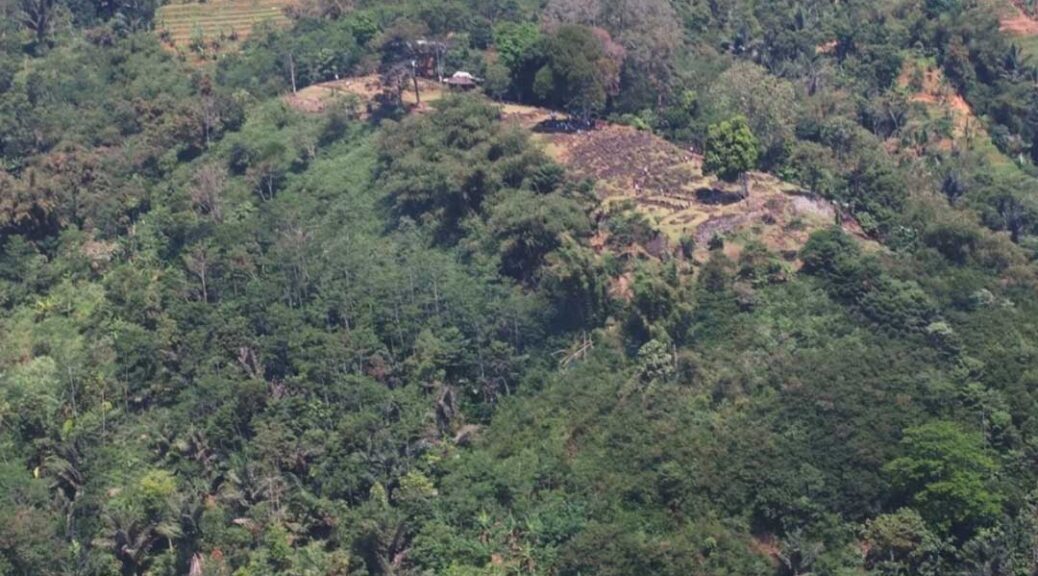
An aerial view of the Tavşanlı Mound, Kütahya, central Turkey.
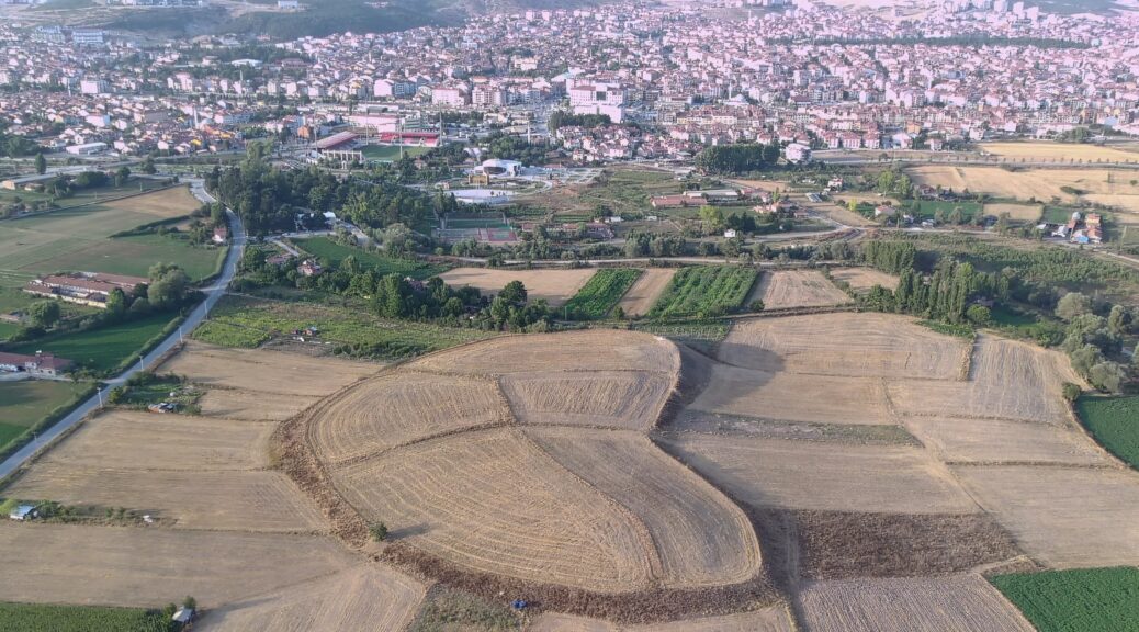
Dubbed the “Heart of Kütahya” over its shape detected through aerial footage, the “Tavşanlı Mound” located in the namesake district will be unearthed through the cooperation of the Ministry of Culture and Tourism and Bilecik Şeyh Edebali University (BŞEU), along with the support of the Tavşanlı Municipality.
Academics from Ankara University, Ankara Hacı Bayram Veli University, Hacettepe University, Istanbul University, Zonguldak Bülent Ecevit University and Uşak University will also take part in the excavations, to be headed by Erkan Fidan, a faculty member at the archaeology department of the BŞEU.
An aerial view from the Tavşanlı Mound, Kütahya, central Turkey.
The excavations were launched through a presidential decree and are expected to last some 30 years.
Sezer Seçer Fidan, a Hittitologist who is also in charge of the Tavşanlı Mound site, told Anadolu Agency (AA) that the mound was once one of the largest settlements in western Anatolia.
“While previous settlements here were a conglomeration of a couple of villages, as the swamps were filled and drained, it becomes a site that could serve as the basis for urbanization and turn into a capital city.
This corresponds roughly to (a period) four to 5,000 years earlier. Urbanization at this site of course does not consist of a single-phase, but a formation that continues to expand over time,” Fidan said.
Archaeologists work on the Tavşanlı Mound, Kütahya, central Turkey.
She explained that the goal for excavations during this year is to uncover city walls dating back to the Hittites and modern ages, which would prove the importance and scale of the Tavşanlı Mound.
Fidan noted that the mound might contain information, documents and findings on those who have lived in western Anatolia for the last 8,000 years.
“The settlement here lasted until the end of the Bronze Age; therefore, we can see a number of ages stratigraphically. Here, we both want to monitor transitions between civilizations and the exact importance of such a large mound spanning a hectare (in size). … If we can detect buildings related to the Hittite period, then we can find written documents or findings.
It would be a very important finding for western Anatolia since written documents are very rare in this region,” she noted.
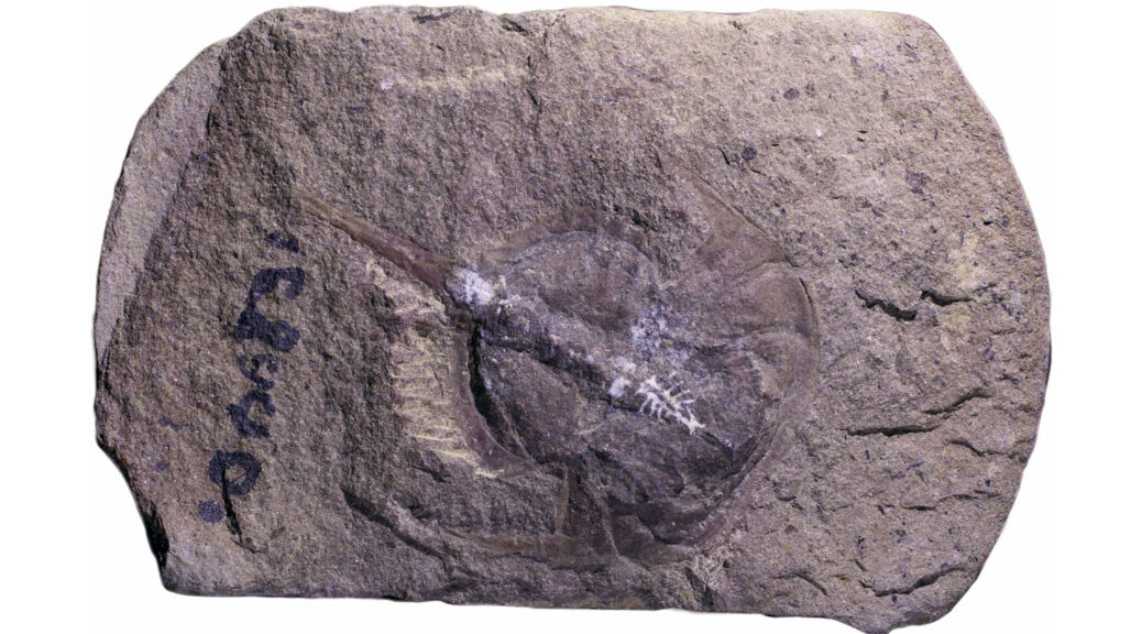
How fossilization preserved a 310-million-year-old horseshoe crab’s brain
Researchers have uncovered a never-before-seen fossilized brain from a 310 million-year-old horseshoe crab, revealing some surprises about the evolution of these wannabe crustaceans, according to a new study.
This fossilized horseshoe crab (Euproops danae), shown in the left image, held a perfectly preserved mold of its brain, shown close-up in panel B. Panel C shows a reconstruction of Euproops danae, including the position and anatomy of the brain.
The fossilized brain, which belongs to the extinct species Euproops Danae, was discovered at Mazon Creek in Illinois, where the conditions were just right to perfectly preserve the animal’s delicate soft tissue.
There are four species of horseshoe crabs alive today — all of which sport hard exoskeletons, 10 legs and a U-shaped head. Despite their name, these “crabs” are actually arachnids that are closely related to scorpions and spiders, according to The National Wildlife Federation.
Although horseshoe crab fossils are relatively common, nothing was previously known about their ancient brains, the researchers said.
“This is the first and only evidence for a brain in a fossil horseshoe crab,” lead author Russell Bicknell, a palaeontologist at the University of New England in Maine, told Live Science. The chances of finding a fossilized brain are “one in a million,” he added. “Although, even then, chances are they are even rarer.”
Soft tissues that makeup brains are very prone to rapid decay, Bicknell said. “In order for them to be preserved, either very special geological conditions, or amber, are needed.”
In this case, geology helped to keep the soft tissue in tip-top condition over the years and preserve the brain — or at least a copy of the brain. “We have a mould of the brain, not the brain itself, so to speak,” Bicknell said.
The deposits at Mazon Creek are made of an iron carbonate mineral called siderite, which forms concretions — mineral precipitations — that can quickly encase a dead body and fossilize it.
Although such concretions preserved the horseshoe crab’s body, the brain tissue still decomposed and eventually disappeared. However, as the brain rotted away it was replaced by a clay mineral called kaolinite, which created a cast of the brain.
Kaolite is white in colour, whereas siderite is dark grey. This colour contrast meant the brain fossil “stood out more than it would have normally” from the rest of the fossil, Bicknell said.
The hunt is now on for more ancient brains that might have been fossilized in the unique geological conditions that preserved this horseshoe crab.
“The Mazon Creek deposit is exceptional,” Bicknell said. “If we started looking, we may be lucky enough to find more [brain fossils].”
The discovery provided researchers with the unique opportunity to study how the arachnids’ brains evolved over time. But to the researchers’ surprise, they found that the ancient brain, which dates to the Carboniferous period (359 million to 299 million years ago), was remarkably similar to that of a modern horseshoe crab.
“Despite 300 million years of evolution, the fossil horseshoe crab brain is pretty much the same as modern forms,” Bicknell said.
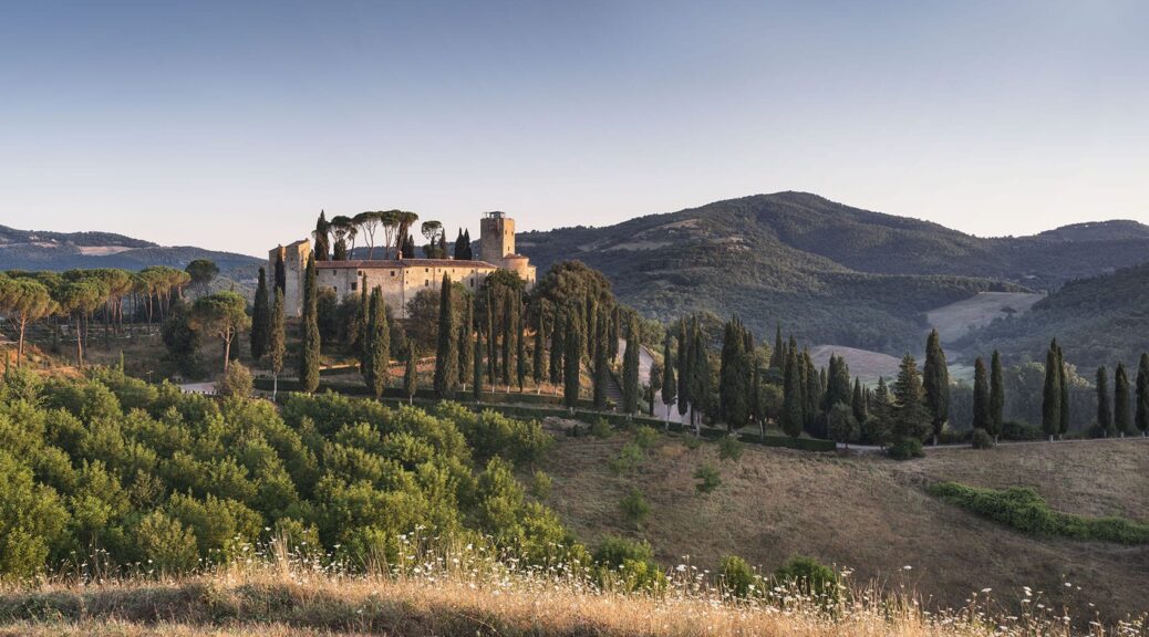
Bolza family turns 1,000-year-old Italian castle into Hotel Castello di Reschio
A 10th-century castle in the Umbrian hills has been restored and transformed into a hotel by Count Benedikt Bolza and his family, who created custom furniture for its 36 suites, restaurant and spa.
Welcoming its first guests in spring 2021, Hotel Castello di Reschio comprises 30 suites within the historic castle. The hotel sits within the sprawling Reschio estate, which was acquired by Count Antonio Bolza in 1994, lies on the border between Umbria and Tuscany and is dotted with farmhouses.
The crumbling buildings were slowly restored into private homes by his son Benedikt and daughter-in-law Donna before they turned their attention to the site’s impressive 1,000-year-old castle and surrounding structures.
The family lived in the stone “Castello” for a decade while they worked to protect and restore the architecture, then create interiors that respect the ancient building while offering modern comforts.
In total 30 suites were built within the castle itself, with some rooms having views of the central courtyard garden, while others look out over the rolling hills.
A further six suites were built next to the parish church.
All of the rooms were decorated with terracotta-brick or wooden floors, hand-stitched linen curtains, Italian fabrics, and locally crafted marble and brass vanities.
Benedikt Bolza also designed and crafted bespoke beds and lighting for the hotel via his own furniture brand, BB for Reschio. These are mixed with portraits, photos and other curios sourced from local antique markets.
“Benedikt has embraced an organic approach to the design, championing local craftsmanship and creating thoughtful, whimsical spaces that are filled with comfort and wit, while artfully nodding to the fascinating characters who once resided within the castle walls,” said the family.
The Tower Suite, which is entered over the castle’s gateway and spread over five levels, boasts two bedrooms, a living room, a study, and a roof garden with an open-air bathtub.
Dining options for guests include the Ristorante Al Castello, located in the castle’s western ramparts and serving Italian dishes made with produce grown on the estate.
The verdant Palm Court is a new structural addition modelled on iron-and-glass Victorian conservatories, which is intended as a space for reading, conversation or enjoying cakes and cocktails from the adjacent bar.
Another alternative is Il Torrino, the converted watchtower that serves light fare and drinks, and overlooks an oval swimming pool.
The hotel spa is situated in the vaulted stone cellar, where hammams, saunas and plunge pools are atmospherically lit by shards of sunlight through the arrow slits and windows.
Guests seeking a more active experience can explore the estate on foot or bicycle, or take horse-riding lessons at the Equestrian Centre. Many of the region’s historic towns and cities are also a short drive away, for those who wish to explore further afield.
Castles and ancient buildings across Italy have been converted into guest accommodation while maintaining their original charm and character.
Another example, also in Umbria, is a 12th-century watchtower that was reconstructed and turned into a holiday retreat.
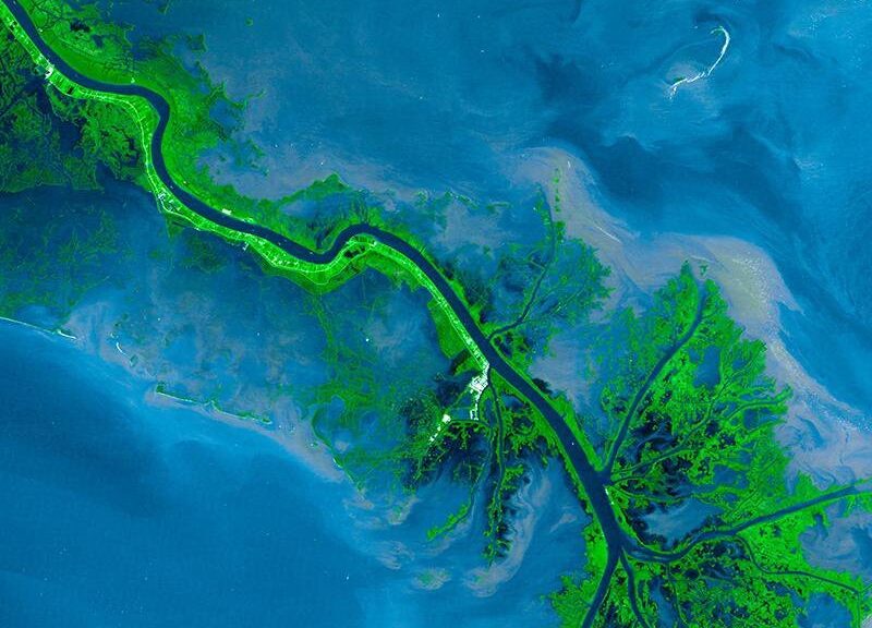
The 70 Million-Year-Old History of the Mississippi River
In 1758, the French ethnographer Antoine-Simon Le Page du Pratz published The History of Louisiana, in which he wrote that the Mississippi River’s name meant “the ancient father of rivers.” Though his etymology was off—the Ojibwe words that gave us Mississippi (Misi-ziibi) actually mean “long river”—the idea has proven durable. “Ol’ Man River” buoyed Show Boat, the 1927 musical by Jerome Kern and Oscar Hammerstein II.
The Mississippi Delta, seen from space in 2001.
During the 1937 flood, Raymond Daniell wrote in the New York Times about frantic efforts to raise barriers “faster than old man river could rise.”
Now it appears that the Mississippi is far older than Le Page thought, and it used to be far bigger than the Ojibwe could have imagined. And it might even become that big again in the future.
These are the extraordinary new findings unearthed by geologists including Sally Potter-McIntyre at Southern Illinois University, Michael Blum at the University of Kansas and Randel Cox at the University of Memphis, whose work is helping us better understand the monumental events, beginning in late Cretaceous North America, that gave rise to the Mississippi, swelling it to gargantuan proportions.
An 1832 expedition led by Henry Schoolcraft identified the Mississippi’s source as Lake Itasca in Minnesota.
In the late Cretaceous, around 80 million years ago, a mountain chain spanned the southern portion of the continent, blocking southbound water flows, so most North American rivers flowed to the Western Interior Sea or north to Canada’s Hudson Bay.
Eventually, a gap in those mountains formed, opening a path for the river we now know as the Mississippi to flow to the Gulf of Mexico. Scientists call that gap the Mississippi Embayment, but the rest of us know it as the Mississippi Delta, the vast flood plain that stretches from southern Missouri to northern Louisiana.
As recently as 2014, geological consensus held that the Mississippi began flowing through the embayment around 20 million years ago. But in 2018, Potter-McIntyre and her team concluded, based on the age of zircon fragments they excavated from sandstone in southern Illinois, that the river began flowing much earlier—some 70 million years ago.
The Mississippi was thus born when dinosaurs still roamed the planet; one can almost picture an alamosaurus bending its prodigious neck to drink from its waters. By contrast, the Missouri River, in its current form, dates back a mere two million years. Old Man River, indeed.
Still, 70 million years ago the Mississippi was nowhere near as large as it would become. Blum has detailed how the waterway grew as it added tributaries: the Platte, Arkansas and Tennessee rivers by the late Paleocene, then the Red River by the Oligocene.
Around 60 million years ago, the Mississippi was collecting water from the Rockies to the Appalachians; by four million years ago, its watershed had extended into Canada, and the Mississippi had grown to an enormous size, carrying four to eight times as much water as it does today, Cox and colleagues have found. “This was a giant river, on the order of the Amazon,” said Cox.
So the river’s larger-than-life role in culture was perhaps inevitable. Until the early 19th century, the Mississippi marked the western border between Spanish and American territory, and it continues to give life to the cities that sprang up along its route.
After Union forces captured Vicksburg, Mississippi, in 1863, President Abraham Lincoln saw the emancipated river as a symbol of a nation unified: “The Father of Waters again goes unvexed to the sea,” he wrote.
Mark Twain, the best publicist a river ever had, inspired 150 years’ worth of dreams about floating away from our troubles. And among members of the Ojibwe, Dakota and Chitimacha tribes, who still live on portions of ancestral lands in the Mississippi Valley, a spiritual connection to the river remains strong.
In 2013, Nibi Walk, a group of Indigenous women walked 1,500 miles along the Mississippi to advocate for clean water—an issue of vital importance to the 18 million Americans who get their drinking water from the river.
The river’s famed fluctuations have shaped American urbanization, too. The Great Flood of 1927 accelerated the Great Migration, as African Americans, disproportionately displaced, sought economic opportunity in cities such as Chicago and Detroit.
“Old Mississippi River, what a fix you left me in,” Bessie Smith sings in “Homeless Blues,” one of many songs about the 1927 flood. That disaster also ushered in an era of unprecedented public works, as the federal government sought to remake the river into a predictable route for moving bulk necessities like corn and coal.
The mighty river has inspired more than a thousand songs since 1900, including “Big River” by Johnny Cash and “Proud Mary,” in which John Fogerty (echoed later by Tina Turner) observes that “people on the river are happy to give.” That truism is confirmed every year when people who live along the Mississippi offer a meal and a shower to the dozens of strangers who test themselves against Old Man River by paddling small boats from Minnesota to the Gulf of Mexico.
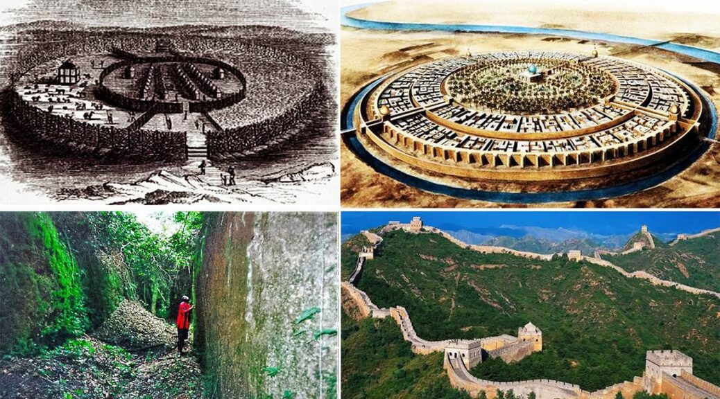
Ancient Walls of Benin Were Four times longer than walls of china
In Benin, the capital city of present-day Edo State stood the walls of Benin (800 – 1400AD) which are the longest ancient earthworks in the world and apparently the largest man-made structure on earth.
The walls are a set of earthworks comprising of banks and ditches called Iya in the native tongue. It comprises 15 kilometres (9.3 miles) of “Iya” (banks and ditches) city and an estimated 16,000 kilometres (9,900 miles) in the rural areas surrounding Benin.
As at that time, with its enormous length, it was speculated to be double the length of the Great Wall of China, until it was declared in the year 2012 (after five years of thorough measurement by Chinese surveyors) that the Great Wall has a length of around 21, 0000 km.
The time of construction is not precisely known which gives it different assumptions as to the date
First view: Graham Connah predicted the walls may have been built between the thirteenth and mid-fifteenth century CE.
Second view: Patrick Darling predicted the walls of Benin (in the Esan region) may have been built during the first millennium CE.
How the walls were built
The walls were built with a ditch and dike arrangement. The ditch was bored to form an inner moat with the excavated earth used to create the exterior rampart.
Remains
The Walls of Benin were destroyed by the British in 1897 during the named Punitive expedition. Disjointed pieces of the wall remain in Edo, with a large proportion of them being used by the residents for construction purposes. The little that remains of the wall is continually demolished for real estate developments.
Fred Pearce in an article in the New Scientist (September 11th 1999) said “They extend for some 16,000km in all, in a mosaic of more than 500 interconnected settlement boundaries.
They cover 2, 510 sq. miles (6, 500 square kilometres) and were all dug by the Edo people. In all, they are four times longer than the Great Wall of China and consume a hundred times more material than the Great Pyramid of Cheops.
They took an estimated 150 million hours of digging to construct, and are perhaps the largest single archaeological phenomenon on the planet.”
An ethnic mathematician named Ron Eglash explained the planned blueprint of the city using fractals at the ground level, not just in the city, also in the villages and in the rooms of houses.
He stated that “When Europeans first came to Africa, they considered the architecture very disorganised and thus primitive. It never occurred to them that the Africans might have been using a form of mathematics that they hadn’t even discovered yet.”
The walls of Benin were famously described by the Guinness Book of Records (1974 edition) as being “the world’s largest earthworks prior to the mechanical era.”
Also, Benin city was in the league of the first cities to have a likeness of street lighting with large metal lamps, a large number of feet high, built and placed around the city.