Pre-Roman Prince’s Tomb Packed With Treasures Found in Italy
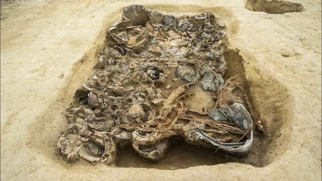
In a recently uncovered Iron Age cemetery in central Italy, archaeologists have found the remnants of an entire iron-wheeled war chariot, a recent study finds. The lavish tomb is also brimming with other riches, including a stash of weapons, a bronze helmet and vessels made of bronze and clay.
An archaeologist cleans the bronze helmet found in the Iron Age burial.
The body of the chariot’s owner, however, is long gone.
The person, possibly a man, based on the war-related grave goods — was likely buried under a large mound of dirt that rose above the ground like a giant gumdrop, at the time of burial.
The rich assemblage of grave goods indicates that the person buried here held a high status.
If his body was placed near the surface, “it would have had little chance of surviving the centuries of subsequent ploughing that have removed all traces of any above-ground mound,” study researcher Federica Boschi, a senior assistant professor of methods of archaeological research at the University of Bologna in Italy, wrote in the study.
But even though the body is missing, the treasures in this 2,600-year-old grave reveal much about this mystery man, Boschi said.
The “extraordinary collection of cultural material” is “unequivocal testimony to the aristocratic status of the tomb’s owner,” Boschi told Live Science in an email.
The burial goods are so swanky, she began referring to the site as the “princely tomb,” Boschi said.
The maps (top left) show where the burial was discovered. An aerial survey (top right) shows the crop marks that clued archaeologists into the discovery. Finally, the bottom map shows the crop circles in red.
Digging deep
Archaeologists found the burial while surveying the land prior to the construction of a new sports complex in the Nevola River Valley. An aerial survey over the town of Corinaldo revealed evidence of the grave.
Researchers excavate the Iron Age site at Corinaldo, Italy.
This bird’s-eye view showed the remains of large, circular ditches. This seemed peculiar, so Boschi and her colleagues began doing the groundwork.
At first, they used electrical resistance, which puts electrical currents into the ground and monitors for anomalies in how current flows through the soil. The team also used magnetic surveys to detect if any metal artefacts were lurking underground.
These surveys hinted that something was buried under the ditches. Soon after the archaeologists began digging, they found the tomb and its treasures, Boschi said.
She noted that the grave is surrounded by a 98-foot-wide (30 meters) circular moat, which may have had that gumdrop-like mound over it at the time of the burial. The tomb itself is smaller, measuring 10.5 by 9 feet (3.2 by 2.8 m).
The tomb dates to the seventh century B.C., so it likely belonged to the Piceni culture, a group of Iron Age people who lived along the Adriatic coast of Italy.
Evidence, including the artefacts from this burial, indicate that the Piceni were warlike, according to Encyclopedia Britannica. In 268 B.C., Rome annexed their land.
A bronze bucket (known as a situla), a bundle of iron skewers and pieces of the chariot wheels.
It’s a “rare event” to find such an opulent grave from the Iron Age, Boschi said. Its grave goods, size and the fact that it was once likely covered with an earthen mound “speak to us about a Piceni leader, a person which gathered political, military and economic power,” she said.
Going forward, archaeologists plan to study the hundreds of objects within the burial.
Greek Farmer Stumbles Onto 3,400-Year-Old Tomb Hidden Below His Olive Grove
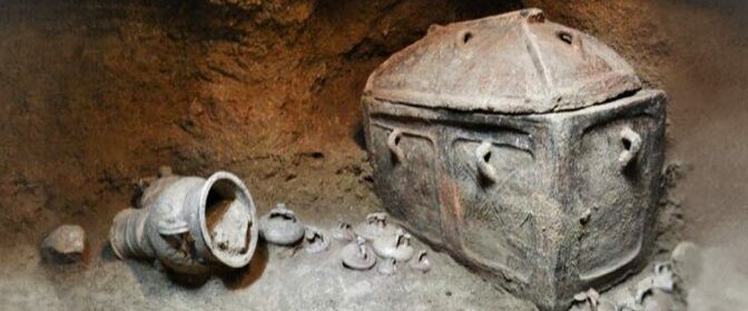
Unbeknownst to a Greek farmer, a 3,400-year-old tomb containing two coffins and dozens of artefacts dating back to the Late Minoan era had been lying beneath his olive grove in southeast Crete.
The hole in the ground led to a Minoan Bronze Age tomb.
Both were buried in large vases – intricately embossed clay coffins that were common in Minoan culture in the Bronze Age – and they were surrounded by colourful funeral vases that indicated their owners’ good rank. The burial site was eventually sealed with stone masonry and forgotten leaving the dead unidentified for nearly 3,400 years.
George Dvorsky revealed to Gizmodo earlier this summer that a local farmer accidentally brought an abrupt end to the pair’s millennia-long rest. The farmer tried to park his vehicle on his property under a shaded olive grove when the ground gave way, forcing him to find a new parking spot.
When he started driving off, the unidentified local noticed a four-foot-wide hole that had formed in the patch of land he had just vacated. Perched on the edge of the gaping space the man realized that “a wonderful thing” had been unintentionally unearthed.
The ancient chamber tomb was entirely intact and undamaged by looters.
Archaeologists from the local heritage ministry Lassithi Ephorate of Antiquities, have launched excavations under the olive grove of the farmer at Rousses, a small village just northeast of Kentri, Ierapetra, in southeastern Crete, according to a statement.
The skeletal remains were found inside two larnakes (singular: “larnax”) – a type of small closed coffin used in the Minoan and Greek Bronze Age.
They identified the Minoan tomb, nearly perfectly preserved despite its advanced age, in a pit measuring roughly four feet across and eight feet deep. Space’s interior was divided into three carved niches accessible by a vertical trench.
In the northernmost niche, archaeologists found a coffin and an array of vessels scattered across the ground. The southernmost niche yielded a second sealed coffin, as well as 14 ritual Greek jars called amphorae and a bowl.
Two Minoan men were buried in the Crete tomb roughly 3,400 years ago (Lassithi Ephorate of Antiquities)
Forbes’ Kristina Kilgrove writes that the high quality of the pottery left in the tomb indicates the individuals buried were relatively affluent. She notes, however, that other burial sites dating to the same Late Minoan period feature more elaborate beehive-style tombs.
“These [men] could be wealthy,” Kilgrove states, “but not the wealthiest.”
The ornate pottery vessels found inside the tomb were all in good condition.
Unlike many ancient tombs, the Kentri grave was never discovered by thieves, Argyris Pantazis, deputy mayor of Local Communities, Agrarian and Tourism of Ierapetra, tells local news outlet Cretapost.
In fact, the site likely would have remained sealed in perpetuity if not for the chance intervention of a broken irrigation pipe, which watered down the soil surrounding the farmer’s olive grove and led to his unexpected parking debacle.
“We are particularly pleased with this great archaeological discovery as it is expected to further enhance our culture and history,” Pantazis added in his interview with Cretapost. “Indeed, this is also a response to all those who doubt that there were Minoans in Ierapetra.”
According to Archaeology News Network, most Minoan settlements found on Crete are located in the lowlands and plains rather than the mountainous regions of Ierapetra.
Still, a 2012 excavation in Anatoli, Ierapetra, revealed a Minoan mansion dating to between 1600 and 1400 B.C., roughly the same time period as the Kentri tomb.
This latest find offers further proof of the ancient civilization’s presence—as Mark Cartwright notes for Ancient History Encyclopedia, the Minoans are most renowned for their labyrinthine palace complexes, which likely inspired the classic Greek myth of Theseus and the Minotaur. According to legend, Queen Pasiphae of Crete gave birth to the Minotaur, a fierce half-man, half-bull hybrid, after falling for a bull sent to Earth by the Greek god Zeus.
Minoan fresco is commonly known as the ‘Prince of the Lilies.’
The Minotaur, doomed to an eternity spent wandering the halls of an underground labyrinth and killing anyone it encountered, was eventually defeated by the demigod Theseus, who relied on an enchanted ball of thread provided by the king’s daughter, Ariadne, to escape the maze.
Much of the Minoans’ history remains unclear, but Forbes’ Kilgrove reports that natural disasters, including the eruption of the Thera volcano, an earthquake and a tsunami, contributed to the group’s downfall, enabling enemies such as the Mycenaeans to easily invade. Analysis of the excavated Kentri tomb may offer further insights on the Minoan-Mycenaean rivalry, as well as the Cretan civilization’s eventual demise.
“Dog is a man’s best friend” is the common saying. For thousands of years, dogs have been our companions for hunting, friendship, war, and many more. Dogs have managed to keep up with us humans and have now become ‘a mans best friend’. This could largely be down to a dog and their diet, which is why dog owners are quite particular when it comes to purchasing food for their companions. It’s become a regular activity for pet owners to get online and view recommended foods, such as pet food exposed, and others before choosing the right food for them! In modern times this has been largely reduced down to friendship and some may say our modern dogs lead a spoilt life of luxury, whether that is getting them decorative collars or procuring an orthopedic bed for dogs to help keep their joints healthy. There has been evidence that dogs have been kept as pets as far back as Ancient Egypt, with the finding of jeweled dog collars. But how far back exactly can the roots of our companionship with dogs be traced?
Science Magazine reports that evolutionary biologist Greger Larson of the University of Oxford, paleogenomicist Pontus Skoglund of the Francis Crick Institute, and their colleagues analyzed the genomes of more than 2,000 dogs who lived in Europe, Siberia, and the Near East as early as 11,000 years ago.
Libyan rock art that may date back 7000 years depicts a hunter and his dog.
“This is a very interesting research,” notes the archaeogeneticist Wolfgang Haak at the Max Planck Institute for Human History Sciences. “We’re finally starting to see how the dog story and the human story match up.”
One of the main enigmas of domestication were dogs. Scientists still have not figured out when or where they appeared, much less how or why they emerged, after decades of studies.
A 2016 study concluded that dogs may have been domesticated twice, once in Asia and once in Europe or the Near East, but critics said there wasn’t enough evidence to be sure.
A few years later, researchers reported signs of dogs in the Americas as early as 10,000 years ago, yet those canines appear to have vanished without a genetic trace. Other studies have found evidence of ancient dogs in Siberia and elsewhere, but scientists don’t know how they got there or how they’re related.
To fill in some of the blanks, two big names in dog and human genetics teamed up: Greger Larson, an evolutionary biologist at the University of Oxford, and Pontus Skoglund, a paleogenomicist at the Francis Crick Institute. Larsen, Skoglund, and colleagues sifted through more than 2000 sets of ancient dog remain dating back nearly 11,000 years from Europe, Siberia, and the Near East. In the process, they added 27 ancient dog genomes to the five already on record. They then compared those with the genomes of 17 humans living in the same places and times as the dogs.
The dog DNA alone revealed some surprises. As early as 11,000 years ago, there were already five distinct dog lineages; these gave rise to canines in the Near East, northern Europe, Siberia, New Guinea, and the Americas, the team reports today in Science. Because dogs had already diversified so much by that time, “domestication had to occur long before then,” Skoglund says. That fits with archaeological evidence: The oldest definitive dog remains come from Germany about 15,000 to 16,000 years ago.
Remarkably, pieces of these ancient lineages are still present in today’s pooches. Chihuahuas can trace some of their ancestries to early American dogs, for example, whereas Huskies sport genetic signatures of ancient Siberian dogs, the team found. “If you see a bunch of different dogs in a dog park,” Skoglund says, “they may all have different ancestries that trace all the way back 11,000 years” (see figure below).
Today’s dogs can trace their ancestry to canines that lived up to 11,000 years ago.
When the researchers compared their dog DNA with modern and ancient wolf DNA, they got another surprise. Most domesticated animals pick up genetic material from their wild relatives-even after domestication-because the two species often live in close proximity and can still mate (think pigs and wild boars). But dogs show no such “gene flow” from wolves. Instead, the wolves gained new DNA from the dogs-a one-way street.
Larson chalks this up to the intimate relationship between dogs and humans. If your pig or chicken becomes a bit wilder thanks to an infusion of feral DNA, it doesn’t matter, because you’re going to eat them anyway, he explains. But dogs that go native make bad guards, hunting companions, and friends. “If you’re a dog and you have a bit of wolf in you, that’s terrible,” Larson says. People will “get rid of the dog.”
The wolf-dog analysis also suggests dogs evolved only once, from a now-extinct wolf population. Still, Larson, who led the 2016 study on multiple domestication events, says more data are needed to seal the deal.
Then the scientists brought humans into the mix. They selected human DNA samples from the same places and eras for which they had ancient canine DNA and traced the genetic history of each. “It’s like you have an ancient text in two different languages, and you’re looking to see how both languages have changed over time,” Skoglund says.
In many places, the team found a strong overlap between human and dog genomes. For example, farmers and their pups in Sweden about 5,000 years ago both trace their ancestry to the Near East. This suggests early farmers took their dogs with them as agriculture spread throughout the continent. “Writ large, as humans moved, they moved with their dogs,” Larson says.
But sometimes the stories didn’t match up. Farmers in Germany about 7000 years ago also came from the Near East and also lived with dogs. But those animals seem more similar to hunter-gatherer pups, which came from Siberia and Europe.
That suggests many early migrants adopted local dogs that were better adapted to their new environment, Haak says. The benefits were many, adds Peter Savolainen, a geneticist at the Royal Institute of Technology and an expert on dog origins. “They were cute. You could use them. You could even eat them.”
Savolainen calls the study “very thorough,” and adds it’s “fantastic” that the researchers were able to bring together so many data. But he has long argued that dogs arose in Southeast Asia and says the work is incomplete without samples from that corner of the globe. “Without those, you could be missing an important part of the picture.”
For now, Larson says his team is analyzing “a ton” of wolf and dog genomes. He and his colleagues have also begun to look at ancient skull shape and genetic markers that could give clues to what early dogs looked like. Whatever he finds, he’s counting on being surprised. “We have to expect the unexpected,” he says, “because that’s all ancient DNA ever gives us.”
Discovery of 1,000-year-old Viking site in Canada could rewrite history
The possible discovery of a 1,000-year-old Viking site on a Canadian island could rewrite the story of the exploration of North America by Europeans before Christopher Columbus.
Where: Point Rosee, Newfoundland What: the stones appear to be the foundations of a furnace
The uncovering of stone used in ironworking on Newfoundland, hundreds of miles south from the only known Viking site in North America, suggests the Vikings may have travelled much further into the continent than previously thought.
A group of archaeologists has been excavating the newly found site at the Point Rosee, a narrow, windswept peninsula on the most western point of the island.
The only known Viking site to date in North America is located on the northern tip of the Canadian island of Newfoundland
To date, the only confirmed Viking site on the American continent is L’Anse aux Meadows, a 1,000-year-old way station found in 1960 on the northern tip of Newfoundland.
That settlement was abandoned after just a few years of being inhabited and archaeologists have spent the last fifty years searching for any other signs of Viking expeditions to the other side of the Atlantic.
American archaeologist Sarah Parcak, who has utilized satellite imagery to locate lost Egyptian cities, temples and tombs, applied the similar technology to explore the island, seeking for traces of lost Viking settlements.
She was drawn to this remote part of Canada after satellite imagery uncovered ground features that appeared to indicate human activity.
Ms Parcak looked at modern-day plant cover to discover places where a possible Viking settlement had altered the soil by changing the amount of moisture in the ground. This was the method she had previously used in Egypt.
After identifying a potential site, archaeologists discovered a hearth-stone, which was used for iron-working, near what appeared to have been a turf wall.
“The sagas suggest a short period of activity and a very brief and failed colonisation attempt,” Douglas Bolender, an excavator specialising in Norse settlements, told National Geographic magazine.
“L’Anse aux Meadows fits well with that story however is only one site. Point Rosee could reinforce that story or completely change it if the dating is different from L’Anse aux Meadows.
We could end up with a much longer period of Norse activity in the New World.
“A site like Point Rosee has the potential to reveal what that initial wave of Norse colonization looked like, not only for New foundland but for the rest of the North Atlantic.”
But there is not enough evidence for archaeologists to prove the Vikings settled on the site, as other populations also lived on Newfoundland after them.
If the site is confirmed as a legitimate Viking settlement, this could lead to further search for other settlements, built 5 centuries before the arrival of Christopher Columbus in the New World.
A Mysterious 3,000-Year-Old Castle Has Been Found Under a Lake in Turkey
A story describing the ruins of an ancient castle buried underneath the picturesque waters of Lake Van, Turkey, has been proclaimed entirely real.
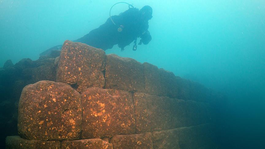
The preserved ruins of a castle dating back more than 3,000 years to the Iron Age under the civilisation of Urartu have been found by archaeologists from Van Yüzüncü Yıl University.
Tahsin Ceylan, head of the dive team, told the Turkish Daily Saba that “There was a report that there was something under the water but most archaeologists and museum officials told us that we’re not going to find it.” Instead, Ceylan and his team ended up uncovering a massive fortress spanning a kilometre over the lakebed.
The 3,000-year-old remains of an ancient fortification have been discovered at the bottom of Turkey’s largest lake. Divers exploring Lake Van discovered the incredibly well-preserved wall of a castle, thought to have been built by the Urartu civilization
“Since the water of Lake Van is alkaline, the castle has not been damaged and has kept its characteristics underwater,” Ceyland added to the Hurriyet Daily News, referencing Van’s distinction as the largest sodium lake in the world.
“We have detected the castle’s exact location and photographed it and have made progress in our research. We now believe we have discovered a new area for archaeologists and historians to study.”
As shown in the video below, the fortress appears remarkably well preserved, with mortared rocks giving way to perfectly cut, smooth stone walls.
Visible sections span some 9 to 14 feet, with much of the rest buried under sediment.
A boon to archaeology and tourism
Lake Van has been subjected to dramatic rises and falls in water levels throughout much of its history.
During the Ice Age, the lake was more than 200 feet above its present level, while some 9,500 years ago it was nearly 1,000 feet lower.
Because the lake has no outlet, it is rich in sediment, with some layers estimated to be more than 1,300 feet.
This makes it extremely interesting to climate scientists, who estimate these sediments may contain the preserved climate history of the last 800,000 years.
According to Ceyland, the discovery of the submerged castle is not only a boon to the archaeological community, but also for tourists interested in learning more about the region’s rich history.
“Many civilizations and people had settled around Lake Van,” he said. “They named the lake the ‘upper sea’ and believed it had many mysterious things. With this belief in mind, we are working to reveal the lake’s ‘secrets.”
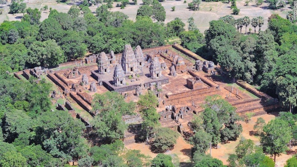
Sprawling Remains of Ancient Cities Discovered Beneath Cambodia’s Jungle
Every year, hundreds of thousands of tourists from around the world flock to visit the famed Angkor Wat temple in Cambodia. However, as exploration has uncovered evidence of mediaeval settlements under the jungle, it suggests that there will soon be new places to explore.
To shed new light on the society behind the world’s largest religious complex, researchers used laser technologies. Although the analysis has been ongoing for many years, the new findings uncover the sheer scale of the Khmer Empire’s urban sprawl and temple complexes to be significantly bigger than was previously thought.
Damian Evans and colleagues say they find evidence of extensive networks circling the colossal stone temple complex at Angkor Wat by using high-tech lasers to search the Cambodian jungle.
In 2012, the airborne Lidar system revealed a long-forgotten urban landscape in the jungle of Cambodia. The new research now reveals the sheer size of the ancient cities
Evans said their findings could further our understanding of Khmer culture and throw into question traditional assumptions about the 15th-century decline of the empire. Evans said a laser technology known as lidar was used to create precise maps of ancient networks that left only vague traces – invisible to the naked eye – in the landscape surrounding the temples.
‘You could be standing in the middle of the forest looking at what appear to be some random lumps and bumps,’ Evans said.
‘But they might actually be evidence of old excavated ponds or built-up roadways,’ he explained. ‘All of these things left traces in the surface of the landscape that wouldn’t make sense to you without a more detailed picture.’
To obtain such details, Evans said his colleagues spent 90 hours in a helicopter directing laser scans into the jungle surrounding Angkor Wat. He said that the resulting images are so intricate ‘you can see objects lying next to a tiny anthill.’
The research was published in the Journal of Archaeological Science. It was the result of a joint project including the French Institute of Asian Studies in Paris, the Cambodian national authority responsible for protecting Angkor Wat and the ministry of culture and fine arts.
New images from the survey show ancient cities near Angkor Wat were much bigger than previously thought. Above, a shaded relief map of the terrain around the central monuments of Sambor Prei Kuk
Angkor Wat, a UNESCO World Heritage site, is considered one of the ancient wonders of the world. It was constructed from the early to mid 1100s by King Suryavarman II at the height of the Khmer Empire’s political and military power and was among the largest pre-industrial cities in the world
For years, experts have assumed that the ancient Khmer civilization collapsed in the 15th century when invading Thai armies sacked Angkor Wat, forcing populations to relocate to southern Cambodia. But Evans said their laser maps showed no evidence of relocated, dense cities in the south and that it wasn’t clear there was any such mass migration.
Chanratana Chen, a Cambodian academic at the University of Sorbonne in Paris, said the new findings had changed his own perception of the Angkor Wat temple complex, which the Cambodian people commonly refer to as ‘the small city.’ Chen was not involved in the new research.
‘The new results (show) us that Cambodia was a much more advanced civilization than we thought, especially about the management plan of the city and irrigation system to improve agriculture in the area,’ Chen wrote in an email.
Among the most noteworthy discoveries, Evans and colleagues had found were proof of medieval sandstone quarries and traces of a royal road between various temple complexes, he said.
In 2012, the team discovered 1,200-year-old statues and temples. This research now builds upon those findings
Evans doubted tourists would soon be flocking to see the unremarkable ‘mounds in the ground’ that the lasers had decoded at Angkor Wat. But said he and colleagues have now pinpointed sites that might be fruitful for further excavation.
He said it was likely there could be similar such discoveries elsewhere in Southeast Asia, possibly in Burma and even the Americas, where archaeologists might unearth more secrets about the remains left behind by the 6th-century Mayan Empire.
Angkor Wat, a UNESCO World Heritage site, is considered one of the ancient wonders of the world. It was constructed from the early to mid-1100s by King Suryavarman II at the height of the Khmer Empire’s political and military power and was among the largest pre-industrial cities in the world.
The new findings build on scans that were made in 2012 that confirmed the existence of Mahendraparvata, an ancient temple city near Angkor Wat. However, until now, the sheer scale of the settlements was unknown.
Mr Chhay Rachna, of Cambodia’s APSARA National Authority, oversees excavations at the geometric features uncovered near Angkor Wat, guided by the lidar imagery
The new findings build on scans that were made in 2012 (pictured) that confirmed the existence of Mahendraparvata, an ancient temple city near Angkor Wat. However, until now, the sheer scale of the settlements has remained unknown
Mr Evans said: ‘What we had was basically a scatter of disconnected points on the map denoting temple sites. Now it’s like having a detailed street map of the entire city.’
Further maps will be published in the coming months. Long Kosal, a spokesman for the Apsara Authority, the government body that manages the Angkor complex, said the lidar had uncovered ‘a lot of information from the past.’
He said: ‘It shows the size and information about people living at those sites in the past,’ but added that further research was now needed to capitalise on the finds. While the Khmer Empire was initially Hindu it increasingly adopted Buddhism and both religions can be seen on display at the complex. Angkor is visited by hundreds of thousands of visitors a year and remains Cambodia’s top tourist attraction.
The information has helped archaeologists to map out the area and will help increase the accuracy of future digs. Pictured above, terrain in the mountains to the north of Angkor.
This digital terrain model of Preah Khan of Kompong Svay in Cambodia was taken using lidar
There are colonies of trees which have lived for millions of years. These trees are the eyewitness of emergence and decline of civilisations. Here we are covering the top 10 oldest trees of the whole world. Let’s have a look.
10. Chestnut Tree of One Hundred Horses
This tree, located on Mount Etna in Sicily, is the largest and oldest known chestnut tree in the world. Believed to be between 2,000 and 4,000 years old, this tree’s age is particularly impressive because Mount Etna is one of the most active volcanoes in the world.
The tree sits only 5 miles from Etna’s crater. The tree’s name originated from a legend in which a company of 100 knights were caught in a severe thunderstorm. According to the legend, all of them were able to take shelter under the massive tree.
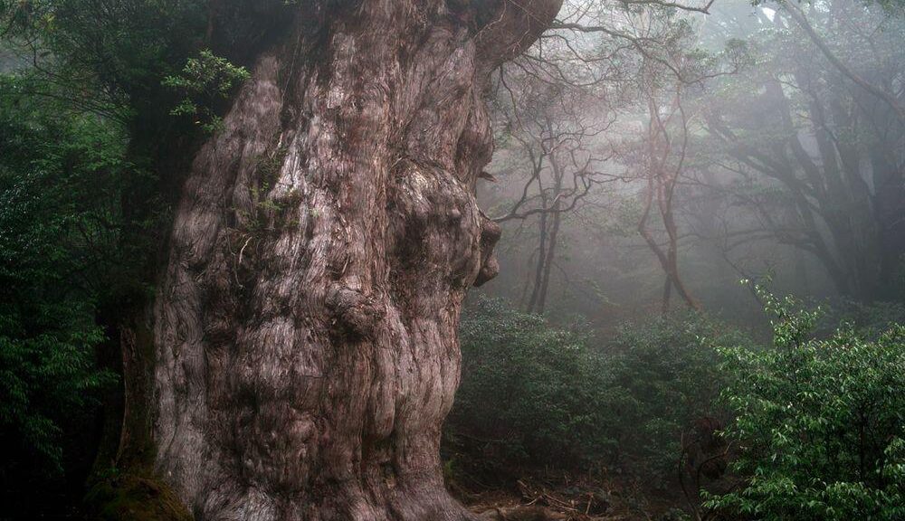
9. Jōmon Sugi
Jōmon Sugi, located in Yakushima, Japan, is the oldest and largest cryptomeria tree on the island and is one of many reasons why the island was named a UNESCO World Heritage Site.
The tree dates to at least 2,000 years old, but some experts believe it could be older than 5,000 years old. Under that theory, it’s possible that Jōmon Sugi is the oldest tree in the world — even older than Methuselah and its brethren. Regardless of the numbers, it’s a tree that deserves mention here.
8. Olive Tree of Vouves
This ancient olive tree is located on the Greek island of Crete and is one of seven olive trees in the Mediterranean believed to be at least 2,000 to 3,000 years old.
Although its exact age cannot be verified, the Olive Tree of Vouves might be the oldest among them, estimated at over 3,000 years old. It still produces olives, and they are highly prized. Olive trees are hardy and drought-, disease- and fire-resistant — part of the reason for their longevity and their widespread use in the region.
7. The Senator
Though the Senator suffered tragedy in 2012 after a fire caused much of the tree to collapse, this iconic tree bears mentioning here. Formerly located in Florida, the Senator was the largest bald cypress tree in the United States and was widely considered the oldest of its species known to exist. It was also likely the largest U.S. tree of any species east of the Mississippi River. Estimated to have been around 3,500 years old, the Senator was used as a landmark for the Seminole Indians and other native tribes.
The Senator’s size was particularly impressive because it endured many hurricanes, including one in 1925 which reduced its height by 40 feet. The tree got its name from Sen. M.O. Overstreet, who donated the tree and surrounding land in 1927.
6. Patriarca da Floresta
This tree, an example of the species Cariniana legalis named Patriarca da Floresta in Brazil, is estimated to be over 2,000 years old, making it the oldest non-conifer in Brazil.
The tree is believed to be sacred, but its species is widely threatened due to forest clearing in Brazil, Colombia and Venezuela.
5. Alerce
The Alerce is a common name for Fitzroya cupressoides, a towering tree species native to the Andes mountains. There’s almost no telling how old these trees can get since most of the larger specimens were heavily logged in the 19th and 20th centuries.
Many botanists believe they are the second-longest living trees on Earth aside from the bristlecone pine of North America. To date, the oldest known living specimen is 3,646 years old and is appropriately called Grand Abuelo.
4. Llangernyw Yew
This incredible yew resides in a small churchyard of St. Dygain’s Church in Llangernyw village, north Wales. About 4,000 years old, the Llangernyw Yew was planted sometime in the prehistoric Bronze Age — and it’s still growing! In 2002, in celebration of the golden jubilee of Queen Elizabeth II, the tree was designated as one of 50 Great British trees by the Tree Council.
3. Sarv-e Abarqu
Sarv-e Abarqu, also called the “Zoroastrian Sarv,” is a cypress tree in Yazd province, Iran. The tree is estimated to be at least 4,000 years old and, having lived through the dawn of human civilization not far away, it is considered an Iranian national monument. Many have noted that Sarv-e Abarqu is most likely the oldest living thing in Asia.
2. Methuselah
Until 2013, Methuselah, an ancient bristlecone pine was the oldest known non-clonal organism on Earth. While Methuselah still stands as of 2016 at the ripe old age of 4,848 in the White Mountains of California, in Inyo National Forest, another bristlecone pine in the area was discovered to be over 5,000 years old.
Methuselah and its unnamed senior pine’s exact locations are kept a close secret in order to protect them. You can still visit the grove where Methuselah hides, but you’ll have to guess at which tree it is. Could this one be it?
1. Old Tjikko
Old Tjikko is a 9,550-year-old Norway spruce, located on Fulufjället Mountain of Dalarna province in Sweden. Old Tjikko originally gained fame as the “world’s oldest tree.” Old Tjikko is, however, a clonal tree that has regenerated new trunks, branches and roots over millennia rather than an individual tree of great age. Old Tjikko is recognized as the oldest living Picea abies and the third oldest known clonal tree.
The age of the tree was determined by carbon dating of genetically matched plant material collected from under the tree, as dendrochronology would cause damage.
The trunk itself is estimated to be only a few hundred years old, but the plant has survived for much longer due to a process known as layering (when a branch comes in contact with the ground, it sprouts a new root), or vegetative cloning (when the trunk dies but the root system is still alive, it may sprout a new trunk).
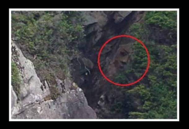
Man Discovers Mysterious ‘Face’ On Canada Cliffside After 2-Year Search
According to Parks Canada, a man from whom he has searched for the face for over two years recently rediscovered a mysterious large face on the cliff of one Island inside the Pacific Rim National Park Reserve.
Hank Gus from the First Nation of Tseshaht, an Aboriginal tribe in the area, learnt about the face of the rocks in Reeks Island, part of Broken Group Islands for the first time.
2 years ago, when someone told him a kayaking tourist spotted the face in 2008, said Parks Canada First Nations program manager Matthew Payne. He added that Gus was not able to find the face until just a few weeks ago.
The strange face was spotted on Reeks Island in British Columbia, Canada
“Gus and some Tseshaht beach keepers recently discovered it a few weeks ago, and they were very excited to share it with us and the archaeologist we work with,” Payne told ABC News today. “We went out to see it recently, and it’s remarkable. It really is a face staring back at you.”
The face, believed to be about 7 feet tall, is similar to a wooden carving on the door of the Tseshaht administration office, Payne said.
“The Tseshaht has lived in the area for thousands of years, so we’re working with the First Nations to find out if there are any oral histories the face could link back to,” he added.
Now the Tseshaht First Nation and Parks Canada are trying to figure out if the face is a man-made or natural marvel, he said.
“Mother Nature is capable of creating all sorts of amazing things, though the face is very striking,” Payne said. “But we still can’t definitively say if the face is man made or not.”
Though the Tseshaht and Parks Canada would like to examine the face up close, the face’s cliff is treacherous, he said.
“The island has a rocky shoreline with lots of hidden rocks, and it can be dangerous, depending on sea conditions,” he said. “You need to know what you’re doing to go and look at it.”
The Tseshaht First Nation did not immediately respond to ABC News’ requests for additional information.