All posts by Archaeology World Team

2,700-year-old Iron Age ‘loch village’ discovered in Scotland

2,700-year-old Iron Age ‘loch village’ discovered in Scotland

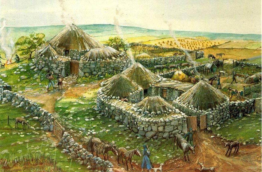
During a small-scale dig, archaeologists discovered what was initially believed to be a crannog – a loch shelter, a loch-dwelling often found on the banks of a loch or sited on an artificial island.

Archaeologists at the remains of an extensive iron age ‘loch village’ in Wigtownshire. 

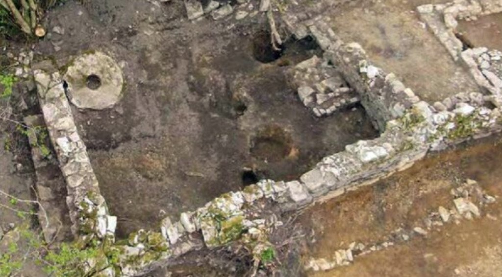
Instead, they discovered at least seven houses built in wetlands around the now in-filled Black Loch of Myrton, near Wigtownshire, in south-west Scotland. Called a “loch village,” this type of site is unique in Scotland and there are few other comparable sites elsewhere in the British Isles.

Similar lake villages have been found in Glastonbury and Meare, both in Somerset, but this is the first loch village to be uncovered in the north of the Border.

Archaeologists at the remains of an extensive iron age ‘loch village’ in Wigtownshire. 

Scotland’s Iron Age began some 2,700 years ago.

The Wigtownshire dig was a pilot excavation of what was thought to be a crannog, under threat by drainage operations.

However, during the excavation over the summer, AOC Archaeology Group – which worked on the dig in conjunction with local volunteers – discovered evidence of multiple structures.

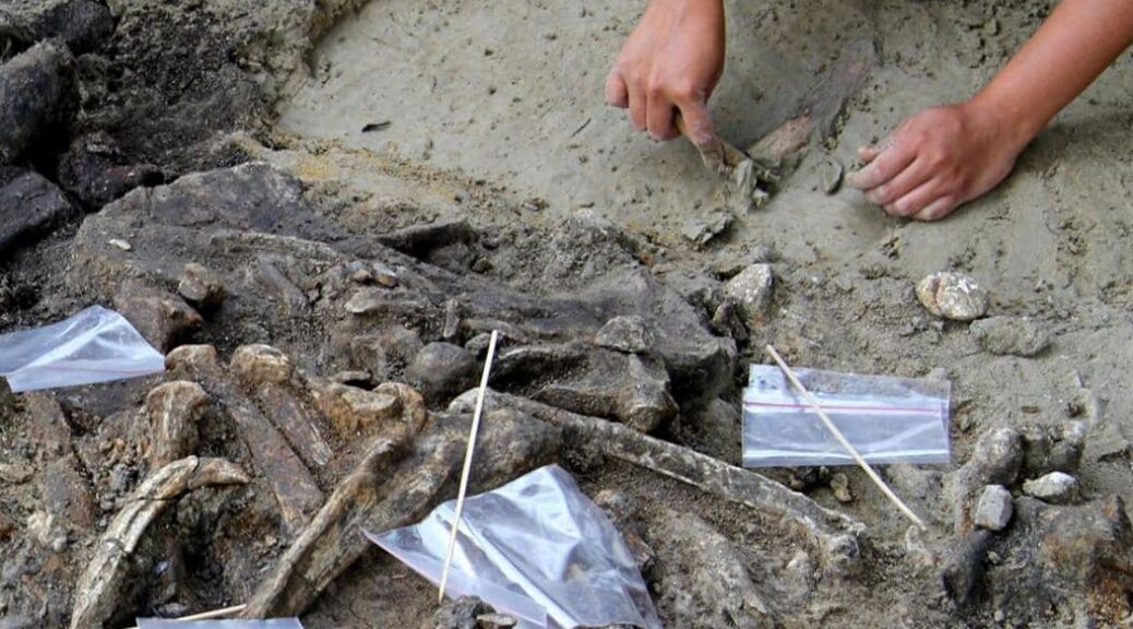
During the dig, which was part-financed with £15,000 from Historic Scotland, archaeologists realized that what appeared to be a small group of mounds was a stone hearth at the center of a roundhouse.

The timber structure of the house has been preserved, with beams radiating out from the hearth, forming the foundation, while the outer wall consisted of a double-circuit of stakes.

Rather than being a single crannog, as first thought, it appears to be a settlement of at least seven houses built around the small loch. Crannogs were probably the centres of prosperous Iron Age farms, where people lived in an easily defended location to protect themselves and their livestock from raiders.

Nancy Hollinrake, who runs an archaeology business with her husband in Glastonbury and who is also on the committee of the Glastonbury Antiquarian Society, said she was excited by the find.

She explained that although there were hundreds of crannogs in Scotland, this was different.

“It says a lot about the degree of protection they would have needed – having that many crannogs in one area,” she said.

“The industry would have been iron – and they would have been able to get the temperature of a furnace up to a point where they could smelt iron and make glass,” she added.

“There would have been high levels of craftsmanship and exchange of goods.

“They would also have carried out enamelling, bronzework, as well as spinning, weaving and dyeing large amounts of cloth. They decorated braids and played games with dice.”

Graeme Cavers, of AOC Archaeology, who is the co-director of the site, said that because the land was abandoned after the Iron Age, the buildings were well preserved.

“Waterlogged wood also offers the opportunity to date the structure very accurately using dendrochronology – or tree-ring counting – to give a date accurate to within a few years or even months, rather than the decades or centuries usually provided by radiocarbon dating,” he added.

Archaeologists in Egypt reveals ‘elite’ mummies, jars filled with organs, and mystery snake cult

Archaeologists in Egypt reveals ‘elite’ mummies, jars filled with organs, and mystery snake cult

The ancient Egyptians, known for their elaborate mummies, took a lot of care in preparing for the afterlife. Now, for the first time, archaeologists have discovered that they had a bustling funeral industry, too. As it turns out, priest-embalmers were also savvy business people whose tactics presaged the modern funeral industry.

A burial workshop unearthed in 2018 in Saqqara, a necropolis (or city of the dead) 20 miles south of Cairo, offered Egyptologists the first major opportunity to document a site where mummies were made.

Archeologists behind early excavations likely overlooked such sites in their eagerness to uncover richly decorated royal tombs.

But as it turns out, the Egyptian funeral parlor wasn’t just preparing the pharaohs for the afterlife. They offered a whole range of services, from ornate golden funerary masks to cheaper plaster ones embellished with gold foil. The canopic jars, which stored the organs of the dead, could be made from alabaster or cheaper painted clay.

“The evidence we uncovered shows the embalmers had very good business sense,” says Ramadan Hussein, an Egyptologist at the University of Tübingen in Germany, told National Geographic. “They were very smart about providing alternatives.”

In a tomb deep below the desert, Egyptologist Ramadan Hussein (left) and mummy specialist Salima Ikram (right) examine the coffin of a woman who was laid to rest inside a limestone sarcophagus weighing more than seven tons.

The ancient funeral parlor was located beneath a burial shaft that had last been investigated in the late 1800s—archaeologists had to remove 42 tons of debris to access the chamber, found just three feet below where the earlier excavations had ceased.

Hussein soon realized that what they had found wasn’t a tomb, but the site where bodies were prepared for burial. There was an air shaft that would have provided crucial ventilation, bowls containing traces of the oils and resins used in mummification, and a table-like slab perfect for laying out bodies.

The excavation of the funeral parlor also uncovered six nearby tombs, home to some 50 mummies that illustrate how the business offered its services to different clientele.

The wealthy, buried the deepest—the closest to the underworld—bought such expensive trappings as a limestone sarcophagus and a silver face mask with gold gilding, only the third of its kind ever discovered. The working class on the tomb’s upper tiers, on the other hand, settled for simple wooden coffins.

The rare silver face mask gilded with gold. Photo courtesy of the University of Tübingen, Ramadan Hussein.

The afterlife was hugely important to the ancient Egyptians, and the ritualized mummification process that ensured one’s safe journey to the underworld took a full 70 days.

Embalmers carefully packed the internal organs into four canopic jars, then dried the body out with salt, anointed it with oil, and wrapped it in linen. The finished mummy would be laid to rest in a fully provisioned tomb, according to the family’s means.

Loved ones would pay embalmers regular fees for the upkeep of the dead, according to papyrus documents found in Saqqara over 100 years ago. The discovery of an actual Egyptian funeral parlor offers the first physical evidence of this practice.

“Mummification was a business transaction between an individual and an embalmer in which the embalmer was a specialist, a priest, and a businessman,” Hussein told.

One of two extra mystery canopic jars containing an unidentified organ, buried with the coffin of a woman named Didibastet. Photo courtesy of the Egypt Ministry of Tourism and Antiquities.

Among the important discoveries at the site was the coffin of a woman named Didibastet, who was buried with six canopic jars, two more than tradition dictates, reports Al-Ahram Weekly.

All of the jars contain human tissue, a CT scan revealed, suggesting that this was a special form of mummification that preserved additional organs beyond the lungs, stomach, intestines, and liver. The team’s radiologist is now studying the jars to identify the extra organs.

Archaeologists Find Unique 1,400-Year-Old Christian Artifact

Archaeologists Find Unique 1,400-Year-Old Christian Artifact

Around 1,400 years ago, citizens lived near Vindolanda, a northern England Roman fort, inscribed a lead chalice with images of crosses, angels, and other Christian symbols. Now, reports Dalya Alberge for the Guardian, archaeologists say that this vessel—unearthed during the excavation of a ruined sixth-century church—represents the oldest known example of Christian graffiti ever found in Britain.

A fragment of the 1,400-year-old Christian chalice found at Vindolanda in Northumberland, northern England.

The chalice was once the size of a cereal bowl, recovered in 14 pieces. Inscriptions adorn every inch of its surface, covering both its interior and exterior. Per a statement, symbols seen on the cup include a chi-rho (or monogram said to represent Jesus Christ), a happy bishop, ships, a congregation, a fish, and a whale. Latin, Greek, and potentially Ogam letters appear alongside the drawings.

Vindolanda served as a key outpost used during construction of Hadrian’s Wall, a 73-mile stone barrier constructed around 122 A.D. to mark the edge of the Roman Empire. Prior discoveries at the fort, including a board game and a scrap of leather cut into the shape of a mouse, have helped reveal aspects of daily life under Roman rule.

Rome controlled Britain for 330 years, only withdrawing from the region in 410 A.D. By the time the chalice arrived on the scene, the Romans had long since abandoned Vindolanda.

Andrew Birley, the archaeologist in charge of excavations at Vindolanda, tells the Guardian, “The discovery helps us appreciate how the site and its community survived beyond the fall of Rome and yet remained connected to a spiritual successor in the form of Christianity.”

Speaking with BBC News, Birley says that finding “a chalice smothered in Christian symbols” offers an opportunity for heightened understanding of Christianity’s spread across the region.

He adds, “Many potential church structures have been located from this period, but without the Christian artifacts to back that up, they could not be proven beyond doubt.”

Fragments of the 1,400-year-old Christian chalice found at Vindolanda in Northumberland, northern England.

Thanks to the inscribed vessel, researchers may be able to recontextualize potential churches from the same period that lack clear evidence of Christendom.

As Birley tells Chiara Giordano of the Independent, the inscriptions may have conveyed Christian stories at a time when Bibles were not yet widely available.

Studying the chalice, he says, could help reveal “what was important to congregations almost 1,500 years ago and just after the fall of Roman Britain.”

Remnants of the church suggest it was large enough to house up to 60 worshippers, according to the Independent. At some point, the house of worship collapsed, burying the chalice and inadvertently protecting it from both modern agriculture and thieves.

David Petts, an archaeologist at Durham University who is studying the artifact, tells the Guardian that the find “is genuinely exciting.”

He explains, “When we think of graffiti, we tend to think it’s unauthorized vandalism. But we know from many medieval churches, that people would put marks and symbols on buildings. What is unique about this is finding them on a vessel.”

The chalice’s fragments will now go on display in Vindolanda’s museum as the centerpiece of a new exhibition centered on the site’s history following the Romans’ departure.

2,500-Year-Old Lost City Atop a Greek Mountain Peak discovered by archaeologists

2,500-Year-Old Lost City Atop a Greek Mountain Peak discovered by archaeologists

A team of archaeologists working in Greece has made a sensational discovery that can lead to a new understanding of the ancient world.

The city’s acropolis is barely visible during a cloudy day on the Thessalian plains.

An international group of researchers from the University of Gothenburg, Sweden announced last month that they had found the ruins of a 2,500-year-old metropolis buried atop the Strongilovoúni hill on the great Thessalian plains.

The unknown city, located near the village of Vlochos in central Greece, is believed to have been a metropolis according to the extent of the ruins found there, rather than an obscure settlement on a mountain.

Fortress walls, towers and city gates are clearly visible from the air.

“Most striking of the visible remains at the site are the well-preserved fortifications, at points still 8 feet high, but the lower slopes below the hill show clear indications of being the location of an extensive urban settlement, now covered by silt and sediment from the nearby river Enipeas,” says Robin Rönnlund, PhD student in Classical Archaeology and Ancient History at the University of Gothenburg and leader of the fieldwork.

“A colleague and I came across the site in connection with another project last year, and we realised the great potential right away.

The fact that nobody has explored the hill before is a mystery,” he added.

The researchers believe that the presence of a major city in an area previously considered a backwater of the ancient world can deliver new findings on a tumultuous period in Greek history.

The sensational discovery comes just weeks after Egyptian archaeologist discovered a 7,000-year-old lost city along the Nile, also thought to have been an important metropolis.

While almost none of this is visible from the ground below, the 99-acre area contains a tower, the main square, walls and gates, and a street grid indicative of the city’s significance and size.

Thanks to pottery and coins found at the site, the researchers can estimate the city’s date. “Our oldest finds are from around 500 BC, but the city seems to have flourished mainly from the fourth to the third century BC before it was abandoned for some reason, maybe in connection with the Roman conquest of the area,” says Rönnlund.

Fragment of red-figure pottery from the late 6th century BC, probably by Attic painter Paseas.

In order to avoid disturbing the site, the archaeologists are using a ground-penetrating radar rather than excavating. The method has proven highly effective, as the structures discovered so far have all been recognized by the radar rather than dug up.

A 1,600-year-old cargo of a Roman merchant ship has been discovered in Caesarea

A 1,600-year-old cargo of a Roman merchant ship has been discovered in Caesarea

In recent times, divers have discovered some rarity of archaeological artifacts on the bottom of the sea off the coast of Israel in Caesarea.

The objects that seem to have been part of a Roman merchant ship cargo that sank some 1,600 years ago include coins, bronze statues, equipment used in running the ship, such as anchors, and numerous decorative items.

The treasure trove was discovered by accident by two amateur divers from Ra’anana, Ran Feinstein, and Ofer Ra’anan, who were swimming in the ancient harbor.

The rare bronze artifacts that were discovered in Caesarea.

Upon emerging from the sea, they immediately contacted the Israel Antiquities Authority. Since then, the IAA’s marine archaeology unit has been conducting an underwater excavation of the site, in cooperation with the Rothschild Caesarea Foundation.

Among other finds, the cargo of the ship, which apparently sank in the latter years of the Roman Empire (27 B.C.E. – 476 C.E.), included a bronze lamp depicting the image of the Roman sun god Sol; a figurine of the moon goddess Luna; a lamp resembling the head of an African slave; parts of three life-size bronze statues; a bronze faucet in the form of a wild boar with a swan on its head; and other objects in the shape of animals. Also unearthed were shards of large containers used for carrying drinking water for the ship’s crew.

An Ancient Roman figurine discovered from the shipwreck.

One of the biggest surprises was the discovery of two metallic lumps each composed of thousands of coins, in the shape of the ceramic vessel in which they were transported before they oxidized and became stuck together.

The coins bear the images of the Constantine, who ruled the Western Roman Empire (312 – 324 C.E.) and was later known as Constantine the Great, ruler of the entire Roman Empire (324 – 337 C.E.), and of Licinius, a rival of Constantine’s who ruled the eastern part of the empire and was slain in battle in the year 324 C.E.  

According to Jacob Sharvit, director of the IAA’s marine archaeology unit, and his deputy Dror Planer, “These are extremely exciting finds, which apart from their extraordinary beauty, are of historical significance.

The location and distribution of the ancient artifacts on the seabed indicate that a large merchant ship was carrying a cargo of metal slated to be recycled, which apparently encountered a storm at the entrance to the harbor and drifted until it smashed into the seawall and the rocks.”

A preliminary study of the iron anchors unearthed at the site suggests that there was an attempt to stop the drifting vessel before it reached shore by casting them into the sea; however, the anchors broke, which constitutes “evidence of the power of the waves and the wind in which the ship was caught up,” say the researchers.

The discovery comes just a year after a trove of over 2,000 gold coins, dating to the Fatimid era about 1,000 years ago, was found nearby by divers and IAA staff. The coins are currently on public display in the Caesarea marina.

“A marine assemblage such as this has not been found in Israel in the past 30 years,” Sharvit and Planer explain. “Statues made of metallic materials are rare archaeological finds because they were always melted down and recycled in antiquity.

When we find bronze artifacts it usually occurs at sea. Because these statues were wrecked together with the ship, they sank in the water and were thus ‘saved’ from the recycling process.”

The archaeologists said the underwater treasures were discovered because of the diminishing amount of sand in the Caesarea harbor as a result of construction along the coastline south of the site, and due to the increased mining of sand – as well as the growing number of amateur divers in the area.

The IAA praised the two amateur divers for their good citizenship in reporting their find and announced that they will accordingly be awarded certificates.

Lumps of coins that were discovered at sea, weighing a total of around 20 kilograms.

Archaeologists Excavate Roman Villa at Pompeii

Archaeologists Excavate Roman Villa at Pompeii

The suburb of the ancient city of Pompeii was populated by numerous settlement complexes, scattered over a territory which responded to productive (wine and oil-producing farms) as well as residential or seasonal needs when the owner needed to stay temporarily.

The safeguarding activity carried out by the Archaeological Superintendency of Pompeii and now by the Archaeological Park of Pompeii has allowed us to outline a rather complex and articulated context, with the identification of various ‘villas’, located in the relevant territory.

The current excavation operation, in Civita Giuliana, around 700m northwest of the walls of Ancient Pompeii, as well as confirming this data, has brought to light the servile-productive sector of a large villa, which had already been partially investigated at the beginning of the 20th century, and the area (to the south and southwest of the structure) dedicated to agricultural use.

The new excavations have revealed the presence of a rectangular structure with 5 quadrangular rooms, constructed with opus reticulatum walls (a form of Roman brickwork consisting of diamond-shaped bricks of tuff, referred to as cubilia, placed around a core of opus caementicium).

Two rooms have so far been extensively studied. The first room is located on the western side of the structure and is decorated with a thin layer of white plaster with traces of red stripes.

The room contains a quadrangular niche called a lalarium (a shrine to the guardian spirits of the Roman household) that is bordered by a plaster frame with a quadrangular marble base. Several items, including two items of furniture, were identified as voids in the pyroclastic flow deposits that have been replicated with plaster casts.

The second room contains the remains of animals, one complete with a connected skeletal structure and a second small animal located in front of a wooden trough.

The excavation has posed new questions on the peculiarities of the complex, and has opened, or rather reopened, the debate regarding its planimetric development.

The Historic Excavations

Between 1907 and 1908, the Marquis Giovanni Imperiali carried out excavations in the area immediately to the north of the current area, on the basis of an excavation permit granted by the then Ministry of Education to the private individual, according to the norms of regulations in force at the time, and whose reports were published in 1994 with a monograph by the Superintendency.

The historic excavation unearthed 15 rooms relating to two sectors of the villa, one residential and the other productive.

The residential sector was arranged around a rectangular plan peristyle, bordered on the north and east sides by a portico supported by masonry columns, whilst the western side – presumably taking advantage of a natural rise in height, was bordered by a long cryptoporticus covered by a terrace onto which the peristyle opened, with a view over the land in front.

On the eastern side of the peristyle, five rooms were discovered (the only ones whose structure it has been possible to locate, thanks to photographic documentation of the excavation), decorated with paintings of the Third and Fourth Style, and which yielded a varied typology of objects related to daily life, personal adornment, and domestic worship.

Regarding the productive sector, which was probably located on the northeastern side of the building, we lack the information necessary to be able to locate it with certainty, but undoubtedly it consisted of a torcularium, a wine cellar, and other rooms for storing foodstuffs produced in the agricultural land which surrounded the building; the position of a lararium in the southeastern corner of the courtyard is also uncertain.

Over the course of the following years, other random finds have revealed further remains of the structures. In 1955, just before one of the tests carried out during the current investigation, the Archaeological Superintendency brought to light the dividing walls; of particular interest is the presence of two walls parallel and perpendicular to the road track, joined by a connecting wall in opus craticium.

700,000-Year-Old Stone Tools Point to Mysterious Human Relative

700,000-Year-Old Stone Tools Point to Mysterious Human Relative

A recent finding of stone instruments and other evidence has shown that in Southeast Asia hominins, our pre-human relatives – were in South East Asia hundreds of thousands of years earlier than we thought.

The 57 stone tools and an almost complete rhinocéros skeleton which shows signs of being butchered were found in the Philippines and date back 709,000 years.

Previously, the earliest evidence for hominin habitation in the area was found in Callao Cave, a river-floodplain on the northern island of Luzon. It’s only 67,000 years old.

Researchers found a 700,000-year-old site on the Philippine island of Luzon where unknown hominins butchered a rhinoceros. To avoid damaging the bones, the team dug them up with only bamboo sticks.

The tools found consist of 49 sharp-edge stone flakes, six cores – the stones from which the flakes are hammered – and two possible hammer stones. In addition, the site yielded a collection of skeletons: a stegodon, brown deer, freshwater turtle, and monitor lizard.

The rhinoceros skeleton was very interesting. Several of the bones had cut marks consistent with butchering, and the humerus bones seemed to have been hit with a hammerstone, possibly to access the rich marrow inside.

The tools weren’t made by humans – our oldest evidence of Homo sapiens is from about 300,000 years ago – but by a close ancestor. And their presence means we need to reconsider how humans and hominins spread through South East Asia.

Archaeologist Gerrit van den Bergh from the University of Wollongong in Australia says that hominins most likely spread through the region in several waves throughout the millennia.

He also believes that they probably travelled from north to south from China and Taiwan, rather than west to East from Borneo or Palawan through Indonesia, using the ocean currents and settling as they went.

Eventually, this migration could have landed on the Indonesian island of Flores to give rise to Homo floresiensis, also known as the “hobbit” for its small stature.

Evidence of hominins dating back 700,000 years has been found on the Indonesian island of Java. In addition, Homo floresiensis ancestors have been found on Flores from around the same time. Both of these finds are consistent with the new migration hypothesis.

Previously, it had been thought that hominins didn’t have boats, and therefore couldn’t have travelled by water to reach Luzon and the other islands of Wallacea, the group of islands separated from mainland Australia and Asia by deep oceans.

But the north-to-south migration hypothesis is supported by another fossil record: that of animals.

“If you look at the fossil and recent faunas you see that there is an impoverishment as you go from north to south. On Luzon, you find fossils of stegodons, elephants, giant rats, rhino, deer, large reptiles, and a type of water buffalo.

“On Sulawesi, the fossil fauna is already impoverished; there’s no evidence of rhinos or deer ever entering there. Then on Flores, you only had stegodons, Komodo dragons, humans, and giant rats, that’s all,” van den Bergh said.

“If animals did reach these islands by chance, by entering the sea and following the currents south, then you would expect the further south you go the fewer species you would find – and that’s what we see.”

If the animals didn’t have boats, the humans needn’t have either. However, they could have had rafts, used for fishing, or been caught up in debris and carried out to sea by tsunamis, which are relatively common in the area.

Who these hominins were is unknown, and will probably remain so without their bones to study. They could have been the ancestors of the owner of that foot bone hundreds of thousands of years later; they could have been Luzon’s version of Homo floresiensis; or they could have been a different group, perhaps even the mysterious Denisovans. But the discovery has archaeologists excited to keep digging to see what else they can find.

“There’s a lot of focus again in the islands of South East Asia because they are places where you find natural experiments in hominin evolution. That’s what makes Flores unique, and now Luzon is another place we can start looking for fossil evidence,” van den Bergh said.

“On Flores, we’re pretty certain they arrived about 1 million years ago based on stone tool evidence, but we don’t know when hominins first arrived on Luzon. Now we can go looking in older strata and see if we can find more artifacts, or even better, fossil evidence.”

5,700-year-old Neolithic house discovered by archaeologists in Cork

5,700-year-old Neolithic house discovered by archaeologists in Cork

Archaeologists in North Cork have uncovered the foundations of a 5,700-year-old Neolithic house in addition to evidence of Iron Age smelting and Bronze Age burial sites. 

5,700-year-old Neolithic house discovered by archaeologists in Cork
The incredible discoveries were made following eight excavations in sites across north Cork

The archaeologists excavated a total of eight sites as part of two road realignment projects on the N73 road which links Mallow and Mitchelstown, near the villages of Shanballymore and Kildorrery, and a house dating back to 3700BC was found at one of the sites.

It is believed that the house belonged to some of the very first people to live in the area and found alongside were quantities of grain, pottery, and stone tools dating back to the same period.

At a different site in the townland of Waterdyke, archaeologists found evidence of charcoal pits required in the smelting process to produce iron. The pits date back to between 266AD and 1244AD while further evidence of smelting was also found at Annakiska South. 

There was also evidence of a 17th-century enclosure at Annakiska South as well as clay pipes and glass in addition to evidence of a 17th-century smithy situated on the original road that would have made horseshoes for travelers passing between Mallow and Mitchelstown. 

Clay pipes believed to be from the 17th century were among the fragments unearthed by archaeologists in Cork

The Irish Examiner reports that farming knowledge only arrived in Ireland around 200 years before this house was built, meaning that the settlement is one of the oldest farming settlements on the island of Ireland. 

Archaeologists also discovered evidence of ritual sites dating back to roughly the same period at the settlement. 

They found evidence of stone tools and pottery deliberately buried in holes in the Middle Neolithic era (3500BC to 2900BC) in a form of ritual that may have been associated with human burials.

Middle-neolithic pottery found in a sinkhole in Clenor South possibly left as an offering from the people who believed the natural phenomena were portals to the underworld

The tools and pottery may have been buried as an offering of gifts for the gods of the underworld. 

There was also evidence of a barrow cemetery dating back to the Bronze Age nestled by the banks of a meandering stream and overlooked by a nearby settlement. 

Cork County Council and Transport Infrastructure Ireland (TII), who carried out the excavations and the roadworks, published an “online story map” documenting the archaeologists’ results. 

The online map, created by TII project archaeologist Ken Hanley and Cork County Council resident archaeologist Ed Lynne, also documents previously discovered sites along the route and can be viewed here.