Posh grave of Iron Age ‘warrior’ buried 2,000 years ago in Roman Britain uncovered
UCL archaeologists have uncovered a richly furnished grave belonging to an Iron Age ‘ warrior ‘ found 2,000 years ago in West Sussex.
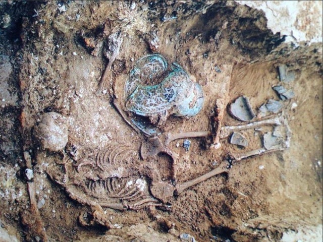
Iron Age warrior grave excavated in West Sussex
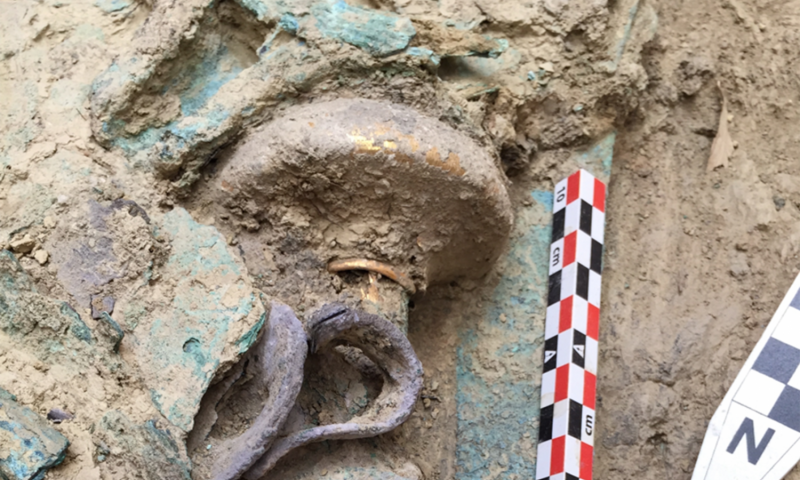
In the grave were placed iron weapons, including a sword in a highly decorated scabbard and a spear. The burial was discovered during an excavation commissioned by Linden Homes, who are developing a site on the outskirts of Walberton, near Chichester, to create 175 new homes.
The team that made the discovery were from Archaeology South-East (ASE), the commercial branch of UCL’s Institute of Archaeology.
ASE archaeologist Jim Stevenson, who is managing the post-excavation investigations into the burial, said: “There has been much discussion generally as to who the people buried in the ‘warrior’ tradition may have been in life.
Were they really warriors, or just buried with the trappings of one?
Sword midway through conservation and its X-rays
“Although the soil conditions destroyed the skeleton, the items discovered within the grave suggest that the occupant had been an important individual.”
The grave is dated to the late Iron Age/ early Roman period (1st century BC – AD 50). It is incredibly rare, as only a handful are known to exist in the South of England.
X-rays and initial conservation of the sword and scabbard reveal beautiful copper-alloy decoration at the scabbard mouth, which would have been highly visible when the sword was worn in life.
Dotted lines on the X-ray may be the remains of a studded garment worn by the occupant when buried. This is particularly exciting for archaeologists as evidence of clothing rarely survives.
Ceramic jar found in the grave
The grave also held the remains of a wooden container, preserved as a dark stain, likely used to lower the individual into the grave.
Four ceramic vessels were placed outside of this container, but still within the grave. The vessels are jars made from local clays and would usually have been used for food preparation, cooking and storage.
It is likely that they were placed in the grave as containers for funerary offerings, perhaps intended to provide sustenance for the deceased in the afterlife.
Archaeologists are continuing to investigate this new discovery. By looking at other burials with weapons from the same time, they hope to find out more about the identity and social status of this individual, and the local area and landscape around that time.
Site of 18th-Century Steam Engine Uncovered in Slovakia
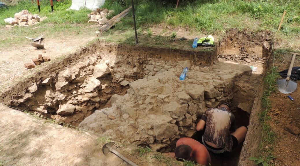
In recent day’s Nová Baňa, approximately 40 volunteers have worked under the expert supervision of archeologists to unleash a special Potter atmospheric steam engine, the first one of its kind on the continent of Europe.
In the Althandel shaft, the atmospheric steam engine was built and was used in the 18th century. Enthusiasts from the mining group Novobanský had decided a while ago to reveal this treasure to the public, hidden in the garden of one house.
Matej Styk, an expert assistant from the Department of Archaeology of the Constantine the Philosopher University in Nitra, said that two-week research followed last year’s findings of the archaeologists. Its aim was to research the discovered construction and the discovered features, proving mining activity in the 18th century.
“In two weeks, we succeeded in uncovering the entire measurement of the Potter engine room, about eight and 14 meters,” he said, as quoted by the TASR newswire. He added that the masonry is compact, undamaged, located about 30 to 40 centimeters under the ground surface.
Bigger than anticipated
Thanks to research, they can prove that activities were ongoing not only in the 18th but also in the 19th century. In the interior of the engine room, the bases of another construction were found, about which there was no knowledge until now.
“There were many tiles from a stove inside,” Styk noted for TASR. “We think that the building was wooden. It has a stone foundation wall and inside another production activity was ongoing.”
Styk noted that the measures of the engine room itself were surprising. The building was bigger than they anticipated.
They succeeded in finding several interesting objects during the research, a mining button from probably the 19th century, a pipe or various iron nails, and components.
Mining failed
The steam engine served to drainage of water from mine. The head of the Slovak mining archive in Banská Štiavnica, Peter Konečný, said that it was built by Isaac Potter in the Althandel shaft in the years 1721-1722.
“Isaac Potter operated this machine alongside his colleagues within the mining industry, which received the right to mine local ores,” Konečný noted, as quoted by TASR.
However, mining was not successful, over in a few years and the machine put out of the operation, Konečný said. Potter remained for several years, but the state, which paid the construction, offered the opportunity to shift it to another private miner, to Hodruša.
“There we lost its traces because the supposed shift to Banská Štiavnica did not happen,” said Konečný for TASR, adding that this assumption is not proven.
The remains of the unique machine should be accessible to the public in the future. The association would like to build an open-air folk museum at the site. They succeeded in persuading the municipality in purchasing the house with the garden where the engine room was discovered.
Museum and replica planned
The head of the association, Zoltán Vén, said that the original owners did not have a clue as to the treasure in the ground. The association was behind the finding, which discovered it inaccessible documents.
Vén noted that they have big plans with the compound. They would like to build a replica of the machine and they have some ideas on how to use the house as well. It should be the headquarters of the mining association and a museum exhibition.
Vén said that last year, British Ambassador Andrew Garth, who is leaving Bratislava at the end of July, also visited the place.
“We would like to have contact with him to be able to go to the UK, as they have one museum piece working. We would like to see it,” Vén summed up, as quoted by TASR.
Bronze Age time capsule: 3,000-year-old vitrified food found in jars in England
The life of the prosperous people of Bronze Age Britain could be “extraordinary proof” that remains under the ground of a 1,100-square meter site destroyed by the fire 3,000 years ago. They suggest that archeologists are about to dig in a brick pit near Peterborough.
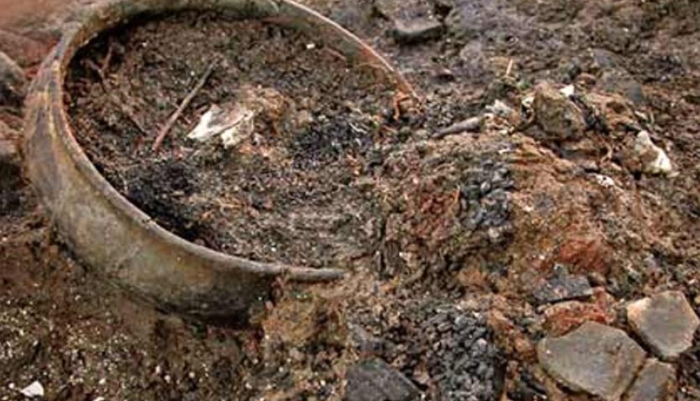
Archaeologists found food from between 800-1000 BC in a set of pots, textiles and other material at a Cambridgeshire settlement destroyed by fire during the Bronze Age
Must Farm – part of the Flag Fen Basin, and the site where nine pristine log boats were famously unearthed in 2011 – was protected by a ring of wooden posts before a dramatic fire at the end of the Bronze Age caused the dwelling to collapse into the river.
Its submergence preserved its contents, creating what experts are describing as a “time capsule” of “exceptional” decorated tiles made from lime tree bark.
An Early Iron Age logboat found in the palaeochannel
Rare small pots, jars complete with 1,200-year-old meals, and “sophisticated” exotic glass beads are expected to provide a complete picture of prehistoric life during the nine-month excavation, which is part of a four-year, £1.1 million project at the site.
“We think those living in the settlement were forced to leave everything behind when it caught on fire,” says Kasia Gdaniec, Cambridgeshire County Council’s Senior Archaeologist.
“An extraordinarily rich range of goods and objects are present in the river deposits, some of which were found during an evaluation in 2006.
A Late Iron Age baldric ring with La Tène style decoration, probably part of a shoulder belt for carrying a sword, found in the peat which formed in the Must Farm palaeochannel when then the watercourse became entirely choked by sediment at the end of the first millennium BC
“Among the items was a charred pot with vitrified food inside it and a partially charred spoon, suggesting that the site had been abandoned quickly.
“We anticipate that more of the timber structure, a range of organic remains and fishing equipment and the whole gamut of personal, work, and settlement paraphernalia will be found.
“But we are hoping not to find remains of people that may have suffered the impact of the fire, though this possibility cannot be ruled out.
“It’s an exciting excavation. The finds are well preserved due to the waterlogged sediments within this former river channel. The footprints of the settlement’s former residents still stand, although more discoveries are not expected to emerge until late summer.
The mass of preserved timbers was originally discovered during an excavation in 2006
“Usually at a Later Bronze Age period site you get pits, post-holes and maybe one or two really exciting metal finds,” says David Gibson, the Archaeological Manager at the Cambridge Archaeological Unit.
“Convincing people that such places were once thriving settlements takes some imagination. But this time so much more has been preserved.
“It’s a fantastic chance to find out how people in the Late Bronze Age lived their daily lives, including how they dressed and what meals they ate.”
The location of the site, at the edge of the quarry, meant attempts to preserve it in situ after it was discovered in 2006 proved unviable as a long-term historic record.
“The combination of sudden abandonment followed by exceptional preservation means that there is a real possibility of further exciting discoveries,” says Duncan Wilson, of Historic England.
“This could represent a moment of time from the Late Bronze Age comparable to the connection with the past made by the objects found with the Mary Rose.
“This site is internationally important and gives a fascinating insight into the lives of our ancestors.”
A rapier and sword were found at the clay quarry, now run by a building company, in 1969. The new discoveries will be displayed at the Peterborough Museum and other local venues.
Millennia-Old Rock Art in Israel Offers Window Into Lost Culture
The chance discovery of lines carved into the boulders of an ancient tomb in what is now the Israeli-occupied Golan Heights could offer new insight into an enigmatic culture that thrived thousands of years ago.
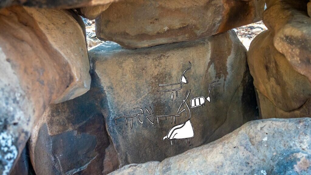
Archaeologists discovered rock art engraved inside this 4,000-year-old stone monument in northern Israel. Illustrations highlight the herd of horned animal figures etched into the boulder
In a small clearing in the Yehudiya nature reserve, between yellow weeds and shaded by eucalyptus trees, huge dark basalt boulders and slabs form a small roofed chamber that opens to the east. The megalithic structure is one of the thousands of so-called dolmens scattered around northern Israel and the wider region, burial tombs erected some 4,000-4,500 years ago in the Intermediate Bronze Era.
Today, on the plateau captured in 1967 from Syria, with Israeli soldiers securing the frontier just 23 kilometers (14 miles) away, scientists seek to shed light on the region’s distant past. The identity and beliefs of those who built the monuments remain largely unknown. But a recent serendipitous finding of rock art might change that.
The rock art findings — published in a recent article by Sharon and Berger in the journal Asian Archaeology — display the animal drawings in this ancient culture for the first time.
About two years ago, “when one of the rangers here in the park walked her daily walk, she looked inside and saw something carved in the walls,” recalled Uri Berger, an archaeologist with the Israel Antiquities Authority.
The ranger contacted the IAA, and “when we looked inside we saw this is not just lines carved or some stains on the wall, this is rock art,” Berger said. The lines form the shapes of six horned animals of varying sizes, three facing east and three facing west, with two of them — likely a male and female — directly facing each other.
Another horned animal is carved into the interior of one panel, facing the other six. The zoomorphic depictions, hidden in plain sight since the study of the dolmens began 200 years ago, were the first to be discovered in the region and a major development for Berger and his research partner, Gonen Sharon.
Sharon, an archaeology professor at the Tel-Hai college in northern Israel, is responsible for a previous landmark discovery. Just north of the nature reserve, outside the northern Galilee Kibbutz Shamir, Sharon was hiking with his children in 2012 on a field with some 400 dolmens spread across it.
The capstone of a dolmen at Kiryat Shemona features three straight lines carved in an approximation of a human face.
Crawling into the shade of the largest monument, Sharon sat down, looked up at the huge slab roof of the dome, and said he noticed “weird shapes” that didn’t look like natural formations.
“It looked like someone made them,” he recalled.
The markings were found to be a series of man-made carvings resembling tridents.
“It turned out this was the first artwork done in the context of dolmens in the Middle East,” Sharon said. The Shamir carvings, unnoticed by generations of researchers, reinvigorated archaeological study in the area. One of the sites revisited was inside an industrial zone near Kiryat Shmona, a town northwest of Shamir, where three small megalithic structures that survived the zone’s development a few decades ago are surrounded by circles of stones.
On the relatively rounded capstone of the largest dolmen there, two sets of short parallel lines are carved into each side of the rock, with a longer line carved below creating the image of closed eyes and a grimacing mouth facing the sky.
“The grooves don’t seem to be functional,” said Sharon. “To us, they look like a face.”
The stone monuments have “altered the landscape” of northern Israel, said Berger. But their prominence has also made them targets for antiquities theft, which largely stripped remains that could provide clues to their creators.
Small pieces of ceramics, metal spearheads and daggers, bits of jewellery and beads, and some bones are found at the sites from time to time, Sharon said. “But it’s very rare to find” anything, and such finds are very scattered.
“We know very little of the actual culture of the people who built them.”
With the discovery of the art carved into the stones, “we can say something that is much more than what we knew for 200 years,” said Berger.
The rock art findings — published in a recent article by Sharon and Berger in the journal Asian Archaeology — display the animal drawings in this ancient culture for the first time and present the larger pattern of visual presentation in the region.
Berger said the drawings raise new questions about the people who created them.
“Why those animals? Why in these dolmens and not others? What made this one special?”
The slow but steady accumulation of artistic finds brings scholars “closer and closer” to the subjects of their research, “to the civilization you’re looking to know about,” Berger said.
To Sharon, “this is like a letter from the past starting to suggest what was the world of culture and symbolism beyond just building and erecting very large stones.”
Rare warrior tomb filled with bronze age wealth and weapons discovered
The tomb of the Warrior of the Bronze Age, dated back 3500 years, has been discovered by archaeologists in Greece who are packed with more than 1.400 objects, including jewels, weapons, bronze, silver and gold vessels.
This gold ring with a Cretan bull-jumping scene was one of four solid-gold rings found in the tomb. This number is more than found with any other single burial elsewhere in Greece.
The Bronze Age warrior’s tomb dating back to about 1500 BC was discovered in Pylos, Greece, by an international research team led by The University of Cincinnati (UC).
“This previously unopened shaft grave of a wealthy Mycenaean warrior, dating back 3,500 years, is one of the most magnificent displays of prehistoric wealth discovered in mainland Greece in the past 65 years,” said Shari Stocker, a senior research associate in the Department of Classics, McMicken College of Arts and Sciences.
UC’s Sharon Stocker left, and Jack Davis, right, has worked in the Pylos region of Greece for 25 years. They led a team of 45 archaeologists and experts in various specialties as well as students during this summer’s excavations. Stocker stands in the shaft tomb the team uncovered.
UC archaeologist Carl Blegen, along with Konstantinos Kourouniotis, director of the National Archaeological Museum in Athens, initially uncovered the remains of the famed Palace of Nestor in an olive grove in 1939.
Located near Pylos, the palace was a destination in Homer’s “Odyssey”, where the sacrifice was said to be offered on its beaches.
The king who ruled at the Palace of Nestor controlled a vast territory that was divided into more than 20 districts with capital towns and numerous small settlements.
“This latest find is not the grave of the legendary King Nestor, who headed a contingent of Greek forces at Troy in Homer’s ‘Iliad.’ Nor is it the grave of his father, Neleus,” Stocker said.
“This find maybe even more important because the warrior pre-dates the time of Nestor and Neleus by, perhaps, 200 or 300 years.
That means he was likely an important figure at a time when this part of Greece was being indelibly shaped by close contact with Crete, Europe’s first advanced civilization,” Stocker said.
Thus, the tomb may have held a powerful warrior or king, or even a trader or a raider, who died at about 30 to 35 years of age but who helped to lay the foundations of the Mycenaean culture that later flourished in the region.
A remarkable store of riches was deposited in the tomb with the warrior at the time of his death. The mere fact that the vessels in the tomb are of metal is a strong indication of his great wealth.
“It is truly amazing that no ceramic vessels were included among the grave gifts. All the cups, pitchers, and basins we found were of metal: bronze, silver, and gold. He clearly could afford to hold regular pots of ceramic in disdain,” according to Stocker.
The weapons of bronze found within the tomb included a meter-long slashing sword with an ivory handle covered with gold.
Among the objects found within the warrior tomb were four complete solid-gold seal rings to be worn on a human finger, two squashed gold cups and a silver cup with gold trim, and a unique necklace of square box-shaped golden wires, more than 30 inches long with two gold pendants decorated with ivy leaves.
Silver cups, bronze weapons, several pieces of carved ivory, and precious stone beads were also found in the tomb.
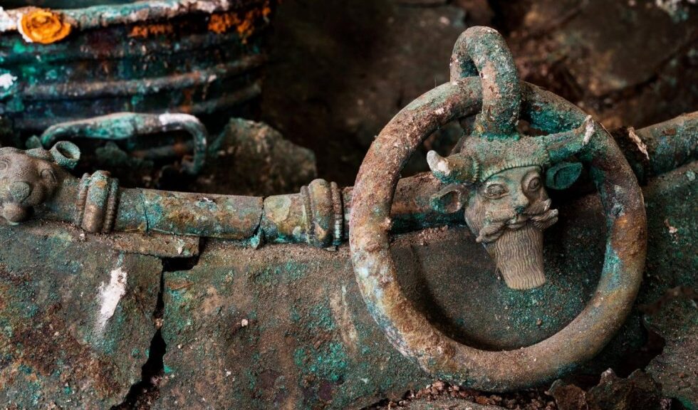
Lavau Celtic Prince: 2,500-year-old royal tomb starts to reveal its secrets
The eastern village of Lavau became world-renowned when archeologists found the tomb of the ancient Celtic prince from the 5th century BCE.
As it is now known, the tomb of the Prince of Lavau holds many mysteries that archaeologists have sought to uncover during the last two years. Some of the stunning artifacts recovered next to the deceased have now be sent to a French lab for analysis – and the first results are starting to emerge.
A number of objects, including the prince’s belt, appear to be extremely valuable as they are unique. Other artifacts bear witness to the cultural exchanges which took place at the time between different civilizations.
A lucky discovery
Archaeologists from the National Institute of Preventive Archaeology (INRAP) were asked to search a site on the outskirts of Lavau, in the heart of a small business industrial park, before construction works could be given the go-ahead.
After finding well-preserved Greek and Etruscan artifacts, the French state ordered a more detailed exploration of the area.
The tomb was found near the village of Lavau, France.
The archaeologists ended up discovering beautiful artifacts from the 5th century BCE, starting with a bronze cauldron ornamented with the head of the god Dionysus.
The remains of the prince were found a little later, laid out on his chariot. The skeleton was still wearing the same fine gold jewellery he was buried with.
This was considered to be the most important archaeological discovery made in France in recent decades – comparable to the 1953’s discovery of grave belonging to the so-called ‘Lady of Vix’.
Thie huge bronze cauldron is one of the most important pieces found in the tomb.
Archaeologists have started to document some of the artifacts, using X-ray radiography and tomography as well as 3D photography to gather information about their composition and morphology – and to learn more about their state of conservation.
Elaborate objects in a multicultural world
So far, X-ray radiography shows that the belt worn by the prince is decorated with threads of silver, assembled together to form Celtic motifs. This is a unique object, as none similar has ever been recovered elsewhere before.
Furthermore, an analysis of the metals in the bronze cauldron – one of the most elaborate artifacts recovered from the grave – suggests that the people who created it perfectly mastered smelting and engraving techniques.
More importantly, perhaps, 3D photography and chemical analyses of the objects reveal influences from different cultures in the way they were decorated. For instance, a large jar used to pour wine is made up of Greek-style ceramic and decorated with golden Etruscan motifs and silver Celtic designs.
This beautiful Greek vase found in the cauldron with the prince was used to pour wine.
These findings reveal that cultural and economic interactions were taking place between the Celtic and Mediterranean worlds at the time the Lavau Celtic Prince was alive.
Analyses will go on until 2020, to try and find out more about the prince’s identity and to learn more about the origins of all the objects he had taken with him in the afterlife.
Already, the researchers have solved one of the most important mysteries they had been confronted with after discovering the tomb – they showed that the deceased was indeed a prince and not a princess. While golden jewels recovered on the skeleton could have belonged to a female, the shape of the pelvic bones suggest he was a male.
The Lavau Prince rests on his chariot with gold jewels.
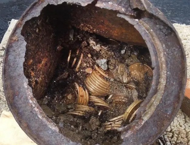
A California Couple Found $10 Million In Gold Coins In Their Backyard
After all, a California couple who have discovered a $10 million cache of hidden gold coins may not be so lucky The coins may have been stolen from the U.S. Mint in 1900 and thus be the property of the government, according to a published report.
A search of the Haithi Trust Digital Library provided by Northern California’s fishery guide Jack trout, who is also a historian and collector of rare coins, brought up the news of theft on the website of the San Francisco Chronicle.
The anonymous California couple spotted the edge of an old can on a path they had hiked many times before several months ago. Poking at the can was the first step in uncovering a buried treasure of rare coins estimated to be worth $10 million.
This image provided by the Saddle Ridge Hoard discoverers via Kagin’s, Inc., shows one of the six decaying metal canisters filled with 1800s-era U.S. gold coins unearthed in California by two people who want to remain anonymous.
“It was like finding a hot potato,” the couple told coin expert Don Kagin from Kagin’s, Inc. The couple hired the president of Kagin’s, Inc. and Holabird-Kagin Americana, a western Americana dealer and auctioneer, to represent them.
The coins are mostly uncirculated and in mint condition, and they add up in face value to $27,000. “Those two facts are a match of the gold heist in 1900 from the San Francisco Mint,” the newspaper reported.
Jack Trout told the paper that an 1866 Liberty $20 gold piece without the words “In God We Trust” was part of the buried stash, and the coin may fetch over $1 million at auction because it’s so rare.
A California couple found 1,427 Gold-Rush era U.S. gold coins in their yard when they were out walking their dog last year. The collection — valued at $11 million
“This was someone’s private coin, created by the mint manager or someone with access to the inner workings of the Old Granite Lady (San Francisco Mint),” Trout told the newspaper. “It was likely created in revenge for the assassination of Lincoln the previous year (April 14, 1865). I don’t believe that coin ever left The Mint until the robbery. For it to show up as part of the treasure find links it directly to that inside job at the turn of the century at the San Francisco Mint.”
Mint spokesman Adam Stump issued this statement when contacted by ABC News: “We do not have any information linking the Saddle Ridge Hoard coins to any thefts at any United States Mint facility. Surviving agency records from the San Francisco Mint have been retired to the National Archives and Records Administration (NARA), under Record Group 104. When news of the stash first broke, coin dealer Kagin spoke about the rarity of such a find.
“Since 1981, people have been coming to us with one or two coins they find worth a few thousand dollars, but this is the first time we get someone with a whole cache of buried coins… It is a million to one chance, even harder than winning the lottery,” Kagin told ABCNews.com.
The couple is trying to remain anonymous after finding the five cans of coins last spring on their Tiburon property in northern California and conducted an interview with Kagin.
“I never would have thought we would have found something like this. However, in a weird way I feel like I have been preparing my whole life for it,” the couple said.
“I saw an old can sticking out of the ground on a trail that we had walked almost every day for many, many years. I was looking down in the right spot and saw the side of the can. I bent over to scrape some moss off and noticed that it had both ends on it,” they said.
It was the first of five cans to be unearthed, each packed with gold coins.
“Nearly all of the 1,427 coins, dating from 1847 to 1894, are in uncirculated, mint condition,” said Kagin told ABCNews.com.
He said that the couple plan to sell most of the coins, but before they do, they are “loaning some to the American Numismatic Association for its National Money Show, which opens Thursday in Atlanta.”
“Some of the rarest coins could fetch as much as $1 million apiece,” said Kagin. He also said that they wish to sell 90 percent of the collection through Amazon.com and on the company’s website.
“We’d like to help other people with some of this money. There are people in our community who are hungry and don’t have enough to eat. We’ll also donate to the arts and other overlooked causes. In a way, it has been good to have time between finding the coins and being able to sell them in order to prepare and adjust. It’s given us an opportunity to think about how to give back,” said the couple.
Kagin and his colleague David McCarthy, senior numismatist, and researcher at Kagin’s, met with the couple last April, two months after the hoard was found.
When McCarthy and Kagin told the couple that their bonanza will be in the annals of numismatic stories for quite some time, the couple said, “It would have been quite a pity not to share the magnitude of our find. We want to keep the story of these coins intact for posterity.”
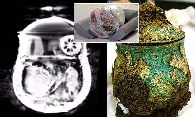
Scans of Viking pot reveal hidden brooches, gold ingots, and beads
Since researchers conducted a CT scan of the old artefact, the mystery around the contents of a Viking pot has been resolved. Archaeologists had been unable to open the pot to see what was inside, but its weight suggested it was full of treasure.
Experts were unable to open the 9th-century Carolingian pot (pictured), which was found on church land in Dumfries and Galloway in September
After undergoing a series of scans, the 1,200-year-old pot was found to contain up to at least five silver brooches and an ornate bead. It was among more than 100 objects discovered by metal detectorist Derek McLennan.
Other items include solid gold jewellery, armbands, and silver ingots. The find was deemed one of the most significant Viking hoards ever discovered in the UK, but the pot’s contents were a mystery.
Experts were concerned about damaging the 9th-century Carolingian pot when attempting to see what was inside. But now, the CT scanner at Borders General Hospital, Scotland, has revealed the ornate box contains around 20 silver, gold, and ivory items.
Mr McLennan, a retired businessman, said the latest discovery was ‘beautiful and exciting’.
‘It brought it all back to me when I saw what was inside the pot,’ he continued. I was like a kid looking in the sweet shop window unable to touch anything being on the other side of the glass.
‘Nothing else had been on my mind for two-and-half-months than seeing what was inside the pot, and then seeing it, there was a rush of emotion and was incredibly exciting. I was absolutely amazed by what was inside the pot. There seem to be 20 plus artifacts in the pot, while most of them seem to be broaches of some sort.
‘It’s a real mishmash of artifacts. Not everything comes across clear as there are different types of metal in there. There is hopefully something beautiful and exciting to look at when it comes out because [the owner] took the time to wrap these items.
‘I’m now waiting on the pot to be emptied, but I understand these things take time and it’s in the hands of the experts.’ A scan of the Carolingian pot was conducted by Dr. John Reid, a consultant radiographer at the BGH, who is also a keen amateur archaeologist.
Experts used a CT scanner to inspect what is inside the Viking pot. The circular shape in the upper right corner is said to be an ornate bead. The dome object to its left is a bone or ivory bead, and the coil curling from the bottom left to the center is five brooches. But the rectangular shape at the center remains a mystery
Derek McLennan, who found the trove, was approached by Richard Welander, head of collections with Historic Scotland, who was aware of the previous use of the hospital’s CT scanner for research. With the permission of the hospital chief, the pot was brought in for an evening scanning session (pictured)
He was approached by Richard Welander, head of collections with Historic Scotland, who was aware of the previous use of the hospital’s CT scanner for archaeological research. With the permission of hospital chief Calum Campbell, the pot was brought in for an evening scanning session.
‘This work takes place outwith normal hours and in no way impedes the important work we do for our human patients,’ said Dr. Reid. The scanner is both rapid and accurate, with the ability to produce 120 visual slices, and is accurate to within half a millimeter.’
The monitoring screen revealed the presence of five silver broaches, smaller gold ingots and ivory beads coated with gold – all wrapped in organic material, possibly leather.
Dr. Reid added: ‘The conservationists did not want to [grope] about and compromise this precious object. The discovery was made in early September by Mr. McLennan. Fellow metal detectorists Reverend Dr. David Bartholomew, who is a Church of Scotland minister of a rural Galloway charge, and Mike Smith, the pastor of an Elim Pentecostal Church in Galloway were also in the vicinity at the time.
The protected pot is shown being scanned in Borders General Hospital. The CT scanner consists of an X-ray tube that rotates around the object. These rays are received by a detector on the opposite side of the object, and an image of the scan is created. It produces 120 visual ‘slices’, and is accurate to within half a millimeter
Rev Dr. Bartholomew said: ‘We were searching elsewhere when Derek initially thought he’d discovered a Viking gaming piece.
‘A short time later he ran over to us waving a silver arm-ring and shouting ‘Viking’! It was tremendously exciting, especially when we noticed the silver cross lying face-downwards.
‘It was poking out from under the pile of silver ingots and decorated arm-rings, with a finely wound silver chain still attached to it.
The discovery was made in early September by retiree Derek McLennan. I was made on the Church of Scotland land, but the exact location hasn’t been revealed. A gold ring found in the hoard is pictured
An early medieval cross was also found among the hoard of Viking treasure. The cross is engraved with decorations that experts claim are highly unusual, and which finder Mr. McLennan believes may represent the four Gospels
‘It was a heart-stopping moment when the local archaeologist turned it over to reveal rich decoration on the other side.’
The hoard falls under the Scots law of treasure trove and is currently in the care of the Treasure Trove Unit. The law states that a reward must be made to the finder, and the reward is judged equivalent to the market value of the items. The Church of Scotland General Trustees, as the landowners, have reached an agreement with Mr McLennan about an equitable sharing of any proceeds, which will eventually be awarded.
The location of the find is not being revealed.
The Scottish Government, Treasure Trove Unit, and Historic Scotland are all involved in ensuring the area is properly protected while the full historical significance of the site is established.