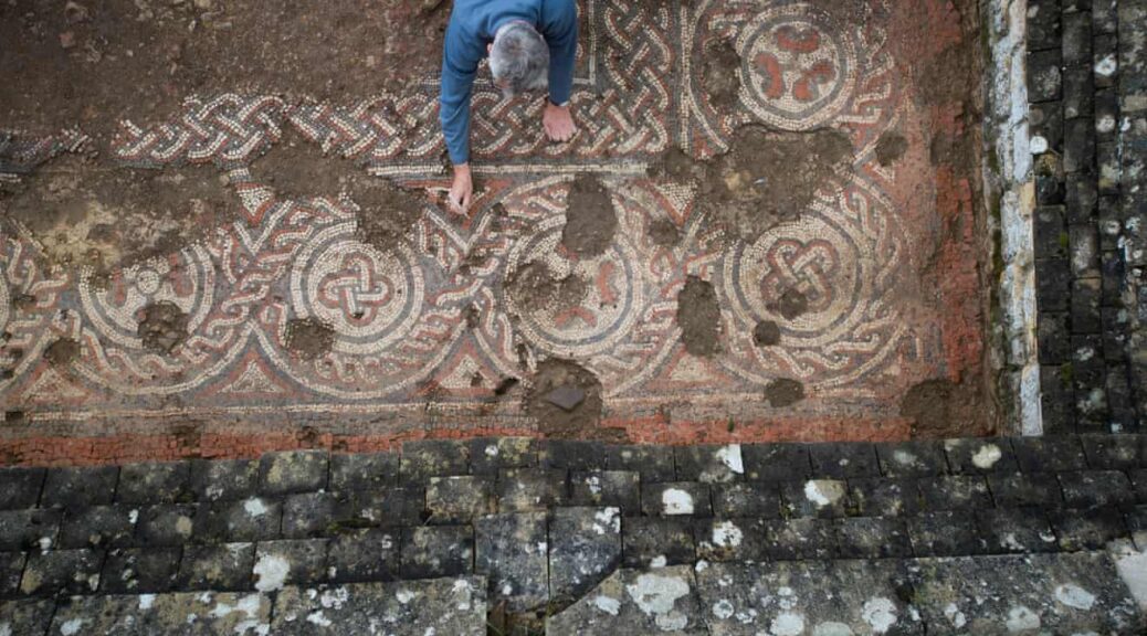
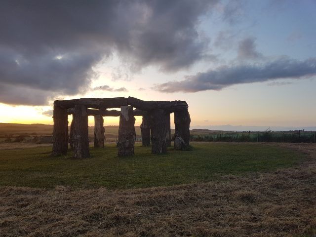
Stunning dark ages mosaic found at Roman villa in Cotswolds
In Britain, life at the beginning of the dark ages is commonly perceived to be a fairly uncomfortable period, an epoch of trouble and misery with the expulsion of Roman rulers leading to economic misery and cultural stagnation.
But a stunning discovery at the Chedworth Roman villa in the Cotswolds suggests that some people at least managed to maintain a rich and sophisticated lifestyle.
National Trust archaeologists have established that a mosaic at the Gloucestershire villa was probably laid in the middle of the fifth century, years after such homes were thought to have been abandoned and fallen into ruin.
The mosaic, found in what may have been a summer dining room, is not quite as splendid as the ones at the villa dating to Roman times, but it seems to show the residents were clinging on to a very decent standard of living.
Martin Papworth, a National Trust archaeologist, said the find was hugely exciting. He said: “The fifth century is a time which marks the beginning of the sub-Roman period, often called the dark ages, a time from which few documents survive, and archaeological evidence is scarce.”
Four hundred years of Roman rule ended in Britain in about 410AD. Papworth said: “It has generally been believed that most of the population turned to subsistence farming and, after the break with Rome, Britannia’s administrative system broke down into a series of local fiefdoms.
Aerial view of the mosaic.
“What is so exciting about the dating of this mosaic at Chedworth is that it is evidence for a more gradual decline.
The creation of a new room and the laying of a new floor suggests wealth, and a mosaic industry continuing 50 years later than had been expected.”
The fifth-century mosaic is of an intricate design. Its outer border is a series of circles alternately filled with flowers and knots. It is of poorer quality than the fourth-century ones found at the villa and others like it.
There are several mistakes, suggesting the skills of the craftspeople were being eroded. But it is nevertheless an attractive floor.
The identities of the people living at the villa in this era are lost in the mists of time. “They could have been dignitaries, people with money, influence, and friends in high places,” said Papworth.
He suggested it was also possible that the area was not so badly affected by hostile raids that were taking place in the north and east.
“It is interesting to speculate why Chedworth villa’s owners were still living in this style well into the fifth century. It seems that in the West Country, the Romanised way of life was sustained for a while.”
It was possible to date the mosaic thanks to traces of carbon found in a trench dug to build a wall to create the room the mosaic was found in.
Dating the carbon strongly suggested the wall was built between 424 and 544 AD. The mosaic was laid in the newly created room after the wall was built.
Stephen Cosh, who has written about Britain’s known Roman mosaics, said: “I am still reeling from the shock. It will be important to research further sites in the region to see whether we can demonstrate a similar refurbishment at other villas which continued to be occupied in the fifth century. But there is no question that this find at Chedworth is of enormous significance – it’s tremendously exciting.”
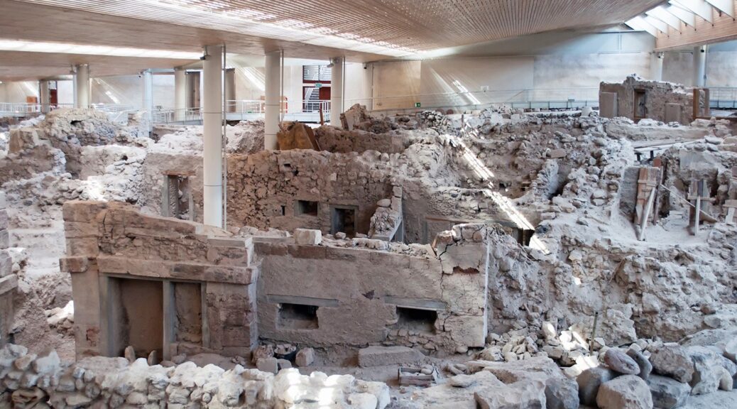
The ancient buried city of Akrotiri, Santorini: Greece Pompeii
The ruins of a Bronze Age sophisticated settlement that thrived centuries before being eradicated by a major volcanic eruption are tucked away from the southern tip of Santorini.
The remains of the Minoan town of Akrotiri are remarkably well preserved, like the Roman ruins of Pompei. In the middle of the second millennium BC, the settlement erupted, when Thera sat on a volcano, and its people fled.
The volcanic matter enveloped the entire island of Santorini and the town itself, preserving the buildings and their contents, and visitors can still identify houses and pots.
The archaeological site of Akrotiri.
The settlement of Akrotiri is one such site. Unlike Pompeii, however, no literary evidence for the destruction of Akrotiri is available to us. As a matter of fact, the city was only discovered by an archaeological excavation conducted in 1967.
Akrotiri was a Bronze Age settlement located on the southwest of the island of Santorini (Thera) in the Greek Cyclades. This settlement is believed to be associated with the Minoan civilization, located on the nearby island of Crete, due to the discovery of the inscriptions in Linear A script, as well as similarities in artifacts and fresco styles.
The earliest evidence for human habitation of Akrotiri can be traced back as early as the 5 th millennium B.C. when it was a small fishing and farming village. By the end of the 3 rd millennium, this community developed and expanded significantly.
One factor for Akrotiri’s growth may be the trade relations it established with other cultures in the Aegean, as evidenced in fragments of foreign pottery at the site. Akrotiri’s strategic position between Cyprus and Minoan Crete also meant that it was situated on the copper trade route, thus allowing it to become an important center for processing copper, as proven by the discovery of molds and crucibles there.
Remarkably preserved artifacts are revealed from the ruins of ancient Akrotiri, Greece.
Akrotiri’s prosperity continued for about another 500 years. Paved streets, an extensive drainage system, the production of high-quality pottery, and further craft specialization all point to the level of sophistication achieved by the settlement. This all came to an end, however, by the middle of the 2 nd century B.C. with the volcanic eruption of Thera. Although the powerful eruption destroyed Akrotiri, it also managed to preserve the city, very much like that done by Vesuvius to Pompeii.
The volcanic ash has preserved much of Akrotiri’s frescoes, which can be found in the interior walls of almost all the houses that have been excavated in Akrotiri. This may be an indication that it was not only the elites who had these works of art.
The frescoes contain a wide range of subjects, including religious processions, flowers, everyday life in Akrotiri, and exotic animals. In addition, the volcanic dust also preserved negatives of disintegrated wooden objects, such as offering tables, beds, and chairs.
This allowed archaeologists to produce plaster casts of these objects by pouring liquid Plaster of Paris into the hollows left behind by the objects. One striking difference between Akrotiri and Pompeii is that there were no uninterred bodies from in the former. In other words, the inhabitants of Akrotiri were perhaps more fortunate than those of Pompeii and were evacuated before the volcanic dust reached the site.
Plaster castings of the corpses of a group of human victims of the 79 AD eruption of the Vesuvius, found in the so-called “Garden of the fugitives” in Pompeii. No such remains exist at Akrotiri, indicating the people had time to evacuate.
‘Spring flowers and swallows’ detailed in a delicate Akrotiri fresco
In 2016, Russian cybersecurity expert Eugene Kaspersky gave archaeologists interested in excavating Akrotiri a huge economic boost by funding three major projects at the ancient site. This is how he explained his reason for financial support:
“What I find magical about Akrotiri and the decades-long, ongoing archaeological research is the sense of an unpredictable past. The fact that following a volcano eruption 3,500 years ago, we modern people are trying to comprehend how these people lived back then. And I believe that we have plenty to discover. Do you think that 3,500 years from now anyone will be interested in finding out how we lived?”
The eruption of Thera also had an impact on other civilizations. The nearby Minoan civilization, for instance, faced a crisis due to the volcanic eruption. This is debatable, however, as some have speculated that the crisis was caused by natural disasters occurring prior to the eruption of Thera.
The short term climate change caused by volcanic eruption is also believed to have disrupted the ancient Egyptian civilization. The lack of Egyptian records regarding the eruption may be attributed to the general disorder in Egypt during the Second Intermediate Period.
Nevertheless, the available records speak of heavy rainstorms occurring in the land, which is an unusual phenomenon. These storms may also be interpreted metaphorically as representing the elements of chaos that needed to be subdued by the Pharaoh.
Some researchers have even claimed that the effects of the volcanic eruption were felt as far away as China. This is based on records detailing the collapse of the Xia Dynasty at the end of the 17th century B.C., and the accompanying meteorological phenomena. Finally, the Greek myth of the Titanomachy in Hesiod’s Theogony may have been inspired by this volcanic eruption, whilst it has also been speculated that Akrotiri was the basis of Plato’s myth of Atlantis.
Thus, Akrotiri and the eruption of Thera serve to show that even in ancient times, a catastrophe in one part of the world can have repercussions on a global scale, something that we are more used to in the better-connected world of today.
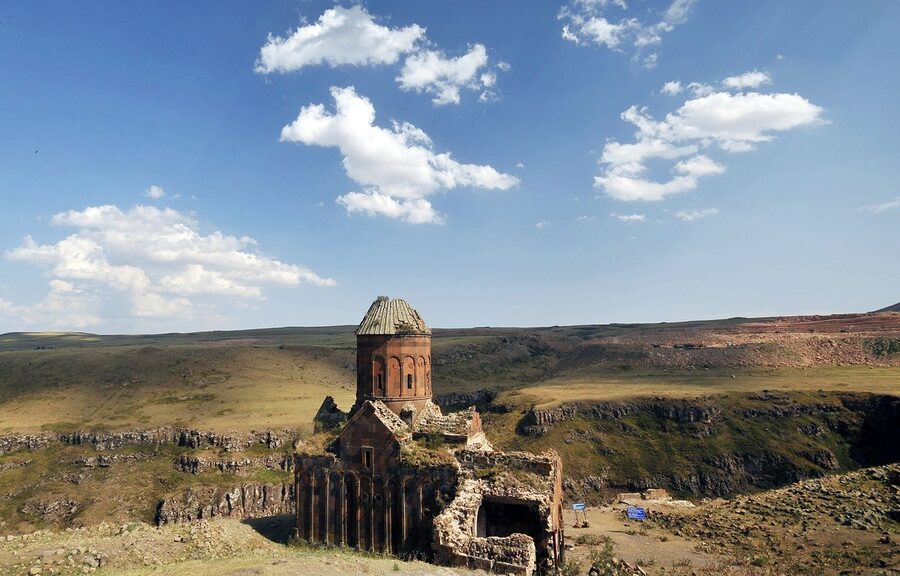
This abandoned site was once the ‘City of 1,001 Churches’
You know that heavy feeling you get when you see an ancient site or ruin and can almost feel all the lives that have passed through it and try to imagine it in all its former glory? Well, look no further than Ani, a medieval Armenian city on the Turkish border, deemed worthy of being called a treasure of world cultural heritage when UNESCO recognized it as such in the early hours of July 15, 2016.
Once a hustling and bustling commercial center on a branch of the ancient Silk Road, sitting at the crossroads of other trade routes that flowed into the heart of Anatolia, Ani now lies off the beaten track – deserted and exotic in all its remoteness.
As with many other important archaeological sites, Ani, too, was built high on a secluded hilltop on fertile volcanic tuff, not far from a nearby water source. With deep-running gorges to its east and west that acted as natural borders and a great defense, the area was the perfect place to call home, once upon a time.
The Monastery of the Hripsimian Virgins, in the ruins of the city of Ani,The monastery is thought to have been built between 1000 and 1200 AD, near the height of Ani’s importance and strength. The Akhurian River below acts as the modern border between Turkey and Armenia.
The first people to settle in the area did so around 3000 B.C., setting up camp on the banks of the emerald green Akhurian River (locally known as Arpaçay).
From the outside, the city seems like a fortress to many, with majestic walls saluting visitors, their sheer expanse growing ever-so overwhelming upon entrance through the Lion Gate but inside lies a different world.
A Military warning sign with the Citadel behind, in Ani
If you were expecting perfectly preserved grandiose buildings that have stood the test of time, you are likely to be very disappointed. Time, nature, earthquakes, and people through wars and invasion have not been kind to Ani, and it shows. It is run down, it is forgotten but that’s what makes it different. It reeks of history. It carries that daunting air that makes you question your very existence, with the ruins of the city crumbling under the heaviness of all the countless experiences of Saka Turks, Sassanids, the Byzantines, Georgian Atabegs, Seljukians, Ottomans, and Russians, just to name a few.
It is deemed a “world city” and the cradle of civilizations and rightly so – it bore witness to 23 civilizations and dynasties throughout the centuries.
Ani saw its best times and expanded greatly when it became the capital of the Bagratid Kingdom of Armenia in the 10th and 11th centuries, growing to a population of about 200,000 at its peak, much larger than London at the time.
The ancient city shows its multicultural fabric in every square inch. From the Seljuk geometric wall patterns to frescoes and elaborate carvings, the influences of Armenian pagan rituals as well as Christian and Muslim religious traditions are evident in the city of tolerance.
Ani, as viewed from across the border, in Armenia.
Still a hidden gem
The city exudes authentic beauty throughout all of the seasons. In winter, under a blanket of pristine snow, it looks like a long-lost frozen kingdom, in autumn it looks mystique and broody, hiding secrets awaiting to be discovered.
Once warmer weather comes round, it almost springs back to life, growing more verdant with every raindrop and filling you up with a sense of adventure that doesn’t come with many historic European sites choked by hordes of tourists.
Thanks to its remote location, once you step in the ruins, it gives you this rush that makes you feel like you’re the first people to (re)discover such profound age in a long time.
All the structures in Ani were built using local volcanic basalt, which was easy to carve, a functional insulator, and came in many vibrant colors such as rosy reds and jet blacks. Not all of the buildings are situated on the central route used by guides or explorers nor are they easily accessible, and the usual half-day trips give you nowhere near enough time to explore every single one scattered across the plateau. So if you’d like to take it all in, it’s best to set aside a few days.
The largest building standing in Ani is the cathedral. A rather Gothic looking structure with novel features such as pointed arches and a now nonexistent dome, the cathedral is an impressive piece of Armenian architecture.
Its importance as a house of God was preserved even when it changed hands throughout history, becoming the first place where Muslim prayers were held in Anatolia after the Seljuk’s momentous victory in the Battle of Manzikert (1071), which opened up the gates of Anatolia to the Turks.
The cathedral, however, was greatly damaged in a devastating earthquake in 1319 as well as during the Mongol invasion, events that marked the beginning of the city’s great decline. By the time the 17th century rolled around, the city was left desolate.
There are numerous other sanctuaries and structures in the city that shed light on the past. The Ebul Menucehr Mosque, the first Turkish mosque on Anatolian soil, the churches of Amenaprgich (the Holy Savior Cathedral), Tigran Honentz (the Church of St. Gregory) and Abugamir Pahlavuni (the Church of the Holy Redeemer), in addition to countless monasteries and chapels dotting the vast meadows, are just a few that have contributed to Ani’s historical reputation.
The ruined church of the Holy Redeemer
And as if you needed another excuse to catch the nostalgic Eastern Express, to embark on your journey to the ancient archaeological site of Ani all you need is to hop on that train from Ankara. Once you arrive in Kars’ city center, it’s up the hills we go by car or bus, over bends and rocks for about 42 kilometers, passing flocks of sheep and herds of cows, where the famous Kars gruyere comes from, slowly leaving behind city life to step back in time.
Oldest fossils on Earth discovered in 3.7bn-year-old Greenland rocks
According to recent research, tiny sediment ripples on an ancient seafloor, captured inside a 3.7 billion-year-old rock in Greenland, possibly the earliest fossils of living organisms ever found on Earth.
The research, led by Allen Nutman, head of the School of Earth and Environmental Sciences at the University of Wollongong in Australia, described the discovery of what looks like tiny waves, 0.4 to 1.5 inches (1 to 4 centimeters) high, frozen in a cross-section of the surface of an outcrop of rock in the Isua Greenstone Belt in southwestern Greenland, a formation made up of what geologists regard as the oldest rocks on the Earth’s surface.
The researchers said the ripples are the fossilized remains of cone-shaped stromatolites, layered mounds of sediment, and carbonates that build up around colonies of microbes that grow on the floor of shallow seas or lakes.
According to the scientists, the new discovery, detailed online today in the journal Nature, supports theories that life on Earth originated during the so-called Hadean eon more than 4 billion years ago, a period of intense volcanic activity when large meteorites and icy comets frequently bombarded Earth. This was also the time when the first bodies of water formed on the planet’s surface.
The rock outcrop was found only after a series of warm summers in southwestern Greenland caused large patches of snow at the site to melt earlier than normal, revealing rocks that had not been examined by researchers since the Isua Greenstone Belt was first explored in the 1980s, Nutman told Live Science.
The stromatolites in figure a are from Greenland; those in c and d are younger stromatolites from Western Australia. Figure b shows the layers created by microbes as they formed the Greenland stromatolites (blue lines). ‘Storms’ are several overlapping stromatolites.
“Most of the rocks there are very deformed and modified by later mountain-building processes, but you do find just very tiny little areas that have survived with their original volcanic or sedimentary structures not destroyed,” Nutman said. “But this is the first one of the surviving structures where we actually have stromatolites.”
Under pressure
Remarkably, the structures were found in an outcrop of metamorphic rock that was once subject to intense underground heating and pressure, which distorted their original shapes and changed their chemical composition.
Allen Nutman (left) and Vickie Bennet (right) with a specimen of 3.7-billion-year-old stromatolites from Isua, Greenland
“The overall features, such as the shape of the stromatolites, are preserved,” Nutman said. “But some of the finer details of the very fine layering have certainly been erased — although, as we show in the paper, there are vestiges of that left.”
Sediment structures that look like stromatolites can form without the involvement of microbial life, but the researchers said they examined the chemistry and minerals in the rocks and were able to establish that they contain the fossilized remains of a colony of ancient microbes.
The 3.7-billion-year-old structures described in the new study are about 220 million years older than the fossils previously regarded as the oldest known fossils on Earth. Those 3.5-billion-year-old stromatolites, found in sedimentary rocks in Western Australia, precipitated over billions of years without metamorphic heating. Abigail Allwood, an astrobiologist at NASA’s Jet Propulsion Laboratory in Pasadena, California, whose 2006 study about the Australian fossils established their biological origin, said the new study will likely face close scrutiny.
“These kinds of discoveries always do [cause controversy], especially when they first come out, and in this case, it’s particularly amazing because they were found in metamorphic rocks that have been significantly altered and transformed from their original characteristics,” Allwood told Live Science.
Allwood reviewed the new study by Nutman and his colleagues for a separate opinion piece published in the journal Nature. Allwood’s 2006 study is cited in the new paper, but she did not contribute directly to the latest research.
“It’s remarkable that they have found [the structures], and they’ve done a good job of analyzing what’s there — but the alteration that the rocks have seen means that there’s just a whole lot of stuff that you’d typically like to see to make such an extraordinary claim, that just isn’t preserved,” she said.
Life or nonlife?
Geochemist Balz Kamber, chair of geology and mineralogy at Trinity College Dublin in Ireland, has also studied the stromatolite fossils from Western Australia. He told Live Science that the new finds would no doubt face further scientific tests to assess the strength of the claims for a biological origin. But he added that the new structures appear to be a far better prospect for evidence of ancient life than another set of fossils reported nearly two decades ago on Greenland’s Akilia Island, which were later shown not to have a biological origin.
Kamber also said there can be little doubt that the conical structures identified in the new research are the result of sedimentation on the floor of a marine environment, regardless of whether they can be shown to have a biological origin. This means that the structures are not only evidence of standing bodies of water on the Earth’s surface 3.7 billion years ago, but also bodies of land crossed by rivers that carried chemical solutes into the ancient oceans, he said.
Both Kamber and Allwood also said the new findings have implications for the field of astrobiology and the search for evidence of past life on other planets — particularly on Mars. Kamber said these potential clues about the very early emergence of life on Earth in the Hadean period supports his own recent research, published earlier this year, about the prospects for life in the water-filled craters caused by meteorite and comet impacts on the early Earth.
“I think the enclosed impact basins at the tail end of the bombardment at 3.8 [billion] to 3.85 billion years ago would have made great places for life to emerge from,” he said.
Allwood added that there is also clear evidence that, at the time the rocks at Isua were forming 3.7 billion years ago, conditions on Mars were similar to those on early Earth.
“[T]here were similar environments in bodies of water standing at the surface of Mars, offering a similar kind of environment to the ones that hosted the early evidence of life on Earth, at Isua and younger,” she said.
Until now, there had been a gap between the start of the fossil record on Earth and the youngest areas on Mars, where there was good evidence for standing bodies of water in the past.
“And you had to imagine that life could have arisen there before they dried up — but now at least we may have one example in the fossil record showing us that life can arise that quickly,” Allwood said.
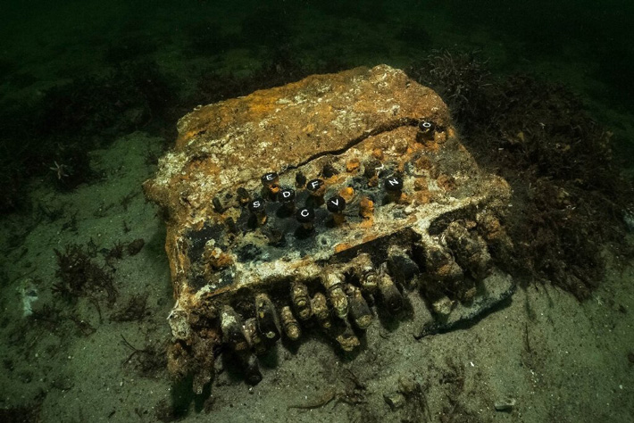
World War II–Era Code Machine Recovered from Baltic Sea
From the bottom of the Baltic Sea in Europe, three-quarters of a century after it was lost at the end of the Second World War, one of the most famous puzzles on the planet has been recovered.
A mechanical encryption device that once confounded the Allies while allowing Adolf Hitler’s Nazis to make battle plans in secret, German divers say they have dredged up a long-lost Enigma machine.
The typewriter-like machine was found on the seafloor of Gelting Bay in northeast Germany, where divers were working to collect old fishing nets on behalf of the World Wildlife Federation.
The Enigma cipher machine was discovered on the seabed in Gelting Bay near Flensburg, Germany.
It’s believed the Nazis tossed the device overboard in an attempt to destroy it in the final days of the war, as part of an effort to keep German technology out of the Allies’ hands.
Divers initially thought the object was an old typewriter, but underwater archaeologist Florian Huber says he recognized it after it was brought up to the surface.
“I’ve made many exciting and strange discoveries in the past 20 years,” he told Reuters. “But I never dreamed that we would one day find one of the legendary Enigma machines.”
While searching for abandoned fishing nets, German divers discovered this Enigma machine in the Baltic Sea.
The Enigma machine was essentially an encrypted typewriter that allowed the Germans to send and receive messages without fear of them being intercepted and decoded by the enemy.
The Nazis used the machines to coordinate their war efforts for years, thanks to a shifting encryption process that would change every 24 hours.
British cryptographers worked tirelessly to decode the encrypted messages at Bletchley Park.
Legendary mathematician Alan Turing is widely credited with finally cracking the code in 1941, which allowed the Allies to spy on German communications in the latter days of the war. The breakthrough came after Britain seized an Enigma machine from a captured German sub.
The codebreakers’ work is thought to have helped end the war and save thousands of lives. It also inspired the Oscar-nominated film The Imitation Game in 2014.
Huber says the Enigma machine found in Gelting Bay was likely lost in May 1945, around the time that the Germans surrendered.
German forces were ordered to sink approximately 50 of their own submarines in Gelting Bay at the end of the war, in an effort to prevent the subs from being captured. Crews were also specifically instructed to destroy the Enigma machines on board.
“We suspect our Enigma went overboard in the course of the event,” said Huber, who works for an underwater research firm called Submarines.
The divers have decided to donate the device to a museum where it can be restored and put on display.
Surviving Enigma machines are rare in 2020, although examples can be found at museums scattered across the world, including Canada. The restoration process for the new discovery is expected to take about a year.
The archaeological excavations that happened at Perdigões complex in the Evora District of Portugal recently showed that the archaeological excavations uncovered a “unique structure in the Prehistory of the Iberian Peninsula”. In fact, nothing similar has ever been found in Portugal before now.
Only one-third of the circle has been excavated so far, so archaeologists created this projection to give a better sense of its size. The portion that has been excavated is shown on the far left. Archaeologists estimate the circle to be about 66 feet (20 meters) in diameter.
“As described by António Valera, who was the archaeologist in charge of the excavations, the Perdigões structure was a prehistoric ceremonial site found in the middle of a complex of 12 ditch enclosures and “articulates with the visibility of the megalithic landscape that extends between the site and the elevation of Monsaraz, located to the east, on the horizon.
The site was used for religious ceremonies, burials, and rituals as several pits with sacrificial items had been recovered.
People would travel long distances to attend ceremonies and festivals at the location which was a good way for them to socialize and strengthen their bonds with each other.
Woodhenge at North Newnton.
The circular-shaped structure has been nicknamed “Woodhenge” in reference to Stonehenge except this one was made from wood.
“A possible access to the interior of this structure is oriented towards the summer solstice, reinforcing its cosmological character,” Valera explained, adding, “this situation is also known in other European countries as ‘wood henges’ and ‘timber circles’, where astronomical alignment entrances are frequent, underlining the close relationship between these architectures and the Neolithic views of the world .”
It has been described as a “monumental wooden construction, of which the foundations remain, with a circular plan and more than 20 meters in diameter,” Valera noted.
While this “Woodhenge” is the first of its kind to be found in Portugal, it is incredibly similar to other structures found in the central part of Europe and the British Isles – like Stonehenge.
This may indicate that the people of Perdigões were in communication with those living in locations far from them and that those living across Europe were much more connected with each other during the Neolithic period than previously thought.
Woodhenge is the wooden version of Stonehenge.
The complex dates back from around the end of the Middle Neolithic Period (about 3400 BC) to the start of the Bronze Age period (around 2000 BC) – a time frame that lasted approximately 1,400 years.
This time period brings up the possibility that the ancient Bell Beaker culture may have constructed “Woodhenge” as they are believed to have originated in Portugal and their culture thrived from around 3500 BC to 2500 BC.
The timber circles date back 4,500 years.
Valera finished off by stating the importance of finding this structure, “discovery reinforces the already high scientific importance of the Perdigões enclosure complex in the international context of European Neolithic studies while increasing its heritage relevance,” which was recognized as a National Monument in 2019. Several pictures of “Woodhenge” can be seen here.
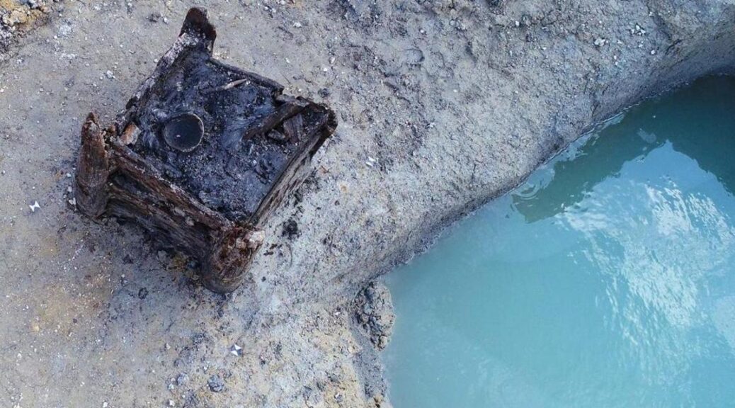
7,000-year-old well is the oldest wooden structure ever discovered
In what is now the Czech Republic, archaeologists have found a 7,000-year-old well built by Neolithic settlers. Researchers determined it to be the oldest wooden architectural building in the world after studying the structure.
The structure was first uncovered by construction workers in 2018 in Ostrov, between the regions of Bohemia and Moravia.
The growth rings in the wood, a method known as dendrochronology, were studied by archaeologists and concluded that it was made from oak cut down around 5255 B.C.
Now test results that rely on both radio-carbon dating and the much more precise dendrochronological method, which studies the tree ring sequences in wood, have narrowed down the age to either 5,256 or 5,255 BC.
Experts at the University of Pardubice plan to preserve the well, which is currently being stored in a climate-controlled cellar at the school, located east of Prague.
“It is by far the oldest object that we will be working on at the faculty, and it will not be an easy task,” Karol Bayer, Vice-Dean of the Faculty of Restoration at the university, said in a statement.
This 7,000-year-old well has been confirmed by researchers to be the oldest wooden structure ever discovered.
Bayer said the structure was well-preserved because it remained underwater for centuries. The preservation process will now take several months to complete, to ensure the wooden pieces do not fall apart after drying.
“Now we cannot let it dry out, or the well would be destroyed,” Bayer said. “That is why we will gradually replace the water with a new preservative that each of us knows and uses. It is saccharose. So we will increase the concentration of the sugar solution,”
The well measures about 55 inches in height, with a square base of about 32 by 32 inches. The design reveals that Neolithic people were capable of more advanced architectural techniques than previously thought.
The structure, built with grooved corner posts with inserted planks, also highlights the builders’ advanced carpentry abilities — unknown across the continent during the Neolithic period, the later portion of the Stone Age.
The structure was said to be constructed with the “utmost precision” even though the only tools available at the time consisted of stone, bone, horn, and wood.
“The shape of the individual structural elements and tool marks preserved on their surface confirm sophisticated carpentry skills,” the researchers said.
During a preliminary analysis, experts found evidence of many invertebrate animals and small vertebrate bones, shellfish, crustacean eggs, and insects.
Researchers were also able to deduce some information on the environment and economy of these farmers after identifying the residue of crop plant species, including prehistoric wheat, flax, and opium poppy.
This well is the third Neolithic well found in the country in four years.
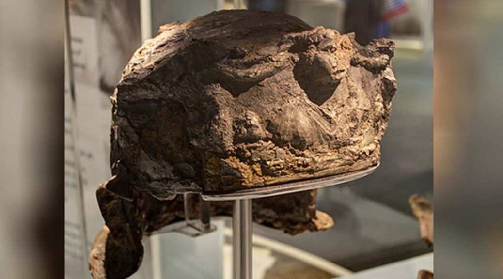
The 2,000-year-old Hallaton helmet is the only Roman helmet ever Found in Britain
At the British Museum, a silver-gilt Roman helmet of excellent quality and world value found as part of the Hallaton Treasure and ArtFunded in 2007 was returned to its former glory.
The discovery was purchased by the Leicestershire County Council for exhibition at the Harborough Museum and the helmet was restored and repaired with the expertise at the British Museum due to Heritage Lottery funding.
Discovery
Archaeologists who made the original discovery at Hallaton in Leicestershire, used to finding more glamorous gold and silver coins, joked they had found a fairly modern “rusty bucket”. Little did they know at the time what a hugely significant archaeological find they had come across.
The “Hallaton Helmet” was found ten years ago by members of the Hallaton Fieldwork Group and professional archaeologists from the University of Leicester Archaeological Services who were excavating the remains of a 2,000-year-old Iron Age shrine.
The site appears to be a major religious center, having produced the largest number of Iron Age coins ever excavated in Britain and possible evidence of ritual feasting dating to the mid-1st century AD.
The helmet would probably have been designed for ceremonial occasions
The finds from this site would later become known as the Hallaton Treasure.
On display
The helmet was too fragile to be excavated in situ so it was removed within a block of earth held together with plaster of Paris.
It was taken to the British Museum in London for conservation, which took nine years of work by conservator Marilyn Hockey and her colleagues Fleur Shearman and Duygu Çamurcuoğlu.
Corrosion and the effects of time had shattered the helmet into thousands of pieces, most of which were smaller than the nail on a person’s little finger. The reconstructed and conserved helmet was unveiled in January 2012.
Leicester County Council was able to raise £1 million to buy the entire hoard and pay for the conservation of the helmet, with the assistance of donations from the Heritage Lottery Fund (which gave a £650,000 grant), the Art Fund and other trusts and charities.
The helmet was valued at £300,000; under the terms of the Treasure Act, Ken Wallace and the landowner were each awarded £150,000.
The helmet was put on permanent public display at the end of January 2012 at the Harborough Museum in Market Harborough, nine miles from the site where the hoard was found, alongside other objects found at Hallaton.