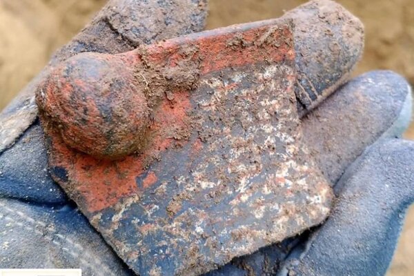
19th-century beer bottles found under the staircase in England
WYAS Archeological Services made the finding back in February and subsequently sent out the bottles for analysis.
The team discovered a set of cellar stairs in the ruins of what was the Scarborough Castle Inn after investigating an area within the site of the former Tetley’s Brewery.
Neatly piled on the stairs was a collection of over 600 bottles, initially thought to contain ginger beer.
But it was discovered that the bottles were filled with alcohol and, even more, high concentrations of lead after the samples were sent for review by West Yorkshire Joint Services.
In a social media post, archaeological services WYAS said that the bottles contained 5.07 pH beer with 3% ABV alcohol. However, the liquid contained 0.13mg/l of lead, far above the WHO-recommended safe level in water of around 0.01mg/l.
Researchers analyzed hundreds of old beer bottles discovered in the United Kingdom.
The team said they suspect the high metal content would have come from lead pipes, and that the beer “would have been detrimental to health”.
The bottles themselves hail from a number of different breweries, with the most from ‘J. E. Richardson of Leeds’. The archaeologists hope to complete their work in the area in the next two weeks, after which they will compile a report of their findings.
Speaking to the drinks business, senior project manager at Archaeological Services WYAS, David Williams, said that the team thought the bottles dated to the later 19th century, “perhaps the 1880s”.
He added that the developer, Vastint, intends to keep the bottles and make a feature of them within the new development of the former Tetley’s Brewery.
“This excavation is giving us a great opportunity to uncover a part of Georgian and Victorian Leeds. The results so far are giving a real insight into the daily lives of the former residents of Leeds during this period,” he said.
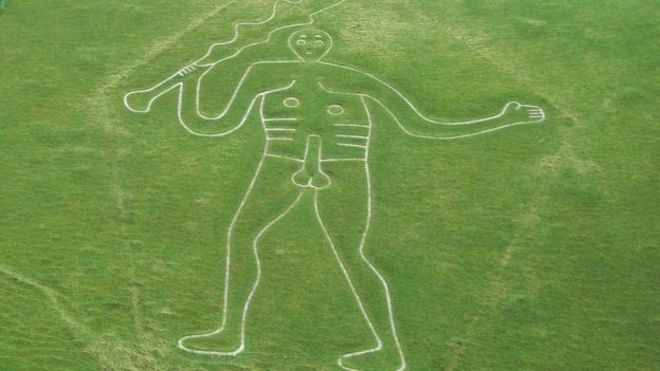
Tests Underway to Solve Enigma of Naked Cerne Abbas Giant
For the first time, archaeologists attempt to establish the age of the mysterious Cerne Abbas Giant. The Cerne Abbas Giant is a 55 m nude chalk figure brandishing a giant club overlooking Cerne Abbas village in Dorset, England.
The origins and purpose of Britain’s largest chalk hill figure remain shrouded in mystery. The giant chalk figure was gifted to the National Trust in 1920 by the Pitt-Rivers family.
The charity and Gloucestershire University also conduct research to determine the age of the giant. Archeologists have excavated small trenches to enable samples of soil to be extracted from points on the giant’s elbows and feet.
An aerial view of the Cerne Abbas Giant, a hill figure near the village of Cerne Abbas in Dorset
A closer aerial view showing the hillside on which the giant is carved into which was gifted to the National Trust in 1920 by the Pitt-Rivers family. The charity is now researching the giant
Professor Phillip Toms from Gloucestershire University will attempt in the coming weeks to date the samples using a technique called optically stimulated luminescence (OSL).
Martin Papworth, a senior archaeologist at the National Trust, said: ‘The OSL technique is commonly used to determine when mineral grains in the soil were last exposed to sunlight.
‘It was used to discover the age of the Uffington White Horse in Oxfordshire in the 1990s, which was found to be nearly 3,000-years-old – even more ancient than we had expected.
‘We’re expecting the results of the tests in July. It is likely that the tests will give us a date range, rather than a specific age, but we hope they will help us better understand, and care for, this famous landmark.’
Volunteers from the National Trust cleaning and restoring the giant for the first time in 2019
Volunteers working to repair and refresh the Cerne Abbas Giant in Dorset. Archaeologists are attempting to determine for the first time the age of the mysterious Cerne Abbas Giant
Gordon Bishop, chairman of the Cerne Historical Society, said villagers were eagerly awaiting the results.
‘Although there are some who would prefer the giant’s age and origins to remain a mystery, I think the majority would like to know at least whether he is ancient or no more than a few hundred-years-old,’ he said.
‘Whichever may be the case, he is unique.’
In a separate analysis, environmental archaeologist Mike Allen will analyze soil samples containing the microscopic shells of land snails to learn more about the site’s past.
‘There are 118 species of snails in Britain and many of them are habitat-specific, so their preserved shells can help us establish what a landscape was like at a certain time, and to track changes in land use over time,’ he said.
‘They should help us to discover whether the giant was created on a grazed chalk hillside, or whether people purposely cleared scrub to prepare the land for the figure.’
Last year, the giant was refreshed for the first time in 11 years, with a team of volunteers hammering in 17 tonnes of new chalk by hand to counteract weathering and keep the giant visible for miles around.
Theories as to the purpose of the giant are unclear. Everything from it being an ancient spirituality symbol or likeness of Greco-Roman hero Hercules to a caricature of Oliver Cromwell, with the club a reference to repressive rule and the phallus a mockery of his puritanism, have been put forward as suggestions.
Local folklore has long held it to be a fertility aid and the earliest recorded mention of the giant dates from 1694.
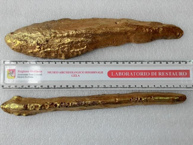
Orichalcum, the lost metal of Atlantis, may have been found on a shipwreck off Sicily
A group of naval archeologists has uncovered two hundred ingots spread over the sandy seafloor near a 2,600-year-old shipwreck off the coast of Sicily. The ingots were made from orichalcum, a rare cast metal that ancient Greek philosopher Plato wrote was from the legendary city of Atlantis.
A total of 39 ingots (metal set into rectangular blocks) were, according to Inquisitr, discovered near a shipwreck. BBC reported that another same metal cache was found. 47 more ingots were found, with a total of 86 metal pieces found to date.
The wreck was discovered in 1988, floating about 300 meters (1,000 ft) off the coast of Gela in Sicily in shallow waters. At the time of the shipwreck Gela was a rich city and had many factories that produced fine objects. Scientists believe that the pieces of orichalcum were destined for those laboratories when the ship sank.
Sebastiano Tusa, Sicily’s superintendent of the Sea Office, told Discovery News that the precious ingots were probably being brought to Sicily from Greece or Asia Minor.
Tusa said that the discovery of orichalcum ingots, long considered a mysterious metal, is significant as “nothing similar has ever been found.” He added, “We knew orichalcum from ancient texts and a few ornamental objects.”
2,600-year-old shipwreck found off the coast of Sicily
According to a Daily Telegraph report, the ingots have been analyzed and found to be made of about 75-80 percent copper, 14-20 percent zinc and a scattering of nickel, lead, and iron.
The name orichalucum derives from the Greek word oreikhalkos, meaning literally “mountain copper” or “copper mountain”. According to Plato’s 5th century BC Critias dialogue, orichalucum was considered second only to gold in value, and was found and mined in many parts of the legendary Atlantis in ancient times
Plato wrote that the three outer walls of the Temple to Poseidon and Cleito on Atlantis were clad respectively with brass, tin, and the third, which encompassed the whole citadel, “flashed with the red light of orichalcum”.
The interior walls, pillars, and floors of the temple were completely covered in orichalcum, and the roof was variegated with gold, silver, and orichalcum. In the center of the temple stood a pillar of orichalcum, on which the laws of Poseidon and records of the first son princes of Poseidon were inscribed.
The orichalucum ingots found off the coast of Gela in Sicily.
For centuries, experts have hotly debated the metal’s composition and origin.
According to the ancient Greeks, orichalcum was invented by Cadmus, a Greek-Phoenician mythological character. Cadmus was the founder and first king of Thebes, the acropolis of which was originally named Cadmeia in his honor.
Cadmus, the Greek mythological figure who is said to have created orichalcum
Orichalcum has variously been held to be a gold-copper alloy, a copper-tin, or copper-zinc brass, or a metal no longer known. However, in Vergil’s Aeneid, it was mentioned that the breastplate of Turnus was “stiff with gold and white orachalc” and it has been theorized that it is an alloy of gold and silver, though it is not known for certain what orichalcum was.
The breast plate of Turnus was said to be made with gold and white ‘orachalc’’ ‘The Fight between Aeneas and King Turnus’ by Giacomo del Po, Italy, Naples, 1652-1726.
Orichalcum is also mentioned in the ‘Antiquities of the Jews’ (1 st century AD) – Book VIII, sect. 88 by Josephus, who stated that the vessels in the Temple of Solomon were made of orichalcum (or a bronze that was like gold in beauty).
Today, some scholars suggest that orichalcum is a brass-like alloy, which was made in antiquity the process of cementation, which was achieved through the reaction of zinc ore, charcoal and copper metal in a crucible.
The latest discovery of the orichalcum ingots that had laid for nearly three millennia on the seafloor may finally unravel the mystery of the origin and composition of this enigmatic metal.
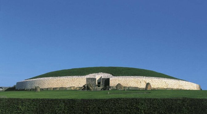
Newgrange: The Massive Irish Tomb That’s Older Than The Pyramids
Yep, 5,000 years. That’s older than Stonehenge. It’s older than the great Egyptian pyramids, too. And five millennia later, it hasn’t lost any of its wonders.
Newgrange was built around 3200 B.C. — hundreds of years before the Great Pyramid of Giza (2500 B.C.) and Stonehenge (3000 B.C.).
The massive hemispherical tomb is located in the Brú na Bóinne – Gaelic for the “palace” or “mansion” of the River Boyne. This 3-square mile area contains nearly a hundred ancient monuments, including two other large tombs, in addition, Newgrange, Knowth and Dowth.
A map of megalithic monuments in the Brú na Bóinne
Arriving at the iconic tomb is a wow-moment, to say the least. Standing outside the 80-meter mound, shored up with spiral-engraved kerbstones and topped with white Wicklow quartzite, a guide reveals the myths and history behind the monument. Newgrange could have been designed as a tomb or a temple – in reality, nobody knows which. The truth will be shrouded in mystery forever.
Let there be light…
Once the scene has been set for you as a visitor, you’ll step inside the passage tomb itself, squeezing through standing stones carved with spiraling rock art and graffiti dating back to the 1800s (before Newgrange was taken into State care).
Ducking under beams of wood, you’ll emerge into the cool confines of a cruciform-shaped chamber like a stony igloo squirreled away within a hill.
The engraved stone at the entrance to Newgrange.
This inner sanctum is where a lucky few (chosen by lottery from thousands of applicants annually) huddle together to witness the annual winter solstice illumination.
The illuminated inner corridor of Newgrange.
At this moment, when megalithic engineering and nature lock sensationally into sync, a shaft of light can be seen snaking 19 meters up the passageway, ultimately bathing the chamber in light. There are goosebumps, to say the least…
If you’re not one of the lucky ones, don’t fret. All visitors are treated to a simulated solstice, with an orange beam of light artificially showcasing the effect. It’s a tantalizing little taster – little wonder legend suggests that this was the site where mythological hero Cú Chulainn was Born.
Subterranean secrets…
A young girl stands in front of the entrance to Newgrange in about 1905
Newgrange isn’t the only passage tomb in Ireland, of course. In fact, it’s not the only passage tomb at Brú na Bóinne. Together with nearby Knowth and Dowth, Newgrange has declared a Unesco World Heritage Site in 1993. Not bad for a site that once looked destined to become a quarry!
Not far away, near Oldcastle, County Meath, you’ll find a lesser-known cluster of passage tombs. Spotted around a handful of hills at Loughcrew are several cairns also dating from around 3,200BC. Because they’re more obscure and harder to get to, the Indiana Jones effect is all the more titillating.
If you get the sense that you’re being watched here, you may well be right. Some 60km away, atop of Slieve Gillian in County Armagh, the passage of another tomb points directly back towards Loughcrew.
Slieve Gillian’s two cairns lie on either side of a summit lake, with the southern tomb said to have a winter solstice alignment at sunset. On a good day, the views stretch as far as Dublin Bay.
The native Picts, a Celtic-language speaking tribe, once populated the Scottish Islands, similar to the natives that live on what is now Scotland.
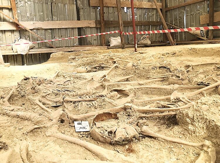
Archaeologists and volunteers are working to preserve human bones exposed by recent storms in an ancient cemetery above a beach on the Orkney Islands.
Several powerful storms on Scotland’s Orkney Islands have now revealed ancient human remains in a Pictish and Viking cemetery dated back to about 1,500 years ago.
To order to protect the damage to the former Newark Bay cemetery on Orkney’s largest island, volunteers are now placing sandbags and clay around. The site dates from the middle of the sixth century when ancient Pictish people inhabited the Orkney Islands.
The site is currently being protected by sandbags.
Picts or Norse?
The cemetery was used for about 1,000 years, and numerous burials from the ninth to the 15th century were Norsemen or Vikings who had seized the Orkney Islands from the Picts. Now, storm waves are destroying the low cliff where the ancient site is located, Peter Higgins from the Orkney Research Center for Archaeology (ORCA), said.
“Every time we have a storm with a bit of a south-easterly [wind], it really gets in there and actively erodes what is just soft sandstone,” Higgins explained.
Approximately 250 skeletons were taken out of the cemetery about 50 years ago, but researchers do not know how far the site extends from the beach. They believe that hundreds of Pictish and Norse bodies are still buried there.
“The local residents and the landowner have been quite concerned about what’s left of the cemetery being eroded by the sea,” Higgins said.
Uncovered bones are usually either coated with clay to protect them or removed from the site after their positions are thoroughly labeled, so it is rather unusual for bones to end up on the beach, he explained.
Researchers do not know yet of the exposed bones belong to Picts or Vikings, as no burial objects or funeral clothes were spotted, and the bodies were buried four of five layers under the surface.
Cultural Transition
Historians claim that the first Norse immigrants to the Orkney Islands established there in the late eighth century, leaving a rising new monarchy in Norway. They used the Orkney Islands to begin their own voyages and Viking raids, and ultimately, all the islands were ruled by the Norse, according to The Scotsman.
The relationship between the Picts and the Norse on the Orkney Islands is highly argued by scholars. They cannot know for sure whether the Norse took over by force, or were settlers who traded and entered marriage with the Picts. However, now, the ancient cemetery at Newark Bay may help researchers answer their questions.
“The Orkney Islands were Pictish, and then they became Norse,” Higgins said. “We’re not really clear how that transition happened, whether it was an invasion, or people lived together. This is one of the few opportunities we’ve got to investigate that.”
A part of the scientific work on the remains would require testing genetic material from the ancient bones, which might demonstrate that some people living on the Orkney Islands today are successors of people who lived there more than 1,000 years ago.
The scientific study of bones from the ancient cemetery at Newark Bay could reveal clues to the cultural transition from Pictish to Norse domination of the Orkney Islands.
“We’re fairly confident that we’re going to find that some local residents are related to people in the cemetery,” Higgins said.
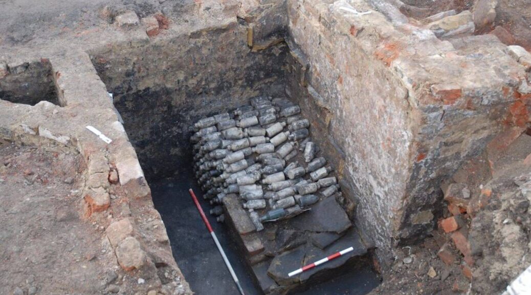
Trnava archaeologists made a 6,000-year-old discovery
Ceramic fragments found under the fortification wall prove the skilfulness of the Lengyel culture.
In Trnava’s Zelený Kríček settlement pit, archeologists found several decorated ceramics fragments, antler tools and fragments of stone tools older than 6,000 years.
The investor is building a polyfunctional object near the gallery and the research, according to its head, Andrej Žitňan, uncovered an object which could be a part of the larger settlement discovered four years ago at Františkánska Street.
An archaeological discovery in Trnava
The discovery is located outside the middle age center of the town just in front of the town’s fortification wall.
“Its existence until these days is a matter of lucky circumstances because it was preserved in the narrow area between the wall and filled town ditch,” said Peter Grznár of the Regional Monument Board in Trnava, as quoted by the TASR newswire
The finding dates back to the Neolithic Age, more specifically to the era of the Lengyel culture. Grznár said that the discovery contributes to the knowledge about the settlement of Trnava following the significant findings of the locality near Františkánska and Štefánikova Street.
So-called Trnava Venuses were also found here; they are the oldest artistic display ever found in the town’s area with an estimated age of 6,700 to 6,800 years.
Archaeologist Žitňan said that the Neolithic settlement was wider than expected based on the previous findings because all surrounding lands are already built-up.
“Ceramic fragments found under the fortification wall have beautiful decorations. They prove the skilfulness of the Lengyel culture,” he said, as quoted by TASR
Remains of Ottoman soldiers unearthed after 108 years
The corpses of 30 Ottoman soldiers are discovered in Istanbul’s neighborhood. Rahmi Asal of the Istanbul Archeology Museums Department said the men had served in the Balkan War’s 86th Ottoman Army Battalion.
A mass grave belonging to soldiers who died while serving in the Ottoman Army’s 86th Regiment in what is today an Istanbul suburban district during the Balkan War has been unearthed.
Thirty soldiers ‘ graves were discovered in Çatalca during excavations carried out prior to the “Martyrdom Museum” project proposed by the Istanbul Archeology Museums Directorate.
The names of five of the Ottoman seals on the soldiers who were buried with their clothes were identified.
Museum director Rahmi Asal said dead soldiers were hidden in their belts with spoons and pouches. The remaining items from the soldiers were classified by the museum directorate.
These findings include officer seals with many uniform buttons and belts, belt buckles, one compass, many tobacco layers and cigarette holders, bayonets, many mirrors, and two rings.
Some names were also reached from the seals that came out of five of the soldiers determined to be the officers of the 86th Regiment from their collar numbers.
Mehmet Nuri, Necmettin and Osman Binveli, three of the dead soldiers, are believed to have been officers in their division.
The two killed soldiers buried a little away from others were Daniel and Avedis, non-Muslim Ottoman officers who fought against Bulgarian soldiers.
In the Balkan War in 1912, the Ottoman state entered the war against the revolting states of Bulgaria, Greece, Serbia, and Montenegro.
As the invaders advanced to Çatalca, soldiers from all over the country started fighting to stop them. The soldiers who set out from the southern province of Antalya’s Alanya district also walked on the roads for days and joined the troops on the front.
Alaiye (Alanya) Reserved Battalion, consisting of Alanians from the 86th Regiment, repelled the enemy and began to rest by deploying in positions around Dağyenice village.
Bulgarian soldiers infiltrating the positions attacked the Alaiye Battalion and slaughtered 657 Ottoman soldiers overnight. After this painful incident that occurred on the night of November 17, 1912, this hill started to be known as “Alaiye Martyrdom.”
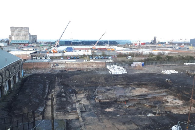
Traces of 18th-Century Glass Factory Uncovered in Scotland
Interesting traces of Leith’s glass-making past are being uncovered as preparatory works to construct a new residential development gather steam.
The City of Edinburgh Council lodged proposals by Barratt Homes to develop 212 new apartments plus commercial units on a former industrial land stretch near Leith Docks at Salamander Lane. two years ago and are currently at the consultation stage.
Work is already underway to prepare the site ahead of full planning approval, with a number of buildings that were once home to Garland and Roger Ltd timber yard and a six-metre-high boundary wall cleared at the start of the year.
Workers and archaeologists are now starting to uncover traces of an almost extinct Leith industry which has flourished for centuries and was even responsible for the naming of the road on which it was situated.
There was evidence of the once enormous glasswork in Salamander Lane, which can trace its origins from more than two and a half centuries to 1747.
Remnants of the Edinburgh and Leith Glass Works, which can trace its roots back to the 1740s, have been uncovered.
Aerial photographs show the re-emergence of what’s left of one of the glassworks’ six huge furnace cones as well as a number of other buildings, including workshop and warehouse remains.
The furnace cones measured between 80 and 100 feet in height with a diameter of around 40 feet at the base. The brick-built sixsome towered above the Leith skyline at the time and could be easily spotted from the slopes of Calton Hill more than two miles away.
Archaeologists are currently on-site examining the glassworks buildings and deep layers of ancient beach sand deposits that have been exposed as a result of the excavation. John Lawson, the City of Edinburgh Council’s Archaeologist, said his team is hopeful of uncovering important artefacts during the dig.
Remains of one of the glassworks’ six furnace cones (right-hand side of image) are now visible from above.
He said: “Archaeological investigations have just started on the site which once housed the nationally significant Edinburgh and Leith Glass Works and formed an iconic element of Leith’s industrial skyline.
“It is hoped that the excavations will reveal important evidence as to its development since it moved to this site in the mid 18th Century.”
This image taken by Thomas Begbie in the 1850s captures two of the glassworks’ furnace cones.
From the 14th century onwards, Leith boasted trading links with Europe and the world, importing and exporting a wide range of shipments. Alcohol was among the most sought after produce being brought in and the harbour was regularly flooded with casks and barrels of fine French wine, sweet Spanish sherry and Portuguese port.
Leith’s growing whisky industry and Edinburgh being a burgeoning centre for medicine meant an increasing demand for glass products, further underlining the need for a dedicated glassware and bottling works. As chance would have it, the old port was the perfect home for such an industry as the district boasted substantial quantities of sand and kelp – both of which were essential in glass manufacturing during the Georgian era.
Following the opening of earlier works elsewhere at Leith Citadel and in Edinburgh, the first furnace at what would become the Edinburgh and Leith Glass Works on Salamander Street was fired up in 1747. The works opened on the border of what was then Leith Sands, which, for more than 200 years, was home to Scotland’s main horse racing event, the infamous Leith Races.
A total of six giant, brick-built cones had risen from the site by 1783 and would continue to belch out fire and smoke for the best part of the next century. The amphibian-sounding Salamander Street appeared on maps in the early 19th century and was even coined, it is thought, as an allusion to the glass-making industry – the salamander being supposedly fire-proof, according to medieval legend.
At its height, the glassworks had a lot of bottles, producing in excess of one million glass vessels per week – but it wouldn’t last forever. Editions of The Scotsman dating from 1874 record that the dissolution of the Edinburgh and Leith Glass Works Company occurred in December of that year.
The site was put up for lease and the entire plant, stock and materials of the glassworks, which included a 6-horse power horizontal steam engine; a grinding mill; a “first-class nearly new” turning lathe; and all manner of pot-boards; tank rings and “bottle moulds of ever variety from flasks to carboys”, were listed for auction.
Local Blue Badge tourist guide and historian Fraser Parkinson says he hopes chiefs of the ongoing residential development are respectful of the history being uncovered.
He said: “The glass making industry had a strong footing in Leith until the second half of the 19th century, so it is really exciting to be able to view the footprint of the old glass making buildings and especially the foundations of the old cones which could be seen from Calton Hill.
“It’s a brief but appreciated glimpse back in time. Let’s hope that the developers make good recordings of what is unearthed before moving onto Leith’s future buildings.”
The last of the glass works’ furnace cones was demolished in 1912. The timber yard of Garland & Rogers Ltd filled the space in the decades that followed, as one by one Leith’s traditional industries slowly began to disappear.


![Scottish storms unearth 1,500-year-old Viking-era cemetery Scottish Islands were once inhabited by native Picts people only, a Celtic-language speaking group, similar to the natives that live on what is now Scotland. Some powerful storms on the Orkney Islands in Scotland have now unearthed ancient human bones in a Pictish and Viking cemetery dated back to about 1,500 years ago. Volunteers are now placing sandbags and clay around, in order to protect the damage to the ancient Newark Bay cemetery on Orkney’s largest island. The site is dating back to the middle of the sixth century when the Orkney Islands were occupied by native Pictish people. Picts or Norse? The cemetery was used for about 1,000 years, and numerous burials from the ninth to the 15th century were Norsemen or Vikings who had seized the Orkney Islands from the Picts. Now, storm waves are destroying the low cliff where the ancient site is located, Peter Higgins from the Orkney Research Center for Archaeology (ORCA), said. “Every time we have a storm with a bit of a south-easterly [wind], it really gets in there and actively erodes what is just soft sandstone,” Higgins explained. Approximately 250 skeletons were taken out of the cemetery about 50 years ago, but researchers do not know how far the site extends from the beach. They believe that hundreds of Pictish and Norse bodies are still buried there. “The local residents and the landowner have been quite concerned about what’s left of the cemetery being eroded by the sea,” Higgins said. Uncovered bones are usually either coated with clay to protect them or removed from the site after their positions are thoroughly labeled, so it is rather unusual for bones to end up on the beach, he explained. Researchers do not know yet of the exposed bones belong to Picts or Vikings, as no burial objects or funeral clothes were spotted, and the bodies were buried four of five layers under the surface. Cultural Transition Historians claim that the first Norse immigrants to the Orkney Islands established there in the late eighth century, leaving a rising new monarchy in Norway. They used the Orkney Islands to begin their own voyages and Viking raids, and ultimately, all the islands were ruled by the Norse, according to The Scotsman. The relationship between the Picts and the Norse on the Orkney Islands is highly argued by scholars. They cannot know for sure whether the Norse took over by force, or were settlers who traded and entered marriage with the Picts. However, now, the ancient cemetery at Newark Bay may help researchers answer their questions. “The Orkney Islands were Pictish, and then they became Norse,” Higgins said. “We’re not really clear how that transition happened, whether it was an invasion, or people lived together. This is one of the few opportunities we’ve got to investigate that.” A part of the scientific work on the remains would require testing genetic material from the ancient bones, which might demonstrate that some people living on the Orkney Islands today are successors of people who lived there more than 1,000 years ago. “We’re fairly confident that we’re going to find that some local residents are related to people in the cemetery,” Higgins said.](https://archaeology-world.com/wp-content/uploads/2020/03/stroms-1.jpg)