The Medieval Woman Who “Gave Birth” In A Coffin
In Italy, a macabre discovery brought insight into two rare medical phenomena from the early Middle Ages.
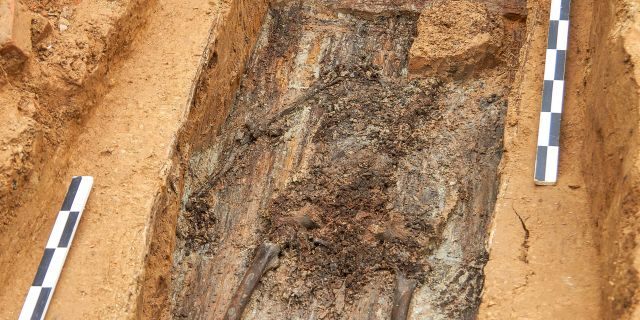
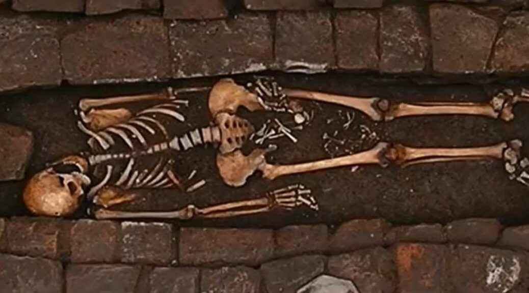
In Imola, Italy, among several burials. The well-preserved remains of an adult laid to rest with the bones of a fetus positioned between the legs were found by archaeologists.
A deeper analysis has now shown that the pair is an unusual case of ‘ coffin birth. ‘

During the funeral both the mother and the child had already died-but, it wasn’t until after that the stillborn baby was pushed from her body.
It remains a mystery how exactly the pregnant woman died hundreds of years ago around the age of 25-35, but markings on her skull indicate she underwent medieval brain surgery at least a week prior, with a hole drilled neatly into her skull.
Researchers from the Universities of Ferrara and Bologna have detailed the grim findings in a paper published to the journal World Neurosurgery.
The procedure exemplified in the burial from the 7th-8th century AD is known as trepanation and is thought to date back to the Neolithic era.
It was used to treat all sorts of ailments by drilling or cutting into the skull – including a pregnancy disorder still common today.
‘Eclampsia is the outcome of seizures of pre-eclampsia, which can affect women after the twentieth week of pregnancy, and hypertensive diseases are still the first cause of maternal death,’ the authors wrote in the study.
‘Some of the most common manifestations of this disease are high fever, convulsions, consistent frontal, and occipital cephalalgia, high intracranial pressure, and cerebral hemorrhage.
‘All these symptoms, from Prehistory to the 20th century, used to be treated with trepanation.’

The nature of the lesion observed in the ancient skull suggests the injury was the result of surgical intervention, rather than violent trauma.
And, the researchers say it even exhibits signs of early bone healing, indicating the woman survived at least a week after the procedure was done. At the time, she was roughly 38 weeks into the pregnancy.
While it’s impossible to know for sure why the trepanation was performed, the researchers say it was likely an attempt to reduce pressure in the skull stemming from eclampsia. How she died is even less certain.
‘There are still several unknown points about the woman’s cause of death,’ the authors explain, noting that she could have died from the pregnancy disorder, labor-related complications, or the surgery itself.

In any case, the researchers say the discovery of both trepanation and coffin birth in the same set of remains is incredibly rare.
‘This finding is one of the few documented cases of trepanation in the European Early Middle Ages, and the only one featuring a pregnant woman in association with a post mortem fetal extrusion phenomenon,’ the authors wrote.
‘Considering all these factors, this case represents a unicum and sheds more light on the clinical history of neurosurgery and pregnancy during this historical period.’