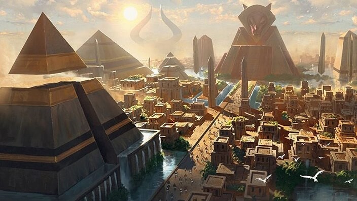
If people in the desert are looking into this for the first time then you should really look at www.snopes.com and see what they think about some of the photos that have been posted on the Internet. So if you looked at the above link, who do you believe? At the bottom of the page on Snopes, you’ll see a link to the square-cube law which purposes that large humans are not possible. Well, I disagree.
They have been found and some are even living today. I’m sure you’ve seen them on TV shown as anomalies to the human race. So what should you take away from all this? Don’t believe everything you read on the Internet. Even Snopes, which some people believe in and follow like a religion, can be wrong.
Now whoever decided the Square-cube law had anything to do with people or animals certainly could never convince me, at least not showing examples of boxes. If you believe this then do you believe there was ever a Mastodon roaming the earth, or how about dinosaurs? Take it all (including this article) with a grain of salt!
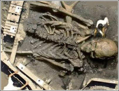
To give you a good example of what we’re talking about here, we’ll dwell for a minute on this one “photo” that is presented in many, many videos on YouTube as evidence of Giant Ancients in the world and in the desert southwest. With a little research, you’ll find that this is a doctored photo that was entered into a contest on a graphics site called Worth1000.
There are many examples of fantastic graphics manipulations on this site. HERE is the original entry.
Someone found this and used it to make bogus claims about the Ancient Giants in the desert. Of course, this may not be the case for some of the information found on the Internet. So what about the archaeologists and anthropologists and their viewpoint on this subject? If you don’t know this then it’s about time you did.
If the artefacts weren’t found by a person with a degree and documented then it doesn’t exist, period! And even if it was found by a person with a degree they are unlikely to verify it. Why, because it goes against all the verified info they have and goes against other more qualified persons.
In other words, they will be ridiculed, so they forget it or write it off as a hoax. This kind of thinking is like the dark ages but continues today in our society of scholars. Would the government acknowledge these findings? Absolutely not. Can you imagine the ramifications to follow? People with Viking backgrounds like myself who have relatives on the Isle of Man could come forth and ask for their land back or payment for it. Plus a lot of other options. So much information is censored because of this it’s no wonder we live like blind people.
Manti, Utah
Let’s look at some of the findings that may or may not support the Giant Ancients in the desert. First here is a finding in the centre of Utah near the town of Manti.
In 1955 a man by the name of John Brewer found a set of stone stairs carved on the floor of a cave near Manti, Utah. After gaining access he discovered a tomb or chamber where he found large coffins and mummies with red and blond hair of very large stature. He also found boxes with metal plates inscribed in an ancient text. He showed this to a friend, Dr Robert Heinerman, PhD in anthropology. No photos exist of the coffins or mummies. Only photos of the plates were taken. Some of the plates were made of gold, some of the copper.
It is told that Mr Brewer found other caves with more artefacts, but no more mummies. He wouldn’t show the cave to anyone else.
It has been rumoured that the LDS church may have had something to do with this decision? Of course, this may be just a rumour. So to this date, there exists no physical proof of this tale. Below is a map for reference so you’ll know where Manti, Utah is located.
Los Angeles, California
This was published in the early 1900s in the San Diego Union Newspaper. There was no follow up on this find. Did the paper just use this for a fill-in or something to boost sales of the paper? The Paiute Indians have a legend about Egyptian-like people with long dark hair that arrived here in sailing ships and made their home in Death Valley in caves near the Panamint Mountains. Could these be the same people?
‘Oh wow’: remarkable Roman mosaic found in Rutland field
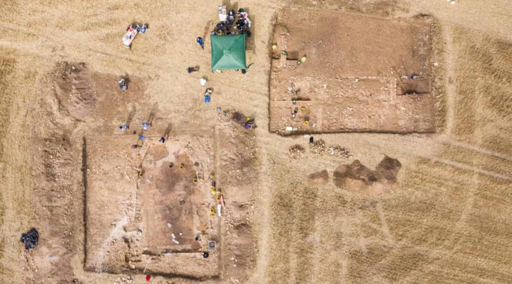
Archaeologists have unearthed the first Roman mosaic of its kind in the UK, a rare Roman mosaic and surrounding villa complex have been protected as a Scheduled Monument by DCMS on the advice of Historic England. The decision follows archaeological work undertaken by a team from the University of Leicester Archaeological Services (ULAS), working in partnership with Historic England and in liaison with Rutland County Council.
The initial discovery of the mosaic was made during the 2020 lockdown by Jim Irvine, son of landowner Brian Naylor, who contacted the archaeological team at Leicestershire County Council, heritage advisors to the local authority. Given the exceptional nature of this discovery, Historic England was able to secure funding for urgent archaeological investigations of the site by ULAS in August 2020. Further excavation involving staff and students from the University of Leicester’s School of Archaeology and Ancient History examined more of the site in September 2021. The remains of the mosaic measure 11m by almost 7m and depict part of the story of the Greek hero Achilles.
The artwork forms the floor of what’s thought to be a large dining or entertaining area. Mosaics were used in a variety of private and public buildings across the Roman Empire, and often featured famous figures from history and mythology. However, the Rutland mosaic is unique in the UK in that it features Achilles and his battle with Hector at the conclusion of the Trojan War and is one of only a handful of examples from across Europe.
The mosaic depicts scenes from Homer’s The Iliad, about the epic fight between Achilles and the Trojan hero, Hector.
The room is part of a large villa building occupied in the late Roman period, between the 3rd and 4th century AD. The villa is also surrounded by a range of other buildings and features revealed by a geophysical survey and archaeological evaluation, including what appear to be aisled barns, circular structures and a possible bathhouse, all within a series of boundary ditches. The complex is likely to have been occupied by a wealthy individual, with a knowledge of classical literature.
Fire damage and breaks in the mosaic suggest that the site was later re-used and re-purposed. Other evidence uncovered includes the discovery of human remains within the rubble covering the mosaic. These burials are thought to have been interred after the building was no longer occupied, and while their precise age is currently unknown, they are later than the mosaic but placed in a relationship to the villa building, suggesting a very late Roman or Early-Medieval date for the repurposing of this structure. Their discovery gives an insight into how the site may have been used during this relatively poorly understood early post-Roman period of history.
Human remains have been found at the site.
Evidence recovered from the site will be analysed by ULAS at their University of Leicester base and by specialists from Historic England and across the UK, including David Neal, the foremost expert on mosaic research in the country.
The protection as a scheduled monument recognises the exceptional national importance of this site. It ensures these remains are legally protected and helps combat unauthorised works or unlawful activities such as illegal metal detecting. The site has been thoroughly examined and recorded as part of the recent investigations and has now been backfilled to protect it for future generations.
The villa complex was found within an arable field where the shallow archaeological remains had been disturbed by ploughing and other activities. Historic England is working with the landowner to support the reversion of these fields to sustainable grassland and pasture use. These types of agri-environment schemes are an essential part of how we can protect both the historic and natural environments and have contributed around £13 million per year towards the conservation and maintenance of our rural heritage. They help to preserve sites like the Rutland mosaic so that people can continue to enjoy and learn about our fascinating history.
In collaboration with the University of Leicester and other stakeholders, Historic England is planning further excavations on the site for 2022.
Discussions are ongoing with Rutland County Council to explore the opportunity for an off-site display and interpretation of the villa complex and its finds. The form and scope of this work will be informed by the proposed future excavations and will be the subject of a future National Lottery Heritage Fund bid.
Image of the full mosaic in situ, displaying three panels (with damage) featuring Achilles.
The site is on private land and not accessible to the public.
John Thomas, Deputy Director of ULAS and project manager on the excavations, said: “This is certainly the most exciting Roman mosaic discovery in the UK in the last Century. It gives us fresh perspectives on the attitudes of people at the time, their links to classical literature, and it also tells us an enormous amount about the individual who commissioned this piece. This is someone with a knowledge of the classics, who had the money to commission a piece of such detail, and it’s the very first depiction of these stories that we’ve ever found in Britain.
“The fact that we have the wider context of the surrounding complex is also hugely significant because previous excavations on Roman villas have only been able to capture partial pictures of settlements like these, but this appears to be a very well-preserved example of a villa in its entirety.”
Jim Irvine, who initially discovered the remains, said: “A ramble through the fields with the family turned into an incredible discovery. Finding some unusual pottery amongst the wheat piqued my interest and prompted some further investigative work. Later, looking at the satellite imagery I spotted a very clear crop mark as if someone had drawn on my computer screen with a piece of chalk! This really was the ‘oh wow’ moment and the beginning of the story.
This archaeological discovery has filled most of my spare time over the last year. Between my normal job and this, it’s kept me very busy and has been a fascinating journey. The last year has been a total thrill to have been involved with and to work with the archaeologists and students at the site, and I can only imagine what will be unearthed next!”
Duncan Wilson, Chief Executive of Historic England, said: “To have uncovered such a rare mosaic of this size, as well as a surrounding villa, is remarkable. Discoveries like this are so important in helping us piece together our shared history. By protecting this site we are able to continue learning from it, and look forward to what future excavations may teach us about the people who lived there over 1,500 years ago.”
Richard Clark, County Archaeologist for Leicestershire and Rutland, said: “This has been the most extraordinary of discoveries, and for that, full tribute must be paid to Jim and his family for their prompt and responsible actions. It has been a privilege to have been involved in the investigation and a pleasure to have worked with such a skilled group of amateurs and professionals. The villa, its mosaic and the surrounding complex is the most outstanding find in the recent archaeological history of Rutland, placing the county on a national and international stage and providing a vivid insight into the life and demise of the local Romano-British elite at a time of remarkable change and upheaval. The final phase of burials is just one of many intriguing aspects to the investigation, suggesting a continuing knowledge and respect for the site in the post-Roman period.”
Nigel Huddleston, Heritage Minister, said: “This fascinating discovery of an elaborate Roman complex in Rutland is helping us to understand more about our history. I’m delighted we have protected this site to help further studies and excavations.”
An aerial view of the archaeological site, photographed by drone.
Professor Nishan Canagarajah, President and Vice-Chancellor of the University of Leicester, said: “It is difficult to overstate the importance of this discovery, and the excitement which it will doubtless provide to countless people; from those well-versed in Roman archaeology to those with perhaps only a passing interest. Having been lucky enough to visit the site myself, and meet some of the Leicester students from our School of Archaeology and Ancient History gaining real-world experience with ULAS on this major project, I witnessed first-hand the thorough but careful work which our archaeologists have undertaken to further our understanding of Roman Britain.”
The discovery of the Rutland villa and filming as the mosaic is uncovered for the first time in 1600 years will be featured as part of Digging for Britain when it returns to BBC Two and iPlayer in early 2022.
Host, Professor Alice Roberts, said: “What I love about Digging for Britain is that, when we set out to film the series, we have no idea what discoveries might come to light. This year, the revelations have been nothing short of spectacular, and each find brings us closer to understanding the lives of people who once lived in Britain. Archaeology brings you into intimate contact with the physical reality of the past.”
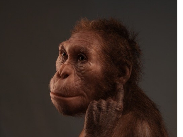
Ancient Human Relative, Australopithecus sediba, “Walked Like a Human, But Climbed Like an Ape”
An international team of scientists has discovered a two-million-year-old fossil vertebrae from an extinct species of ancient human relative. New lower back fossils are the “missing link” that settles a decades old debate proving early hominins used their upper limbs to climb like apes and their lower limbs to walk like humans.
Life reconstruction of Australopithecus sediba com-missioned by the University of Michigan Museum of Natural History.
An international team of scientists from New York University, the University of the Witwatersrand, and 15 other institutions announced today, in the open access journal e-Life, the discovery of two-million-year-old fossil vertebrae from an extinct species of ancient human relative.
The recovery of new lumbar vertebrae from the lower back of a single individual of the human relative, Australopithecus sediba, and portions of other vertebrae of the same female from Malapa, South Africa, together with previously discovered vertebrae, form one of the most complete lower backs ever discovered in the early hominid record and give insight into how this ancient human relative walked and climbed.
The fossils were discovered in 2015 during excavations of a mining trackway running next to the site of Malapa in the Cradle of Humankind World Heritage Site, just northwest of Johannesburg, South Africa. Malapa is the site where, in 2008, Professor Lee Berger from the University of the Witwatersrand and his then nine-year old son, Matthew, discovered the first remains of what would be a new species of ancient human relative named Australopithecus sediba.
Fossils from the site have been dated to approximately two million years before present. The vertebrae described in the present study were recovered in a consolidated cement-like rock, known as breccia, in near articulation.
Australopithecus sediba silhouette showing the newly-found vertebrae (colored) along with other skeletal remains from the species.
Rather than risking damaging the fossils, they were prepared virtually after scanning with a Micro-CT scanner at the University of the Witwatersrand, thus removing the risk of damaging the closely positioned, delicate bones during manual preparation.
Once virtually prepared, the vertebrae were reunited with fossils recovered during earlier work at the site and found to articulate perfectly with the spine of the fossil skeleton, part of the original Type specimens of Australopithecus sediba first described in 2010.
The skeleton’s catalogue number is MH 2, but the researchers have nicknamed the female skeleton “Issa,” meaning protector in Swahili. The discovery also established that like humans, sediba had only five lumbar vertebrae.
“The lumbar region is critical to understanding the nature of bipedalism in our earliest ancestors and to understanding how well adapted they were to walking on two legs,” says Professor Scott Williams of New York University and Wits University and lead author on the paper. “Associated series of lumbar vertebrae are extraordinarily rare in the hominin fossil record, with really only three comparable lower spines being known from the whole of the early African record.”
The discovery of the new specimens means that Issa now becomes one of only two early hominin skeletons to preserve both a relatively complete lower spine and dentition from the same individual, allowing certainty as to what species the spine belongs to.
“While Issa was already one of the most complete skeletons of an ancient hominin ever discovered, these vertebrae practically complete the lower back and make Issa’s lumbar region a contender for not only the best-preserved hominin lower back ever discovered, but also probably the best preserved,” says Berger, who is an author on the study and leader of the Malapa project.
He adds that this combination of completeness and preservation gave the team an unprecedented look at the anatomy of the lower back of the species.
Previous studies of the incomplete lower spine by authors not involved in the present study hypothesised that sediba would have had a relatively straight spine, without the curvature, or lordosis, typically seen in modern humans. They further hypothesised Issa’s spine was more like that of the extinct species Neandertals and other more primitive species of ancient hominins older than two million years.
Lordosis is the inward curve of the lumbar spine and is typically used to demonstrate strong adaptations to bipedalism. However, with the more complete spine, and excellent preservation of the fossils, the present study found the lordosis of sediba was in fact more extreme than any other australopithecines yet discovered, and the amount of curvature of the spine observed was only exceeded by that seen in the spine of the 1.6-million-year-old Turkana boy (Homo erectus) from Kenya and some modern humans.
Australopithecus sediba silhouette showing the newly-found vertebrae along with other skeletal remains from the species. The enlarged detail (a photograph of the fossils in articulation on the left; micro-computed tomography models on the right) shows the newly discovered fossils, in color on the right between previously known elements in grey.
“While the presence of lordosis and other features of the spine represent clear adaptations to walking on two legs, there are other features, such as the large and upward oriented transverse processes, that suggest powerful trunk musculature, perhaps for arboreal behaviors,” says Professor Gabrielle Russo of Stony Brook University and an author on the study.
Strong upward oriented transverse spines are typically indicative of powerful trunk muscles, as observed in apes. Professor Shahed Nalla of the University of Johannesburg and Wits, who is an expert on ribs and a researcher on the present study, says: “When combined with other parts of torso anatomy, this indicates that sediba retained clear adaptations to climbing.”
Previous studies of this ancient species have highlighted the mixed adaptations across the skeleton in sediba that have indicated its transitional nature between walking like a human and climbing adaptations. These include features studied in the upper limbs, pelvis, and lower limbs.
“The spine ties this all together,” says Professor Cody Prang of Texas A&M, who studies how ancient hominins walked and climbed. “In what manner these combinations of traits persisted in our ancient ancestors, including potential adaptations to both walking on the ground on two legs and climbing trees effectively, is perhaps one of the major outstanding questions in human origins.”
The study concludes that sediba is a transitional form of ancient human relative and its spine is clearly intermediate in shape between those of modern humans (and Neandertals) and great apes.
“Issa walked somewhat like a human, but could climb like an ape,” says Berger.
Children’s Teeth Reveal Breastfeeding Practices in Ancient Peru
For thousands of years, breastfeeding habits have remained almost unchanged in the Peruvian Andes, according to an unprecedented research project at an archaeological site in Caral, the oldest civilisation in the Americas and the origin of Andean culture.
There, in a cemetery filled with the bodies of children believed to be buried around 500 B.C., researchers discovered that the way these kids were breastfed was akin to how mothers do it in modern-day rural communities in the Andes.
Tooth analysis of the remains of 48 children showed that the majority were breastfed exclusively for the first six months and were not completely weaned until 2.6 years of age, which is still the case in the most rural and traditional Andean populations.
“We expected a younger age, like in modern times, where due to work issues and social pressures, children are weaned practically at 9 months,” Luis Pezo-Lanfranco, the Peruvian bioarchaeologist leading the study, tells Efe.
Pezo-Lanfranco says that it is very likely intermittent breastfeeding occurred in Caral, the civilization that developed 130 kilometres (over 80 miles) north of Lima between the years 3,000 to 1,800 B.C.
To be sure, researchers need to find a cemetery from that period. A few burial sites from that time in Caral have been recovered but the preservation of bones was too poor to find stable isotopes of carbon, nitrogen and oxygen, which reveal breastfeeding patterns.
Researchers are nevertheless confident that those breastfeeding habits found in infants buried in Chupacigarro ravine cemetery, just a kilometre from the sacred city of Caral, were inherited from the Americas’ first civilization.
“In Caral, many cultural forms were created that are traditional for the Andes,” says Pedro Novoa, deputy director of Caral research and conservation of materials.
While the discovery of a cemetery that would confirm the Caral researchers’ hypothesis has evaded them, indications of the significance that breastfeeding held in this primitive society have been found in several nearby urban centres.
It can be seen in a series of clay statuettes representing women breastfeeding their infants and others who hold their babies in their laps, in an allegory of motherhood discovered in Vichama, one of Caral’s 12 urban centres.
According to the study, it is still not clear whether that long breastfeeding period was a nutritional supplement or was due to food shortages.
Ruth Shady, the director of Caral archaeological investigations, says the high infant mortality may have been due to drought and famine.
“The drought is the main problem they faced, and it is very possible that this was what caused death among these children,” adds Shady, who has been studying Caral since 1994.
Did Another Advanced Civilization Exist On Earth Before Humans?
Graham Hancock is considered a connoisseur when it comes to “advanced human societies before the one we know,” that is, the “mother culture” that preceded later ancient civilizations.
Although the idea of ancient civilizations and their possible technology is considered by some to be “pseudo-scientific”, there are many indications that reveal a possible use of advanced technological mechanisms in the remote past.
If we eliminate the idea of aliens who came to instruct our ancestors, some of the ideas that Hancock has contributed over time remain as a result.
History tells us that human’s pre-primitive achievements were not technically advanced but the megaliths and artefacts and thought processes, as best as can be determined, that appear strangely out-of-sync with what was achieved by our ancient ancestors.
This indicates something that may have preceded what our civilization was capable of and what it accomplished somewhat after about 10,000 B.C.
The underground and underwater structures and some blatant artefacts would seem to have a premise based on the knowledge that was once known, and showing up in situ or in ancient texts that have gone missing because of human destruction or environmental catastrophes: the fire that wiped out the works in the Library of Alexandria (48 BC) or the Eruption of Vesuvius (79 AD), not to mention the great flood registered in ancient texts as a “mythic” event that “destroyed the (known) world.”
T-shaped pillars at Gobekli Tepe are carved with stylized hands, belts and loincloths.
The Göbekli Tepe structures indicate a pre-10,000 society with an interesting, and out-of-sync mindset just before the Sumerian (Mesopotamian) societies appeared, from which we have records and evidence.
If one takes Erich von Däniken’s “theories” in “Chariots of the Gods?” and supplant them, replace them, with Graham Hancock’s thinking, the idea of an earlier, brighter humanity was extant on the Earth, one will have something not as rabid as the ET thesis.
But what could happen to that brilliant and amazing ancient human civilization? It is a very difficult answer to give.
However, as in any society that reaches a high point, problems like environmental adversities, overpopulation, wars, etc. arise.
And although we do not have an answer to this enigma, we can sketch some possibilities by observing the current scenario and complementing it with past findings.
Possibly history repeats itself, the history of our civilization.
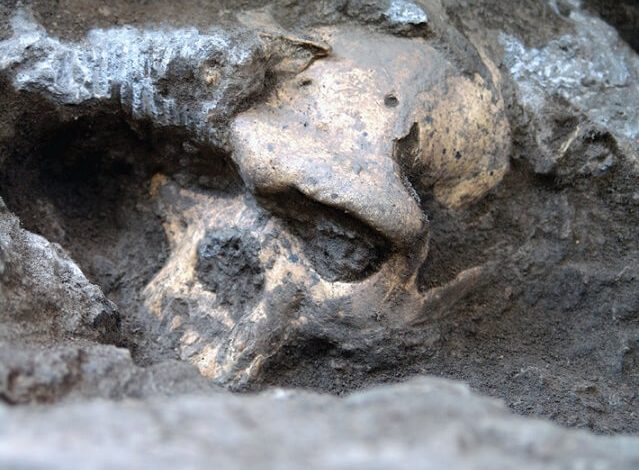
Skull 5 – A Million Years Old Human Skull Forced Scientists To Rethink Early Human Evolution
Researchers have traditionally used differences among fossilized remains of ancient humans to define separate species among the earliest members of our Homo genus — Homo erectus, Homo habilis, and Homo rudolfensis, for example.
A 1.8-million-year-old skull combines a small braincase with a long face and large teeth, which is unlike any other Homo fossils on record.
But an amazing new skull found in a republic of Georgia suggests that the specimens previously representing different species could come from a single, evolving lineage, according to a new report published in Science.
So-called “Skull 5” was dug up in Dmanisi, Georgia, between 2000 and 2005. It’s believed to date back roughly 1.8 million years and comes from the same time period and location as four other skulls found earlier at Dmanisi.
Skull 5 is unique not only because it is the most complete Homo skull ever found, but it also looks very different from the other skulls found at this site. It combines a small braincase — about one-third the size of modern humans — with a large face that has a massive jaw and big teeth.
“This is a strange combination of features that we didn’t know before in the early Homo,” Marcia S. Ponce de León, from the Anthropological Institute and Museum in Switzerland, said in a media conference.
The complete skull “skull 5” (far right), was found alongside the remains of four other human ancestors.
Researchers have found fragments of other skulls from this time period — from other places in Africa and also Dmanisi — but they are not complete and belong to adolescents.
Skull 5 provides the first evidence of how the face and jawbone of the full-grown early Homo were “oriented and positioned relative to the braincase,” according to the study.
Even though the Dmanisi fossils have different physical traits, researchers believe that all five skulls come from the same ancient population — a species that they say is most consistent with Homo erectus because of particular traits, like the shape of the braincase.
Skull 5 in National Museum
The strong variation seen within what’s believed to be a single species means that other Homo fossils from Africa could belong to that same, single lineage — they just have diverse appearances. “[The Dmanisi finds] look quite different from one another, so it’s tempting to publish them as different species,” Christoph Zollikofer from the Anthropological Institute and Museum said in a statement.”Yet we know that these individuals came from the same location and the same geological time, so they could, in principle, represent a single population of a single species.”
Researchers point out that the variations in brain size among the Dmanisi skulls are analogous to what we would see among five randomly chosen humans or chimpanzees today.
“It’s about the difference between a brain of 1.2 litres and 1.6 or 7 litres,” Zollikofer told reporters. The complete skull, “skull 5,” was found alongside the remains of four other human ancestors.
Archaeologists are still not sure if African fossils that pre-date the Dmanisi specimens — anything that is older than 1.8 to 1.9 million years and currently classified as Homo habilis or Homo rudolfensis — can be lumped into one species because the fossil remains are too scattered and not in good condition.
It’s also not clear what happened to Homo erectus after the date associated with the Dmanisi finds.
“We now have one global human species,” Zollikofer said. “What we can infer is that 1.8 million years ago there were another single global species.” He added: “We don’t know how Homo erectus connects to ourselves. That is the big question.”
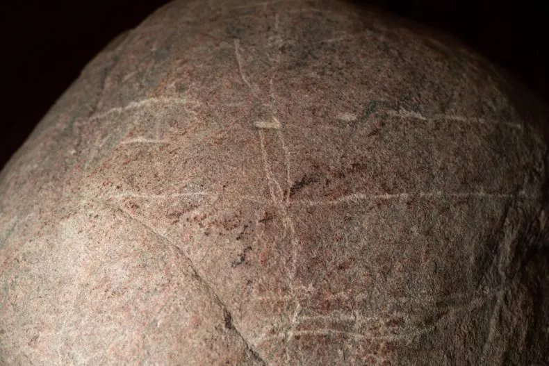
While feeding bison, a man discovers a rare 1,000-year-old rock carving by accident
An archaeologist has discovered rock carvings dating back over 1,000 years at Wanuskewin Heritage Park, Saskatchewan, Canada. What makes the discovery even more remarkable is that it happened completely by accident.
Wanuskewin’s chief archaeologist, Ernie Walker, made the discovery in the summer of 2020 while out feeding bison in a paddock located 800 meters west of the Wanuskewin building, it was announced on Friday.
As they were rolling around in the dirt wallowing, the bison had cleared a patch of ground where Walker spotted a boulder peeking through the dirt. Further inspecting the rock, the archaeologist noticed grooves that formed a definite pattern. Walker was able to determine that the boulder was actually a petroglyph.
Walker says that the boulder is a “Ribstone” resembling the bones of a bison and representing fertility, carved over a thousand years ago. He goes on to explain that he had searched the area previously but had missed the petroglyph.
Following this discovery, as the Ribstone was being excavated, Walker and his team turned up three more petroglyphs, as well as the tool that they believe was used to make the carvings.
“This is tremendously significant and very unusual,” Walker says. “Whoever did that, left it there or misplaced it, probably over a thousand years ago. I like to think it’s their business card. They left their business card here.”
The Wanuskewin Heritage Park team estimates that the petroglyphs date back anywhere between 300 and 1,800 years, when placed into the context of historic events this gives a probable age of 1,000 years old.
“It is extremely rare to find four carved boulders together, and even more rare to locate the carving tool used to make them.
A truly remarkable story, however, is the bison,” the team said in a press release. “Had they not been reintroduced to their traditional land— after being hunted nearly to extinction in the 1870s—this important scientific discovery would have remained hidden.”
Bison were reintroduced to Wanuskewin Heritage Park after an absence of over 150 years in 2019.
The reintroduction of the animal was part of a $40-million revitalization that included conservation efforts to repopulate bison numbers across North America.
A 1,000-year-old petroglyph was found in Wanuskewin.
“The discovery of these petroglyphs is a testament to just how sacred and important this land is,” CEO of Wanuskewin Heritage Park, Darlene Brander, said.
“The individual who made these petroglyphs was actually carving their legacy into the rock many years ago.”
The Wanuskewin Heritage Park, located on Opimihaw Creek, a tributary of the South Saskatchewan River, is currently applying for the status as a United Nations Educational Scientific and Cultural Organization Heritage site. Brander believes that this could be the deciding factor in that application.
Ernie Walker found the petroglyphs in the summer of 2020.
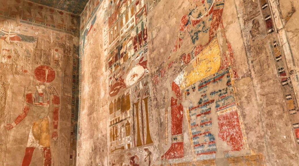
Female pharaoh’s temple reveals teamwork of Egypt’s ‘ancient masters’
The artists and sculptors of ancient Egypt may not be household names like Michelangelo, Raphael, or Caravaggio, but a new study of a female pharaoh’s temple suggests they had a lot in common with their Renaissance brethren. Instead of being solo artisans, sculptors worked in teams, with talented masters overseeing large crews of rookie chiselers and other assistants.
Two offering bearers at the Temple of Hatshepsut reveal sculptors of varying skill—the wig on the left was probably carved by an apprentice, the one on the right by a master.
Archaeologists say the study’s approach of scrutinizing the sculptors’ thousands of strokes is novel in Egyptology, which has long focused on interpreting written records. It reveals both the resources—and passion—ancient Egyptians poured into their art.
“The artists who created all this really flew below the Egyptological radar,” says Dimitri Laboury, an Egyptologist at the University of Liège who was not involved in the study. “But those artists were key figures in a society which invested so much in artistic production.”
For almost 2 centuries, researchers regarded tomb and temple decorations not as works of art in their own right, but as sources of information about ancient Egyptian religious beliefs. And artists in ancient Egypt didn’t sign their work, further pushing them into the background.
As a result, little is known about individual Egyptian artists and their methods, despite the key role paintings and reliefs played at a time when most people were illiterate.
Textual evidence hints at the presence of sculptors and painters but rarely the details of their work or who they were.
To better understand the work that went into decorating ancient temples, University of Warsaw archaeologist Anastasiia Stupko-Lubczynska and colleagues studied the temple of Hatshepsut, who ruled between 1478 B.C.E. and 1458 B.C.E. and was one of Egypt’s few female pharaohs. Her temple, which stretches 273 meters by 105 meters, was built almost 3500 years ago at Deir el-Bahari, near modern-day Luxor.
In a 70-square-meter room at the back known as the chapel of Hatshepsut, two 13-meter-long walls are carved with seemingly endless processions of men carrying offerings—sheaves of wheat, baskets of birds, and other goodies—to the seated Hatshepsut. The 200 figures occupy two-thirds of the room’s wall space.
Stupko-Lubczynska was there as part of a painstaking—and ongoing—effort by the University of Warsaw’s Polish-Egyptian expedition to clean and restore the temple’s damaged walls. Before conservationists cleaned the figures, Stupko-Lubczynska and a team of draftspeople spent hundreds of hours between 2006 and 2013 documenting the chapel walls by hand, copying the carvings on sheets of plastic film at a one-to-one scale. “We had to repeat the process done by the carvers, drawing all their lines, duplicating their steps,” she says.
Anastasiia Stupko-Lubczynska spent hundreds of hours tracing the hundreds of near-identical figures on the walls of Hatshepsut’s chapel.
In the process, the archaeologist identified tiny details in the soft limestone of the chapel, including clumsy chisel strokes and later corrections.
“Because we have so many figures with repetitive details, we can compare the details and workmanship,” Stupko-Lubczynska says. “If you look at enough of them, it’s easy to see when someone was doing it properly.”
Slowly, she and her colleagues began to see subtle variations in what had seemed like an army of cut-and-paste icons. And some figures were visibly worse—legs and torsos with sloppily chiseled edges, or multiple chisel blows to shape wig curls that only took two or three expert strokes elsewhere.
The analysis also showed the work was a team effort, done in phases by different artists, Stupko-Lubczynska reports today in Antiquity. “The wig can be awfully done, and in the same figure, the face is perfect,” she says.
“Maybe the master artisans came in at the end to finish the figure.” With no natural light in the cavernous, windowless hall, there must have also been assistants holding oil lamps crowding onto the scaffolds.
Laboury likens the effort to the busy workshops of Renaissance painters, where the master focused on the most challenging tasks while delegating backgrounds, supporting characters, and prep work to trainees.
Evidence that more skilled hands were correcting beginners’ mistakes suggests that even a pharaoh’s temple was seen as a place to school rookies. “You have more experienced hands next to less experienced hands,” Laboury says. “The master was training apprentices on the spot.”
“This study really adds to our understanding of craftsmanship and the way these ancient artists worked,” says Gabriele Pieke, an Egyptologist at the Reiss-Engelhorn Museum in Mannheim, Germany. She and others hope the look behind the scenes at Hatshepsut’s chapel will help raise the profile of the skilled artists responsible for so much of what we marvel at in ancient Egyptian tombs and temples.
After spending so much time tracing the work of long-gone artists, Stupko-Lubczynska says she began to feel a connection with—or at least empathy for—the long-suffering apprentices. “I like it more when somebody made a mistake or failed,” says. “You can feel that they were normal people like us, who could be tired or hungry or ill.”