1,500-Year-Old Industrial Agriculture Site Unearthed in Israel
Archaeologists in Israel have discovered a wine press, a rare gold coin and other artefacts linked to a settlement that stood in what’s now the Tel Aviv suburb of Ramat Ha-Sharon some 1,500 years ago.
The wine press dates to the Byzantine period.
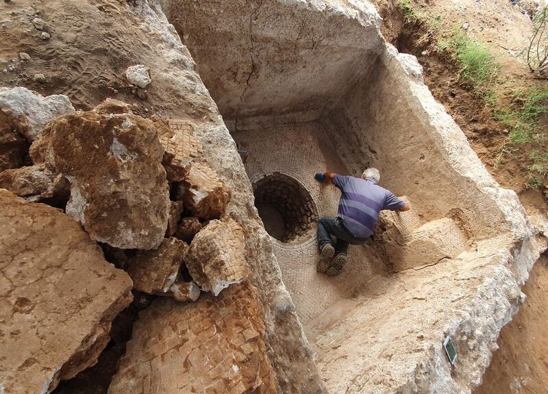
Paved with a mosaic floor, the large wine press is a key indicator that the site was home to agricultural-industrial activity during the Byzantine period, reports i24 News. Archaeologists from the Israel Antiquities Authority (IAA) also found the foundations of a large structure that may have served as a warehouse or farmstead.
“Inside the buildings and installations, we found many fragments of storage jars and cooking pots that were evidently used by labourers working in the fields here,” says excavation leader Yoel Arbel in a statement. “We also recovered stone mortars and millstones that were used to grind wheat and barley and probably also to crush herbs and medicinal plants.”
Arbel adds that most of the stone implements were made of basalt from the Golan Heights and Galilee, located 50 to 100 miles northeast of Ramat Ha-Sharon.
As Stuart Winer reports for the Times of Israel, the coin was minted in 638 or 639 C.E. under the authority of Byzantine emperor Heraclius. One side shows the emperor and his two sons.
The hill of Golgotha in Jerusalem, identified as the site of the crucifixion of Jesus in Christian gospels, appears on the reverse. Someone scratched an inscription, likely the name of the coin’s owner, onto its surface in Greek and possibly Arabic, according to Robert Kool, a coin expert with the IAA.
“The coin encapsulates fascinating data on the decline of Byzantine rule in the country and contemporary historical events, such as the Persian invasion and the emergence of Islam, and provides information on Christian and pagan symbolism and the local population who lived here,” says Kool in the statement.
The coin shows Emperor Heraclius and his sons.
Among the discoveries made at the site was a bronze chain that may have been used to suspend a chandelier—an artefact typically found in churches, writes Rossella Tercatin for the Jerusalem Post.
Other items dated to the early Islamic period, which began in the seventh century C.E. These included oil lamps, a glass workshop, and a warehouse with large vessels used to store grain and produce.
“In this period, people were not only working at the site but also living there, because we discovered the remains of houses and two large baking ovens,” says Arbel in the statement.
Archaeologists think the site remained in use until the 11th-century C.E.
The team conducted excavations in advance of the construction of a neighbourhood at the site.
“This is the first archaeological excavation ever conducted at the site, and only part of it was previously identified in an archaeological field survey,” says IAA Tel Aviv District archaeologist Diego Barkan in the statement. “The Israel Antiquities Authority views this as an excellent opportunity to integrate the ancient remains into plans for the future municipal park.”
Ramat Ha-Sharon’s mayor, Avi Gruber, says in the statement that local authorities are working with the new neighbourhood’s developers to integrate the archaeological site into the development.
“I want all our residents to enjoy learning about life here in antiquity and in the Middle Ages,” he adds.
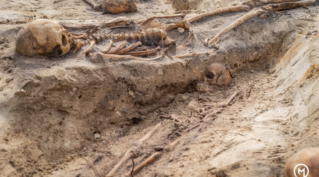
At the site of a new apartment building, a mass burial of 18th century plague victims was discovered.
An 18th-century cemetery containing the remains of plague victims has been uncovered during an apartment build in northern Poland. The grim discovery was made after builders stumbled upon human remains during work at the site in Mikołajki in the Warmian-Maurian Voivodeship.
The grim discovery was made after builders stumbled upon human remains during work at the site in Mikołajki in the Warmian-Maurian Voivodeship.
The find included two cemeteries, one dating between the 17th -19th century and a second from the 18th century when a plague swept through the Mazurian region.
The find included two cemeteries, one dating between the 17th -19th century and a second from the 18th century when a plague swept through the Mazurian region.
Archaeologist Agnieszka Jaremek vice-president of the Dajna Foundation said: “It is mentioned in sources that there was not enough space in the cemetery by the church and that’s why victims were buried by the road leading to Mrągowo.
“Everything points to the fact that we have uncovered that place.
“Many graves conceal whole families – both adults and children.”
The find included two cemeteries, one dating between the 17th -19th centuries and a second from the 18th century when a plague swept through the Mazurian region.
So far the remains of 100 people have been uncovered in 60 graves.
Known as the Great Northern War plague of 1700–1721, the epidemic swept across what is now northern Poland and other parts of Central Eastern Europe killing hundreds of thousands.
By the time the plague had faded out by December 1709 in the then city of Danzig, around half of its inhabitants had been killed.
After the plague, near to the graves of victims, further dead were buried and burials could have taken place there until the start of the 19th century.
In these graves, archaeologists uncovered items such as buttons.
Joanna Sobolewska, director of the Department for the Protection of Monuments in Olsztyn said that the uncovered human remains would be subjected to tests and anthropological analysis and after the end of tests, they would probably be buried in a communal grave. “The issue of the exact burial place is a question for the future”, she said.
The human remains will now be subjected to tests and anthropological analysis before being buried in a communal grave.
The site also concealed the remains of a Neolithic settlement and during works lasting several weeks, archaeologists from the Dajna Foundation in the name of Jerzy Okulicz-Kozaryn discovered remains from the Roman period.
Archaeologists think it is possible that the site was chosen for a settlement due to its proximity to a lake on one side and flat terrain on the other and according to estimates, the settlement could have occupied an area of 30-50 acres.
The Dajna Foundation’s Jaremek said: “Among the artefacts which we found are elements of ceramic plates as well as a blue glass bead.”
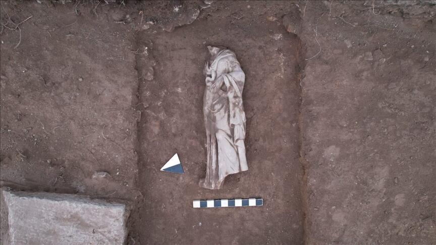
An ancient statue of the mythological goddess Hygieia – seen as the guardian or personification of health – has been discovered in an ancient city in western Turkey, according to a researcher.
“We unearthed a statue of Hygieia, known as the goddess of health and cleanliness, the daughter of Asclepius, the god of health in Greek and Roman mythology,” Gökhan Coşkun, who coordinates the dig in the ancient city of Aizanoi, told Anadolu Agency.
Noting that the marble statue’s head is missing – the fate of much ancient statuary – Coşkun, an archaeologist at Dumlupinar University in central Turkey, said: “Unfortunately, it hasn’t survived to the present day, but in its current form, we can see that this statue is about the size of a human.”
“During past digs in Aizanoi, finds related to Hygieia were also found,” he said. “This situation makes us think that there may have been some construction and buildings related to the health cult in Aizanoi during the Roman era.”
Located near the town of Cavdarhisar in the Kutahya province, the site is also home to one of the best-preserved temples in Anatolia dedicated to Zeus, the thunderbolt-wielding king of the Greek Olympians.
Groundbreaking ancient site
Seen as boasting a history rivaling Ephesus, another iconic ancient city in Turkey, Aizanoi was added to the UNESCO World Heritage Tentative List in 2012, with excavation efforts ongoing now for almost a decade.
Coşkun said that around 100 workers and 25 technical personnel are working on digs at the nearly 5,000-year-old site.
“We’re trying to reveal the columned galleries on the west and south wings of the agora (bazaar) and the shops right behind them,” he added.
Coşkun added that the statue of Hygieia – related to the modern word “hygiene” – was unearthed inside the columned gallery on the south wing of the agora.
Located 57 kilometres (35 miles) from the Kütahya city centre, the ancient site saw its golden age in the second and third centuries AD and became “the centre of the episcopacy in the Byzantine era,” according to the website of the Turkish Culture and Tourism Ministry.
Recent excavations around the Temple of Zeus indicate the existence of several levels of settlement in the city dating from as far back as 3000 BC. In 133 BC, it was captured by the Roman Empire.
In 1824, European travellers rediscovered the ancient site.
Between 1970 and 2011, the German Archeology Institute unearthed a theatre and a stadium, as well as two public baths, a gymnasium, five bridges, a trading building, necropolises and the sacred cave of Metre Steune – a cultist site thought to be used prior to the first century BC.
Since 2011, Turkish archaeologists have been carrying out the work at the ancient site. This year, the excavations were transferred to the Kutahya Museum Directorate.
Revealed: The ‘lost’ Anglo-Saxon monastery discovered next to Cookham church
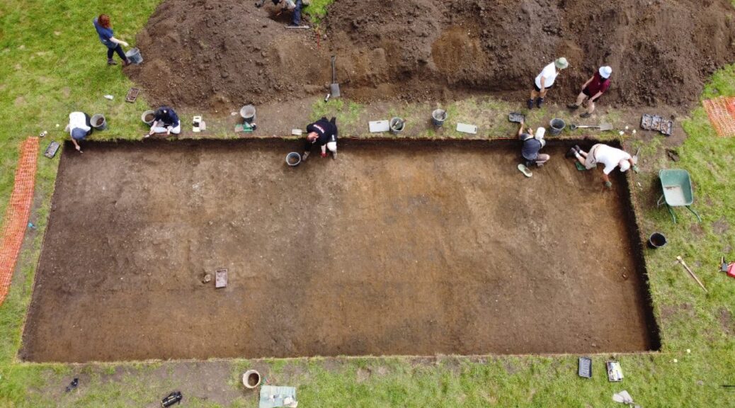
Archaeologists from the University of Reading have excavated a ‘lost” Anglo-Saxon monastery, in the present-day Berkshire village of Cookham, England. Despite being mentioned in a historical text, the location of the monastery had remained a mystery, with contemporary records placing it under the rule of a royal abbess: Queen Cynethryth, the widow of the powerful King Offa of Mercia.
Queen Cynethryth was the only Anglo Saxon queen to appear on her own on a coin.
Excavations were conducted by archaeologists from the University of Reading on the grounds of Holy Trinity, where they uncovered the remains of timber buildings that would have housed the inhabitants of the monastery, alongside artefacts providing insights into their lives.
Dr Gabor Thomas, the University of Reading archaeologist who is leading the excavation, said: “The lost monastery of Cookham has puzzled historians, with a number of theories put forward for its location.
Excavations of the lost monastery presided over by Queen Cynethryth.
We set out to solve this mystery once and for all. “The evidence we have found confirms beyond doubt that the Anglo-Saxon monastery was located on a gravel island beside the River Thames now occupied by the present parish church.
“Despite its documented royal associations, barely anything is known about what life was like at this monastery, or others on this stretch of the Thames, due to a lack of archaeological evidence.
The remains of the monastery led by the Anglo-Saxon ruler Queen Cynethryth were found near the banks of the Thames, in a field next to the parish church.
The items that have been uncovered will allow us to piece together a detailed impression of how the monks and nuns who lived here ate, worked and dressed. This will shed new light on how Anglo-Saxon monasteries were organised and what life was like in them.”
A network of monasteries was established on sites along the route of the Thames to take advantage of what was one of the most important trading arteries in Anglo-Saxon England, enabling them to develop into wealthy economic centres.
The stretch of the Thames in which Cookham falls formed a contested boundary between the kingdoms of Mercia and Wessex, so the monastery here had particular strategic and political importance. In spite of this historical background, the exact location of the monastery has been long debated.
Wealth of evidence
The excavation, in August, sought to answer this question by investigating open spaces straddling the churchyard of Holy Trinity Church, which still stands today.
The team have discovered a wealth of evidence including food remains pottery vessels used for cooking and eating, and items of personal dress including a delicate bronze bracelet and a dress pin, probably worn by female members of the community.
Clear evidence has emerged for the layout of the monastery which was organised into a series of functional zones demarcated by ditched boundaries.
One of these zones appears to have been used for housing and another for industrial activity indicated by a cluster of hearths probably used for metalworking.
‘Influence and status’
Dr Thomas added: “Cynethryth is a fascinating figure, a female leader who clearly had genuine status and influence in her lifetime. Not only were coins minted with her image, but it is known that when the powerful European leader Charlemagne wrote to his English counterparts, he wrote jointly to both King Offa and Queen Cynethryth, giving both equal status.
“We are thrilled to find physical evidence of the monastery she presided over, which is also very likely to be her final resting place.”
Cynethryth joined a religious order and became the royal abbess of the monastery after the death of her husband, King Offa, in AD 796. Before his death, he had ruled Mercia, one of the main Anglo Saxon kingdoms in Britain, which spanned the English Midlands.
King Offa is considered by many historians to have been the most powerful Anglo-Saxon king before Alfred the Great. He is known for ordering the creation of the earth barrier on the border between England and Wales, known as Offa’s Dyke, which can still be seen today.
Cynethryth is the only Anglo-Saxon queen known to be depicted on a coin – a rarity anywhere in Western Europe during the period. She died sometime after AD 798.
South Africa’s Bandit Slaves And The Rock Art Of Resistance
Not all South African rock art is ancient; some dates back to the colonial period – and was created by runaway slaves. It tells a remarkable story.
With the founding of the Cape Colony in 1652, European colonists were forbidden from enslaving the indigenous Khoe, San and African farmers. They had to look elsewhere for a labour force. And so slaves, captured and sold as property, were unwilling migrants to the Cape, transported – at great expense – from European colonies like Madagascar, Mauritius, Mozambique, the East Indies (now Indonesia), India and Sri Lanka.
Far cheaper was the illegal trade in indigenous slaves that grew in the borderlands of the colony. Khoe-San people were forced into servitude as colonists took both land and livestock. Together with immigrant slaves, they were the labour force for the colonial project.
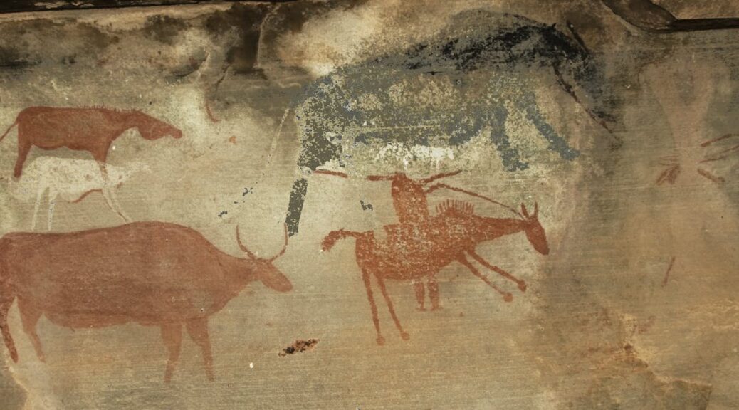
Louis van Mauritius (a) led a rebellion of 300 enslaved people in 1808 and ‘Portrait of Júli, a Faithful [Khoe-San]’ (b) by William Burchell, 1822.
Desertion was their most common form of rebellion. Runaway slaves escaped into the borderlands and mounted stiff resistance to the colonial advance from the 1700s until the mid-1800s. In most cases, the fugitives joined forces with groups of skelmbasters (mixed outlaws), who themselves were descended from San-, Khoe- and isiNtu-speaking Africans (hunter-gatherers, herders and farmers).
Thus, we find recorded examples of mixed bandit groups hiding out in mountain rock shelters, within striking distance of colonial farms. Using guerrilla-style warfare they raided livestock and guns. In their refuge, they made rock art, images within their own belief systems that relate to escape and retaliation.
These sites can be reliably dated because they include rock art images of horses and guns. In our most recent study of rock art in the Eastern Cape province of South Africa, we see that this art also provides us with the raiders’ perspective. Our fieldwork enables us to view something of the slave and indigenous resistance from outside the texts of the colonial record.
The paintings
These mountainous regions house many rock shelters with paintings of the traditional corpus of ‘San rock art’ (antelope and dances) that have become world-famous. But owing to almost 2,000 years of contact with incoming African herders and farmers, the hunter-gatherer art changed in appearance, if not in the essence of its meaning. The ‘disconnect’ was most stark, however, during colonisation. The artists’ societies were deeply affected, disrupted and decimated. Where any art continued it was that of the mixed outlaws, often referred to simply as ‘Bushmen’ but who was actually a composite of many cultural backgrounds.
In the colonial borderlands, paintings with (a) horses and guns and (b) ostriches and baboons.
The paintings themselves are also mixed – some brush-painted, some finger-painted – but are united by subject matter pertaining to spiritual beliefs concerning escape and protective power. Certain motifs, including baboons and ostriches, continued to be used, but now appearing alongside motifs such as horses and guns. This suggests some continuity in the recognition of these animals, mystical or otherwise, as subject matter pertinent to people’s changed circumstances.
Despite these changes, bandit groups, however mixed they were, held onto, and even highlighted, some specific traditional beliefs.
Ritual specialists
The location of one band of mixed outlaws, in the Mankazana River Valley in today’s Eastern Cape, comes from the record of the 1820 settler, poet and abolitionist Thomas Pringle. During our fieldwork in this area we found rock paintings of horses, riders with guns and cattle raids that can be reliably dated to approximately when Pringle was writing.
That diverse groups of bandits painted depictions of cattle raids suggests that raiding was a fundamental concern for these groups. If we have learnt anything from the last five decades of southern African rock art research, it is that images are not the mere depictions of what the artists saw around them. Rather, they are of what ritual specialists see while travelling through the spirit world.
In the case of bandit groups, the ritual specialist often performed the role of war-doctor, who supplied traditional medicines to ensure protection in dangerous situations, including cattle raids and the flight from servitude.
Finger-painted and fine-line horses attest to the mixed nature of bandit groups, note the baboons beneath the black horse.
It is telling that these images also include motifs relating to protection during raids as can be seen in the appearance of certain animals, especially baboons and ostriches.
Baboons are associated with protection across Khoe-San and African farmer society. The |Xam San people of the 1800s claimed that the baboon chewed a stick of so-/oa, a root medicine which would alert the user (animal or human) to approaching danger and keep it safe. Among the Xhosa there is a cognate belief in uMabophe – arguably the same root medicine. Like so-/oa, uMabophe was supplied by ritual specialists to those who wished to exert supernatural influence over projectile weapons, including turning ‘bullets to water’.
Protective animals
Many of these images are painted with a fine-line, unshaded technique. But there are also images that are finger-painted in black or bright orange pigment, which have a distinctly Khoe-speaker inflection. In technique they strongly resemble the art of the Korana raiders, to the north of the colony, who were known to take in runaway slaves.
Further into the hinterland, as if to mark the fighting retreat of bandit groups as the colonial frontier expanded, we discovered rock shelters in the Stormberg and Zuurberg that exhibit yet more features of an indigenous resistance idiom. In one are images of people with horses and guns, as well as baboons and ostriches.
The ostrich was recognised by Khoe-San groups as particularly adept at escaping danger. It could outrun most predators and leap over hunters’ nets. Khoe-San would, and still do, tie the tendons from ostrich legs to their own legs to combat fatigue. Ostrich eggshell was recognised as a medicine that could be ground and consumed as a fortifying tonic. In the art of bandits, images of ritual specialists transforming into ostriches or baboons attest to them drawing on the powers of protective animals to ensure their own escape from former captors or following stock raids.
The bandit’s view
Although never officially recognised as slaves, the Khoe-San were uprooted from their land and lifeways by European settlers and forced into bondage. This brought them into contact with immigrant slaves, alongside whom they often escaped. In defiance they raided their former captors and other settlers and in rocky hideouts they painted their concerns.
The rock art of bandit groups is bound up with beliefs in the ability to call upon the protection of the supernatural. Baboons and ostriches, painted with images of livestock and people on horseback with firearms, were heralded for their associated powers pertaining to escape and protection while raiding. For these runaway slaves, rock art was one of several crucial ritual observances performed to prevent the likelihood of ever returning to a life of oppression.
The insect, which is 49 million years old, appears to have been smashed just a few days ago
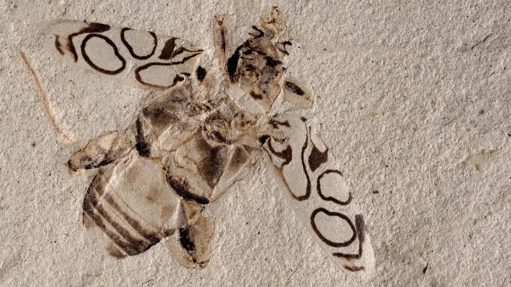
A beetle that lived about 49 million years ago is so well-preserved that the insect looks like it could spread its strikingly patterned wing coverings and fly away. That is if it weren’t squashed and fossilized.
Though originally identified as a type of long-horned beetle, Pulchritudo attenboroughi belongs to the frog-legged beetle group.
Wing cases, or elytra, are one of the sturdiest parts of a beetle’s exoskeleton, but even so, this level of colour contrast and clarity in a fossil is exceptionally rare, scientists recently reported.
The beautiful design on the ancient beetle’s elytra prompted researchers to name it Pulchritudo attenboroughi, or Attenborough’s Beauty, after famed naturalist and television host Sir David Attenborough. They wrote in a new study that the pattern is “the most perfectly preserved pigment-based colouration known in fossil beetles.”
When the researchers described the beetle beauty, it was already in the collection of the Denver Museum of Nature and Science (DMNS) in Colorado, where it had been on display since it was identified in 1995.
Palaeontologists found the fossil that year in the Green River Formation; once a group of lakes, this rich fossil site spans Colorado, Wyoming and Utah, and dates to the Eocene epoch (55.8 million to 33.9 million years ago).
Scientists initially classified the fossil as a long-horned beetle in the Cerambycidae genus. But while its body shape resembled those of long-horned beetles, its hind limbs were unusually short and beefy, which led the museum’s senior curator of entomology — Frank-Thorsten Krell, lead author of the new study — to question if the beetle might belong to a different group.
In the study, the authors described the beetle as a new genus in a subfamily known for its robust and powerful hind legs: frog-legged leaf beetles.
The fossilized insect, a female, is only the second example of a frog-legged leaf beetle to be found in North America, Krell told Live Science in an email (no modern beetles in this group live in North America today, according to the study).
On P. attenboroughi’s back, dark and symmetrical circular patterns stand out in sharp contrast against a light background. This suggests that bold patterns were present in beetles at least 50 million years ago, the researchers reported.
Digital reconstruction of Pulchritudo attenboroughi.
For a beetle to fossilize as well as this one did, “you need a very fine-grained sediment,” Krell said. Silt or clay at the bottom of a lake is the best substrate for fossilizing insects, and the beetle must sink quickly into the silty lake bottom before its body disintegrates. “And then it should not rot, so an oxygen-poor environment on the lake floor is helpful,” he said.
However, questions still remain about how sediments in the lake bottom preserved the beetle’s high-contrast colours so vividly, Krell added.
Visitors to the DMNS can admire P. attenboroughi for themselves, as the renamed fossil is back on display in the museum’s “Prehistoric Journey” exhibit, representatives said in a statement.
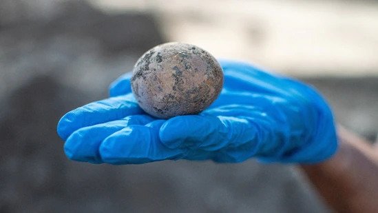
Preserved in poop: 1,000-year-old chicken egg found in Israel
It’s been said that the elegant egg is the perfect food, and that just might be true as eggs have been a staple of human diets for millions of years before chickens were domesticated for both eggs and meat some 8,000 years ago.
Israel Antiquities Authority discovered a fully intact 1,000-year-old chicken egg
In a remarkably rare discovery involving one of these ovoid essentials, scientists in Israel have cracked the archaeological case on a 1,000-year-old petrified egg that remained intact for centuries without breaking. This is an extraordinary event in that only a handful of ancient chicken eggs have ever been located undamaged.
During a recent excavation at an ancient Islamic cesspit dating back roughly 1,000 years ago, Israel Antiquities Authority archaeologists in Yavne unearthed a single unbroken chicken’s egg.
This expansive dig site, directed by Dr. Elie Haddad, Liat Nadav-Ziv, and Dr. Jon Seligman, had been the location of a diverse industrial settlement dating from the Byzantine period.
Intact chicken egg dating from roughly 1,000 years ago was revealed during archaeological excavations in Israel
“Eggshell fragments are known from earlier periods, for example in the City of David and at Caesarea and Apollonia, but due to the eggs’ fragile shells, hardly any whole chicken eggs have been preserved.
Even at the global level, this is an extremely rare find,” says Dr. Lee Perry Gal of the Israel Antiquities Authority in an official press statement provided to SYFY WIRE. “In archaeological digs, we occasionally find ancient ostrich eggs, whose thicker shells preserve them intact.”
Domesticated poultry farming first emerged in Israel 2,300 years ago, during the Hellenistic and Early Roman periods.
“Even today, eggs rarely survive for long in supermarket cartons. It’s amazing to think this is a 1,000-year-old find!” notes Israel Antiquities Authority archaeologist Alla Nagorsky in the same press release.
“The egg’s unique preservation is evidently due to the conditions in which it lay for centuries, nestled in a cesspit containing soft human waste that preserved it.”
Unfortunately, even with careful handling, researchers found that the shell of the egg had been slightly cracked. Back in the Israel Antiquities Authority’s organics lab, conservationist Ilan Naor was able to restore the egg for further study.
“Families needed a ready protein substitute that does not require cooling and preservation, and they found it in eggs and chicken meat,” adds Dr. Gal in the statement.
“Unfortunately, the egg had a small crack in the bottom so most of the contents had leaked out of it. Only some of the yolk remained, which was preserved for future DNA analysis.”
When German archaeologist Klaus Schmidt first began excavating on a Turkish mountaintop 25 years ago, he has convinced the buildings he uncovered were unusual, even unique.
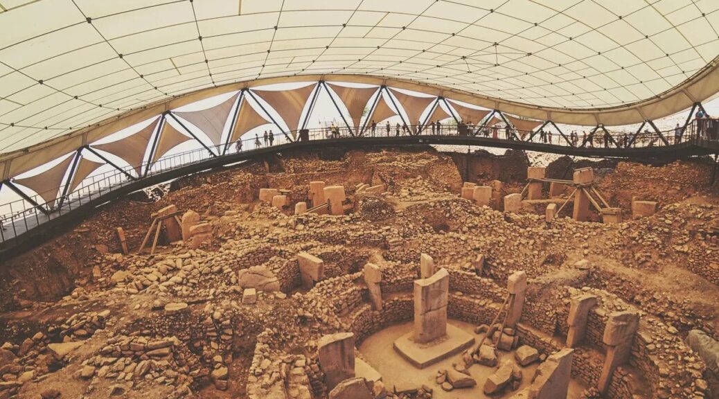
Atop a limestone plateau near Urfa called Gobekli Tepe, Turkish for “Belly Hill”, Schmidt discovered more than 20 circular stone enclosures. The largest was 20m across, a circle of stone with two elaborately carved pillars 5.5m tall at its centre. The carved stone pillars – eerie, stylised human figures with folded hands and fox-pelt belts – weighed up to 10 tons. Carving and erecting them must have been a tremendous technical challenge for people who hadn’t yet domesticated animals or invented pottery, let alone metal tools. The structures were 11,000 years old, or more, making them humanity’s oldest known monumental structures, built not for shelter but for some other purpose.
The structures were 11,000 years old, or more, making them humanity’s oldest known monumental structures
After a decade of work, Schmidt reached a remarkable conclusion. When I visited his dig house in Urfa’s old town in 2007, Schmidt – then working for the German Archaeological Institute – told me Gobekli Tepe could help rewrite the story of civilisation by explaining the reason humans started farming and began living in permanent settlements. The stone tools and other evidence Schmidt and his team found at the site showed that the circular enclosures had been built by hunter-gatherers, living off the land the way humans had since before the last Ice Age. Tens of thousands of animal bones that were uncovered were from wild species, and there was no evidence of domesticated grains or other plants.
Schmidt thought these hunter-gatherers had come together 11,500 years ago to carve Gobekli Tepe’s T-shaped pillars with stone tools, using the limestone bedrock of the hill beneath their feet as a quarry.
Situated in modern-day Turkey, Gobekli Tepe is one of the most important archaeological sites in the world
Carving and moving the pillars would have been a tremendous task, but perhaps not as difficult as it seems at first glance. The pillars are carved from the natural limestone layers of the hill’s bedrock. Limestone is soft enough to work with the flint or even wood tools available at the time, given practice and patience. And because the hill’s limestone formations were horizontal layers between 0.6m and 1.5m thick, archaeologists working at the site believe ancient builders just had to cut away the excess from the sides, rather than from underneath as well. Once a pillar was carved out, they then shifted it a few hundred metres across the hilltop, using rope, log beams and ample manpower.
Schmidt thought that small, nomadic bands from across the region were motivated by their beliefs to join forces on the hilltop for periodic building projects, hold great feasts and then scatter again. The site, Schmidt argued, was a ritual centre, perhaps some sort of burial or death cult complex, rather than a settlement.
That was a big claim. Archaeologists had long thought complex ritual and organised religion were luxuries that societies developed only once they began domesticating crops and animals, a transition known as the Neolithic. Once they had a food surplus, the thinking went, they could devote their extra resources to rituals and monuments.
Gobekli Tepe, Schmidt told me, turned that timeline upside down. The stone tools at the site, backed up by radiocarbon dates, placed it firmly in the pre-Neolithic era. More than 25 years after the first excavations there, there is still no evidence for domesticated plants or animals. And Schmidt didn’t think anyone lived at the site full-time. He called it a “cathedral on a hill”.
More than 25 years after the first excavations there, there is still no evidence for domesticated plants or animals.
If that was true, it showed that complex ritual and social organisation actually came before settlement and agriculture. Over the course of 1,000 years, the demands of gathering nomadic bands together in one place to carve and move huge T-pillars and build the circular enclosures prompted people to take the next step: to regularly host large gatherings, people needed to make food supplies more predictable and dependable by domesticating plants and animals. Rituals and religion, it seemed, launched the Neolithic Revolution.
The next day, I drove with Schmidt to the hilltop before dawn. I wondered, mystified and awestruck, among the pillars as Schmidt, his head wrapped in a white cloth to protect it from the blazing sun, oversaw a small team of German archaeologists and workers from the small village down the road.
Gobekli Tepe’s circular structures have changed the way archaeologists look at the beginnings of civilisation
Schmidt had just published his first reports on Gobekli Tepe the year before, setting the small world of Neolithic archaeology experts abuzz. But the site still had a sleepy, forgotten feel, with excavation areas covered by makeshift corrugated steel roofs and potholed dirt roads winding up to the mountaintop dig site from the valley below.
Schmidt’s take on the site’s striking T-pillars and large, round “special buildings” captivated colleagues and journalists when they were first published in the mid-2000s. Breathless media reports called the site the birthplace of religion; the German magazine Der Spiegel compared the fertile grasslands around the site to the Garden of Eden.
Soon, people from around the world were flocking to see Gobekli Tepe for themselves. Within a decade, the hilltop was totally transformed. Until the civil war in nearby Syria disrupted tourism in the region in 2012, work on the site often slowed to a crawl as busloads of curious tourists crowded around open excavation trenches to see what some were calling the world’s first temple and made it impossible to manoeuvre wheelbarrows on the narrow paths.
Over the past five years, the mountaintop on the outskirts of Urfa has been reshaped once again. Today, roads and car parks and a visitor’s centre can accommodate curious travellers from around the world. In 2017, corrugated steel sheds were replaced by a state-of-the-art, swooping fabric-and-steel shelter covering the central monumental buildings. swooping fabric-and-steel shelter covering the central monumental buildings. The Şanlıurfa Archaeology and Mosaic Museum, , built-in 2015 in central Urfa, is one of Turkey’s largest museums; it features a full-scale replica of the site’s largest enclosure and its imposing T-pillars, allowing visitors to get a feel for the monumental pillars and examine their carvings up close.
In 2018, Gobekli Tepe was added to the Unesco World Heritage register, and Turkish tourism officials declared 2019 the “Year of Gobekli Tepe”, making the ancient site the face of its global promotion campaign. “I still remember the site as a remote place on a mountaintop,” said Jens Notroff, a German Archaeological Institute archaeologist who began working at the site as a student in the mid-2000s. “It’s changed completely.”
Gobekli Tepe was constructed more than 11,000 years ago, right on the cusp between a world of hunter-gatherers and a world of farmers
Schmidt, who died in 2014, didn’t live to see the site’s transformation from dusty mountaintop dig to major tourist attraction. But his discoveries there spurred global interest in the Neolithic transition – and in the last few years, new discoveries at Gobekli Tepe and closer looks at the results of earlier excavations are upending Schmidt’s initial interpretations of the site itself.
Work on foundations needed to support the site’s swooping fabric canopy required archaeologists to dig deeper that Schmidt ever had. Under the direction of Schmidt’s successor, Lee Clare, a German Archaeological Institute team dug several “keyhole” trenches down to the site’s bedrock, several metres below the floors of the large buildings. “We had a unique chance,” Clare said, “to go look in the lowest layers and deposits of the site.”
New discoveries at Gobekli Tepe and closer looks at the results of earlier excavations are upending Schmidt’s initial interpretations of the site.
What Clare and his colleagues found may rewrite prehistory yet again. The digs revealed evidence of houses and year-round settlement, suggesting that Gobekli Tepe wasn’t an isolated temple visited on special occasions but a rather a thriving village with large special buildings at its centre.
The team also identified a large cistern and channels for collecting rainwater, key to supporting a settlement on the dry mountaintop, and thousands of grinding tools for processing grain for cooking porridge and brewing beer. “Gobekli Tepe is still a unique, special site, but the new insights fit better with what we know from other sites,” Clare said. “It was a fully-fledged settlement with permanent occupation. It’s changed our whole understanding of the site.”
Meanwhile, Turkish archaeologists working in the rugged countryside around Urfa have identified at least a dozen other hill-top sites with similar – if smaller – T-pillars, dating from around the same time period. “It’s not a unique temple,” said Austrian Archaeological Institute researcher Barbara Horejs, an expert on the Neolithic who was not part of the recent research efforts. “That makes the story much more interesting and exciting.” Turkish Culture and Tourism Minister Mehmet Nuri Ersoy went as far as saying that this area could be referred to as the “pyramids of south-east Turkey“.
New discoveries made over the last few years may rewrite prehistory yet again
Rather than a centuries-long building project inspiring the transition to farming, Clare and others now think Gobekli Tepe was an attempt by hunter-gatherers clinging to their vanishing lifestyle as the world changed around them. Evidence from the surrounding region shows people at other sites were experimenting with domesticated animals and plants – a trend the people of “Belly Hill” might have been resisting.
Clare argues the site’s stone carvings are an important clue. Elaborate carvings of foxes, leopards, serpents and vultures covering Gobekli Tepe’s pillars and walls “aren’t animals you see every day,” he said. “They’re more than just pictures, they’re narratives, which are very important in keeping groups together and creating a shared identity.”
When I first wandered across the site more than 15 years ago, I remember a feeling of great distance. Gobekli Tepe was built 6,000 years before Stonehenge, and the exact meaning of its carvings – like the world the people there once inhabited – is impossible to fathom.
That, of course, is part of the Gobekli Tepe’s tremendous magnetism. As thousands of visitors marvel at a place most people had never heard of a decade ago, researchers will continue trying to understand why it was built in the first place. And each new discovery promises to change what we now know about the site and the story of human civilisation.
“The new work isn’t destroying Klaus Schmidt’s thesis; it stands on his shoulders,” said Horejs. “There’s been a huge gain of knowledge, in my view. The interpretation is changing, but that’s what science is about.”