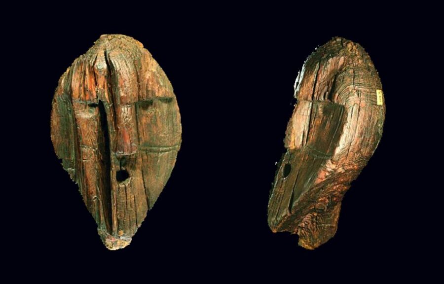
All posts by Archaeology World Team

Chinese Skeletons Found in Ancient Peruvian Pyramid

Chinese Skeletons Found in Ancient Peruvian Pyramid

Archaeologists exploring Peru’s pre-Colombian past recently unearthed a glimpse of a less prominent chapter in the Andean country’s history – the remains of 16 Chinese labourers from around the turn of the last century.

The bodies, thought to be those of indentured workers brought to Peru to replace slave labour, were found buried at the top of an adobe pyramid first used by the ancient Ichma people, Roxana Gomez, the lead archaeologist of the site, said in a statement.

Peru was one of the biggest destinations for Chinese labour in Latin America in the 20th century, a market that thrived after slavery was abolished in the country in 1854.

Chinese laborers in Peru circa 1900

The Chinese found at the Bellavista pyramid in Lima were buried in the late 1800s and early 1900s and had likely picked cotton at a nearby plantation in “very difficult” conditions, said Gomez.

In a possible sign of how the Chinese gradually emerged from dire poverty in Peru, the first 11 bodies were shrouded in cloth and placed in the ground, while the last five wore blue-green jackets and were buried in wooden coffins, Gomez said.

“In one Chinese coffin, an opium pipe and a small ceramic vessel were included in the funerary ensemble,” said Gomez.

Chinese labourers in the 20th century were generally not allowed to be buried at Lima’s Catholic cemeteries, forcing them to improvise burial sites, according to Peru’s Culture Ministry.

The remains of Chinese labourers were previously found in Lima at other adobe pyramids known as “huacas.” Built by the indigenous societies that once ruled much of Peru’s Pacific coast, huacas were used as administrative and religious centres where members of the elite were often buried with gold objects, ceramics or human sacrifices.

Gomez said the huacas had a sacred association that might have made them attractive places for burial by Chinese labourers.

The Bellavista Huaca was occupied by Ichma starting in about 1000 A.D. and was later annexed by the Incan empire until the arrival of Spanish conquerors who deemed huacas blasphemous.

Italian immigrants later kept vineyards at the base of the site, Gomez added.

“The best way to understand our history is as a continuum of different cultures,” said Gomez.

Over 3000-year-old ancient bronze figurine of bull uncovered in southern Greece

Over 3000-year-old ancient bronze figurine of bull uncovered in southern Greece

Following heavy rain near the ancient site of Olympia, a bronze figurine of a bull estimated to be at least 2,500 years old was discovered in Greece. Burn marks on the statuette suggest it may have been one of the thousands of offerings to the Greek god Zeus.

Over 3000-year-old ancient bronze figurine of bull uncovered in southern Greece
The small bull statuette is believed to have been offered to the god Zeus during a sacrifice

The discovery of the small, intact item was made by archaeologists near a temple, Greece’s culture ministry said. An archaeologist spotted one of the bull’s horns sticking out of the mud after a downpour, it added.

The item was immediately transferred to a laboratory for examination. Initial testing has indicated that the bull idol, which was found last month, dates from the Geometric period – about 1050BC to 700BC – of Greek art, the culture ministry said in a statement on Friday.

Animals such as bulls are believed to have been worshipped because of their importance at the time

Animals such as bulls and horses are believed to have been worshipped over that period because of their importance for human survival.

Like other animal and human figurines, the bull discovered near the temple of Zeus was likely to have been offered by believers during a sacrifice, which would explain the burn marks and “sediments removed during its purification”, the ministry added.

The site of Olympia in Greece is the birthplace of the ancient Olympic Games.

Ship Found 20 Feet Below World Trade Center Site Traced to Colonial-Era Philadelphia

Ship Found 20 Feet Below World Trade Center Site Traced to Colonial-Era Philadelphia

Researchers long stumped by the mysterious history of an 18th-century ship uncovered at the World Trade Center have finally discovered its origins — thanks to tree rings, according to a new study.

Ship Found 20 Feet Below World Trade Center Site Traced to Colonial-Era Philadelphia
The ship was uncovered in 2010, while workers were excavating the World Trade Center site.

The massive wooden ship — the skeleton of which was unexpectedly discovered 25 feet below street level in the muddy excavation of the World Trade Center site in 2010 — has now been traced to Colonial-era Philadelphia, with a history linked to Independence Hall, according to a new report from scientists at Columbia University’s Lamont-Doherty Earth Observatory.

Scientists say the wood from the vessel was chopped in 1773 from a forest of white oak trees in Philadelphia, the same type of trees used to build Independence Hall, where the Constitution and Declaration of Independence were signed.

Columbia scientists were able to link the growth rings found in the old wood of the ship with a previously taken sample of wood from Independence Hall, researchers said.

Tree rings are like “barcodes” that create unique patterns, allowing for dating, said Neil Pederson, Columbia tree ring scientist and co-author of the study.

Archaeologists dismantle the remains of an 18th-century ship at the World Trade Center construction site.

While the majority of the boat was made from white oak, a sample from the keel of the ship was the key to narrowing down its history.

“The keel was actually made from hickory, which was only found in the Eastern United States or Eastern Asia, which meant we could really narrow down our search — East Asia wasn’t really a possibility,” Pederson said. “That discovery really put me in a good mood — and put us in a good geographic zone.”

The ship’s 32-foot hull was carefully dug out of the muck in July 2010, exhaustively documented, disassembled, and sent off for preservation at the Maryland Archaeological Conservation Laboratory. Some timber samples, however, were sent to Columbia for analysis.

Historians believe the vessel was likely a merchant ship, in the Dutch style of a Hudson River sloop. It likely traveled along the Atlantic, bringing wood and food down to the West Indies and returning with sugar, salt, molasses, and rum.

The ship suffered an infestation of Teredo worms while in the Caribbean, which likely ate away at its wood and led to its demise after about 20 to 30 years on the water. It’s believed that by 1797, the boat was buried in the landfill used to extend Manhattan’s shoreline westward.

Hundreds of artifacts were found in and around the boat, including ceramics, musket balls, a buckle, a British button, a coin, animal bones, dozens of shoes, and a human hair with a single louse on it.

The ship remains at the Maryland Archaeological Conservation Laboratory, and researchers say it’s possible it may eventually be reassembled.

Guatemalan family uncovers ancient Mayan murals on their kitchen walls during a home renovation

Guatemalan family uncovers ancient Mayan murals on their kitchen walls during a home renovation

Home renovations in a Guatemalan mountain village in 2003 unearthed “unparalleled” Maya murals, according to researchers. Now, reports broadcast network RT, a new analysis published in the journal Antiquity has revealed additional insights on the wall paintings, which date to the 17th or 18th century and blend Spanish colonial influences with local indigenous culture.

Lucas Asicona Ramirez, right, discovered the centuries-old paintings after he started chipping away at the plaster in the kitchen of his house.

Local historian and study co-author Lucas Asicona Ramírez found the murals while renovating his kitchen in Chajul, a rural town in Guatemala’s highlands, reported Mike McDonald for Reuters in 2012.

Several houses in Chajul, including Asicona’s, date to the colonial era (1524 to 1821); other locals have discovered similarly historic artworks behind the plaster in their homes.

The Ramirez home is located in the impoverished town of Chajul, Guatemala.
Researchers work to preserve the Maya wall paintings inside the Chajul home.

The majority of Guatemala’s colonial-era murals are found in houses of worship. Centered on Christian themes, these religious artworks were used by the Spanish to assert their dominance over the Maya people, writes Tom Fish for Express. In contrast, the Chajul wall paintings appear inside private homes—and, most tellingly, contain distinct flourishes of indigenous culture.

“We consider these murals to be very unique,” Ivonne Putzeys, an archaeologist at the University of Guatemala in San Carlos, told Reuters. “It’s a tangible heritage that represents [s] real scenes from history.”

In 2015, an international team of researchers started preserving and studying the murals in collaboration with a Maya community indigenous to Guatemala: the Ixil. This group formed the bulk of the roughly 200,000 people killed during the Guatemalan Civil War, which lasted from 1960 to 1996.

As the experts write in the paper, conducting interviews and consultations with the Ixil was essential to understanding the art’s cultural context.

Many of the friezes feature dancers and musicians. Jaroslaw Źrałka, an archaeologist at Jagiellonian University and first author of the new study, tells Ancient Origins’ Ed Whelan that dance played an important role in the Maya civilization, both recording and relaying history and cultural practices. The dance was so important to the Maya that Spanish missionaries used it as a conversion tool, says Źrałka.

Through interviews with the Chajul Ixil community, the researchers were able to identify specific murals as depictions of known dances from the colonial era.

A mural of ancient vessels adorns the wall next to the family’s stove.

One mural shows tall, bearded conquistadors playing drums as they encounter a dancer dressed in a traditional feathered costume. This scene may illustrate the Dance of the Conquest, which details Spain’s invasion and attempts to convert the Maya to Christianity.

Another mural may show the Dance of the Moors and the Christians. Introduced by the Spaniards, this performance tells the story of Spain’s seizure of lands occupied by Muslim kingdoms, according to Express.

The researchers note that the wall art may also feature dances now lost to history. Many were forgotten when the government prohibited the performance of indigenous dances in the 19th and 20th centuries.

Chemical analysis of the paintings revealed the use of natural clay pigments typical in Maya art, suggesting the murals were indeed created by indigenous artists, reports Ancient Origins. The artworks’ style hews closely to local traditions, showing few signs of foreign influences.

The researchers suggest that the houses in which the murals were found once belonged to key community members—perhaps members of what was known as the cofradías, or brotherhood.

These groups organized religious events connected to both Christian and pre-Hispanic Maya traditions. The houses featuring the friezes may have served as meeting places or venues for rituals and dances.

Per the paper, the murals’ blending of Maya and European imagery could mean that local culture, as revived by the cofradías, was making a defiant comeback as Spain’s influence and control over the region faded.

Over 40 ancient shipwrecks discovered in the Black Sea

Over 40 ancient shipwrecks discovered in the Black Sea

Marco Polo himself may have recognised this medieval trading ship. It’s one of the 40 or so shipwrecks newly discovered on the bed of the Black Sea north of Turkey. Some of these vessels sank when the Byzantine Empire was in its heyday 1000 years ago, and some during more recent Ottoman times.

Others sank in the 13th century when Marco Polo was plying his trade across the globe. Most other wrecks from these time periods have been found in much shallower waters, where they have been eaten away down to just their hulls.

But the new haul was preserved for centuries on the seabed thanks to low-oxygen conditions that prevent the decay of timber. As a result, the architecture of the upper deck appears in unprecedented detail, allowing historians to see how well the features match up to historical accounts.

New images show finely carved rudders, masts, tillers, and even ropes that are almost perfectly preserved.

They were rediscovered by submersibles scouring the seabed as part of a project to piece together how and when sea levels rose again in the Black Sea following the last ice age, which peaked 20,000 years ago.

Over 40 ancient shipwrecks discovered in the Black Sea

The Black Sea Maritime Archaeology Project has uncovered 41 wrecks this year so far, revealing them in all their glory thanks to a state-of-the-art imagery method called 3D photogrammetry.

“We took thousands of high-quality stills and video around the whole of each wreck,” explains Jon Adams at the University of Southampton, UK, and principal investigator on the project. “Software calculates the positions of millions of points in 3D space, generating accurate, detailed 3D images of each wreck.”

Well-preserved

Adams says that the medieval ships have never been seen in such a well-preserved state. “We’ve never seen them this complete,” he says. “Normally, it’s just bits of the lower hull, but here we have much upper-deck material.”

One of the medieval ships – found 1100 metres down – was probably an Italian trading craft from around the 1300s, of a type that Marco Polo would recognise. Although its iron-fastened hull planks have fallen to the seabed, it retains the stern platform with its rudders intact.

“The mast is also still standing, with the yardarms lying on the deck,” he says. “We can still see rigging and pots on board.”

It also has features of more ancient ship technology, such as “quarter rudders” on each flank at the ship’s rear for steering, rather than the single centre-line stern rudder that became the norm in around 1400 and beyond.

Other wrecks were also beautifully preserved. An Ottoman trading ship from a few centuries later retained many deck features, including masts. In addition, images show a beautifully carved tiller with coils of rope hanging from the timbers at the ship’s rear.

Because they all sank far out at sea, Adams believes that these were trading ships rather than ships sunk in battle. “They’re all a long way offshore, so they were probably overwhelmed by rough weather,” he says.

Munigua, a hidden Roman city in the Sevilla sierra, spain

Munigua, a hidden Roman city in the Sevilla sierra, spain

There is no shortage of Roman ruins in Spain. Some are in the middle of modern city centres, such as Mérida’s theatre and amphitheatre, in Extremadura. Or Itálica, which is reachable by bus from Seville. Others are out in the middle of nowhere, at the end of a track, in a random field. This was the case with Munigua, making it a reasonable option to explore in the middle of a pandemic.

Western Wall of the Sanctuary

The story of Munigua

For centuries it was taken for granted that the temple must have been an ancient castle, abandoned after some old war. Only recently, when the Roman inscriptions appeared, the scholars realized that they were dealing with a Roman temple.

But this temple is way too big for the size of the city. We do not know to which deity it was dedicated. Given its enormous size, it must have been a significant Iberian god or goddess. 

Munigua was founded in the III century BCE before Romans came. But let’s not lose hope: excavations have been going on for over 60 years, so sooner or later we will know!

The Romans took over the Iberian city because it was located close to very rich mines. But alas, an earthquake destroyed the town in the III century ADE, and it was never rebuilt.

Eastern slope of the site with private and public buildings

The mines had been worn out already, and the city was far away from everything. Some people stayed there to live, especially the Moorish. In Munigua, you can actually see the oldest Moorish tombs in Spain. But it was not an important city anymore. In the XII century, it was definitely abandoned.  

Since then, people simply have forgotten that once upon a time, there had been a whole city right in this spot. This is how you find Munigua today: in the middle of the same landscape that the Romans knew -wild, unique, still full of mysteries. 

The visit to Munigua

If you plan to go to Munigua, make sure that the weather conditions are right. If it is raining, it will not be opened. On the bright side, the entrance is free.

Bring your drinks and food -there are no shops there. Think of this visit as if you went for a hike to the mountains! Do not forget solar protection -it is Sevilla, so it will be most likely sunny – and comfortable shoes -after all, you are going to walk at least 6 km!

There are few cities in Spain like Munigua. You get to walk around its ancient streets and get inside the very well preserved buildings. The shovels of the archaeologists have dug out thermae, big houses, a forum, temples, some parts of the ancient city wall.

The funny thing about this one… it was never ended. Also, it went through the two necropoleis of the town, which was very strange for a Roman city: the dead people were always left outside. Same thing with the main temple, at the top of the hill: its architecture in terraces is very atypical in the Roman world. 

The whole city is built indeed on terraces, with stairs going in all directions, like big chaos, very unlike the civilized Roman order. We can only assume that the previous Iberian inhabitants never entirely left!

The Arctic Could Turn Green and Free of Ice Like it was 125,000 Years Ago

The Arctic Could Turn Green and Free of Ice Like it was 125,000 Years Ago

Researchers analyzed plant DNA more than 100,000 years old retrieved from lake sediment in the Arctic (the oldest DNA in lake sediment analyzed in a publication to date) and found evidence of a shrub native to northern Canadian ecosystems 250 miles (400 km) farther north than its current range.

As the Arctic warms much faster than everywhere else on the planet in response to climate change, the findings, published this week in the Proceedings of the National Academy of Sciences, may not only be a glimpse of the past but a snapshot of our potential future.

“We have this really rare view into a particularly warm period in the past that was arguably the most recent time that it was warmer than present in the Arctic. That makes it a really useful analogue for what we might expect in the future,” said Sarah Crump, who conducted the work as a Ph.D. student in geological sciences and then a postdoctoral researcher with the Institute of Arctic and Alpine Research (INSTAAR).

To gain this glimpse back in time, the researchers not only analyzed DNA samples, they first had to journey to a remote region of the Arctic by ATV and snowmobile to gather them and bring them back.

Dwarf birch is a key species of the low Arctic tundra, where slightly taller shrubs (reaching a person’s knees) can grow in an otherwise cold and inhospitable environment. But dwarf birch doesn’t currently survive past the southern part of Baffin Island in the Canadian Arctic. Yet researchers found DNA of this plant in the ancient lake sediment showing it used to grow much farther north.

“It’s a pretty significant difference from the distribution of tundra plants today,” said Crump, currently a postdoctoral fellow in the Paleogenomics Lab at the University of California Santa Cruz.

Tundra Plants

While there are many potential ecological effects of the dwarf birch creeping farther north, Crump and her colleagues examined the climate feedbacks related to these shrubs covering more of the Arctic. Many climate models don’t include these kinds of changes in vegetation, yet these taller shrubs can stick out above snow in the spring and fall, making the Earth’s surface dark green instead of white — causing it to absorb more heat from the sun.

“It’s a temperature feedback similar to sea ice loss,” said Crump. During the last interglacial period, between 116,000 and 125,000 years ago, these plants had thousands of years to adjust and move in response to warmer temperatures. With today’s rapid rate of warming, the vegetation is likely not keeping pace, but that doesn’t mean it won’t play an important role in impacting everything from thawing permafrost to melting glaciers and sea-level rise.

“As we think about how landscapes will equilibrate to current warming, it’s really important that we account for how these plant ranges are going to change,” said Crump.

As the Arctic could easily see an increase of 9 degrees Fahrenheit (5 degrees Celsius) above pre-industrial levels by 2100, the same temperature it was in the last interglacial period, these findings can help us better understand how our landscapes might change as the Arctic is on track to again reach these ancient temperatures by the end of the century.

Mud as a microscope

To get the ancient DNA they wanted, the researchers couldn’t look to the ocean or to the land — they had to look in a lake. Baffin Island is located on the northeastern side of Arctic Canada, kitty-corner to Greenland, in the territory of Nunavut and the lands of the Qikiqtaani Inuit. It’s the largest island in Canada and the fifth-largest island in the world, with a mountain range that runs along its northeastern edge. But these scientists were interested in a small lake, past the mountains and near the coast.

Above the Arctic Circle, the area around this lake is typical of a high Arctic tundra, with average annual temperatures below 15 °F (?9.5 °C). In this inhospitable climate, the soil is thin and not much of anything grows.

But DNA stored in the lake beds below tells a much different story. To reach this valuable resource, Crump and her fellow researchers carefully balanced on cheap inflatable boats in the summer — the only vessels light enough to carry with them — and watched out for polar bears from the lake ice in winter. They pierced the thick mud up to 30 feet (10 meters) below its surface with long, cylindrical pipes, hammering them deep into the sediment.

The goal of this precarious feat? To carefully withdraw a vertical history of ancient plant material to then travel back out with and take back to the lab. While some of the mud was analyzed at a state-of-the-art organic geochemistry lab in the Sustainability, Energy and Environment Community (SEEC) at CU Boulder, it also needed to reach a special lab dedicated to decoding ancient DNA, at Curtin University in Perth.

To share their secrets, these mud cores had to travel halfway across the world from the Arctic to Australia.

A local snapshot

Once in the lab, the scientists had to suit up like astronauts and examine the mud in an ultra-clean space to ensure that their own DNA didn’t contaminate that any of their hard-earned samples.

It was a race against the clock.

“Your best shot is getting fresh mud,” said Crump. “Once it’s out of the lake, the DNA is going to start to degrade.”

This is why older lake bed samples in cold storage don’t quite do the trick. While other researchers have also collected and analyzed much older DNA samples from permafrost in the Arctic (which acts as a natural freezer underground), lake sediments are kept cool, but not frozen. With fresher mud and more intact DNA, scientists can get a clearer and more detailed picture of the vegetation which once grew in that immediate area.

Reconstructing historic vegetation has most commonly been done using fossil pollen records, which preserve well in sediment. But pollen is prone to only showing the big picture, as it is easily blown about by the wind and doesn’t stay in one place. The new technique used by Crump and her colleagues allowed them to extract plant DNA directly from the sediment, sequence the DNA, and infer what plant species were living there at the time. Instead of a regional picture, sedimentary DNA analysis gives researchers a local snapshot of the plant species living there at the time. Now that they have shown it’s possible to extract DNA that’s over 100,000 years old, future possibilities abound.

“This tool is going to be really useful on these longer timescales,” said Crump. This research has also planted the seed to study more than just plants. In the DNA samples from their lake sediment, there are signals from a whole range of organisms that lived in and around the lake.

“We’re just starting to scratch the surface of what we’re able to see in these past ecosystems,” said Crump. “We can see the past presence of everything from microbes to mammals, and we can start to get much broader pictures of how past ecosystems looked and how they functioned.”

Researchers Map World War II Bomb Craters in Poland

Researchers Map World War II Bomb Craters in Poland

According to a Live Science report, Maria Fajer of the University of Silesia and her colleagues employed lidar technology to record some 6,000 bomb craters in the Koźle Basin, an area of forests and wetlands in southern Poland that was part of Germany during World War II.

Lidar scans revealed thousands of craters in Poland's Koźle Basin, remnants of intense Allied bombings during 1943 and 1944.
Lidar scans revealed thousands of craters in Poland’s Koźle Basin, remnants of intense Allied bombings during 1943 and 1944.

Researchers recently mapped and analyzed the deeply scarred landscape for the first time, counting around 6,000 bomb craters ranging from 16 to 49 feet (5 to 15 meters) in diameter. Some areas held as many as 30 craters in a single hectare (10,000 square meters).

Their investigation presents a grim picture of the damage sustained by the battle-torn terrain, known as the Koźle Basin. But it also offers a glimpse of how the craters have since become an important part of the basin’s natural landscape and ecosystems, the scientists reported in a new study.

The Koźle Basin covers an area of approximately 180 square miles (470 square kilometers). Within the basin, extending for about 60 square miles (150 square km), “there are clusters of remnants of the Allied air campaign conducted there in the second half of 1944,” said study author Maria Fajer, a geomorphology researcher with the Faculty of Earth Sciences at the University of Silesia in Katowice, Poland.

“These are variously preserved bomb craters, ranging from those that are very well visible in the field to traces of backfilled and reclaimed craters,” Fajer told Live Science in an email. 

Nazi Germany controlled the Koźle Basin during WWII and used the region for industrial fuel production. It was the biggest such site in the entire Third Reich, the scientists reported. Coal and water were easily accessible there, while dense forests and sheltering hills provided natural cover from air and ground attacks.

Because the basin’s topography trapped air masses, the Germans could add another layer of protection to their operation by producing thick anti-aircraft smoke screens.

Great Britain’s Royal Air Force began targeting the region for the bombing in February 1943, and in June 1944 Americans and British pilots prioritized the destruction of Nazi oil refineries, as well as fuel and chemical factories.

Wartime records describe Allied planes dropping a total of 39,137 bombs in the Koźle Basin. Most of these were delayed-action bombs that were “intended for the destruction of buildings, reinforced concrete, and metal structures, as well as land-cratering,” the scientists reported March 16 in the journal Antiquity.

Uncounted numbers of craters were scoured away during postwar construction and agriculture, and researchers decided to map the region before more evidence of this noteworthy wartime bombardment was lost forever, according to the study. 

Allied planes targeted Nazi industrial factories in the Koźle Basin with tens of thousands of bombs.

Scanning with lasers

The researchers deployed a remote sensing method called light detection and ranging, or lidar, which uses laser pulses to peer through vegetation and reveal features in the ground.

By examining the sizes, shapes, and distribution of thousands of craters, the researchers were able to piece together a picture of the types of bombs that were used; how many were dropped at the same time; and ground conditions at the time of impact.

Today, these craters “are relics that document important historical events, and that constitutes a link between the area and the battlefields of Europe and beyond,” the study authors wrote. In the 75 years that have passed since the war, these remnants of violent explosions have gradually become part of the forest habitat.

“They now represent places where many amphibian, reptile, insect, bird, and ungulate species reside, seek shelter, or breed. The craters also provide habitats for numerous plant species,” the study authors wrote.

“The many water bodies and marshes that formed in the bomb craters contribute to the diversification and enrichment of local ecosystems, where sandy soils dominate.” 

Many species of animals and plants now make their homes in and around the Koźle Basin craters.

Follow-up studies by the scientists will further explore the ecological role of craters in forest ecosystems and the threats posed by unexploded bombs, Fajer said.

In the decades since WWII, natural processes such as erosion have erased many of the craters, while industry, farming, and other human activities could wipe away still more. Mapping the bomb fields will therefore help to preserve a record of WWII devastation before it vanishes. 

The researchers also argue that locations marred by WWII devastation, such as the still-scarred Koźle Basin, should be conserved for future generations. These areas “should be covered by special heritage protection measures to help us remember the consequences of the bad decisions that led to the war,” Fajer said.