Revealed: Cambodia’s vast medieval cities hidden beneath the jungle

Revealed: Cambodia’s vast medieval cities hidden beneath the jungle

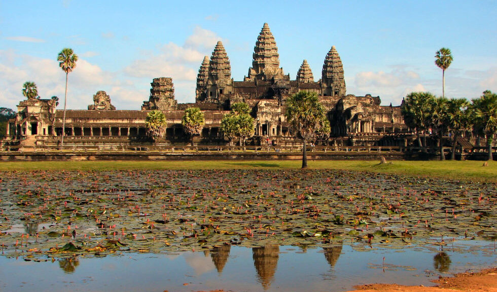
Archaeologists in Cambodia have found multiple, previously undocumented medieval cities not far from the ancient temple city of Angkor Wat, the Guardian can reveal, in groundbreaking discoveries that promise to upend key assumptions about south-east Asia’s history.

The Australian archaeologist Dr Damian Evans, whose findings will be published in the Journal of Archaeological Science, will announce that cutting-edge airborne laser scanning technology has revealed multiple cities between 900 and 1,400 years old beneath the tropical forest floor, some of which rival the size of Cambodia’s capital, Phnom Penh.

Invisible city

For centuries, the Angkor region’s wealth of artefacts drew looters, archaeologists. They focused their attention, both good and ill, on Angkor Wat and a few other nearby moated temple complexes. Based on those ruins, the first European explorers to encounter Angkor in the 19th century assumed Khmer urbanites lived in what were basically moated cities of a few thousand people. These European explorers thought Angkor Wat was something like a medieval walled city in Europe, which typically held fewer than 10,000 people. They explained all the moated complexes in the Angkor area by suggesting that maybe the royal family and their people were moving from one moated city to the next overtime. But as archaeologists learned more in the intervening century, something about those population numbers seemed off. Beyond the moated cities were vast canal systems and reservoirs hinting at something bigger.

The ruins of Preah Khan of Kompong Svay covered with forest. An urban network was revealed by the lidar imagery around this temple.

Unfortunately, most of Angkor had become a tangle of jungles and small farms by the 20th century. There was little evidence of medieval settlements beyond the moats’ precise edges. Even if explorers were willing to hack through the dense growth, there was little to find. In a Khmer city, only the temples were made from stone. Everything else was built from perishable materials like wood. All that remained of Angkor’s homes and other non-religious structures were the elevated clay mounds of their foundations, which had been designed to prevent flooding during Cambodia’s intense wet season. Most of the city’s dramatic waterworks for flood runoff and water storage had been reduced to pits and troughs in the Earth. It was practically impossible to identify a medieval Angkorian house deep within the jungle.

All that changed when airborne LiDAR (for “Light Imaging, Detection, And Ranging”) came into common use for mapping in the early 2000s. Archaeologists working in Cambodia immediately seized on it. By scattering light off the surface of the planet, LiDAR systems can produce maps with accuracy down to the centimetre even if the ground is covered in heavy vegetation. The system is ideal for a place like Angkor, where the city’s remains are cloaked in vegetation and characterized almost entirely by elevated or depressed plots of ground.

The LiDAR rig was a Leica ALS70 HP instrument, mounted in a pod attached to the right skid of a Eurocopter AS350 B2 helicopter along with a 60 megapixel Leica RCD30 camera.

With funding from the National Geographic Society and European Research council, archaeologist Damian Evans and his colleagues conducted broad LiDAR surveys of Angkor in 2012 and 2015. The team’s mapping rig consisted of a Leica ALS70 HP LiDAR instrument mounted in a pod attached to the right skid of a Eurocopter AS350 B2 helicopter alongside a 60 megapixel Leica RCD30 camera. It was as if an invisible city suddenly appeared where only overgrowth and farmland existed before. For the first time in centuries, people could discern Angkor’s original urban grid. And what they saw changed our understanding of global history.

Archaeological researcher Piphal Heng, who studies Cambodian settlement history, told Ars that the LiDAR maps peeled back the forest canopy to reveal meticulous grids of highways and low-density neighbourhoods of thousands of houses and pools of water. There was “a complex urban grid system that extended outside the walls of Angkor Thom and other large temple complexes such as Angkor Wat, Preah Khan, and Ta Prohm,” he said. With the new data, scientists had solid evidence that the city of Angkor sprawled over an area of at least 40 to 50 square km. It was home to almost a million people. The scattered, moated complexes like Angkor Wat and Angkor Thom were merely the most enduring features of what we now know was the biggest city on Earth during the 12th and 13th centuries.

This aerial photo shows what Angkor Wat looks like today, surrounded by vegetation and a few areas of modern farms and homes. None of the vast city grid from 800 years ago is visible.
In the LiDAR map, you can clearly see the central urban grid of Angkor extending from Angkor Thom (top left) and Angkor Wat (bottom left).
Here you can see the areas covered by the LiDAR surveys in 2012 and 2015.
A map of the greater Angkor area, showing the extent of the urban sprawl revealed by LiDAR.

From legend to reality

The city of Angkor has its origins in the ninth century during the reign of Jayavarman II. He unified large parts of Southeast Asia by establishing the Khmer Empire across regions we know today as Cambodia, Thailand, Vietnam, and Laos. Inscriptions on temple walls at Sadok Kok Thom in Thailand describe how he established a city called Hariharalaya, located near Siem Reap in the Angkor area. But the inscriptions also say that Jayavarman II declared himself a supreme ruler or “god-king” in a lavish Hindu ceremony held at his residence on Kulen Mountain in a city called Mahendraparvata. Accounts of the Kulen Mountain phase in Jayavarman’s life are so sparse and fantastical that debates have raged among scholars about whether he actually lived in Mahendraparvata at all.

To find out more, archaeologists targeted Kulen Mountain in their latest LiDAR survey. Evans published some of the first results from this 2015 survey in the Journal of Archaeological Science. Royal Academy of Cambodia archaeologist Kaseka Phon explained to Ars via e-mail that the LiDAR has uncovered an Angkor-like city grid at the abandoned city of Mahendraparvata on Kulen Mountain. Plus, the LiDAR “shows not only features of the construction, but also water features” that are clearly versions of Angkor’s incredible water management facilities. The new survey revealed massive stone quarries, now filled in, that produced the rock used to build some of the temples of Angkor. Kulen Mountain’s role in the birth of the Khmer Empire is no longer a legend—it’s an established historical fact.

This transformation of legend into fact has been a theme of the LiDAR surveys. Angkor’s huge population is described in temple inscriptions and reports written by Chinese travellers who visited the city during the 12th-century reign of King Suryavarman II, who built Angkor Wat. But historical sources are often exaggerated or incomplete. Plus, it was difficult for Western researchers to believe that the Khmer Empire’s great city was home to almost a million people, dwarfing European cities of the same era. Now, such facts are impossible to deny.

Angkor city planning

Angkor reached megacity proportions in the 12th century when Suryavarman II ordered the construction of Angkor Wat (which he dedicated to the Hindu god Vishnu). At that time, the urban sprawl in Angkor was not only enormous, but it was centrally planned with rigorous precision. Heng told Ars that “the shape of roads, walls, moats, mounds, and ponds were probably made based on urban templates commissioned by the Angkorian rulers” while residents of different neighbourhoods probably had different degrees of freedom to modify those plans. Heng continued:

At temples such as Angkor Wat and Ta Prohm, the grid usage was significantly varied. For example, based on our recent excavations, after the urban grid was laid out, there is little evidence of modification—if at all—in a series of habitation mounds inside Angkor Wat. While for Ta Prohm, its inhabitants seem to have more freedom in modifying parts of their gridded mounds.

To learn more about everyday life in Angkor Wat, University of Illinois Urbana-Champaign archaeologist Alison Carter has done excavation work on some of the residential mounds inside the enclosure. In 2015, she got funding from the National Geographic Society to excavate one of the residential mounds identified via LiDAR. Carter discovered what appears to be the remains of a brick stove, complete with ceramic vessels for cooking. Chemical analysis revealed remains of pomelo fruit rind, seeds from a relative of the ginger plant, and grains of rice. This is what archaeologists call “ground-truthing,” and it’s further confirmation that the mounds we see in LiDAR are actually from households rather than other structures.

The picture that’s emerging of Angkor is much like a modern low-density city with mixed-use residential and farm areas. As Evans put it to Ars, “in the densely inhabited downtown core there are no fields, but that nice, formally planned city centre gradually gives way to an extended agro-urban hinterland where neighbourhoods are intermingled with rice-growing areas, and there is no clear distinction between what is ‘urban’ or ‘rural’.” The city was a miracle of geoengineering with every acre transformed by human hands, whether for agriculture or architecture.

Perhaps Angkor’s greatest technological achievement was its sophisticated waterworks, including artificial canals and reservoirs. People strolling through the city 800 years ago would have passed through neighborhoods whose carefully arranged homes were built alongside rainfall ponds for families, as well as enormous canals for the city as a whole. Massive rectangular reservoirs held water all year around for agricultural use.

Each neighbourhood would have looked slightly different, though all relied on the same water infrastructure. The city had to survive the floods of the rainy season and slake the thirst of people and farms in the dry season. For centuries, it accomplished this incredible feat, which modern cities still struggle with. Suryavarman II ruled a city whose mythic proportions were enabled by the most sophisticated engineering techniques of his day.

Comparison of major temple complexes in the 12th to 13th centuries, all at the same scale. Later developments (right column) show more variable grids than earlier ones (left column), with areas within the moat divided neatly into ~100×100 m “city blocks.” 6a: Angkor Wat. 6b: Beng Mealea. 6c: Preah Khan of Kompong Svay. 6d: Preah Khan of Angkor. 6e: Ta Prohm. 6f: Banteay Chhmar.
“Mound fields” across Cambodia. Panels a,b are in the Phnom Kulen area. Panels c,d are immediately to the north of the main temple complex at Sambor Prei Kuk. Panels e,f are Immediately to the west of Banteay Srei temple at Angkor. Panels g,h: Near the exit of the East Baray reservoir at Angkor, new archaeological mapping (3g) based on the 2012 ALS data has added further detail to a ~10×10 grid of mounds (3h) and revealed a second mound field to the south of the exit. Panels 3a,c and e are conventional aerial imagery acquired in the 2015 campaign. Panel 3g is based on archaeological maps by Damian Evans, Christophe Pottier and Pelle Wijker.
Unexplained, rectangular coil patterns associated with major temples across northwest Cambodia, revealed in LiDAR maps.

Mysterious coils and mounds

Plenty of unknowns remain at Angkor, and the LiDAR surveys have revealed two previously unseen structures that nobody has been able to explain so far. The first is a complicated rectangular maze pattern dubbed the “coils,” “spirals,” or “geoglyphs.” These were first spotted outside the moat at Angkor Wat during the 2012 survey, but the 2015 survey revealed similar coils outside the enclosures at Beng Mealea and Preah Khan. At first glance, they appear to be waterworks, but Evans and his colleagues dismissed that idea because they are too shallow and are cut off from the city’s general waterworks.

Currently, the reigning hypothesis is that these rectilinear coils were specialized gardens for growing plants used in temple rituals. The often-flooded channels might have contained lotus, while the raised areas could have supported “aromatics such as sandalwood trees.”

More mysterious are the so-called “mound fields” found near some of Angkor’s largest reservoirs and canals. Unlike the residential mounds excavated by Carter and her colleagues, these mounds aren’t packed with ceramics and food remains. They are just mounds, clearly the foundations for an elevated structure or structures. Their locations suggest that they may have been related to the city’s waterworks, but of course, correlation does not equal causation. Further research is needed to unlock the secrets of the coils and mound fields.

The lost city in the sands: Inside the ancient citadel of the Black Pharaoh’s which has pyramids to rival Egypt

The lost city in the sands: Inside the ancient citadel of the Black Pharaoh’s which has pyramids to rival Egypt.

This is the lost city of Meroë in Sudan, with beautifully maintained pyramids as impressive as their more famous counterparts in Egypt.  However, unlike the famed pyramids of Giza, the Sudanese site is largely deserted.

The pyramids at Meroë, some 125 miles north of Sudan’s capital, Khartoum, are rarely visited despite being a Unesco World Heritage site.

Sanctions against the government of longtime President Omar al-Bashir over Sudan’s long-running internal conflicts limit its access to foreign aid and donations, while also hampering tourism.

The site, known as the Island of Meroë because an ancient, long-dried river ran around it, once served as the principal residence of the rulers of the Kush kingdom – one of the earliest civilizations in the Nile region – and known as the Black Pharaohs.

Their pyramids, ranging from 20 feet to 100 feet tall, were built between 720 and 300 B.C. The entrances usually face east to greet the rising sun.

‘Egypt doesn’t have the monopoly on pyramids,’ said Eric Lafforgue, a photographer who travels the world documenting tribes. 

‘Sudan has many of them and discovers new ones regularly. The most beautiful and impressive pyramids form the Meroë Necropolis.’

The Unesco World Heritage website describes the site as: ‘The heartland of the Kingdom of Kush, a major power from the 8th century B.C. to the 4th century A.D.’

It explains that the property consists of the royal city of the Kushite kings at Meroe and the nearby religious site of Naqa and Musawwarat es Sufra.  

Meroë and others bear the marks of more recent history, with many marked out by their flat tops – the result of being dynamited by Italian explorer Giuseppe Ferlini, who is 1834, came and pillaged the site. 

The pyramids bear decorative elements inspired by Pharaonic Egypt, Greece, and Rome, according to Unesco, making them priceless relics. 

However, overeager archaeologists in the 19th century tore off the golden tips of some pyramids and reduced some to rubble, according to Abdel-Rahman Omar, the head of the National Museum of Sudan in Khartoum.

The ruins of a kiosk discovered in Naga, a religious site near to the ancient Kush city of Meroe, where the rulers were one of the earliest civilisations in the Nile region
Naga, where this sculpture of a ram was one of many discovered dating back to the first century B.C., forms part of the Unesco world heritage site with Meroe and religious site Musawwarat es Sufra

On a recent day, locals reported just a few tourists and white camels roaming the site, watched by a handful of security guards. 

Sudan’s tourism industry has been devastated by economic sanctions imposed over the conflicts in Darfur and other regions. 

Al-Bashir’s government, which came to power following a bloodless Islamist coup in 1989, has struggled to care for its antiquities.

Qatar has pledged $135 million to renovate and support Sudan’s antiquities in the last few years. But Mr Omar said Sudan still receives just 15,000 tourists per year. 

Chocolate uncovered by National Library 120 years past expiry date still almost good enough to eat

Chocolate uncovered by National Library 120 years past expiry date still almost good enough to eat

One of the world’s oldest boxes of chocolates, dating back 120 years to the Boer War, was discovered by conservators at the National Library of Australia. At the bottom of a box of personal papers from the estate of Australian bush poet Andrew Barton “Banjo” Paterson, the souvenir chocolate tin was discovered.

Remarkably, after more than a century, the chocolates were not only unmolested but still seemed almost good enough to eat. There were also traces of old straw packing and silver foil wrapping on the chocolate bar, marked into six fingers.

The discovery astonished staff in the Library’s conservation lab, who weren’t expecting to find Banjo’s sweets hidden amongst a career’s worth of poetry, diaries, and newspaper clippings.

Buckingham Palace commissioned the chocolates out of Queen Victoria’s private purse.

“There was quite an interesting smell when they were unwrapped,” National Library of Australia (NLA) conservator Jennifer Todd said.

“[It was] an old tin of chocolates, belonging to Banjo, with the chocolates still wrapped in the box.”

Chocolate uncovered by National Library 120 years past expiry date still almost good enough to eat
The century-old Cadbury logo is still pressed into the chocolate.

Chocolates fit for a Queen

There was no explanation provided about why Banjo Paterson had the chocolates, or — critically — why he hadn’t eaten them. But a little research unearthed some answers about the tin. It was commissioned by none other than Queen Victoria herself, to provide comfort to Boer War troops at the turn of a new century.

The tin was adorned with the royal visage, inscribed with the phrases “South Africa, 1900” and “I wish you a happy New Year, Victoria RI.”

And although intended for troops, the commemorative chocolate tins became hot items of trade at the front, as Canadian soldier Private C Jackson wrote home in December 1899.

“I have just received a box of chocolate, Her Majesty’s present to the South African soldiers … there is such a demand for them by the officers and everybody else, as mementos,” he wrote.

“In fact, I have been offered five pounds for mine, and at the Cape, as much as 10 pounds is being paid.” Banjo Paterson had shipped out to South Africa in October 1899, as a war correspondent for the Sydney Morning Herald and the Age, returning to Australia nearly a year later.

It’s speculated Paterson bought the chocolate tin from serving troops and, like many of the soldiers, sent it home to preserve it from the South African heat.

Chocolate company was at loggerheads with Queen Victoria

There is another twist to the tale of Banjo Paterson’s chocolates — they were particularly controversial. Cadbury UK told the ABC the initial 1899 request from Buckingham Palace was for “70,000 to 80,000-pound tins of cocoa … to be paid for out of [Queen Victoria’s] private purse” for the troops in South Africa.

The chocolates were found among possessions of Banjo Paterson.

According to an internal memo from Cadbury Brothers, “the cocoa must be made into a paste and sweetened ready for use under the rough and ready conditions of camp life — the tins to be specially made and decorated.”

But the owners of Cadbury were pacifists, and initially wanted nothing to do with supplying their products to the Boer war. The order was subsequently amended from tins of cocoa to chocolate blocks — and Cadbury at first refused to stamp its name on either the tin or the chocolate inside.

Ultimately the Palace won the diplomatic tug-of-war with Cadbury, as the Queen insisted that her troops know it was “good quality” British chocolate. Good enough, it seems, to last more than a century with only minor decay.

Crowdfunded conservation

The chocolate tin — and newspaper clippings from Banjo Paterson’s time as a war correspondent — were held by the author himself until his death in 1941, then passed down through generations of his family before being acquired by the NLA last year. Now the Library has embarked on the ambitious task of conserving and digitizing the collection to share with the world.

And, befitting “The Banjo’s” popular appeal, financing for the project had come through crowdfunding. NLA Director-General Marie-Louise Ayres said the library easily raised the $150,000 to catalogue and preserve the collection.

“Every year we ask every member of the public if they’d like to contribute to a project,” Dr. Ayres said.

“The Banjo Paterson papers is such an iconic collection we were sure that when we went out to the public and asked them for help they’d give it — and they did.”

Other treasures being conserved from the Banjo Paterson collection include an early version of “Waltzing Matilda” and a large silver gelatin portrait later reproduced on the Australian $10 note.

Unfortunately, the photograph had suffered tearing and water damage hanging in the family home — and was certainly in worse shape than Banjo’s chocolates. The Banjo Paterson collection will be available for viewing online once the project is completed.

For now, though, the chocolates will stay at the National Library of Australia, stored securely in a cool, dry place.

Scientists uncover 20,000-year-old Ice Age woolly rhino in Russia

Scientists uncover 20,000-year-old Ice Age woolly rhino in Russia

During a search in Russia’s permafrost, an animal dating back at least 20,000 years was discovered and it is over 80% preserved and straight-up wild to see. The woolly rhinoceros (Coelodonta antiquitatis) was once a common species throughout Europe and Northern Asia.

On average, they were between 9.8 to 12.5 ft from head to tail and would weigh between 4,000 and 6,000 pounds once fully grown. Their closest living genetic relative is the Sumatran rhinoceros but looking at a picture of them they almost appear as if a unicorn made babies with an American buffalo.

These Wooly Rhinos had two horns, one big and one small(er). The bigger horn would measure up to 4.6 feet and the horn itself would weigh over 33 pounds.

As you can tell, I’m learning all of this on the fly because I’ve only ever heard of this species once before today. It’s not like this is one of those animals they taught us about in elementary school.

Well, according to the Siberian Times, archaeologists found a juvenile (estimate 3 to 5 years old) wooly rhino ‘in permafrost deposits by river Tirekhtyakh in the Abyisky ulus (district) of the Republic of Sakha.’ I did a quick search on Google Maps of that location and it’s in eastern Russia almost straight north of North Korea.

It is a little grizzly. After all, it’s a 20,000+ year old animal and not a newborn bunny. But it’s crazy to see how intact it is:

Scientists uncover 20,000-year-old Ice Age woolly rhino in Russia
It is the best preserved to date juvenile woolly rhino ever found in Yakutia, with a lot of its internal organs – including its teeth, part of the intestines, a lump of fat and tissues – kept intact for thousands of years in permafrost

The juvenile rhino with thick hazel-colored hair and the horn, found next to the carcass was discovered in the middle of August in permafrost deposits by river Tirekhtyakh in the Abyisky ulus (district) of the Republic of Sakha.

The sensational discovery is still in the Arctic Yakutia waiting for ice roads to form so that it can be delivered to scientists in the republic’s capital Yakutsk.

It is the best-preserved to date juvenile woolly rhino ever found in Yakutia, with a lot of its internal organs – including its teeth, part of the intestines, a lump of fat and tissues – kept intact for thousands of years in permafrost.

‘The young rhino was between three and four years old and lived separately from its mother when it died, most likely by drowning’, said Dr. Valery Plotnikov from the Academy of Sciences who has been to the discovery site and made the first description of the find.

‘The gender of the animal is still unknown. We are waiting for the radiocarbon analyses to define when it lived, the most likely range of dates is between 20,000 and 50,000 years ago.

The rhino has a very thick short underfur, very likely it died in summer’, Dr. Plotnikov said. (via Siberian Times)

It’s absolutely wild that its last meal was intact in its stomach too. They are waiting on analysis of the contents from the rhino’s stomach and internal organs to try and determine what exactly it was eating.

Despite its awesome horns that I would’ve assumed was for picking up monkeys out of trees, the woolly rhinoceros primarily ate grass and sedges. Due to their massive sizes, they had to eat A LOT of grass to sustain themselves which wasn’t exactly easy during an ice age.

To read more about this fascinating discovery, you can head on over to the Siberian Times which has a lot of information about this discovery along with a few other rare discoveries from this year including two extinct cave lion cubs.

Using Ancient Farming Technique, an African Man Who Stopped a Desert

Using Ancient Farming Technique, an African Man Who Stopped a Desert

Yacouba Sawadogo, a farmer from Burkina Faso, stopped desertification in his village by working together with his family to plant trees that have now grown into a vast forest. This in response to a long dry spell that, coupled with over-farming, over-grazing and over-population were plaguing the northern part of the country.

Initially, farmers in his community ridiculed him and thought he was going mad.

Reviving the forest with ancient techniques

With no access to modern tools and lack of education, he started using an ancient African farming practice called Zai, which leads to forest growth and improved soil quality.

Yacouba Sawadogo, the farmer from Burkina Faso who stopped the advance of desertification by reviving the forest using the ancient African practice of Zai

Gradually, the barren land was transformed into a forty-hectare forest containing over 96 tree and 66 plant species, many of which edible and medicinal, as well as a number of animals.

Thomas Sankara (who was President of Burkina Faso between 1983 and 1987, editor’s note) launched an appeal to develop initiatives to stop the advancement of the desert – Sawadogo recounts – and when he came to see my work, he asked me what technique I was using and I told him it was Zai. That’s why I’m also known as Yacoub Zai”.

Two Farming Techniques

Zaï is a farming technique that has been used traditionally in the western part of the Sahel, which includes Burkina Faso. In essence, this technique involves the digging of holes in the soil that is not very permeable, so that runoff can be collected.

These holes have a depth that ranges from 5 to 15 cm (1.97-5.91 inches), and a diameter of between 15 and 50 cm (5.91-19.69 inches). Fertilizers or compost may be placed in the holes to increase the number of nutrients in the soil.

Crops may then be planted in these holes. The advantages of this technique are many. For instance, this is a simple and cheap technique that may be utilized by any farmer. It is, however, a labor-intensive technique, and therefore, the cost is higher in terms of manpower. In addition, farmers need to monitor and maintain their Zaï holes. Nevertheless, the efficacy of Zaï is evident, as its use has resulted in increased crop yield.

Another traditional technique employed by Sawadogo is known as cordons pierreux. Like Zaï, this technique is aimed at using runoff to combat desertification. Whilst the Zaï holes collect runoff, the cordons pierreux prevent the runoff from going to waste by slowing its flow.

This technique uses small blocks of rubble or stones that are arranged in a thin line across the field, which slows down the flow of runoff, thus allowing more time for the water to penetrate the earth.

Zaï farming technique.

The Man Who Stopped the Desert, the documentary

After embarking on such ground-breaking work in the semi-arid African desert, Sawadogo was featured in a 2010 documentary, The Man Who Stopped the Desert, becoming famous around the world.

In addition, he has conferred the Right Livelihood Award, widely known as the “alternative Nobel Prize” in 2018, “for turning barren land into forest and demonstrating how farmers can regenerate their soil with innovative use of indigenous and local knowledge”.

https://www.youtube.com/watch?v=KOIWJFzx68E
The Man Who Stopped The Desert (documentary)

Partners coming on board

The technique he utilizes, Zai, has also spread to neighboring Mali, and he teaches it to the many people who come to learn from him.

“I want to design a training program that will be the starting point for many fruitful exchanges across the region and there are so many farmers from neighboring villages that visit me for advice on good quality seeds to plant,” Sawadogo says. “I’ve chosen not to keep my farming methods as secrets to myself”.

Even the Centre on International Cooperation (CIC), a foreign policy think tank based in New York University, proposes to encourage millions of Western African farmers to invest in trees.

This will help them improve their food security and climate change adaptation, according to natural resources management specialist Chris Reji.

Threats to the forest haven’t stopped hope

Today, Sawadogo is facing serious problems from several quarters. Northern Burkina Faso has become increasingly volatile due to incursions by jihadist groups and inter-communal conflict, which have brought insurgent attacks and social unrest.

An expansion project in the area has taken up a considerable portion of the forest he spent years growing: homes have been built on his land, with little compensation being offered. In addition, the entire family is on guard to protect the area from people wanting to steal wood.

However, the farmer’s message about the future of the environment and conservation remains profound. “If you cut down ten trees a day and fail to plant even once a year, we’re headed for destruction”.

A 5,000-year-old relic from the Great Pyramid discovered in a cigar box in Scotland

A 5,000-year-old relic from the Great Pyramid discovered in a cigar box in Scotland

A ‘chance discovery’ at the University of Aberdeen could shed new light on the Great Pyramid with museum staff uncovering a ‘lost’ artifact – one of only three objects ever recovered from inside the Wonder of the Ancient World.

In 1872 the engineer Waynman Dixon discovered a trio of items inside the pyramid’s Queen’s Chamber, which became known as the ‘Dixon relics’.

Two of them – a ball and hook – are now housed in the British Museum however the third, a fragment of wood, has been missing for more than 70 years.

The box was found among the Asia archives at the University of Aberdeen

The lost piece of cedar has generated many theories about its purpose and date and holds particular significance because of the potential for radiocarbon dating. Some have speculated that it was part of a measuring rule which could reveal clues regarding the pyramid’s construction.

In 2001 a record was identified which indicated the wood fragment may have been donated to the University of Aberdeen’s museum collections as a result of a connection between Dixon and James Grant, who was born in Methlick in 1840.

Grant studied medicine at the university and in the mid-1860s went to Egypt to help with an outbreak of cholera where he befriended Dixon and went on to assist him with the exploration of the Great Pyramid, where together they discovered the relics.

A 5,000-year-old relic from the Great Pyramid discovered in a cigar box in Scotland
The cigar box with wooden fragments had been added to the museum’s Asia collection, but actually housed the Egyptian relics.

The finding was widely reported at the time, with a British newspaper, ‘The Graphic’, carrying a story on the important discovery in December 1872 which stated: ‘Although they possess a remarkable interest, not alone on account of their vast antiquity, from the evidence they are likely to afford as to the correctness of the many theories formed by Sir Isaac Newton and others as to the weights and measures in use by the builders of the pyramids. The position in which they have left shows that they must have been left there whilst the work was going on, and at an early period of its construction’.

Following Grant’s death in 1895, his collections were bequeathed to the University, while the ‘five-inch piece of cedar’ was donated by his daughter in 1946. However, it was never classified and despite an extensive search, could not be located.

Then at the end of last year, curatorial assistant Abeer Eladany was conducting a review of items housed in the University’s Asia collection.

Abeer Eladany with the cigar box and pieces of wood.

Abeer, who is originally from Egypt and spent 10 years working in the Egyptian Museum in Cairo, was immediately intrigued and, noting that the item had the country’s former flag on the top and did not seem to belong in the Asian collection, cross-referenced it with other records. It was then that she realized just what she was holding.

It may be just a small fragment of wood, which is now in several pieces, but it is hugely significant given that it is one of only three items ever to be recovered from inside the Great Pyramid”

Abeer Eladany

“Once I looked into the numbers in our Egypt records, I instantly knew what it was and that it had effectively been hidden in plain sight in the wrong collection,” she said. “I’m an archaeologist and have worked on digs in Egypt but I never imagined it would be here in north-east Scotland that I’d find something so important to the heritage of my own country.

“It may be just a small fragment of wood, which is now in several pieces, but it is hugely significant given that it is one of only three items ever to be recovered from inside the Great Pyramid.

“The University’s collections are vast – running to hundreds of thousands of items – so looking for it has been like finding a needle in a haystack. I couldn’t believe it when I realized what was inside this innocuous-looking cigar tin.”

Covid restrictions delayed the dating of the ‘lost’ cedar fragment which originally belonged to a much larger piece of wood, which was most recently seen in a 1993 exploration of the interior of the pyramid by a robotic camera is hidden and now unreachable voids.

Results have recently been returned and show that the wood can be dated to somewhere in the period 3341-3094BC – some 500 years earlier than historical records which date the Great Pyramid to the reign of the Pharaoh Khufu in 2580-2560BC.

This supports the idea that – whatever their use – the Dixon Relics were original to the construction of the Great Pyramid and not later artifacts left behind by those exploring the chambers.

Neil Curtis, Head of Museums and Special Collections at the University of Aberdeen, said: “Finding the missing Dixon Relic was a surprise but the carbon dating has also been quite a revelation.

“It is even older than we had imagined. This may be because the date relates to the age of the wood, maybe from the center of a long-lived tree. Alternatively, it could be because of the rarity of trees in ancient Egypt, which meant that wood was scarce, treasured, and recycled or cared for over many years.

“It will now be for scholars to debate its use and whether it was deliberately deposited, as happened later during the New Kingdom when pharaohs tried to emphasize continuity with the past by having antiquities buried with them.

“This discovery will certainly reignite interest in the Dixon Relics and how they can shed light on the Great Pyramid.”

The Nine Mile Canyon in the Utah desert is the world’s longest & oldest ‘art gallery’

The Nine Mile Canyon in the Utah desert is the world’s longest & oldest ‘art gallery’

Situated in the desert of eastern Utah, The Nine Mile Canyon is the world’s longest art gallery. This canyon is home to tens of thousands of petroglyphs and pictographs over a 40-mile stretch.

The canyon’s art was created by the culture of Fremont and the people of Ute and depicts everything from local wildlife to cultural displays and beliefs.

This site of over 10,000 pictures, as you can imagine, is a treasure trove of information for archaeologists and an opportunity for visitors to step back in time a thousand years ago. In the 1880s, this canyon was used to transport goods through the eastern Utah mountains.

Nine Mile Canyon Petroglyphs

A road was constructed through the canyon in 1886 to connect Fort Duchesne to the railroad line located in Price, Utah. However, today the canyon is primarily visited by tourists interested in learning more about the Ute and Fremont people.

The area is currently being appraised for the natural gas that lies within the Tavaputs Plateau. Development of this natural gas resource could impact local art, causing ongoing debates on how best to proceed.

The canyon formed from the small Nine Mile Creek, a tributary of the larger Green River which empties into Desolation Canyon. Although the creek is not a major body of water, it is one of the few year-round and reliable sources of water in an otherwise desert climate.

The Nine Mile Canyon consists of interbedded sandstone, mudstone and shallow water limestone. The changes in rock type record changes in the expansion and contraction of the ancient Lake Uinta.

The Green River Formation, which sits higher than the sandstone units used for petroglyphs is an Eocene sedimentary group. The formation is located in Colorado, Wyoming, and Utah in the location of Nine Mile Canyon.

The Green River Formation is the largest oil shale in the world with an estimated reserve of up to 3 trillion barrels of oil. This is larger than the entire oil resource in Saudi Arabia and holds a significant portion of the United States oil resources.

Why, then, have you likely never heard of the Green River Formation and oil and gas development therein? The hydrocarbons in the Green River Formation are in a solid form (as opposed to liquid or gaseous for most hydrocarbon development), which poses significant issues with development.

In order to unlock the oil one must heat the shale and essentially “cook” out the hydrocarbons, an incredibly expensive process.

In total, there are 10,000 individual images within Nine Mile Canyon located at over 1,000 archaeological sites. Many of the depictions were produced by the Fremont from 950 to 1250 AD.

The Fremont, advanced for their time, practised established agriculture, growing crops of corn and squash in the canyon floor. The Fremont build irrigation ditches along the canyon edges as a way to divert water to crop areas.

Nine Mile Canyon lies in eastern Utah

As we step forward to the 16th century the Utes dominated the region and added to the rock art that was previously created by the Fremont.

Several hundred years later in the late 19th century, there is the first mention of the Nine Mile Canyon in journals of American fur traders.

The petroglyphs and pictographs are carved and painted on an easily weathered sandstone, making the depictions vulnerable to destruction. The walls of the canyon are adorned with hunting scenes and a wide array of animals including birds, sheep, bison and lizards.

In 2004 the Nine Mile Canyon included on the National Trust for Historic Preservation list of America’s Most Endangered Places. This was largely due to increased natural gas development in the area and tourist activity.

99-Million-Year-Old Fossil Flower Found Encased in Burmese Amber

99-Million-Year-Old Fossil Flower Found Encased in Burmese Amber

Oregon State University researchers have identified a spectacular new genus and species of flower from the mid-Cretaceous period, a male specimen whose sunburst-like reach for the heavens was frozen in time by Burmese amber.

“This isn’t quite a Christmas flower but it is a beauty, especially considering it was part of a forest that existed 100 million years ago,” said George Poinar Jr., professor emeritus in the OSU College of Science.

Findings were published in the Journal of the Botanical Research Institute of Texas.

Valviloculus pleristaminis, flower in lateral view.

“The male flower is tiny, about 2 millimetres across, but it has some 50 stamens arranged like a spiral, with anthers pointing toward the sky,” said Poinar, an international expert in using plant and animal life forms preserved in amber to learn more about the biology and ecology of the distant past.

A stamen consists of an anther — the pollen-producing head — and a filament, the stalk that connects the anther to the flower.

“Despite being so small, the detail still remaining is amazing,” Poinar said. “Our specimen was probably part of a cluster on the plant that contained many similar flowers, some possibly female.”

Valviloculus pleristaminis, center of flower in apical view.

The new discovery has an egg-shaped, hollow floral cup — the part of the flower from which the stamens emanate; an outer layer consisting of six petal-like components known as tepals; and two-chamber anthers, with pollen sacs that split open via laterally hinged valves.

Poinar and collaborators at OSU and the U.S. Department of Agriculture named the new flower Valviloculus pleristaminis. Valva is the Latin term for the leaf on a folding door, loculus means compartment, plerus refers to many, and staminis reflects the flower’s dozens of male sex organs.

The flower became encased in amber on the ancient supercontinent of Gondwana and rafted on a continental plate some 4,000 miles across the ocean from Australia to Southeast Asia, Poinar said.

Geologists have been debating just when this chunk of land — known as the West Burma Block — broke away from Gondwana. Some believe it was 200 million years ago; others claim it was more like 500 million years ago.

Numerous angiosperm flowers have been discovered in Burmese amber, the majority of which have been described by Poinar and a colleague at Oregon State, Kenton Chambers, who also collaborated on this research.

Angiosperms are vascular plants with stems, roots and leaves, with eggs that are fertilized and develop inside the flower.

Since angiosperms only evolved and diversified about 100 million years ago, the West Burma Block could not have broken off from Gondwana before then, Poinar said, which is much later than dates that have been suggested by geologists.

Joining Poinar and Chambers, a botany and plant pathology researcher in the OSU College of Agricultural Sciences, on the paper were Oregon State’s Urszula Iwaniec and the USDA’s Fernando Vega.

Iwaniec is a researcher in the Skeletal Biology Laboratory in the College of Public Health and Human Sciences and Vega works in the Sustainable Perennial Crops Laboratory in Beltsville, Maryland.

All In One Magazine