All posts by Archaeology World Team

Australian scientists discover ancient underwater Aboriginal sites

Australian scientists discover ancient underwater Aboriginal sites

Aboriginal archeological sites were found first underwater in the northwest of Australia a thousand years ago when the current seabed was dry land.

The study included maps of the sites.

Artifacts of Aboriginal discovered off the Pilbara coast in Western Australia represent Australia’s oldest known underwater archaeology. The observations were carried out through a series of archeological and geophysical surveys in the Dampier Archipelago, as part of the Deep History of Sea Country Project, funded through the Australian Research Council’s Discovery Project Scheme.

The Murujuga Aborigines Company has collaborated with a team of International Archeologists from Flinders University, University of Western Australia, James Cook University, ARA – Airborne Research Australia and York University to find and investigate ancient artifacts at two underwater sites that have created hundreds of stone tools made from aboriginal peoples including grinding stones.

Underwater artefacts dated back thousands of years when the sea bed was dry land, found by researchers from Flinders University, University of Western Australia and James Cook University, are seen in this undated handout picture taken from a video.

In a study published in PLOS ONE, the ancient underwater sites, at Cape Bruguieres and Flying Foam Passage, provide new evidence of Aboriginal ways of life from when the seabed was dry land, due to lower sea levels, thousands of years ago. The submerged cultural landscapes represent what is known today as Sea Country to many Indigenous Australians, who have a deep cultural, spiritual, and historical connection to these underwater environments.

Archaeologists announce the discovery of two underwater archaeological sites that were once on dry land. This is an exciting step for Australian archaeology as we integrate maritime and Indigenous archaeology and draw connections between land and sea,” says Associate Professor Jonathan Benjamin who is the Maritime Archaeology Program Coordinator at Flinders University’s College of Humanities, Arts and Social Sciences.

“Australia is a massive continent but few people realize that more than 30% of its landmass was drowned by sea-level rise after the last ice age. This means that a huge amount of archaeological evidence documenting the lives of Aboriginal people is now underwater.

“Now Archaeologists finally have the first proof that at least some of this archaeological evidence survived the process of sea-level rise. The ancient coastal archaeology is not lost for good; we just haven’t found it yet. These new discoveries are a first step toward exploring the last real frontier of Australian archaeology.”

Chelsea Wiseman and Jonathan Benjamin after they discovered Australia’s first underwater Aboriginal archaeological sites

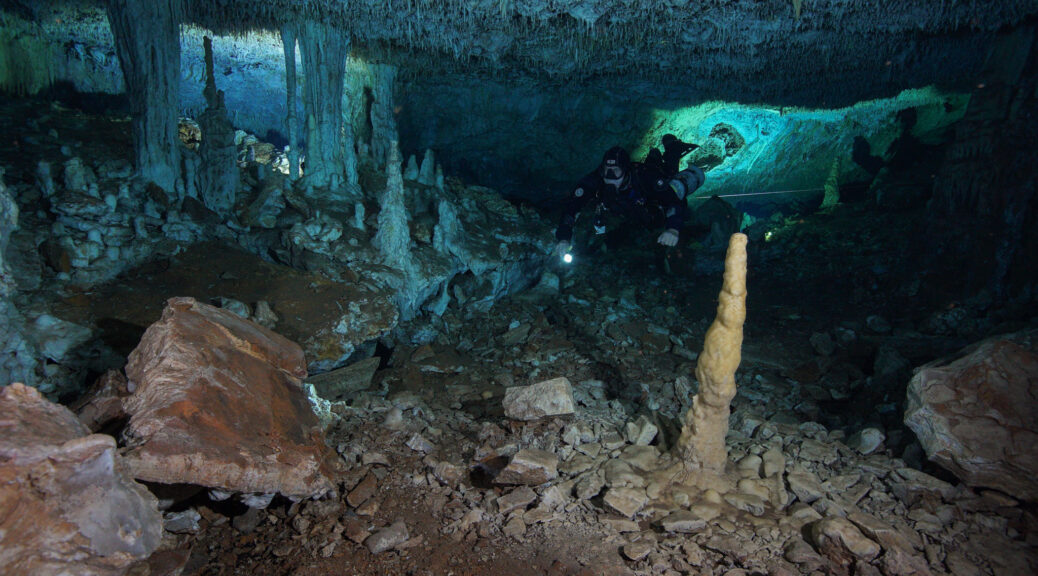
The dive team mapped 269 artifacts at Cape Bruguieres in shallow water at depths down to 2.4 meters below modern sea level. Radiocarbon dating and analysis of sea-level changes show the site is at least 7000 years old.

The second site at Flying Foam Passage includes an underwater freshwater spring 14 meters below sea level. This site is estimated to be at least 8500 years old. Both sites may be much older as the dates represent minimum ages only; they may be even more ancient.

The team of archaeologists and geoscientists employed predictive modelling and various underwater and remote sensing techniques, including scientific diving methods, to confirm the location of sites and the presence of artifacts.

Artifacts recovered from under water from Cape Bruguieres off the coast of Dampier in the Pilbara

“At one point there would have been dry land stretching out 160 km from the current shoreline. That land would have been owned and lived on by generations of Aboriginal people.

Our discovery demonstrates that underwater archaeological material has survived sea-level rise, and although these sites are located in relatively shallow water, there will likely be more in deeper water offshore” says Chelsea Wiseman from Flinders University who has been working on the DHSC project as part of Ph.D. research.

“These territories that are now underwater harboured favourable environments for Indigenous settlements including freshwater, ecological diversity and opportunities to exploit marine resources which would have supported relatively high population densities” says Dr Michael O’Leary, a marine geomorphologist at The University of Western Australia.”

The discovery of these sites emphasizes the need for stronger federal legislation to protect and manage underwater heritage across 2 million square kilometers of landscapes that were once above sea level in Australia, and hold major insights into human history.

“Managing, investigating and understanding the archaelogy of the Australian continental shelf in partnership with Aboriginal and Torres Strait Islander traditional owners and custodians is one of the last frontiers in Australian archaeology” said Associate Professor Benjamin.

“Our results represent the first step in a journey of discovery to explore the potential of archaeology on the continental shelves which can fill a major gap in the human history of the continent,” he said.

In Murujuga, this adds substantial additional evidence to support the deep time history of human activities accompanying rock art production in this important National Heritage Listed Place.

Murujuga Aboriginal Corporation CEO Peter Jeffries says the discoveries will help the community add to the story of Aboriginal people in the Pilbara.

“Further exploration could unearth similar cultural relics and help us better understand the life of the people who were so connected to these areas of land which are now underwater.

“With this comes a new requirement for the careful management of Aboriginal sea country as it’s not automatically protected by current Heritage legislation, however, plans are progressing to lead this change and protect our sea country land and heritage.”

Massive Polish Fort Walls Over 100 Feet Wide Indicate Medieval Capital

Massive Polish Fort Walls Over 100 Feet Wide Indicate Medieval Capital

The finding of three rings of fortified walls gave archeologists startling new information about Poland’s Middle Ages.

Polish fortress walls can be seen in this 1617 illustration of Poznań.

The finding of the enormous Polish fortress walls suggests that Poznan be the very first Polish capital and the people had taken full steps to protect this tactical center.

The Enormous Polish Fort Walls Can’t Stop Development

The walls determined 40 meters (13123 ft.) large and 12 meters (3937 ft.) high, which, according to The First News, indicates that these stronghold walls are “the biggest of their kind in Poland.”

They were constructed of a mix of sand, stone, and wood and would have been an enforcing view when they happily stood surrounding and safeguarding the city from its opponents over a thousand years earlier.

The archaeologists utilized photogrammetry and dendrochronology strategies to date the huge Polish prepared city walls and identified that they were constructed in between 968 and 1000.

Archaeologists found the Polish fortress’s ruins 7 meters (2297 ft.) underground while they were checking out the website which is set to be an apartment building.

The structure designer’s site states that the historical work is total and the building of the homes continues “on schedule.”

The Polish fort’s walls are made from wood, stone, and are “the biggest of their kind in Poland.”

The Indication of an Early-Medieval Capital City

Archaeology reports that the brand-new info indicates that Poznań takes over from neighboring Gniezno as the area of the nation’s very first capital city. As the chief archaeologist at the website, Antoni Smoliński, stated:

” Previously, our companied believe that Poznań was a settlement of secondary significance. Nevertheless, offered the discovery of the huge defences, this declaration is extremely doubtful.

The Early-Medieval city was, certainly, a tactical centre and the post-christening capital of Mieszko I’s Poland.”

mural in Gniezno commemorating the baptism of Mieszko I of Poland.

Poznań and St. Peter’s Sword

A previous Ancient Origins post likewise names Poznań as the house of St. Peter’s sword, mentioning that:

“During the reign of Mieszko I (ca. 960 – 992 AD), Christianity was adopted as the religion of the state. To commemorate the conversion of Poland, Pope John XIII decided to give the Sword of St. Peter as a gift, either to Mieszko I, or to Bishop Jordan, the first Bishop of Poland.

Mieszko’s center of power was in Poznan, whilst the bishop is believed to have had his seat in the same city, hence the Sword of St. Peter ended up there, regardless of whether it was the duke or the bishop who received the papal gift.”

Peter using his sword to strike Malchus (circa 1520, Musée des Beaux-Arts de Dijon).

Bible stories state St. Peter utilized the sword to trim the best ear of among the high priest’s servants on the night prior to Jesus’s crucifixion. It now sits with gold and silver spiritual antiques in the city’s Archdiocesan Museum.

Horse Burial Discovered in Central Iran

Ancient horse remains discovered in central Iran

Archeologists found an ancient burial with the bones of a horse-estimated to be four years old-in Tepe Ashraf, the sole archaeological hill in Isfahan, central Iran.

The skeleton of the horse was discovered next to the place where a giant jar-tomb was unearthed last month, which researchers believe could shed new light on ancient human life in Isfahan.

“The burial of this horse with its head turned towards the animal’s body, shows an official burial which was practiced during the early years of the Parthian era (247 BC – 224 CE).

Ancient horse remains discovered in central Iran

In this type of burial, the animal’s body was buried next to its owner, who had died,” IRNA quoted senior archaeologist Alireza Jafari-Zand as saying on Tuesday.

Jafari-Zand, who heads the archaeological excavation at the hill, explained: “Evidence came to light from some Parthian cemeteries, being excavated in northern Iran, shows that the deceased’s horse was buried next to him, and this fully shows that we have the same burial [tradition] in Isfahan, the discovery of this type of burial in Ashraf hill is of high importance for the history of Isfahan because no such phenomenon has been reported in central Iran so far.”

“Tepe Ashraf is the second place after the Tepe Sialk (in Isfahan province) that has yielded the discovery of such jar tombs that offers valuable clues to uncover the obscure history of pre-Islamic Isfahan,” Jafari-Zand said.

Excavations at Tepe Ashraf initially began in 2010 when Jafari-Zand announced his team found evidence at the site suggesting that the Sassanid site had also been used during the Buyid dynasty (945–1055).

“We stumbled upon a reconstructed part in the ruins of the castle, which suggests that the structure had been used during the Buyid dynasty

“Isfahan is a city, which has never died over the history… and the old Isfahan is beneath the modern city. Thus, normally, archaeological excavation is impossible in the city,” according to Jafari-Zand who believes that the mount keeps a part of the history of Isfahan and Iran in its heart.

The mound has seriously been damaged on the northern side by the construction of a street. Besides, unscientific excavations carried out by several archaeology interns in 1987 disturbed the historical strata in a part of the site.

Soaked in a rich history, Isfahan was once a crossroads of international trade and diplomacy in Iran during the 16th and 17th centuries, and now it is one of Iran’s top tourist destinations for good reasons.

Isfahan is filled with architectural wonders such as unmatched Islamic buildings, bazaars, museums, Persian gardens, and tree-lined boulevards.

It’s a city for walking, getting lost in its mazing bazaars, dozing in beautiful gardens, and meeting people. It has long been nicknamed as Nesf-e-Jahan which is translated into “half of the world”, suggesting that seeing it is equivalent to seeing half of the world.

Over half a century ago, deep in the jungles of Guatemala, a gigantic stone head was uncovered 

Over half a century ago, deep in the jungles of Guatemala, a gigantic stone head was uncovered

The face had fine features, thin lips, and a large nose, and its face was directed up at the sky.  Unusually, the face demonstrated Caucasian features that were not consistent with any of the pre-Hispanic races of America.  The discovery rapidly attracted attention, but just as quickly it slipped away into the pages of forgotten history.

News of the discovery first emerged when Dr. Oscar Rafael Padilla Lara, a doctor of philosophy, lawyer and notary, received a photograph of the head in 1987 along with a description that the photograph was taken in the 1950s by the owner of the land where the head was found and that it was located “somewhere in the jungles of Guatemala”. 

The photograph and story were printed in a small article in the newsletter ‘Ancient Skies’, which was picked up and read by well-known explorer and author David Hatcher Childress, one of our guest authors at BBC, who sought out to discover more about the mysterious stone head.

He tracked down Dr. Padilla who reported that he found the owners of the property, the Biener family, on which the monolith was found. The site was 10 kilometers from a small village in La Democracia in the south of Guatemala.

However, Dr. Padilla said that he was in despair when he reached the site and found that the site had been obliterated: “It was destroyed by revolutionaries about ten years ago. We had located the statue too late. It was used as target practice by anti-government rebels. This totally disfigured it, sort of like the way the Sphinx in Egypt had its nose shot off by the Turks, only worse,” he said.

The eyes, nose, and mouth had completely gone. Padilla was able to measure its height as between 4 and 6 meters, with the head resting on a neck. Padilla did not return again to the site due to armed attacks between government forces and rebel forces in the area. 

The destruction of the head meant the story died a rapid death until it was picked up again a few years ago by filmmakers behind “ Revelations of the Mayans 2012 and Beyond ” who used the photograph to claim that extra-terrestrials have had contact with past civilizations.

The producer published a document written by Guatemalan archaeologist Hector E Majia who wrote: “I certify that this monument presents no characteristics of Maya, Nahuatl, Olmec or any other pre-Hispanic civilization.

It was created by an extraordinary and superior civilization with awesome knowledge of which there is no record of existence on this planet.”

However, far from helping the cause and the investigation into the monolith, this publication only served to have the opposite effect, throwing the whole story into the hands of a justifiably skeptical audience who thought that it was all just a publicity stunt. Even the letter itself has been drawn into question with some saying that it is not genuine. 

Nevertheless, it appears the giant head did exist and there is no evidence to suggest the original photograph is not authentic or that Dr. Padilla’s account was false.  So assuming it was real, the questions remain: Where did it come from? Who made it? And why?

The region where the stone head was reported to have been found, La Democracia, is actually already famous for stone heads which, like the stone head found in the jungle, also face skyward. 

These are known to have been created by the Olmec civilization, which flourished between 1400 and 400 BC.  The Olmec heartland was the area in the Gulf of Mexico lowlands, however, Olmec-style artifacts, designs, monuments, and iconography have been found in sites hundreds of kilometers outside the Olmec heartland, including La Democracia. 

Nevertheless, the stone head depicted in the 1950s photograph does not share the same features or style as the Olmec heads.  The late Phillip Coppens, Belgian author, radio host and TV commentator on matters of alternative history raised the question of whether the head “is an anomaly of the Olmec period, or whether it is part of another – unknown – a culture that predated or post-dated the Olmecs, and whose only artifact identified so far is the Padilla head”.

Other questions that have been posed include whether the structure was just a head, or whether there was a body underneath, like the Easter Island statues, and whether the stone head is linked to any other structures in the region. 

It would be nice to know the answers to these questions but sadly it appears the publicity surrounding the film “Revelations of the Mayans 2012 and Beyond” only served to bury the story deeper into the pages of history.  Hopefully an ambitious explorer will pick up the story once again and investigate further to find the truth regarding this enigmatic monument.

11,000-year-old mine in the underwater cave found by archaeologists

11,000-year-old mine in the underwater cave found by archaeologists

Paleoindian ochre mining has been found by divers in three underwater caves near Akumal, on the coast of the Yucatán Peninsula in Mexico.

From the Maya era, the cave’s were a source of mineral and pigment but they were long preceded by mining activity in this Cave at the end of the latter ice age, 12,000 years ago, and 2000 more. That makes this cave networks the oldest known mine in the Americas.

The cave became submerged with the postglacial rise of sea levels about 8,000 years ago and the saltwater in limestone caves helped preserved the archaeological evidence left by the ancient miners.

Over the course of 100 dives since 2017, underwater archaeologists from the National Institute of Anthropology and History (INAH) divers with the Research Center for the Aquifer System of Quintana Roo (CINDAQ) have explored more than four miles of tunnels and passages in three cave systems.

A recent survey of a half-mile section of passages known as La Mina revealed 155 stacks of stones, tools, charcoal remains of human-set fires on the floor, soot accumulation on the ceiling and most probative of all, pits and trenches carved out of the floor where trace mineral analysis found ocher residue.

Stalactites and stalagmites were deliberately broken to allow people and materials to navigate the narrow passages. The flowstone floor was cracked and shattered to extract the ochre underneath it. Broken stalactite/stalagmites were used as hammerstones. Piles of mine spoil line the walls.

There was a comprehensive mining program, all of it done in the dark areas of the cave. The closest natural light source was at a minimum of 650 feet away, more than 2,000 feet away at the furthest point.

“The cave’s landscape has been noticeably altered, which leads us to believe that prehistoric humans extracted tonnes of ocher from it, maybe having to light fire pits to illuminate the space,” points out Fred Devos.

Until now, no human skeletal remains have been found; however, rudimentary digging tools, signs —that would have been used in order not to get lost— and stacks of stones left behind by this primitive mining activity have been located.

The abundance of ocher filled cavities has led experts to theorize about the rocks themselves being used as tools to excavate and break down the stone.

Iron-rich red ochre was used by humans for tens of thousands of years. The mineral pigment was used in rock art, funerary rituals, pottery decoration, and personal adornment.

In ancient America, ochre has been discovered in art, on human remains, in toolkits, on grinding stones, in tanned hides, and much more. La Mina’s ochre was of particularly high quality, very pure in iron oxide and composed of particles so fine-grained that it was basically ready for use as paint as soon as it was mined.

Skeletal remains have been discovered in other cenotes. The 12,000-year-old skeleton of a teenage girl dubbed Naia found in the cenote of Hoyo Negro near Tulum less than 20 miles southwest of Akumal is the oldest complete human skeleton in the Western Hemisphere.

Naia was a contemporary of the miners who sought ochre in caves 15 miles away from her final resting place.

The discovery that these cave systems were mined for thousands of years opens up the possibility that instead of falling victim to an accident — the going theory as regards Paleoindian remains in cenotes — individuals like Naia may have been scouting caves for valuable ochre.

The face of a 7500-year-old woman reveals Gibraltar’s earliest humans

The face of a 7500-year-old woman reveals Gibraltar’s earliest humans

The Minister of heritage Dr. John Cortes unveiled a historical reconstruction of the head of a Neolithic woman who lived in Gibraltar 7,500 years ago.

Archeologists who worked in the Gibraltar National Museum discovered and excavated their remains, called “Calpeia,” the classical name of the Rock from a burial site near Europa Point in 1996.

Recent advances permitted segments of her DNA to be extracted. A combination of the technology currently available and the skills of Gibraltar National Museum Conservator, Manuel Jaen, had made this in-house project a reality.

Assisting Dr Cortes at the unveiling was Director of the museum Professor Clive Finlayson, Dr Geraldine Finlayson, Stewart Finlayson and Mr Jaen.

Human hair was used in the reconstruction process that took Mr Jaen six months. Holding a 3D printed version of the skull found in 1996 during an excavation, Professor Finlayson explained the process of how Calpeia came to be.

“She was in a burial and we now know she was a she as she comes from the Neolithic period of around 5,400BC.”

“We were able to extract DNA from the skull so we know a number of things.”

“We know she was a female, we know she had features associated with dark hair, dark eyes and the interesting thing was when we look at her ancestry 10% of her genes were local Mesolithic hunter gathers but 90% of her genes were from Anatolia [modern day Turkey],” he said.

“I am not going to go into the ins and outs of Neanderthals being different species or not, but if the Neanderthal is a different linage and Nana is the first female Neanderthal, I think what you are going to see today is truly a modern human,” he added.

“Through Forensic data, & the key word is ‘forensic’, we have created Calpeia”

Calpeia’s skull had been deformed post-burial so the process of her reconstruction included the reshaping of a scanned copy of the skull, and completing the missing areas.

Dr Cortes described the work that Mr Jaen and the museum carried out as “extraordinary”.

He said: “When I saw what you are about to see a few days ago it was breath-taking, congratulations to Manuel for this incredible piece of work.”

“This young lady, I think she was late 30s early 40s, lived in Gibraltar seven and a half thousand years ago. She was buried in a cave at Europa Point.”

“I am told there was no agriculture in Gibraltar at that time, they were probably fishing living off the sea and living off the land.”

“But she was in Gibraltar, a Gibraltarian, though whether she was born here or travelled here we will never know. But, so many of us born here or who have travelled here consider ourselves Gibraltarian,” he added.

Dr Cortes said he, like Professor Finlayson, would not be drawn on whether Neanderthals are or not the same species as modern humans but stated that Calpeia was not a Neanderthal.

“So you are about to see the face of the first known Gibraltarian of seven and a half thousand years ago,” he said.

“So when you see her try and push your mind back all those years ago when the Rock was very, very different, still our Rock, still our Gibraltar, still lived, played and suffered and had their day to day life in a different way but they were humans just like us with the same emotions.”

The secret cave lies hidden below the enormous ‘Moon Pyramid’

The secret cave lies hidden below the enormous ‘Moon Pyramid’

A secret cave hidden underneath a Mexican pyramid offers clues about the urban design of Teotihuacan, one of the largest and most vibrant cities of ancient times.

Located about 80 kilometers outside of today’s Mexico City, Teotihuacan peaked in AD 300–650, well before the Aztecs. The city boasted three monumental pyramids arranged along the 2.4-kilometer ‘Street of the Dead’.

Two of the pyramids were already known to overlie caves and tunnels, which were excavated by Teotihuacanos to obtain construction materials, and were later repurposed for activities such as astronomical observations, the veneration of death and the enthronement of rulers.

Denisse Argote at the National Institute of Anthropology and History in Mexico City and her colleagues measured the electrical resistance of the ground beneath the third structure, the 43-meter-high Moon Pyramid.

They discovered a partially filled cavern about 15 meters underneath the edifice.

Unlike the other caves, this one seems to have formed naturally. Argote and her colleagues think the first settlers of Teotihuacan might have chosen it to be the focal point from which the rest of the city was planned.

Hard Science Unlocks Secrets of Teotihuacan’s Pyramid of the Moon

Previous archaeological digs at Teotihuacan have revealed a series of man-made tunnels beneath the Pyramids of the Sun and of Quetzalcoatl, the latter of which is also called the Temple of the Feathered-Serpent.

These had mostly been excavated for construction materials in upper structures, and according to a report in Heritage Daily, these tunnels were later “repurposed for astronomical observations and for venerating death in the underworld.”

The team of scientists applied ERT and ANT surveys, which are non-invasive geophysical techniques analyzing the electrical resistance of the ground beneath the structure.

They identified a natural void beneath the Pyramid of the Moon and a partially filled cavern at a depth of 15 meters (49 ft.) Contrasting with the man-made tunnels beneath the Pyramid of the Sun and the Pyramid of Quetzalcoatl at Teotihuacan, the researchers believe that the cave under the Pyramid of the Moon “formed naturally,” and had been a focal point for the early settlers, in turn, influencing how the city was planned out.

Otherworldly Architectural Town Planning

With the placement of the pyramid at the end of the Avenue of the Dead, at the foot of Cerro Gordo, shaped to reflect the contours of these mountains, the researchers theorize that it was “symbolic of a connection between the avenue and the watery underworld, whereas the mountain serves as an anchor to the earth.” They said the impact of this discovery opens a discussion about the original planning of Teotihuacan ’s urban design.

The discovery under Teotihuacan’s Pyramid of the Moon help’s explain the city’s urban design.

The first human establishment in the area dates back to around 600 BC when farmers began tilling the Teotihuacan Valley, which at that time had a total population of about 6,000 inhabitants.

However, due to the development of successful agricultural technologies, from 100 BC to 750 AD, Teotihuacan morphed into a huge urban and administrative center with cultural influences throughout Mesoamerica.

Mapping the Ancient Underworld

Period III, from 350 to 650 AD, the so-called classical period of Teotihuacan, had an estimated 125,000 inhabitants. At that time it was one of the largest cities of the ancient world – with over 2,000 buildings in an 18 square kilometer (6.95 sq. mile) area. 

This period saw the massive reconstruction of monuments; including the decorating of the Temple of the Feathered Serpent which dates back to an earlier period.

Period IV, between 650 and 750 AD, marks the end of Teotihuacan as a major power in Mesoamerica. The remains of the homes of the city’s elites, which line the Avenue of the Dead, bear burn marks which lead archaeologists to hypothesize that the city experienced waves of violent social unrest that brought about the city’s decline.

What the newly discovered cave system essentially does is answer the question “why” the first settlers stopped here and started building precisely where they did, and not say 10 miles east or five miles south.

The cave beneath the pyramid suggests that people revered this natural access to the underworld so much that around it they built one of the most influential and biggest cities of the ancient world.

And the remains of that vast crumbling ancient city, which was aligned with the Sun, moon, and stars, it would seem, is a 1:1 map of the underworld – with the Avenue of the Dead acting as the main channel to the other side.

Giant Egyptian Pyramids Hidden Beneath, buried by sands of time

Giant Egyptian Pyramids Hidden Beneath, buried by sands of time

Indiana Jones found success with little more than a bullwhip and a fedora. These days, however, if you want to make your mark as an archaeologist, a bit of space technology works wonders.

Satellites have helped locate 17 pyramids and 3,000 ancient settlements hidden underground in Egypt. More than 1,000 burial sites were also discovered thanks to infra-red technology capable of probing beneath the desert sands from 450 miles above the Earth.

Astounded researchers on the ground have already confirmed that two of the pyramids exist – and they believe there are thousands more unknown sites in the region.

satellite images revealed strange structures

NASA-funded archaeologist Sarah Parcak said: ‘I couldn’t believe we could locate so many sites. To excavate a pyramid is the dream of every archaeologist.’ The finds are hugely significant. Until the latest discoveries there were thought to have been almost 140 pyramids across Egypt.

But experts have long argued that there must be many more that remain undiscovered, buried by the sands of time. Dr Parcak, from the University of Alabama at Birmingham, analysed images from satellites equipped with cameras so powerful they can zoom in on objects less than three feet in diameter on the Earth’s surface.

Huge pyramids could be buried beneath the sand. 

Dr. Parcak told the BBC: ‘I could see the data as it was emerging, but for me, the “a-ha” moment was when I could step back and look at everything that we’d found.’

The mud bricks used by ancient Egyptians are much denser than the sand and soil that surrounds them, allowing the shapes of homes, temples, tombs and other structures built thousands of years ago to be seen by satellites orbiting 435miles above Earth to photograph the outlines of structures invisible to the human eye.

The cameras on the satellites are so powerful that they can precisely image objects on Earth that are less than one metre in diameter. The researchers’ findings are a major boost to the relatively new science of space archaeology.

Their most promising excavations are taking place in Tanis, the hiding place of the Ark of the Covenant in the 1981 Indiana Jones blockbuster Raiders of the Lost Ark, where they are uncovering a 3,000-year-old house.

Excitingly, the outline of the house exactly matches the shape seen on the satellite images.

Two pyramids at Saqqara – the burial ground for the ancient capital of Memphis – have already been confirmed by excavations and the site is being hailed as one of the most important in Egyptian archaeology. The oldest pyramids ever discovered were built in Saqqara around 2,600BC.

Archaeologist Dr Sarah Parcak points out the site of a buried pyramid on a satellite image

The camera’s high level of accuracy has impressed the Egyptian government, which now plans to use the technology to identify and protect its colossal heritage in the future.

Dr Parcak believes that there are many more buildings buried deeper than those already spotted, the most likely location being under the banks of the River Nile.

She said: ‘These are just the sites close to the surface. There are many thousands of additional sites that the Nile has covered over with silt.

‘This is just the beginning of this kind of work.’

She told the BBC: ‘It just shows us how easy it is to underestimate both the size and scale of past human settlements.

‘These are just the sites [close to] the surface. There are many thousands of additional sites that the Nile has covered over with silt. This is just the beginning of this kind of work.’

She said the technology could be used to monitor the looting of antiquities, as well as to engage young people around the world in science and help archaeologists in their quest to uncover the secrets of the past.

The archaeologist said, ‘We have to think bigger and that’s what the satellites allow us to do. Indiana Jones is old school. We’ve moved on from Indy, sorry Harrison Ford.’