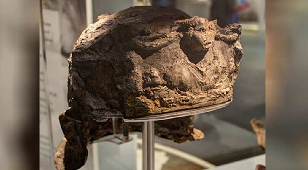
The 2,000-year-old Hallaton helmet is the only Roman helmet ever Found in Britain
At the British Museum, a silver-gilt Roman helmet of excellent quality and world value found as part of the Hallaton Treasure and ArtFunded in 2007 was returned to its former glory.
The discovery was purchased by the Leicestershire County Council for exhibition at the Harborough Museum and the helmet was restored and repaired with the expertise at the British Museum due to Heritage Lottery funding.
Discovery
Archaeologists who made the original discovery at Hallaton in Leicestershire, used to finding more glamorous gold and silver coins, joked they had found a fairly modern “rusty bucket”. Little did they know at the time what a hugely significant archaeological find they had come across.
The “Hallaton Helmet” was found ten years ago by members of the Hallaton Fieldwork Group and professional archaeologists from the University of Leicester Archaeological Services who were excavating the remains of a 2,000-year-old Iron Age shrine.
The site appears to be a major religious center, having produced the largest number of Iron Age coins ever excavated in Britain and possible evidence of ritual feasting dating to the mid-1st century AD.
The helmet would probably have been designed for ceremonial occasions
The finds from this site would later become known as the Hallaton Treasure.
On display
The helmet was too fragile to be excavated in situ so it was removed within a block of earth held together with plaster of Paris.
It was taken to the British Museum in London for conservation, which took nine years of work by conservator Marilyn Hockey and her colleagues Fleur Shearman and Duygu Çamurcuoğlu.
Corrosion and the effects of time had shattered the helmet into thousands of pieces, most of which were smaller than the nail on a person’s little finger. The reconstructed and conserved helmet was unveiled in January 2012.
Leicester County Council was able to raise £1 million to buy the entire hoard and pay for the conservation of the helmet, with the assistance of donations from the Heritage Lottery Fund (which gave a £650,000 grant), the Art Fund and other trusts and charities.
The helmet was valued at £300,000; under the terms of the Treasure Act, Ken Wallace and the landowner were each awarded £150,000.
The helmet was put on permanent public display at the end of January 2012 at the Harborough Museum in Market Harborough, nine miles from the site where the hoard was found, alongside other objects found at Hallaton.
A man’s discovery of bones under his pub could forever change what we know about the Irish
10 Years ago, an Irish pub owner was clearing land for a driveway when his digging exposed an unusually large flat stone. The stone obscured a dark gap underneath. He grabbed a flashlight to peer in.
A photo of McCuaig’s Bar on Rathlin Island in Northern Ireland. Ancient bones were unearthed on the property in 2006.
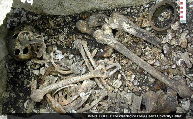
“I shot the torch in and saw the gentleman, well, his skull and bones,” Bertie Currie, the pub owner, said this week. The remains of three humans, in fact, were found behind McCuaig’s Bar in County Antrim, Northern Ireland. And though police were called, it was not, as it turned out, a crime scene.
Instead, what Currie had stumbled over was an ancient burial that, after a recent DNA analysis, challenges the traditional centuries-old account of Irish origins. From as far back as the 16th century, historians taught that the Irish are the descendants of the Celts, an Iron Age people who originated in the middle of Europe and invaded Ireland somewhere between 1000 B.C. and 500 B.C.
Yet the bones discovered behind McCuaig’s tell a different story of Irish origins, and it does not include the Celts.
“The DNA evidence based on those bones completely upends the traditional view,” said Barry Cunliffe, an emeritus professor of archaeology at Oxford who has written books on the origins of the people of Ireland.
DNA research indicates that the three skeletons found behind McCuaig’s are the ancestors of the modern Irish and they predate the Celts and their purported arrival by 1,000 years or more. The genetic roots of today’s Irish, in other words, existed in Ireland before the Celts arrived.
“The most striking feature” of the bones, according to the research published in the Proceedings of the National Academy of Science journal, is how much their DNA resembles that of contemporary Irish, Welsh, and Scots. (By contrast, older bones found in Ireland were more like Mediterranean people, not the modern Irish.)
Radiocarbon dating shows that the bones discovered at McCuaig’s go back to about 2000 B.C. That makes them hundreds of years older than the oldest artifacts generally considered to be Celtic–relics unearthed from Celt homelands of continental Europe, most notably around Switzerland, Austria and Germany.
These bones were discovered behind McCuaig’s Bar in County Antrim, Northern Ireland. DNA analysis of them challenges conventional history.
The senior author of the DNA research paper, Dan Bradley of Trinity College Dublin, was reluctant to weigh in on the cultural implications, but he offered that the findings do challenge popular beliefs about Irish origins.
“The genomes of the contemporary people in Ireland are older–much older–than we previously thought,” he said.
Geneticists from Trinity College Dublin, and archaeologists from Queens University Belfast, have sequenced the first genomes from ancient Irish humans.
Numerous digs, most notably in Austria and Switzerland, have traced the outlines of the Celts. The artifacts offer evidence going back as far as about 800 B.C. The ancient Greeks and Romans also left written accounts of the Celts, and probably knew them well–the Celts sacked Rome around 390 B.C. and attacked Delphi in Greece in 279 B.C.
It seemed plausible that this group that had invaded Rome had invaded Ireland as well, and in the standard view, it was this people that eventually made it to Ireland. For decades, however, archaeologists and other scholars have noted just how flimsy the evidence is for that standard account and how broad, nonetheless, is the application of the word.
In a 2001 book, Cunliffe, the Oxford scholar, argued on the basis of archaeological evidence that the flow of Celtic culture was opposite that of the traditional view–it flowed from the western edge of Europe, what he calls “the Atlantic zone”–into the rest of the continent. In many places of the Atlantic zone, he notes, people were buried in passages aligned with the solstices, a sign that they shared a unified belief system.
“From about 5,000 B.C. onwards, complicated ideas of status, art, cosmology were being disseminated along the Atlantic seaways,” Cunliffe said, and that culture then spread eastward.
“If we’re right, the roots of what is known as ‘Celtic’ culture go way way back in time,” Cunliffe said. “And the genetic evidence is going to be an absolute game-changer.”
This heat map shows how the DNA taken from the 4,000-year-old bones discovered in Northern Ireland relates to the DNA of modern European populations. The red coloring over the British Isles indicates that the bones are most like the modern populations there.
If the new scholarship proves correct, exactly what to do with the word Celtic will probably be a matter of some dispute: Should it be applied to languages or cultures that, no matter how clearly defined, were largely uninfluenced by the historical Celts of continental Europe?
Complicating any answer are old ethnic antagonisms: The old notions of a distinct “Celtic race” or “Irish race” have been used not just for poetic tributes, but for scorn.
The new evidence from genetics, however, undermines notions of a separate Irish race, describing them instead as one sliver of the European spectrum. According to the genetic research, the Irish are at the extreme end of a genetic wave that washed across Europe, a wave of migrants that swept westward from above the Black Sea across Europe about 2,500 B.C.
That wave of migration had been documented in previous research led by David Reich at Harvard University, but it was unclear whether it had extended all the way to Ireland. The Y chromosome and other aspects of the DNA in the bones found behind McCuaig’s, however, link the Irish to that surge of population.
This bright metallic meteorite crashed in India, and it looks pretty cool
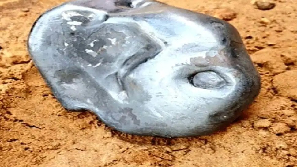
A meteorite-like object weighing about 2.8 kilograms fell from the sky in Sanchore town of Rajasthan’s Jalore district. The mysterious object, which is believed to be worth crores of rupees, created a one-foot-deep crater in the ground.
The locals informed the police and local administration about the incident. The local police said that several villagers heard an explosive sound when the object fell from the sky and they rushed to the field to see the meteorite-like object. It is learned that the explosion was heard as far as two kilometers.
It was only after a while that we were able to find an object lying in a 30-centimeter crater. It fell only 100 meters from my house. We immediately notified the authorities,” said Ajmal Devasi, one of the many people who were left stumped by the object.
The meteorite, which stands out for its shiny metallic appearance, weighs around 2.78 kilograms.
According to local reports, it continued to emit heat even three hours after its fall, leading many residents of the area to think it could explode at any time.
Meteorite like object falls in Sanchor area in Jalore district at 7 AM on Friday, (June 19, 2020 ) The object weighs 2.78 Kg approx As per geologists, it is a metallic meteorite – very rare and most valuable.
After it had cooled down, the authorities collected the meteorite and put it in a jar for transport. The police have stated that it has been made available to experts for study and that more details about its origin and composition will soon be known.
Images of the meteorite were shared on Twitter, generating great amazement and a number of responses.
This event occurred a few days after a spectacular green fireball crossed the skies of Australia, taking skywatchers by surprise.
The object appeared shortly before 1:00 a.m. (local time) last Monday, according to witness reports from the Pilbara region of Western Australia, Northern Territory, and South Australia.
According to rough estimates, around 500 meteorites survive the entry through Earth’s atmosphere, reaching the surface of the planet each year. Despite this, no more than ten are recovered each year.
This is because many of these meteorites crash into the ocean or land in remote areas on Earth, crashing in places that are not easy to access.
Furthermore, some meteorites crash into the surface during the daytime, which means that they go undetected.
Astronomers can’t generally predict meteorite impacts because most meteoroids traveling in outer space are simply too small to detect.
According to NASA, it is estimated that around 48.5 tons (44,000 kilograms) of meteoritic material falls on Earth each day.
When a meteoroid survives its trip through the atmosphere and hits the ground, it’s called a meteorite.
DNA tests are used for many things. They can prove if someone was involved in a crime and a paternity testing clinic can find out if a child really is their son or daughter by comparing their DNA. A growing trend with DNA testing is to trace back genetic ancestry and one man may have found he has the oldest DNA in America.
A new client has taken the status of the oldest traceable DNA in the Americas, according to one genetic company. A Great Falls Tribune article shows the DNA of Alvin ‘Willy’ Crawford traced back 55 generations with a shocking 99 percent accuracy, making his lineage the longest ever traced by CRI Genetics, the ancestry testing company.
The genetic tests, according to the study, traced Crawford’s DNA back a whopping 17,000 years.
The length and accuracy of Crawford’s lineage are so rare that the company told Crawford’s family that it was ‘like finding Big Foot.’
The DNA test traced Crawford’s family history to ancestors that migrated across the Bering Land Bridge. Many of Americas first humans crossed a narrow land bridge that stretched across the Bering Sea and into Alaska (illustrated above)
According to the report, Crawford died of a heart attack shortly before the results of CRI’s genetic testing had concluded, but was told that his ancestors had migrated across the Bering Land Bridge during an Ice Age.
According to Crawford’s DNA, however, he belonged to the mtDNA Haplogroup B2 — a genetic subgroup — which is very common in southwestern America.
Likely, Crawford’s ancestors traveled from Asia to South America and traveled north according to CRI.
Crawford’s DNA was 83 percent native American according to the report, with 73 percent of that coming from one tribe alone, the Blackfeet Nation.
As the ability to sequence and understand genomes has steadily advanced, so too has our understanding of the way species, including humans, have evolved.
In 2010, a bit of luck led to the first fully sequenced genome of early humans.
Scientists were able to map the entire genome of an early ancient human after analyzing a 4,000-year-old hairball found frozen in Greenland soil — the piece of genetic history pales in comparison to other ancient human DNA which has been dated as far back as 430,000 years.
Similarly, after studying the discovered DNA of a six-week-old Native American infant who died 11,500 years ago, researchers revealed last year that humans likely migrated across the Bering Strait land bridge into Alaska in one fell swoop as opposed to coming in waves like previously thought.
For individuals in Native American communities like that to which Crawford and his family belong, the impacts of genetic testing have had more personal ripple effects.
According to genetics company CRI, Alvin Crawford has the oldest traceable DNA in the companies history. Alvin died before the results came in, but his family says he would have been ‘blown away.’ His brother, Darrell “Dusty” Crawford, is pictured
Genetic testing is now used, to some controversy, to test people’s enrollment in tribes — if tests come back under certain percentages of a tribe’s DNA then they may not be allowed in.
Arguments over Native American ancestry have even made the national stage, namely through a public spat between the presidential candidate, Senator Elizabeth Warren, and President Donald Trump over Warren’s alleged Native American background.
To prove her claim, she resorted to genetic testing.
A Representative from CRI Genetics did not respond to a request for comment before the time of publication.
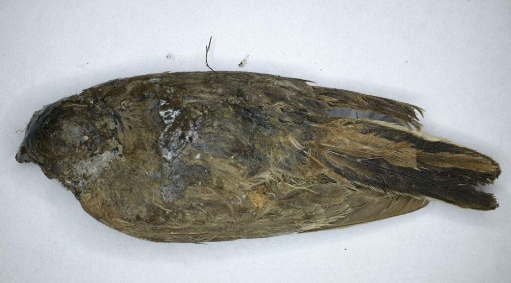
For the past 46,000 years, a small bird that perished in the last ice age was frozen, protected from deterioration and scavenger until the body in Siberian permafrost was found by two Russians searching for fossil mammoth tusks.
Love Dalén, a professor of evolutionary genetics at the Centre for Palaeogenetics in Stockholm, who was with the ivory hunters, Boris Berezhnov and Spartak Khabrov, when they spotted the bird, said that the bird was in such fine condition that it seemed “like it had] died just a few days ago,”
Dalén told Live Science in an email. “The bird is in pristine condition,” The discovery is remarkable, as “small animals like this would normally disintegrate very quickly after death due to scavengers and microbial activity.”
The frozen flier is a one-of-a-kind find, too: It’s the only near-intact bird carcass documented from the last ice age, Dalén added.
When the fossil hunters first uncovered the bird in September 2018, Dalén and his colleagues had no idea of the mystery bird’s age or species. So, Dalén “collected a couple of feathers and a small piece of tissue for radiocarbon dating and DNA sequencing,” he said.
The 46,000-year-old bird’s delicate feet are still in good shape.
He brought the ice age samples to his lab, where postdoctoral researcher Nicolas Dussex, the lead author of a new study on the bird, analyzed the remains.
Radiocarbon dating revealed that the bird lived during the same time as other ice age beasts, including mammoths, horses, woolly rhinos, bison, and lynx.
To discover the bird’s species, the researchers sequenced its mitochondrial DNA, genetic data that is passed down through the maternal line.
Although the bird’s mitochondrial DNA was fragmentary — there were “many millions of short DNA sequences,” Dalén said, a common occurrence in ancient specimens — the team was able to piece together these short sequences with the help of a computer program.
Then, the scientists took the finished mitochondrial DNA puzzle and searched for a match in an online database that has the genetic sequences of nearly every bird alive today. The results revealed that the ice age bird was a female horned lark (Eremophila alpestris).
This discovery sheds light on the transformation of the so-called mammoth steppe. When this bird was alive, the land was a mix of steppe (unforested grassland) and tundra (treeless, frozen ground), according to pollen records from 50,000 to 30,000 years ago.
When the last ice age ended about 11,700 years ago, the mammoth steppe transitioned into the three main Eurasian environments that exist today: the northern tundra, the taiga (a coniferous forest) in the middle, and the steppe in the south said Dalén, the senior researcher on the new study.
Nowadays, there are two subspecies of horned lark: “one living on the tundra in the far north of Eurasia and the other in the steppe in the south, in Mongolia and its neighboring countries,” Dalén said.
The horned lark (Eremophila alpestris), also known as the shore lark in Europe, is a small songbird that breeds across the northern hemisphere. It has 42 formally recognized subspecies that are divided into six different clades, each of which could warrant reclassification into distinct species clusters.
It appears that the newly discovered bird is an “ancestor of two different subspecies of the horned lark,” he said. As the environment changed, however, the horned lark diverged into the two evolutionary lineages that exist today, Dalén said.
“So all in all, this study provides an example of how climate change at the end of the last ice age could have led to the formation of new subspecies,” he said.
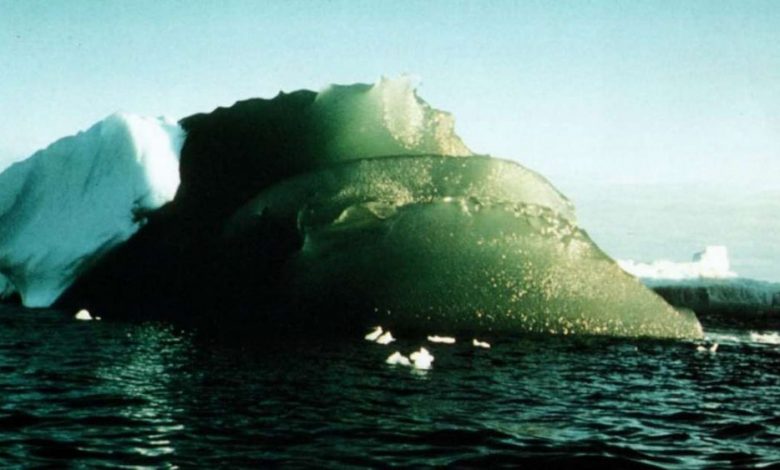
The Mystery Behind the “Rare Emerald Icebergs” of Antarctica
For decades, the sight of bottle-green icebergs in the Antarctic has captivated polar travellers and scientists. The mysterious phenomena have intrigued many journals, but the “why for their presence has remained enigmatic. Today scientists have suggested a new theory of why these jade bergs are happening, and if verified, a decades-long enigma will be solved.
During an Australian expedition in 1988, the search to discover the secret of the green monoliths started when glaciologist Stephen Warren from the University of Washington climbed up on one to get a better look at it.
“What is most amazing is not their colour but rather their clarity, because they have no bubbles,” said Warren to IFLScience.
Ordinary icebergs, on the other hand, originate as snow and “as the snow is compressed under its own weight into ice, the air in the snow is closed off as bubbles. So glacier ice contains numerous bubbles, and icebergs are bright and cloudy.”
The emerald ice, however, has no bubbles, suggesting it is not ordinary glacier ice. Warren took a core sample from a glacier near East Antarctica’s Amery Ice Shelf and compared it to other green ice samples from Australian expeditions in the 1980s. He found that the clear jade colouration was due to marine ice, not glacier ice.
Most icebergs seen by sailors in Antarctica are white or blue, some are even striped.
Green is a rarity. At first, Warren’s team suspected impurities in the ocean water beneath were transforming the ice green, perhaps from the trapped microscopic particles of dead marine plants and animals. But a sample of the ice proved their theory wrong: green and blue marine ice have similar amounts of organic material.
Researchers on top of a large composite iceberg in October 1996.
It wasn’t until a few years ago that Warren was inspired to have another go at an idea. His inspiration was born from research by oceanographer Laura Herraiz-Borreguero at the University of Tasmania, who found that the Amery Ice Shelf core had nearly 500 times more iron than the glacial ice above.
He wondered if it was possible iron oxides are turning the common blue hue of ice a dark green. If so, where was the iron coming from? These compounds are scarce in many regions of the ocean.
Warren believes the answer may lie in “glacial flour” – the powder formed from glaciers grinding over bedrock, eroding particles from the surface. These iron-rich particles then flow into the ocean and become caught under an ice shelf, where they mingle with the marine ice as it forms.
The finding could play a role in sustaining life in the oceans. Iron is a key nutrient for the microscopic plants upon which many other organisms rely. If the green icebergs are shuttling iron from Antarctica’s mainland to the Southern Ocean, it could be a crucial process to marine life.
“Iron is the limiting nutrient for phytoplankton in the Southern Ocean, so the biological oceanographers are keen to quantify the various sources of iron,” said Warren, whose study is published in the Journal of Geophysical Research: Oceans.
“Phytoplankton are the base of the food chain in the Southern Ocean. The photosynthesis by this phytoplankton also removes CO2 from the atmosphere, so they are important in the global carbon cycle.
With global warming, if the ocean water flowing in under the ice shelf becomes warmer, then probably less marine ice will form, and less iron will be delivered to the phytoplankton.”
To confirm their hypothesis, the team recommend further analysis of short cores from icebergs to measure dissolved organic carbon and particulate organic carbon versus depth, as well as the mineralogy of the iron.
In the future, Warren, Herraiz-Borreguero, and her advisor Delphine Lannuzel hope to work together to sample icebergs for iron and measure their reflectance spectra.
This Green Iceberg was spotted on February 16th, 1985, in Antarctica.
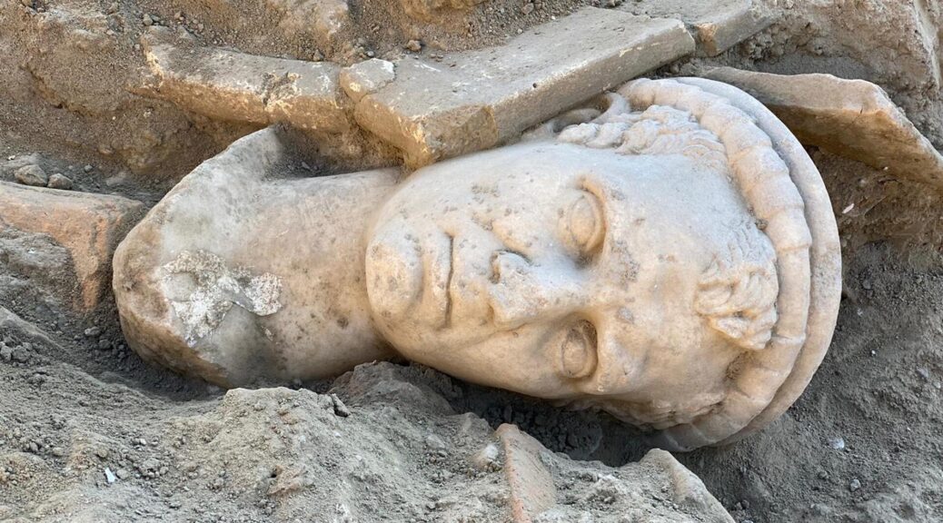
Excavation in Western Turkey Reveals 2,000-Year-Old Sculpture
Hurriyet Daily News reports that a fragment of a sculpture depicting the head of a priest has been unearthed in the large ancient city of Laodicea, which is located in western Turkey.
Laodicea on the Lycus, situated in the western province of Denizli, was an ancient metropolis and an obscure archaeological site prior to 2003. The city came to light only after the excavation activities that were started by the Denizli Museum.
A team of Turkish archaeologists headed by Pamukkale University’s Professor Celal Şimşek has been working in Laodicea continuously.
Speaking to Anadolu Agency, Şimşek said that they have unearthed an exciting artefact in the 15,000-seat western theatre of the 7,500-year-old city.
Noting that they are trying to restore the theatre by preserving it precisely, Şimşek said that they found a priest statue, which was believed to be around 2,000 years old, during the excavation works.
“There was an eight-meter embankment next to the fortification wall extending west from the stage building of the theatre and was built at the beginning of the fifth century.
We encountered a stunning statue of a priest during the removal of the filling, which was the waste of buildings destroyed by earthquakes,” Şimşek noted.
“It is among the most beautiful finds of the year 2020 in terms of its age, profession, and especially being a very vibrant portrait, which we can date to the late Hellenistic early empire period,” he added.
Ancient sources say that the city was founded in honour of Laodice, the wife of Seleucid King Antiochus II Theos, in the third century B.C. However, excavations revealed that the history of Laodicea dates back to 5,500 B.C.
The city had its golden period between the first and third centuries A.D and according to the calculations, the city’s population was around 80,000 during that period.
Considering that the ancient cities of Hierapolis and Tripolis had populations of around 40,000, Laodicea can be called a metropolis.
Egypt Arrests Photographer Over Pyramid Shoot of Model Wearing Ancient Costume
A photographer was arrested by Egyptian police for disrespect after he took photographs of a model in a revealing ancient outfit at the Djoser Pyramid outside Cairo, a security source reported.
Social media rumours had spread that the Egyptian fashion model, Salma al-Shimi, had been arrested after the shooting in the necropolis of Saqqara, 20 miles south of Cairo, but the source said the photographer was detained by police on Monday.
The model had been pictured wearing a short ‘semi-naked’ Pharaonic-style dress in front of the ancient burial site.
‘A photographer has been arrested after a private shoot with dancer Salma al-Shimi in the archaeological zone,’ the source said, adding that his case had been referred to the courts.
Late last week, Shimi, who boasts thousands of followers on Instagram, had posted photographs from the shoot of her in ancient Egyptian dress at the foot of the 4,700-year-old Step Pyramid of Djoser.
Rumours quickly spread that she had been detained for wearing outfits that betrayed Egypt’s ancient heritage and broke the rules set by the antiquities ministry for photoshoots.
Saqqara was an active burial ground for more than 3,000 years and is a designated Unesco World Heritage Site.
Social media users who had seen the photographs expressed disbelief and outrage.
“Is there really a ban on taking photographs in archaeological zones, even pictures that are not indecent but completely normal?” one user asked.
The model was pictured by the ancient site whilst wearing a revealing ancient costume
The police are investigating the incident, and are looking to identify the employee responsible for allowing the model and photographer into the archaeological area, according to The Egypt Independent.
On Monday, the pictures were quietly removed from the model’s Instagram account.
In recent months, Egyptian courts have handed down jail sentences against a dozen social media influencers for sharing content judges deemed offensive.
In December 2018, images of a naked couple embracing at the top of the Great Pyramid of Cheops prompted a media outcry.
The authorities arrested a camel owner and a young female guide for helping the couple to gain access to the site.