Prehistoric teeth fossils dating back 9.7 million years ‘could rewrite human history’
In Southwestern Germany, a team of researchers discovered teeth that were millions of years old and presumably belonged to an ancient Euro-Asian primate last September. Yet after the discovery was made public, controversy opened up about the interpretation of our earliest existence.
News of the sensational discovery was only made public recently since the team who dug up the ancient teeth in the town of Eppelsheim wanted to be sure the find was as significant as they had initially believed.
“It’s completely new to science, and it is a big surprise because nobody had expected such a tremendous, extremely rare discovery,” Herbert Lutz, head of the excavation team at the Natural History Museum in Mainz, told Deutsche Welle.
Lutz had been digging at the site in Eppelsheim for 17 years where the Rhine River used to flow, excavating riverbed sediments approximately 10 million years old. the area is “well known in science” and famous for its primate fossils.
At the end of 2016, as his team decided to finally wrap up the excavation, “just in the last second, these two teeth came to light. We really weren’t expecting such a tremendous discovery,” Lutz said.

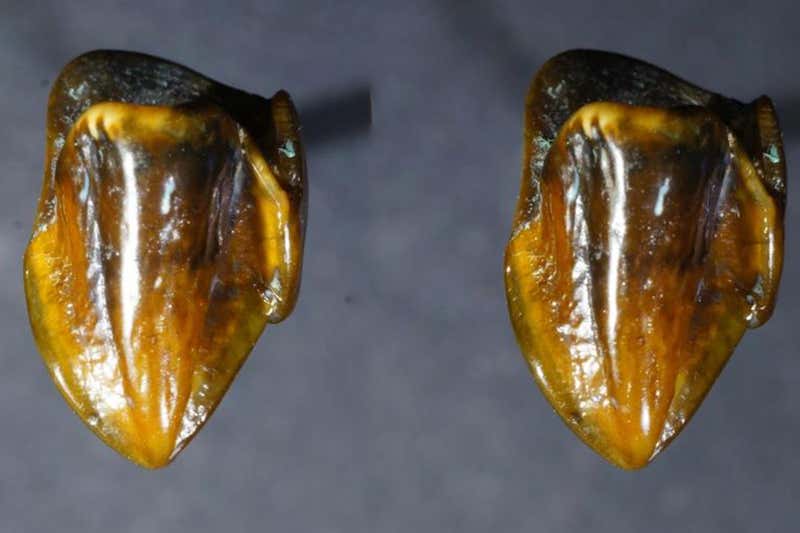
Both teeth are completely preserved, too. The teeth look “excellent” and are “shining like amber,” though no longer white, Lutz said.
The 9.7 million-year-old canine tooth and upper molar – found only 60 centimeters apart and thus believed to belong together – resemble those of great apes who lived in Africa 2.9 to 4.4 million years ago. According to Lutz and his colleagues, the teeth closely resemble some extinct African relatives of humans.

Since the official unveiling of the teeth, global media outlets have been questioning whether the find is capable of rewriting human history since it seems to go against theories of human beings originating from Africa.
The teeth are unlike anything found in Europe and Asia, Lutz cautiously claims.
“It’s a complete mystery where this individual came from, and why nobody’s ever found a tooth like this somewhere before,” he said in an interview with Research Gate.
But some experts say that the teeth hardly “force us to reexamine the theory that humans originated from Africa,” arguing that the fossils “more likely belonged to a very distant branch on the primate family tree,” reported National Geographic.
Other experts state that whether the teeth really belong to the hominoid classification (apes, chimpanzees, etc.) is questionable.
Expert on the teeth of humans’ extinct relatives and paleoanthropologist at the University of Toronto, Bence Viola, says the molar found contradicts any case for a human connection.
“I think this is much ado about nothing,” he told National Geographic. “The molar, which they say clearly comes from the same individual, is absolutely not a hominin, and I would say also not a hominoid.”
The majority of the experts National Geographic spoke to said the molar found likely belongs to a species of an extinct, primitive branch of primates that lived in Asia and Europe between seven and 17 million years ago.